Settlement in kutch region
•
10 likes•6,627 views

the presentation is about settlement in kutch. students of architecture or urban planner can refer this presentation.

Recommended
Recommended
More Related Content
What's hot
What's hot (20)
Viewers also liked
Viewers also liked (20)
Similar to Settlement in kutch region
Similar to Settlement in kutch region (20)
Recently uploaded
Recently uploaded (20)
Settlement in kutch region
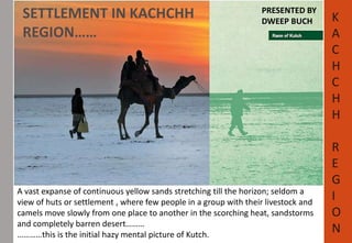
- 1. SETTLEMENT IN KACHCHH REGION…… PRESENTED BY DWEEP BUCH K A vast expanse of continuous yellow sands stretching till the horizon; seldom a view of huts or settlement , where few people in a group with their livestock and camels move slowly from one place to another in the scorching heat, sandstorms and completely barren desert……… …………this is the initial hazy mental picture of Kutch. A C H C H H R E G I O N
- 2. • Kutch means something which intermittently becomes wet and dry; a large part of this district is known as Rann of Kutch which is shallow wetland which submerges in water during the rainy season and becomes dry during other seasons. The same word is also used in the languages of Sanskrit origin for a tortoise. http://www.scribd.com/ http://kutchtravels.com/ K A C H C H H R E G I O N
- 3. GENERAL INTRODUCTION • Kutch district is the westernmost part of Gujarat state and second largest district in India bordering Pakistan. It is situated between the great deserts of Sind and Thar and the Arabian Sea. • Its area of 45,000sq. Km is mostly covered by salt marshlands of the Rann, Kutch is a unique landmass in India which has land and desert surrounded by sea water. • During the monsoons the two Ranns get flooded and for many inhabitants, Kutch becomes like an island cut off from the surrounding regions by swamps and salt marshes. • The district is also famous for ecologically important Banni grasslands with their seasonal marshy wetlands which form the outer belt of the Rann of Kutch. WETLAND DESERT + HILL + SEA http://en.wikipedia.org/wiki/Kutch_District BANNI GRASSLAND K A C H C H H R E G I O N
- 4. Area • Total 45,652 km 2 (17,626 sq mi) Population (2011) • Total 2,092,371 • Density 46/km 2 (120/sq mi) http://en.wikipedia.org/wiki/Kutch_District CLIMATE • The climate is unrelentingly hot and dry in the north and hot and humid in the south with a vast diurnal range of temperature(Max 48 degree C to Min 2 degree C) especially in winter. The scanty monsoon rains averaging a few centimetres annually(below 40 cm) fall mainly during the months of July and August. K A C H C H H R E G I O N TOPOGRAPHY • The landscape and ecosystems of Kutch vary from the Great Rann grasslands of Banni, the Dhand marshes, Kala dungar (BlackMountain) in Paccham, the plains of Lakhpat and Jakhau the mangrove swamps of Mundra and Koteshwar, the little Rann and the Gulf of Kutch with coral reefs and creeks.
- 5. K A C H C H H R E G I O N HISTORY OF KUTCH 4,500-year-old Harappan settlement excavated in Kutch Dholavira – The Indus Valley Civilisation
- 6. Dholavira Dholavira (Gujarati: ધોળાવીરા) is an archaeological site in Bhachau Taluka of Kutch District, on the Khadir bet island in the Kutch Desert in the state of Gujarat in western India. • The city of Dholavira has a rectangular shape and organization, and is spread over 22 ha (54 acres). • The area measures 771.1 m (2,530 ft) in length, and 616.85 m (2,023.8 ft) in width. There are main three divisions – the citadel, the middle town and the lower town. "Dholavira has indeed added new dimensions to personality of Indus Valley Civilisation." www,frontline.in K A C H C H H R E G I O N Google earth
- 7. http://asi.nic.in/asi_exca_2007_dholavira.asp K A C H C H H R E G I O N The acropolis and the middle town had been further furnished with their own defence-work, gateways, built-up areas, street system, wells and large open spaces. THE CITADEL One of the water reservoirs, with steps
- 8. CHRONOLOGY OF DHOLAVIRA Stages Dates Stage I 2650– 2550 BCE Early Harappan – Mature Harappan Transition A Stage II 2550– 2500 BCE Early Harappan – Mature Harappan Transition B Stage III 2500– 2200 BCE Mature Harappan A Stage IV 2200– 2000 BCE Mature Harappan B Stage V 2000– 1900 BCE Mature Harappan C 1900– 1850 BCE Period of desertion Stage VI 1850– 1750 BCE Posturban Harappan A 1750– 1650 BCE Period of desertion Stage VII 1650– 1450 BCE Posturban Harappan B K A C H C H H R E G I O N THE BAILEY STRUCTURE http://en.wikipedia.org/wiki/Dholavira http://asi.nic.in/asi_exca_2007_dholavira.asp
- 9. K A C H C H H R E G I O N COMMUNITY IN KUTCH AND THEIR LIFESTYLE… 1. RABARIS 3. AHIRS 2. JATS 4. HARIJANS
- 10. K A C H C H H R E G I O N RABARIS • Rabari people are a mystery of Kutch. Their lifestyle is completely different from any other tribe. There are 3 type of tribes in Kutch Desi Rabaris – live in the central & western sides of Kutch Dhebariya Rabaris – live near Anjar Taluka. Vagadiya Rabaris – live in the village named Vagad. • It is said that Rabaris originally came from jaisalmer of Rajasthan just like Mewar. • There are about 2500 to 3000 Rabari families in Kutch. JATS • About 500 years ago, these shepherds called Jats abroaded from Iran to Sindh and Kutch. • Jats usually live in tents or they stay in camps.they are mostly found in north-west side of Kutch, region of Lakhpat and Abdasa Talukas and in the dried Banni area. • Today,Jat women are famous for their microscopic mirror work embroidery that has found prepared market place.
- 11. K A C H C H H R E G I O N AHIRS • It is said that Ahirs are the children of Lord Krishna.There are 4 main castes of Ahirs in Kutch: Prantharia, Mochhaya, Baureecha and Sorathia. • About 3 lakhs Ahirs of the 18 million populations of Ahirs in India live in Kutch. • Prantharia Ahirs lived in eastern Kutch and they founded village named ‘Vrajvani’. The rest of the Ahirs are found near by Anjar Taluka . • Ahirs are principally farmers who once sold milk and ghee but they have changed their business because of irregularity of rain in Kutch. HARIJANS • Hari means God and Jan means people. Mahatma Gandhi gave the name ‘Harijan’ to the Meghwal people. • They are experts in weaving wool and cotton. They make gorgeous leather stitching and wood statue. • Meghwal live all over Kutch. They always live in groups.
- 12. K A C H C H H R E G I O N Traditional Circular House-form (Bhunga) in Kachchh • These traditional circular homes withstood the devastating earthquake (2001). • They are also considered cyclone proof. They can be constructed with local material Bhungas are mainly found in desert islands (fertile land in the middle of the desert) in the northern parts of Kutch region of Gujarat- specially Banni and Pachham (literally meaning pashchim- west) Exterior of bhunga http://aina.wikidot.com/ Interior
- 13. TIMELINE WISE SETTLEMENT IN KUTCH REGION Historical Timeline K A C H C H H R E G I O N
- 14. K A C H C H H R E G I O N TIMELINE WISE SETTLEMENT 12TH CENTUA RY FOUNDATION OF JADEJA COMMUNITY 1147 Jam lakh became a ruler of throne 1410 Muzaffar Shah took over Vaghad 1590 Kutch lost Morbi Estate 1605 Foundation of bhuj 1617 The coin Kori began in Kutch 1730 Sarbuland Khan attacked Kutch and was defeated 1762 The battle of Zhara started 1775 Sarfarazkhan attacked Kutch 1819 Kutch was damaged by disastrous earthquake 1842 Adhoi was included in morbi 1857 Kutch had disastrous drought 1870 Alfred High school started 1877 Art school started It was said that, in term of human destruction ‘ZARA” battle was biggest battle ever in the history of Gujarat. Lakhpat After the earthquake of 1819 a natural dam known as the Allahbund was formed, Indus river changed its course of flow and started flowing into the Arabian sea further north. Thus Lakhpat lost its importance as a port. The town is enclosed by 7km long 18th-century fort walls.
- 15. 1892 Swami Vivekananda in Kutch 1897 Kutch was troubled by plague 1902 Kutchi people held seminar in Mumbai for the state 1905 Anjar-Tuna Railway started 1921 The facility of bus started in Kutch 1923 Congress started the movement of Khadi 1925 Mahatma Gandhi in Kutch 1937 Postal services to Bhuj-Ahmedabad And Mumbai- Karachi started 1942 Experiment of Bomb making in Anjar 1948 Kutch was included under Indian govt. 1937 Postal services to Bhuj-Ahmedabad And Mumbai- Karachi started 1952 First Industrial Conference 1952 Establishment of Kandla port K A C H C H H R E G I O N Kandla port Coastal zone of Kutch
- 16. 1956 Earthquake damage Anjar 1956 Kutch was included under Maharashtra govt. 1959 Floods troubled Bhuj 1959 Lottery was banned 1960 Kutch became district of Gujarat State 1965 India-Pakistan war took place 1968 Charbet was lost 1969 First Broad gauge railway started 1971 India-Pakistan war took place 1998 Cyclone struck Kandla 1999 Cyclone struck again 2001 Earthquake destroyed Kutch K A C H C H H R E G I O N http://www.asanjokutch.com Villages like Bhachau, Samakhyali, Ratnal were almost 100% destroyed in 2001 earthquake.
- 17. K A C H C H H R E G I O N AFTER 2001….. REDEVELOPMENT OF THE REGION EXAMPLE OF BHUJ CITY…
- 18. K A C H C H H R E G I O N BHUJ • Bhuj the capital of the former native state of Kutch, is now the head quarter of the Kutch District. Bhuj was chosen by Rao khengarji-I as his capital in 1549. • The fort walls around the capital were built by Rao Deshalji in 1723. the city known as 5 large gate and 1 small window(chhathi bari). • The city wall, thirty five feet high and 4 feet thick with towers at irregular intervals was formerly armed with fifty one guns. The walls on the east and the west were demolished for the town's expansion. • It has a beautiful background of the Bhujjia hill fort in the east. In the heart of the town is Palace with Gothic structure. Bhuj Area Development Authority(http://www.bhujada.com/ The city in reference to Bhujjia hill fort DAMAGED IN EARTHQUAKE AFTER RENOVATION Prag Mahal – Gothic structure
- 19. K A C H C H H R E G I O N www.gsdma.org Bhuj City –Key Facts: • A 500 year old traditional unplanned city Headquarters of Kutch district –seat of district government • Population of about 1,50,000 • Strong Livelihood base - handicrafts and handloom work Disaster Profile • Earthquakes –Active seismic faults surround the city • Drought –every alternate year
- 20. K A C H C H H R E G I O N www.gsdma.org
- 21. K A C H C H H R E G I O N www.gsdma.org
- 22. www.frontline.in http://www.scribd.com/ http://kutchtravels.com/ http://en.wikipedia.org/wiki/Kutch_District http://en.wikipedia.org/wiki/Dholavira http://asi.nic.in/asi_exca_2007_dholavira.asp http://www.asanjokutch.com/ Bhuj Area Development Authority(http://www.bhujada.com/) K A C H C H H R E G I O N BIBLIOGRAPHY www.gsdma.org http://aina.wikidot.com/