Investing in disaster resilience risk transfer through flood insurance in south asia (poster) - final low resolution version
•
1 like•121 views

A glance at innovative flood risk management solutions through the provision of index-based insurance, which uses inundation models and remote sensing data, aimed at helping farmers increase their resilience.
Recommended

Recommended
More Related Content
What's hot
What's hot (20)
Similar to Investing in disaster resilience risk transfer through flood insurance in south asia (poster) - final low resolution version
Similar to Investing in disaster resilience risk transfer through flood insurance in south asia (poster) - final low resolution version (20)
More from CCAFS | CGIAR Research Program on Climate Change, Agriculture and Food Security
More from CCAFS | CGIAR Research Program on Climate Change, Agriculture and Food Security (20)
Recently uploaded
Recently uploaded (20)
Investing in disaster resilience risk transfer through flood insurance in south asia (poster) - final low resolution version
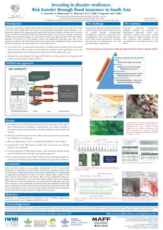
- 1. Investing in disaster resilience: Risk transfer through flood insurance in South Asia G. Amarnath1 , K. Matheswaran1 , N. Alahacoon1 , R. P. S. Malik2 , P. Aggarwal3 and A. Sikka2 1 International Water Management Institute (IWMI), Colombo, Sri Lanka 2 International Water Management Institute (IWMI), Delhi, India 3 CGIAR Research Program on Climate Change, Agriculture and Food Security (CCAFS), New Delhi, India RESEARCH PROGRAM ON Water, Land and Ecosystems www.fsm4.susana.org Protecting communities against floods and providing risk cover against the losses that could occur have been major areas of concern for governments around the world. Insurance is an important component in managing agricultural risks from these extreme climate events. In India, nearly 30 million smallholder farmers are affected by floods every year. For example, in the State of Bihar, the estimated damage to crops due to floods was approximately USD 600 million between 1979 and 2012. This situation needs to be addressed, especially since 80% of the population of Bihar (100 million) lives below the poverty line and depend mostly on agriculture for their livelihoods. The main objectives of this study were to: Estimating the damage caused to agriculture and the losses due to flood events needs to be verified through on-the-ground investigations. However, conducting such investigations is time consuming and often relief efforts by the government, including the provision of compensation, may not reach the target communities. Innovative flood-risk management solutions through the provision of index-based insurance, which uses inundation models and remote sensing data, aimed at helping farmers increase their resilience and contribute to the sustainability of agri-food systems in the future. Introduction The challenge The solutions set up pilot trials to demonstrate that positive verifiable impacts emerge from index-based flood insurance (IBFI) in terms of increasing the resilience of the agriculture sector, and improving productivity and household incomes at local and wider scales; and develop tools and strategies that support IBFI and its upscaling, which are integrated with existing and future flood control measures. For more information, contact Giriraj Amarnath (a.giriraj@cgiar.org) International Water Management Institute (IWMI) 127 Sunil Mawatha, Pelawatte, Battaramulla, Sri Lanka Mailing address P. O. Box 2075, Colombo, Sri Lanka Tel: +94 11 2880000, 2784080; Fax: +94 11 2786854 Email: iwmi@cgiar.org; Website: www.iwmi.org “Invest in insurance premiums to build agricultural resilience before disaster strikes” Method and approach World Bosai Forum/International Disaster and Risk Conference 2017 http://www.worldbosaiforum.com/english/overview/ Acknowledgements This research study was funded by the CGIAR Research Program (CRP) on Climate Change, Agriculture and Food Security (CCAFS); CGIAR Research Program on Water, Land and Ecosystems (WLE); Ministry of Agriculture, Forestry and Fisheries (MAFF), Japan; and the International Water Management Institute (IWMI). The contribution made by various government agencies in data sharing and providing valuable feedback is gratefully acknowledged. Reference Amarnath, G.; Vairavamoorthy, K.; Agarwal, A. 2017. Satellite imagery+crop insurance=farmers’ gain. Geospatial World 7(3): 58-61. Sendai, Japan November 25-28, 2017 Scaling up through business models, institutional/economic analysis Pilot implementation, community awareness and policy dialogue Projectcomponents Integration of space-based, hydrological and hydraulic information in the development of a flood index. Developed a new index-based insurance that uses information of the past 35 years of floods across floodplains in target districts. This made it possible to accurately estimate flood parameters, including inundation extent, depth and duration. Historical satellite images from the 1980s to date were used for assessment and validation of crop damage. IBFI was implemented in 2017 covering 200 households in nine villages. Development of the IBFI business model and carrying out an economic analysis were completed. Creating awareness of IBFI among farmers, and cultivating equality among men and women farmers through a participatory approach. Policy analysis and provision of IBFI in district disaster management plans for protecting communities against floods and enhancing agricultural resilience. Results Figure 1. Flood depth and duration obtained from hydrological and hydraulic models. Figure 2. Parameters of a typical IBFI product. Figure 3. Payout to pilot villages in Bihar will be based on historical data. Figure 4. Rapid emergency response map derived from Sentinel-1 satellite data for floods in August 2017. India’s first IBFI scheme was successfully implemented in 2017 covering 200 households in Muzaffarpur District, Bihar. A post-flood management plan using flood parameters (depth and duration) derived from satellite data was implemented for agricultural development in India. As climate change makes weather events such as floods more frequent and intense, IBFI can help smallholder farmers to reduce their vulnerability to such events and help to protect their assets. Further, IBFI promotes a closer linkage between risk transfer and risk reduction, and could hence make this a more sustainable and robust tool for flood-affected communities and in reducing the burden of post-disaster relief funding for the government. IBFI has the potential to be a part of a more wide-ranging and multi-faceted approach to ensure that India remains resilient to floods in years to come. Conclusion (a) IBFI project sites in India and Bangladesh; (b) inundated households in northern Bihar in September 2016; and (c) floods in Bihar captured by the National Aeronautics and Space Administration’s (NASA’s) Moderate Resolution Imaging Spectroradiometer (MODIS) on August 22, 2007. (a) (b) (c) Project website: http://ibfi.iwmi.org/ Gender and inclusion through participatory approach Flood-risk mapping and site selection Flood index design and pricing