Emerging Hot Spot Analysis
•Download as PPTX, PDF•
3 likes•1,214 views

Using big data analysis and ESRI's emerging hot spots analysis tool to look at deforestation through space and time

Recommended
More Related Content
What's hot
What's hot (20)
Viewers also liked
Viewers also liked (9)
Similar to Emerging Hot Spot Analysis
Similar to Emerging Hot Spot Analysis (8)
More from Blue Raster
More from Blue Raster (20)
Recently uploaded
Recently uploaded (20)
Emerging Hot Spot Analysis
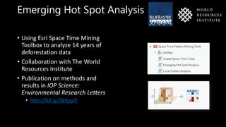
- 1. Emerging Hot Spot Analysis • Using Esri Space Time Mining Toolbox to analyze 14 years of deforestation data • Collaboration with The World Resources Institute • Publication on methods and results in IOP Science: Environmental Research Letters • http://bit.ly/2k9gq7r
- 2. The Data: Global Forest Cover Loss (2001-2014) Source: Hansen/UMD/Google/USGS/NASA
- 3. Global Map of Forest Loss Data 504 10° x 10° Granules
- 4. How Did We Do It? Raw Data Big Data Analysis GIS Analysis Symbolization / Sharing
- 5. What is Emerging Hot Spot Analysis? • Finding trends by analyzing space (xy) and time (t) • Minimum 10 observations (time step intervals) • Getis-Ord Gi* determines if a bin is a statistically significant hot or cold spot • Mann-Kendall trend test evaluates hot and cold spots through time to produce categories such as Intensifying, Diminishing or New hot spot
- 6. What Do The Results Look Like?
- 7. Symbolizing a Forest- Loss Narrative
- 8. Creating a scalable workflow I N D O N E S I A Brazil DRC Indonesia
- 9. Batch runs using Python
- 10. National Level Analysis (Default Symbology)
- 11. National Level Analysis (Less Categories, Updated Symbology)
- 13. National Level vs Sub-National Analysis (Brazil)
- 14. Thank you! Learn more at: www.blueraster.com
Editor's Notes
- Next steps: Analysis with 2015 data coming soon