SlideShare a Scribd company logo
1 of 118
Download to read offline
What Is at Stake for the Philippines
What is at stake in the West Philippine Sea dispute are:
a.  80% of of the Philippines’ exclusive economic zone (EEZ),
comprising 381,000 square kilometers of maritime space, and
b.  100% of the Philippines’ extended continental shelf (ECS),
estimated at over 150,000 square kilometers of maritime space,
aggregating a huge maritime area of over 531,000 square kilometers,
larger than the total land area of the Philippines of 300,000 square
kilometers - either the Philippines keeps this huge maritime
space, or loses it to China.
Area of Maritime Space at Stake in Dispute
The root cause of the South China Sea
dispute is China’s 9-dashed lines claim,
which gobbles up large areas of the EEZs and
ECSs of the Philippines, Vietnam, Malaysia,
Brunei and Indonesia.
Root Cause of South China Sea Dispute
China’s “National Boundaries” Gobble Up EEZs of Coastal States
China’s 9-dashed lines claim encloses 85.7% of the entire South China Sea. This is
equivalent to 3 million square kilometers out of the 3.5 million square kilometers surface
area of the South China Sea.
Nine-dashed Lines Map
Submitted by
China to United Nations
on 7 May 2009
China did not explain the
legal basis for the dashes.
The dashes had no fixed
coordinates.
The Philippines, Vietnam,
Malaysia and Indonesia
protested China’s claim
under this 9-dashed lines
map.
“China has indisputable sovereignty over the islands in the South
China Sea and the adjacent waters, and enjoys sovereign rights
and jurisdiction over the relevant waters as well as the seabed
and subsoil thereof.” - China’s Note Verbale
The terms “adjacent” and “relevant” waters are not UNCLOS
terms. China refuses to explain the meaning of “adjacent” or
“relevant” waters. Do these terms mean that China claims all the
waters and resources enclosed by the 9-dashed lines?
We shall examine China’s acts, regulations, declarations, and
practices in the South China Sea to understand what China
means by its 9-dashed lines claim, and how China interprets and
applies the terms “adjacent” and “relevant” waters.
China’s 2009 Note Verbale Explaining
The 9-dashed Lines Map
China Seized Subi Reef in 1988
In 1988, China seized Subi Reef from the Philippines by erecting a radar structure and military
facilities on the reef. Subi Reef is a Low-Tide Elevation (LTE) outside of the Philippines’ EEZ but
within its extended continental shelf (ECS). Subi Reef is just outside the 12 NM territorial sea of the
Philippine-occupied Pagasa (Thitu) Island. Under UNCLOS, only the Philippines can erect structures
or create an artificial island on Subi Reef. The waters of Subi Reef are part of the high seas of the
South China Sea.
China Seized Mischief (Panganiban) Reef in 1995
In 1995, China seized Mischief Reef from the Philippines. Mischief Reef, located 125 NM
from Palawan, is a Low-Tide Elevation (LTE) within the Philippines’ EEZ. As an LTE
beyond the territorial sea of any state, it is part of the submerged continental shelf of the
adjacent coastal state, which is the Philippines. Under UNCLOS, only the Philippines can
exploit its natural resources or erect structures on it.
China Claimed Reed Bank in 2010
In February 2010, the Philippines awarded a Service Contract to Sterling Energy (predecessor of Forum Energy) for Block SC 72 in the
Reed Bank. China protested, sending a Note Verbale to the Philippines on 22 February 2010, "express[ing] its strong objection and
indignation,” and asserting "indisputable sovereignty, sovereign rights and jurisdiction over the Nansha Islands (Spratlys) and its
adjacent waters.” China demanded that the Philippines "withdraw the Service Contract immediately.” China sent another Note Verbale
on 13 May 2010 again demanding that the Philippines "immediately withdraw the decision to award the Service Contract” to Sterling
Energy. Block SC 72 is 85 NM from Palawan, well within the Philippines’ EEZ, and 595 NM from Hainan.
China Interfered Directly with a Philippine Service Contractor for Reed Bank in 2010
On 2 August 2010, the Nido Petroleum office in Manila received an email directly from the Chinese Embassy in Manila. The Embassy
requested a meeting between the Chinese First Secretary and the Nido vice-president. The meeting was held on 6 August 2010. The
Chinese First Secretary showed the Nido vice-president a map depicting China's 9-dashed lines, and informed him that the area covered
by Nido Petroleum’s service contract (Block SC 58) was "claimed by" the People’s Republic of China. Since then Nido Petroleum has not
made any exploration within Block SC 58.
[Memorandum from Rafael E. Seguis, Undersecretary for Special and Ocean Concerns, Department of Foreign Affairs, Republic of the Philippines, to the Secretary
of Foreign Affairs of the Republic of the Philippines (30 July 2010); Letter from Mr. Anthony P. Ferrer, Country Representative, Nido Petroleum, to the Office of the
Undersecretary, Department of Energy of the Republic of Philippines (7 Oct. 2013)]	
Nido Exploration
Area
China Reiterated its Claim to Reed Bank in 2011
In 2011, the Philippines invited bids for the exploration of Area 3 and Area 4 in the Reed Bank,
well within the Philippines’ EEZ. On 4 July 2011, China protested and sent a Note Verbale to
the Philippines, stating: “The Chinese government urges the Philippine side to immediately
withdraw the bidding offer in Areas 3 and 4, refrain from any action that infringes on China's
sovereignty and sovereign rights.”
Chinese Coast Guard Vessels Harassed
A Philippine Survey Ship in Reed Bank in 2011
In March 2011, two Chinese coast guard vessels, the CMS-71 and CMS-75, prevented a
Philippine-commissioned ship, the MV Veritas Voyager, from undertaking oil and gas survey
in the Reed Bank, which is entirely within the Philippines’ EEZ. The 9-dashed lines cut
through Malampaya, the Philippines’ largest operating gas field which supplies 40% of the
energy requirement of Luzon. Malampaya will run out of gas in 10-12 years.
In 2012, China invited an
international bidding for the
exploration of areas within
the EEZ of Vietnam.
China published this map,
naming it “Location for part
of open blocks in waters
under jurisdiction of the
People’s Republic of China
available for foreign
cooperation in the
year of 2012.”
China Auctioned off Areas within Vietnam’s
EEZ & ECS
In 2013, China released a new map of China, adding a 10th dash on the
eastern side of Taiwan. In its 2013 map, China claims the 10-dashed lines
are its “national boundaries,” without again explaining the legal basis or
giving the fixed coordinates for the dashes. The 2013 China map was
published by SinoMaps Press, under the jurisdiction of China’s State
Bureau of Surveying and Mapping. This means the 2013 Map is an official
Chinese government map.
In its Note Verbale of June 7, 2013 to China, the Philippines stated it
"strongly objects to the indication that the nine-dash lines are China's
national boundaries in the West Philippine Sea/South China Sea.”
China’s claim that the 9-dashed lines are China’s “national boundaries”
contradicts its assurance to the world that there is “freedom of navigation
and overflight in the South China Sea in accordance with international
law.”
China’s 2013 Map with 10-dashed Lines
As “National Boundaries”
China Claims 10-dashed Lines
in 2013 Map Are China’s
“National Boundaries”
James Shoal - China’s “Southernmost” Border
Since at least 2012, China has been
periodically laying sovereignty steel
markers on the seabed of James
Shoal. China claims James Shoal as
its southernmost border. James
Shoal is fully submerged at 22
meters below the water surface,
and is situated more than 950 NM
from Hainan Island and more
than 400 NM from Itu Aba.
Under UNCLOS, the maximum
maritime zone that a state can
claim is 350 NM from baselines
along its coast (or 100 NM from
the 2500m isobath, a limitation
which does not apply to China
based on the geology of the South
China Sea).
Under international law, a state’s border
must either be a land territory, a river, or a
territorial sea - which are all subject to its
full sovereignty. A state cannot appropriate
as its sovereign territory a fully submerged
area beyond its territorial sea. James Shoal
is 80 KM from Malaysia’s coast in Bintulu,
Sarawak, within Malaysia’s EEZ.
China Holds	Sovereignty Oath Swearing Ceremony
at James Shoal in January 2014
A Chinese taskforce composed of three warships from the South China Sea Fleet of the Navy
of the Chinese People’s Liberation Army (PLAN) held a sovereignty oath-swearing ceremony
on January 26, 2014 in the waters of James (Zengmu) Shoal off the coast of Sarawak, Borneo
in the South China Sea. The Singapore Straits Times quoted China’s Foreign Ministry
spokesman Qin Gang that Malaysia did not lodge any protest against China. Photo: Xinhua
China Seized Scarborough (Panatag) Shoal in 2012
In 2012, China seized Scarborough Shoal from the Philippines. In November 2012, following a three-month standoff
between Philippine and Chinese vessels around the shoal, China informed the Philippines that Chinese coast guard
vessels would remain permanently on the shoal. Scarborough Shoal, including its lagoon, has an area of 58 square
miles or 150 square KMs (15,000 hectares). Located 124 NM from Zambales, Scarborough Shoal is rich in fisheries
and is one of the traditional fishing grounds of Filipino fishermen. The shoal is a high tide elevation, with the biggest
rock protruding 1.2 meter above water at high tide. China claims that Scarborough Shoal generates a 200 NM EEZ.
China Seized Luconia Shoals in 2013
In 2013, China seized Luconia Shoals from
Malaysia. Malaysian National Security
Minister Shahidan Kassim posted on
Facebook last June 4, 2015 the location map
of Luconia Shoals, 54 NM from Sarawak,
with this statement: "This small island is
not a disputed territory but the foreign
ship which came here has intruded into
our national waters.”
That foreign ship is the Chinese Coast
Guard vessel Haijing 1123, which anchored
on Luconia Shoals since April 2013 and has
remained there up to now.
Luconia Shoals, covering 100 square miles,
are one of the largest reef formations in the
South China Sea. Luconia Shoals, with a
sandbar above water at high tide, are rich in
fish, oil and gas. China claims that all
geologic features in the Spratlys generate a
200 NM EEZ.
China Installed HD 981 Oil Rig in 2014
In 2014, China placed its $1 billion deep-water HD 981 oil rig 130 NM from Vietnam’s coast,
well within Vietnam’s EEZ. In protest, Vietnamese workers in export processing zones in
Vietnam rioted, burning several Chinese factories. A Vietnamese fishing boat sank near the oil
rig after being rammed by a Chinese vessel. Recent reports reveal that China is building three
(3) more type HD 981 rigs for deployment in the South China Sea.
Article 35 of the Hainan Province’s 2014 Fishery
Regulations, which took effect on January 1, 2014,
mandate that foreign fishing vessels “entering the
waters under the jurisdiction of this province
(Hainan) to engage in fishery operations or fishery
resource surveys shall secure approval from
relevant departments of the State Council.”
The Fishery Regulations apply to Macclesfield
Bank, which is part of the high seas.
Hainan’s 2014 Fishery Regulations
Waters Hainan Claims under its Administration
The enclosed waters under Hainan’s administration comprise 2 million square kilometers out of the 3.5 square
kilometers total surface area of the South China Sea. China claims a total of 3 million square kilometers or 85.7% of
the waters of the South China Sea. Macclesfield Bank, which is part of the high seas, is within the enclosed waters.
Since 1999, China thru Hainan Province has imposed
unilaterally a three-month annual fishing moratorium, from
mid-May to end July, on waters in and around the Paracels,
Macclesfield Bank and Scarborough Shoal. Violators of the
ban face fines, confiscation of fishing equipment, and even
criminal charges. Macclesfield Bank is part of the high seas.
In a Note Verbale dated 6 July 2015, China demanded that the
Philippines “respect China's territorial sovereignty, sovereign
rights and jurisdiction, and xxx educate its own fishermen,
so that they can strictly abide by the fishing moratorium
xxx." China warned that "Chinese law-enforcing authorities
will strengthen their maritime patrols and other law-enforcing
actions, investigate and punish the relevant fishing vessels
and fishermen who violate the fishing moratorium xxx.”
China Imposes a Unilateral Annual 3-Month
Fishing Moratorium In the South China Sea
The high seas have always been part of the global
commons, whether before or after UNCLOS. The high
seas could not be subject to sovereignty by any state,
whether before or after UNCLOS.
UNCLOS declares: “The high seas are open to all
states, whether coastal or land-locked. Freedom of the
high seas xxx comprises, inter alia, xxx freedom of
fishing” (Art. 87, UNCLOS).
UNCLOS declares: “No state may validly purport to
subject any part of the high seas to its sovereignty” (Art.
89, UNCLOS).
The High Seas Part of Global Commons
By appropriating for itself the fishery resources in
the high seas of the South China Sea, China is
committing a grand theft of the global commons.
All states, coastal and landlocked, are interested
parties in the South China Sea dispute because
China is appropriating for itself the fishery
resources in the high seas.
Grand Theft of the Global Commons
All these acts of China, among so many
others, demonstrate beyond doubt that
China is claiming sovereignty, sovereign
rights and jurisdiction to all the waters,
fisheries, oil, gas, mineral resources, seabed
and subsoil enclosed by the 9-dashed lines.
The South China Sea - A Chinese Lake
The Philippines loses about 80% of its EEZ facing
the West Philippine Sea, including the entire Reed
Bank and part of the Malampaya gas field. Malaysia
loses also about 80% of its EEZ in Sabah and
Sarawak facing the South China Sea, as well as most
of its active gas and oil fields in the same area.
Vietnam loses about 50% of its total EEZ. Brunei
loses about 90% of its total EEZ. Indonesia loses
about 30% of its EEZ facing the South China Sea
in Natuna Islands, whose surrounding waters
comprise the largest gas field in Southeast Asia.
What is the Effect of China’s “National
Boundaries” under the 9-dashed Lines?
Philippines’ Sliver of Territorial Sea and EEZ
The Philippines will be left with a sliver of water as its territorial sea and EEZ. The
Philippines and China will have a very long common sea border – 1,300 kms – from
Balabac Island in southern Palawan to Yamin Island in northern Batanes. The dashed
lines are just 64 KMs from Balabac Island, 70 KMs from the coast of Burgos, Ilocos Norte,
and 44 KMs from Yamin Island.
Maritime Zones under UNCLOS
An island above water at high tide is entitled to a 12 NM territorial sea. If such island is capable of human habitation or economic life of its
own, it is entitled to a 200 NM EEZ. If there is a natural prolongation of its extended continental shelf, it is entitled to an ECS up to
where the natural prolongation ends, but not exceeding 150 NM from the outer limits of its EEZ. The maximum maritime zone a coastal
state can claim is 150 NM from the outer limits of its 200 NM EEZ (or 100 NM from the 2500 meter isobath, a limitation which does not
apply to China based on the geology and geomorphology of the South China Sea). China is claiming maritime zones more than 150 NM
from the outer limits of its EEZ.
A Low-Tide Elevation (LTE) is a naturally formed
area of land (rock, reef, atoll or sandbar)
surrounded by water, above water at low tide but
submerged at high tide.
An LTE is part of the submerged continental shelf.
An LTE is not land or territory, and has no
territorial sea or territorial airspace (Art. 13,
UNCLOS). An LTE beyond the territorial sea is
not subject to appropriation by any State
(Nicaragua v. Colombia, ICJ, 2012).
Low-Tide Elevation (LTE)
Low Tide Elevation vs. Rock/Island
A low-tide elevation is not entitled to a territorial sea or any maritime zone. A rock above water at high tide is
entitled to a 12 NM territorial sea. An island capable of human habitation or economic life of its own is entitled to a
12 NM territorial sea and a 200 NM EEZ, and if there is a natural prolongation of its extended continental shelf, it
is entitled to an ECS up to the end of such natural prolongation but not exceeding 150 NM from the outer limits of
its EEZ (or 100 NM from the 2500 meter isobath, if applicable).
China has built artificial islands on seven (7) reefs: Fiery Cross Reef,
Cuarteron Reef, Gaven Reef, Johnson South Reef, McKennan Reef,
Mischief Reef and Subi Reef. These are all the reefs China occupies.
However, China has actually also dredged ten (10) other reefs for
filling materials for the seven reefs on which China has built islands.*
China has explained: “The primary purpose of these activities is to
improve the working and living conditions of personnel stationed
there, to better fulfill our international obligations concerning
maritime search and rescue, disaster prevention, and mitigation, and
to enable China to provide better services to vessels from China, her
neighbors, and other countries sailing in the South China Sea.”**
* J. Ashley Roach, an ASIL member, Captain, JAGC, USN (retired), Office of the Legal Adviser, U.S. Department
of State (retired), and Global Associate and Senior Visiting Scholar at the Centre for International Law (CIL)
(2014–2015), National University of Singapore; see http://english.vietnamnet.vn/fms/marine-sovereignty/
137126/china-s-shifting-sands-in-the-spratlys.html
**Statement of Wang Min, China's deputy permanent representative to the United Nations.
China’s Island-Building in the Spratlys
China’s Island-Building on Seven Reefs
There are about 750 small maritime features in the Spratlys. The vast majority are submerged at all
times while others are exposed only at low tide. There are, at most, only 28 features that remain above
water at high tide. The largest high-tide feature, Itu Aba, is only 0.43 square kilometer. The rest range
in size from a high of 0.36 square kilometers (Pagasa) to a low of less than 2 square meters.
Fiery Cross (Kagitingan) Reef Before Island-Building
Fiery Cross Reef is about 1 meter above water at high tide. It is just outside the Philippines’ EEZ but
within its continental shelf. In 1987, UNESCO agreed that China would build a weather station on
Fiery Cross Reef as part of UNESCO’s global oceanic survey. That weather station would later turn
out to be a Chinese military air and naval base.
China’s Airbase with Seaport on Fiery Cross Reef
Source: China State Shipbuilding Corporation
One of the islands built by China is an airbase with a seaport, completed in
June 2015. The airbase, with a 3,000 meter runway, is on a 274-hectare area
on Fiery Cross Reef, larger than 213-hectare Woody Island which hosts
China’s airbase in the Paracels. This artificial island will also be larger than
the combined area of the 20 largest islands in the Spratlys, and more than
twice the area of Diego Garcia Island, the U.S. airbase in the Indian Ocean.
June 2015 Chinese Photo of Completed Island-Building on
Fiery Cross Reef - 274 Hectare Airbase With 3 KM Runway
As Admiral Harry Harris, commander of the U.S. Pacific Command stated, “A 10,000-foot
(3 KM) runway is large enough to take a B-52, almost large enough for the Space Shuttle,
and 3,000 feet longer than what you need to take off a 747.” Admiral Harris also stated
that China is building on Fiery Cross Reef hangars for tactical fighters.
China’s Strategic Bomber H-6K
with 7,000 KM Range
The H-6K can carry under its wing pylons six conventional or nuclear armed CJ-10A cruise
missiles with 2,200 KM range. Although the H-6 was first domestically produced in 1968,
this upgraded version, using composite materials, modern avionics and a powerful radar,
first entered service only in October 2009.
Test Flights on Fiery Cross Reef Runway - January 6, 2016
Johnson South (Mabini) Reef Before Island-Building
Johnson South Reef is an LTE within the Philippines’ EEZ. [Note: Chinese, Philippine
and other countries’ nautical charts designate this as an LTE. Only the U.S. nautical chart
designates this as a high tide feature.]
Johnson South (Mabini) Reef December 26, 2015
In 1988, Chinese naval forces forcibly dislodged the Vietnamese soldiers guarding this LTE. Over 77
Vietnamese soldiers died in the battle. Johnson South Reef is within the Philippines’ EEZ. As of
November 2015, China has created an artificial island of 10.9 hectares in Johnson South Reef.
McKennan (Chigua) Reef Before Island-Building
McKennan Reef is an LTE within the Philippines’ EEZ. It is within 12 NM of Sin
Cowe Island.
McKennan (Chigua, Hughes) Reef May 5, 2015
As of November 2015, China has created an artifical island of 7.2 hectares in McKennan
Reef.
Gaven (Burgos) Reef at Start of Island-Building
Gaven Reef is outside of the Philippines’ EEZ but within its continental shelf. Gaven Reef is
an LTE within 12 NM of Namyit Island.
Gaven Reef May 9, 2015
As of November 2015, China has created an artificial island of 13.6 hectares in Gaven
Reef.
Cuarteron (Calderon) Reef Before Island-Building
Cuarteron Reef is outside the Philippines’ EEZ but within its continental shelf. It is above
water at high tide.
Cuarteron Reef May 7, 2015
Cuarteron Reef is a tiny rock above water at high tide just outside the Philippines’ EEZ. As
of November 2015, China has added 24.6 hectares to Cuarteron Reef.
Subi (Zamora) Reef Before Island-Building
Subi Reef is an LTE outside of the Philippines’ EEZ but within its continental shelf. Subi Reef is just
outside the 12-NM territorial sea of the 36-hectare Pagasa (Thitu) Island, the largest island occupied by
the Philippines in the Spratlys. Subi Reef is 231 NM from Palawan and 502 NM from Hainan.
Subi (Zamora) Reef December 23, 2015
3 km runway/air strip
Center Portion of Subi Reef Runway December 21, 2015
Source:www.ft.com
Subi (Zamora) Reef January 8, 2016
Source:www.+.com	
Under UNCLOS, Subi Reef, an LTE in the high seas, cannot be used as a military facility.
Article 88 of UNCLOS mandates that “the high seas shall be reserved for peaceful
purposes.” The total area of Subi Reef, including the lagoon and rim of the reef, is 16 sq.
km. In its original state, the Subi Reef‘s lagoon was 22 meters deep. Subi Reef’s location,
size and depth make it ideal for a naval base with an airfield. As of December 23, 2015,
China has created an artificial island of 500 hectares in Subi Reef.
Mischief (Panganiban) Reef
January 2012 and March 2015
Mischief Reef is a circular atoll with a diameter of 7.4 KM, and its lagoon has an area of 3,600 hectares.
The average depth inside the lagoon is 26 meters. As of November 2015, China has created an artificial
island of 590 hectares out of a planned 800 hectares. China can garrison thousands of troops on
Mischief Reef. Mischief Reef is 125 NM from Palawan and 596 NM from Hainan.
Mischief (Panganiban) Reef December 24, 2015
3 Km runway/air strip
Mischief (Panganiban) Reef January 8, 2016
The northwest side of Mischief Reef as of January 8, including a 1,900 foot seawall and
newly-constructed infrastructure including housing, an artificial turf parade grounds,
cement plants, and docking facilities. - Source: www.ft.com
Mischief Reef and Palawan, 125 NM Distance
Mischief Reef is an LTE that is 125 NM from Palawan, well within the 200 NM EEZ of the Philippines.
As an LTE, Mischief Reef is part of the submerged continental shelf of the Philippines. With an air and
naval base in Mischief Reef between Palawan and all the Philippine-occupied islands in the Spratlys,
China can block Philippine ships re-supplying Philippine-occupied islands in the Spratlys.
China’s island-building violates the 2002 Asean-
China Declaration of Conduct, which states that
the parties undertake to exercise self-restraint, like
“refraining from action of inhabiting on presently
uninhabited islands, reefs, shoals, cays and other
features.”
Island-Building Violates the Declaration of Conduct
China’s New Airbase on Woody Island, the Paracels
Woody Island has an area of 213 hectares. It has a a 2,700 meter runaway that can handle
all of China’s 4th generation fighter aircraft as well as the H-6K strategic bomber.
An ADIZ in the South China Sea?
China conducted in June 2015 its first air-sea military drill in the Bashi Channel between
Taiwan and the Philippines. China announced that in the future it would conduct regular
air-sea military drills in the Bashi Channel.
China is mass-producing destroyers, frigates,
corvettes and other warships at a faster rate than any
other country in world history during peacetime.
According to the U.S. Office of Naval Intelligence,
“During 2014 alone, more than 60 naval ships and
crafts were laid down, launched, or commissioned,
with a similar number expected through the end of
2015.”
China’s Continuing Mass Production of Warships
China’s Type 056 Corvette
China launched its 25th Type 056 Corvette last March 19, 2015, out of a total planned 40
Type 056 Corvette fleet. The PLA Navy believes that it can control the South China Sea
with 20 of these Corvettes.
China’s Second Navy - The Coast Guard
China will deploy this year a 10,000-ton coast guard vessel, the world’s largest blue water
coast guard vessel. A second 10,000-ton sister ship is under construction. China has more
coast guard vessels than Japan, Vietnam, Indonesia, Malaysia and the Philippines
combined. China’s Coast Guard is the largest blue water coast guard fleet in the world.
2015 China Military Strategy
Under its 2015 “China Military Strategy,” China will shift from “offshore waters defense” to
the combined “offshore waters defense” and “open seas protection.” The CMS states: “The
traditional mentality that land outweighs the sea must be abandoned, and great importance
has to be attached to managing the seas and oceans and protecting maritime rights and
interests.”
China’s Creeping Expansion in the SCS from 1946 to 2016
Before World War II, China’s
southernmost defense perimeter
was Hainan Island. Before the
war, China did not have a single
soldier or sailor stationed in any
SCS island outside of Hainan
Island. Right after the war,
China took over the Amphitrite
Group of the Paracels and Itu
Aba in the Spratlys following the
defeat of the Japanese, moving
China’s defense perimeter
southward. In 1974, China
forcibly dislodged the South
Vietnamese from the Crescent
Group of the Paracels. In 1988,
China forcibly evicted Vietnam
from Johnson South Reef,
moving further south China’s
defense perimeter in the
Spratlys.
In 1995, China seized Mischief Reef from the Philippines, just 125 NM
from Palawan and 594 NM from Hainan. In 2012, China seized
Scarborough Shoal from the Philippines, just 124 NM from Luzon. In
2013, China seized Luconia Shoals from Malaysia, just 54 NM from
Sarawak’s coast. In 2014, China started island-building on rocks and
submerged areas in the Spratlys to construct air and naval bases.
China’s grand design is to control the South China Sea for economic and military
purposes. China wants all the fisheries, oil, gas and mineral resources within the 9-
dashed lines. China already takes 50% of the annual fish catch in the South China
Sea as more than 80% of its coastal waters are already polluted. China has the
largest fishing fleet in the world with 70,000 vessels. China’s per capita fish
consumption is the highest in the world at 35.1 kg/year to feed 1.4 billion people,
while the rest of Asia’s per capita consumption is only 21.6 kg/year.
China is the largest net importer of petroleum in the world. The South China Sea is
rich in methane hydrates - said to be one of the fuels of the future. China wants to
secure all these methane hydrates for itself.
China also wants the South China Sea as a sanctuary for its nuclear-armed
submarines – free from surveillance by U.S. submarine-hunting Poseidon airplanes
or U.S. nuclear attack submarines.
The island-building in the Spratlys is not a knee-jerk response to the Philippines’
arbitration case but part of China’s long-term grand design. As Zang Jie, head of the
Asia Pacific Security program at the government-linked Chinese Academy of Social
Sciences, stated: “China has wanted to do this for a long time. Now it has the
dredging boats, the money and the people. So it is doing it.”
China’s Grand Design in the South China Sea
Mischief Reef - A 30-Million Year Work of Nature
It takes 30 million years for the reefs of an atoll like Mischief Reef to form. Reefs are the breeding
ground of fish. In the Spratlys, the eggs and larvae spawned by fish are carried by currents to the Sulu
Sea, the coasts of Palawan, Luzon, Malaysia, Brunei, Indonesia, Vietnam and even China. All the
reefs in the seven built-up sites of China are now dead. Reefs need clear waters to grow. Island-
building makes the waters in nearby reefs turbid, unhealthy for both reefs and fish. The coral reefs in
the South China Sea comprise 34% of the world’s total coral reefs, despite the South China Sea
occupying only 2.5% of world’s total ocean surface.
Chinese Reef Killer Dredges 4,500 Cubic Meters of Sand per Hour
The Tiang Jing Hao (Heavenly Whale) dredger, a 127 meter-long seagoing cutter suction
dredger designed by the German engineering company Vosta LMG. At 6,017 gross tons,
this dredger is the largest in Asia. China has dozens of dredgers in the Spratlys.
How Dredging Is Done in the Spratlys
Coral reef and hard sediment on the seabed are pulverized by the rotating cutter.
Pulverized materials are sucked into the ship. Pulverized materials are transported
by pressure through a floating pipe. Pulverized materials are deposited on the rim
of the reef.
Fiery Cross Reef January 28, 2015
According to Dr. John McManus, a renowned marine biologist who has studied the
marine life in the Spratlys, China’s island-building is the “most rapid permanent loss of
coral reef in human history. It’s a terrible, terrible thing to do this.”
Only the adjacent coastal state has the right to
create artificial islands, or erect structures on LTEs,
within its EEZ or ECS (Arts. 60 & 80, UNCLOS).
Thus, such artificial islands or structures put up by
other states within the EEZ or ECS of a coastal
state are illegal under UNCLOS.
Who can create artificial islands, or erect structures
on LTEs, in the EEZ or ECS?
Thus, Article 60, Part VI of UNCLOS, on “Artificial islands,
installations and structures in the exclusive economic zone,” states:
“1. In the exclusive economic zone, the coastal State shall
have the exclusive right to construct and to authorize
and regulate the construction, operation and use of:
(a) artificial islands;
(b) installations and structures for the purposes
provided in Article 56 (exploitation of non-
living resources in the seabed, marine scientific
research, protection and preservation of
marine environment) and other economic purposes;
(c) xxx.”
“2. The coastal state shall have exclusive jurisdiction over
such artificial islands, installations and structures,
including jurisdiction with regard to customs, fiscal,
health safety and immigration laws and regulations.”
Article 80, Part VI of UNCLOS, on “Artificial
islands, installations and structures on the continental
shelf,” states:
“Article 60 applies mutatis mutandi to artificial
islands, installations and structures on the
continental shelf.”
Clearly, China’s island-building on LTEs in the EEZ
and ECS of the Philippines violate UNCLOS and
are thus illegal under international law.
Maritime Zones under UNCLOS
No. UNCLOS defines an island as a “naturally formed” area of land,
surrounded by water, and above water at high tide. (Art. 121, UNCLOS)
Article 60(8) of UNCLOS provides:
“8. Artificial islands, installations and structures do not possess the
status of islands. They have no territorial sea of their own, and their
presence does not affect the delimitation of the territorial sea, the
exclusive economic zone, or the continental shelf.”
Article 2(2) of UNCLOS states that “sovereignty extends to the air space
over the territorial sea.” While a coastal state’s artificial structure installed
within its own EEZ is entitled to 500-meter safety zone (Article 60(5),
UNCLOS), an illegally installed structure by another state is not entitled to
this legal 500-meter safety zone. A legal right cannot arise from an illegal act.
Do LTEs and artificial islands acquire a maritime zone if by
island-building they are raised above water at high tide ?
Historic rights cannot be invoked to claim natural resources in the EEZ of
another state. UNCLOS granted to coastal states “sovereign rights” to
exploit its EEZ. “Sovereign rights” means supreme rights, superior to the
rights of other states. This extinguished all historic rights or claims by other
states in the EEZ of a coastal state. The word “exclusive” in the term EEZ
means the economic exploitation of the zone is exclusive to the adjacent
coastal state.
China actively participated in the negotiations of UNCLOS from 1973 to
1982. China aligned itself with the developing coastal countries which
demanded a 200 NM EEZ where the coastal state has exclusive sovereign
rights to exploit the EEZ. China never claimed that historic rights could be
an exception to the exclusive sovereign rights of coastal states in the EEZ. In
fact, the 200 NM EEZ was agreed upon on the clear understanding that all
historic claims of other states in the EEZ of a coastal state are deemed
extinguished.
Can a state claim “historic rights”
in the EEZ of another state?
“The rights of a coastal state over the continental shelf do not depend on
occupation, effective or notional, or on any express proclamation” (Art.
77(3), UNCLOS). As the ICJ has explained, the rights of a coastal state “exist
ipso facto and ab initio, by virtue of its sovereignty over the land.”*
“[I]f the coastal state does not explore the continental shelf or exploit its
natural resources, no one may undertake such activities without the express
consent of the coastal state” (Art. 77[2]). This is an express prohibition to
the application of historic rights claimed by other states in the continental
shelf of another coastal state.
The continental shelf of a state covers its EEZ and extended continental
shelf.
*North Sea Continental Shelf Cases (Federal Republic of Germany v. Denmark; Federal
Republic of Germany v. Netherlands), Judgment, ICJ Reports 1969, paragraph 19.
A Coastal State Has Inherent Right to its Continental Shelf
Historic rights cannot be claimed in the EEZ, ECS or high seas.
Even assuming, quod non, historic rights can be claimed, the
following conditions must first be satisfied for historic rights to be
valid:
First, the state actually exercised authority over the area where it
claims historic rights;
Second, the state exercised that authority continuously and for a long
period of time; and
Third, other states either acquiesced in or failed to oppose the
exercise of such authority.*
China’s 9-dashed lines claim fail to satisfy any of these conditions.
*United Nations Secretary General, Juridical Regime of Historic Waters, Including Historic Bays,
UN Doc No. A/CN.4/143 (9 Mar. 1962), paragraph 80.
Historic Rights under General International Law
Compilation of Historical Archives on the Southern Territories
of the Republic of China - Published in July 2015 by Taiwan
This is a compilation of the most important documents relating to the 9-dashed lines
culled from the thousands of records in the Kuomintang historical archives.	 	 	 The
Kuomintang brought the records with them to Taiwan when they fled the mainland in
1949.
The Tribunal invited the Philippines to comment on Taiwan’s official
publication entitled Compilation of Historical Archives on the Southern Territories
of the Republic of China published in July 2015. The Philippines made the
following comments, among others:
1.  Of the tens of thousands of historical records reviewed by the experts
who compiled the archives, not a single document could be identified
asserting China’s claim to the South China Sea before 1907.
2.  Taiwan’s President Ma himself wrote in the Preface of the book that
China’s "sovereignty over the South China Sea islands" dates only to
the "early 20th century,” 1935 to be exact, with the publication of the
Map of the South Sea Islands and Maritime Features. The claim to
sovereignty refers only to the islands and their territorial seas.
3.  The book contains a timeline of key events that summarizes China's
historic evidence in support of its historic rights claim. The chronology
of event starts in 1907.
4.  The events in the timeline from 1907 to 1935 refer to China’s claims to
the Pratas and the Paracels, not to the Spratlys. Chinese claims to the
Spratlys started only in 1935.
Kuomintang’s Compilation of Historical Archives
Timeline of Key Events Starts in 1907
In its Position Paper dated 7 December 2014 submitted to the
UNCLOS Tribunal, China made this incredulous claim:
“Chinese activities in the South China Sea date back to over
2,000 years ago. China was the first country to discover,
name, explore and exploit the resources of the South China
Sea Islands and the first to continuously exercise sovereign
powers over them.”
Taiwan’s publication of Compilation of Historical Archives on the
Southern Territories of the Republic of China, using the extensive
archives of the Kuomintang, the originator of the 9-dashed
lines, has definitively debunked the PROC’s claim that the 9-
dashed lines were “formed in the long course of history,”
dating back two thousand years ago.
Taiwan Debunked China’s Incredulous
Historic Claim to the South China Sea
2002 ASEAN-China Declaration of Conduct
The South China Sea dispute shall be
resolved “in accordance with universally
recognized principles of international
law, including the 1982 UN Convention
on the Law of the Sea.”
After the Philippines filed in January 2013 its
arbitration case against China under
UNCLOS, China’s Foreign Minister Wang Yi
declared that the South China Sea dispute
should be resolved in accordance with
“historical facts and international law.”
China Insists on Respect for Historical Facts
Official and unofficial maps of China from 1136
during the Song Dynasty until the end of the Qing
Dynasty in 1912 show that the southernmost
territory of China has always been Hainan Island.
Official and unofficial maps of the Philippines from
1636 until 1933 show that Scarborough Shoal has
always been part of the Philippines. The first name
of Scarborough Shoal is “Panacot,” which appeared
in the 1734 Murillo Velarde map published in
Manila.
Ancient Maps of China and the Philippines
1136 AD “Hua Yi Tu”
1896 “Huang Chao Zhi Sheng Yu Di Quan Tu” or The
Qing Empire’s Complete Map of All Provinces.
During the Chinese dynasties, Hainan Island was a part of Guangdong Province.
Hainan became a separate province only in 1988.
1734 Murillo Velarde Map
1695 Coronelli Map of Southeast Asia
This 1695 map, entitled Isole dell’ Indie, shows the Spratlys as part of the Philippines. This
map was created by the Venetian Vincenzo Coronelli, a Franciscan monk. The map was
published in Venice in 1695. Coronelli, famous for his atlases and globes, became the Father
General of the Franciscan Order. The Franciscans arrived in the Philippines in 1578.
1899 “Islas Filipinas, Mapa General Observatorio de Manila.”
Published in 1899 in Washington, D.C. by the U.S. Coast and Geodetic Survey.
When the Qing Dynasty ended in 1912, the
Chinese republicans led by Dr. Sun Yat Sen
established the Republic of China. The following
provisions of five (5) Constitutions of the Republic
of China state:
Constitution of 1912
Article 3, Chapter 1, of the
Provisional Constitution of the
Republic of China of March 11,
1912 states: “The territory of the
Republic of China is composed
of 22 provinces, Inner and Outer
Mongolia, Tibet and Qinghai.”
As we have seen in the 1896 map
of the Qing Dynasty, one of the
22 provinces is Guangdong, which
includes Hainan Island as the
southernmost territory of China.
1896 “Huang Chao Zhi Sheng
Yu Di Quan Tu” or The Qing
Empire’s Complete Map of All
Provinces
Article 3, Chapter 1 of the Constitution of the
Republic of China of May 1, 1914 states: “The
territory of the Republic of China continues to be
the territory of the former empire.” The editorial
comment in the Regulations of the Republic of China
Concerning Rule over Tibet (1999) explains the words
“former empire” as “referring to the Qing
Dynasty.”
Constitution of 1914
Official Publication of PROC: Territory of Republic of China Is the Same as
Territory of the Qing Empire, with Hainan Island as Southernmost Border
All constitutional provisions cited are from an official publication of the People’s Republic
of China entitled Regulations of the Republic of China Concerning Rule Over Tibet (China No. 2
History Archives, China International Press, January 1, 1999).
“Former empire” means the Qing
Dynasty Page 3 of the Regulations state:
Article 3, Chapter 2, of the Constitution of the Republic of
China of October 10, 1924 states: “The territory of the
Republic of China continues to be the traditional territory.”
The Constitution of the Republic of China of January 1, 1937
states: “The territory of the Republic of China continues to
be the territory it owned in the past.”
Article 4, Chapter 1 of the Constitution of the Republic of
China of December 25, 1946 states: “The territory of the
Republic of China shall be that encompassed by its
traditional boundaries.”
Constitutions of 1924, 1937 and 1946
As late as 1932, China has been telling the world
that its southernmost border was Hainan Island,
but that Hainan Island included the Paracels. In
a Note Verbale to the French Government on
September 29, 1932 protesting the French
occupation of the Paracels, the Chinese
Government officially declared:
“Note of 29 September 1932 from the Legation of
the Chinese Republic in France to the Ministry of
Foreign Affairs, Paris
On the instructions of its Government, the
Legation of the Chinese Republic in France has
the honor to transmit its Government’s reply to
the Foreign Ministry’s Note of 4 January 1932 on
the subject of the Paracel Islands.”
xxxx
“xxx The eastern group is called the Amphitrites
and the western group the Crescent. These groups
lie 145 nautical miles from Hainan Island, and
form the southernmost part of Chinese
territory.” (Emphasis supplied)
xxx [Source: Sovereignty over the Paracel and Spratly Islands,
Monique Chemelier-Gendreau, Annex 10, Kluwer Law
International, 2000]
1933 “Zhonghua Min Guo Fen Sheng Xin Tu”
Despite Chinese maps that appeared in the 1930s and 1940s showing the Paracels as part of
China, China’s Republican Constitutions of 1937 and 1946 still declared that its territory
remained the same as the territory of the former empire.
In a document entitled China’s Sovereignty Over Xisha and
Zhongsha Islands Is Indisputable issued on January 30, 1980,
China’s Ministry of Foreign Affairs officially declared that
the Nanhai island that Guo Shoujing visited in 1279 was in
Xisha or what is internationally called the Paracels, a
group of islands more than 380 NM from Scarborough
Shoal. China issued this official document to bolster its
claim to the Paracels to counter Vietnam’s strong historical
claims to the same islands. This Chinese official document,
published in Beijing Review, Issue No. 7 dated February 18,
1980, states:
China and Vietnam: Conflicting Claims over the Paracels
“Early in the Yuan Dynasty, an astronomical observation
was carried out at 27 places throughout the country. xxx
According to the official History of the Yuan Dynasty,
Nanhai, Gou’s observation point, was “to the south of
Zhuya” and “the result of the survey showed that the
latitude of Nanhai is 15°N.” The astronomical observation
point Nanhai was today’s Xisha Islands. It shows that
Xisha Islands were within the bounds of China at the
time of the Yuan dynasty.” (Emphasis supplied)
Screenshot from China’s Manila Embassy Website
Huangyan Island was first discovered and drew into China's map in China's Yuan
Dynasty(1271-1368AD). In 1279, Chinese astronomer Guo Shoujing performed
surveying of the seas around China for Kublai Khan, and Huangyan Island was chosen
as the point in the South China Sea.
Gaocheng Observatory
This 12.6 meter high stone observatory in Henan Province is the only
extant astronomical observatory among the 27 that Guo Shoujing built
during the Yuan Dynasty.
What is the legal basis of the Philippines’
claim to Scarborough Shoal
The 1898 Treaty of Paris
between Spain and the
United States drew a
rectangular line wherein
Spain ceded to the
United States all of
Spain’s territories found
within the treaty lines.
Scarborough Shoal lies
outside of the treaty
lines.
However, two years later, in the 1900 Treaty of
Washington, Spain clarified that it had also
relinquished to the United States “all title and
claim of title, which (Spain) may have had at the
time of the conclusion of the Treaty of Peace of
Paris, to any and all islands belonging to the
Philippine Archipelago, lying outside the lines”
of the Treaty of Paris. Thus, Spain ceded
Scarborough Shoal to the United States under the
1900 Treaty of Washington (Treaty between Spain
and the United States for Cession of Outlying Islands
of the Philippines, signed November 7, 1900.).
When the issue of whether Scarborough Shoal forms part of
Philippine territory, Secretary Cordell Hull of the U.S. State
Department stated in his Memorandum of July 27, 1938 to Harry
Woodring, Secretary of War:
Because of the absence of other claims, the shoal should be
regarded as included among the islands ceded to the United States
by the American-Spanish Treaty of November 7, 1900*… In the
absence of evidence of a superior claim to Scarborough Shoal by
any other government, the Department of State would interpose no
objection to the proposal of the Commonwealth Government to
study the possibilities of the shoal as an aid to air and ocean
navigation.
*Treaty of Washington; boldfacing supplied.
Source: A CNA Occasional Paper, Philippine Claims in the South China Sea: A Legal Analysis, Mark E. Rosen, JD,
LLM [citing François-Xavier Bonnet, The Geopolitics of Scarborough Shoal, available at www.irasec.com.] (2014)
In 1938 the U.S. Had Already Determined
Scarborough Shoal Is Part of Philippine Territory
From 1960s to1980s, Scarborough Shoal was
used by the American and Philippine military
as an impact range for their warships and
warplanes. Notices to Mariners were issued
worldwide by American and Philippine
authorities thru the International Maritime
Organization of the United Nations whenever
bombing runs were made. Not a single
country registered any protest to these military
activities.
The Philippine Navy issued a Notice to Mariners on 18 September 1981 warning mariners
that the U.S. Navy would undertake gunnery and bombing exercises in Scarborough Shoal.
Source: Bajo de Masinloc, Maps and Documents, U.P. Institute for Maritime Affairs and Law of the Sea/NAMRIA, 2014
Bombing and gunnery exercise using live ammunition have
taken place at 15 degrees 07 minutes North, 117 degrees 46
minutes East within 20 mile radius. The exercises are
conducted more or less on a daily basis and likely to
continue indefinitely.
Philippine Navy Notice to Mariners in September 1981
Bureau of Coast and Geodetic Survey, Notice to Mariners,
February 24, 1983
Source: Bajo de Masinloc, Maps and Documents, U.P. Institute for Maritime Affairs and Law
of the Sea/NAMRIA, 2014
The missile firing ranges
are bound as follows:
Vessels may be requested to alter
course within the above areas due to
firing operations and are requested
to monitor VHF Channel 16, 500 KHZ
o r o t h e r a p p r o p r i a t e m a r i n e
broadcast frequencies for details of
firing schedules before entering
above areas.
The Bureau of Coast and Geodetic
Survey announces the following
navigational warnings to all
mariners and others concerned in
surface navigation
In September 2014, Taiwan’s President Ma Ying-jeou, who
belongs to the Kuomintang Party, which controlled the
Chinese mainland government in 1947 that adopted the 9-
dashed lines, clarified the extent of China’s claim under the
lines.
President Ma declared that the claim was limited only to the
islands and their adjacent 3 NM (now 12 NM) territorial
sea. President Ma unequivocally stated that there were “no
other so-called claims to sea regions.”
This express clarification from Taiwan directly contradicts
China’s claim that China has “indisputable sovereignty” over
all the waters enclosed within the 9-dashed lines.
Taiwan’s President Ma Ying-jeou Statement
In an October 21, 2014 interview with the New York
Times, President Ma, who earned an S.J.D. from
Harvard University with specialty in the Law of the
Sea, stated:
“There is a basic principle in the Law of the Sea,
that land dominates the sea. Thus marine claims
begin with land; however, even if it is logically this
way, when resolving disputes, it is not impossible to
first resolve resource development issues. xxx.”
President Ma Ying-jeou: A Law of the Sea Scholar
Scarborough Shoal
Why fight over rocks like Scarborough Shoal? What is the value of these rocks?
As an island, Scarborough Shoal is entitled to a 12 NM territorial sea around it. This
amounts to 155,165 hectares of maritime space, more than twice the land area of Metro
Manila of 63,600 hectares.
Scarborough Shoal
Okinotorishima
Japan’s Okinotorishima Rock In Philippine Sea:
Preventing Erosion of Tiny Rock
This rock is about 7 inches above water at high tide. Japan reportedly spent US$600
million to prevent erosion in three Okinotorishima rocks.
If UNCLOS does not apply to the South China Sea
dispute, as when China’s 9-dashed lines are allowed to
gobble up the EEZs of coastal states as well as the high seas,
then UNCLOS, the constitution for the oceans and seas,
cannot also apply to any maritime dispute in the rest of the
oceans and seas of our planet. It will be the beginning of the
end for UNCLOS. The rule of the naval cannon will prevail
in the oceans and seas of our planet, no longer the rule of
law. There will be a naval arms race among coastal countries.
Why is it important to apply UNCLOS
to the South China Sea dispute?
The Philippines today is engaged in a historic battle to defend
over 531,000 square kilometers of its maritime space (EEZ and
ECS) in the West Philippine Sea, an area larger than the total
land area of the Philippines of 300,000 square kilometers. This
huge maritime space is part of Philippine national territory
since the Constitution defines the “national territory” to
include “the seabed, the subsoil, xxx and other submarine
areas” over which the Philippines has “sovereignty or
jurisdiction.” Under UNCLOS, the Philippines has
“jurisdiction” over this huge maritime space.
Can the Philippines prevent China from gobbling up this
huge maritime space? All citizens of the Philippines - both
government personnel and private individuals – have a solemn
duty to prevent the loss of this huge maritime space. It is a duty
we owe to ourselves, and to future generations of Filipinos.
Conclusion: A Historic Battle
End

More Related Content

What's hot

Justice Carpio Presentation for PPI 20th NPF Forum
Justice Carpio Presentation for PPI 20th NPF ForumJustice Carpio Presentation for PPI 20th NPF Forum
Justice Carpio Presentation for PPI 20th NPF ForumPhilippine Press Institute
 
Defending Sovereign Rights in the West Philippine Sea by Justice Antonio T. C...
Defending Sovereign Rights in the West Philippine Sea by Justice Antonio T. C...Defending Sovereign Rights in the West Philippine Sea by Justice Antonio T. C...
Defending Sovereign Rights in the West Philippine Sea by Justice Antonio T. C...Sam Rodriguez Galope
 
Ra 10654 prohibited acts outline
Ra 10654 prohibited acts outlineRa 10654 prohibited acts outline
Ra 10654 prohibited acts outlineJeniel Santos
 
Classification of charts areas ranges
Classification of charts areas rangesClassification of charts areas ranges
Classification of charts areas rangesBryan Tabefranca
 
Plm bayan muna lecture scs dispute
Plm bayan muna lecture scs dispute Plm bayan muna lecture scs dispute
Plm bayan muna lecture scs dispute Sam Rodriguez Galope
 
Polsc2 8 national territory
Polsc2   8 national territoryPolsc2   8 national territory
Polsc2 8 national territoryYvan Gumbao
 
The South China Sea Dispute: Philippine Sovereign Rights and Jurisdiction in ...
The South China Sea Dispute: Philippine Sovereign Rights and Jurisdiction in ...The South China Sea Dispute: Philippine Sovereign Rights and Jurisdiction in ...
The South China Sea Dispute: Philippine Sovereign Rights and Jurisdiction in ...Sam Rodriguez Galope
 
Latest: Justice Antonio T. Carpio on the South China Sea Dispute
Latest: Justice Antonio T. Carpio on the South China Sea DisputeLatest: Justice Antonio T. Carpio on the South China Sea Dispute
Latest: Justice Antonio T. Carpio on the South China Sea DisputeSam Rodriguez Galope
 
National Integrated Protected Areas System (NIPAS) Act and E (expanded) - NI...
National Integrated Protected Areas System (NIPAS) Act  and E (expanded) - NI...National Integrated Protected Areas System (NIPAS) Act  and E (expanded) - NI...
National Integrated Protected Areas System (NIPAS) Act and E (expanded) - NI...Bevs Dela Cruz
 
National Integrated Protected Areas
National Integrated Protected AreasNational Integrated Protected Areas
National Integrated Protected Areasashleybrent2
 
Region 8 EASTERN VISAYAS
Region 8 EASTERN VISAYASRegion 8 EASTERN VISAYAS
Region 8 EASTERN VISAYASmicaela ongan
 
Article 2 Philippine Constitution
Article 2 Philippine ConstitutionArticle 2 Philippine Constitution
Article 2 Philippine Constitutioncristineyabes1
 
Philippines-China Security Relations and the South China Sea Disputes: Curren...
Philippines-China Security Relations and the South China Sea Disputes: Curren...Philippines-China Security Relations and the South China Sea Disputes: Curren...
Philippines-China Security Relations and the South China Sea Disputes: Curren...Rommel Banlaoi
 

What's hot (20)

Justice Carpio Presentation for PPI 20th NPF Forum
Justice Carpio Presentation for PPI 20th NPF ForumJustice Carpio Presentation for PPI 20th NPF Forum
Justice Carpio Presentation for PPI 20th NPF Forum
 
Defending Sovereign Rights in the West Philippine Sea by Justice Antonio T. C...
Defending Sovereign Rights in the West Philippine Sea by Justice Antonio T. C...Defending Sovereign Rights in the West Philippine Sea by Justice Antonio T. C...
Defending Sovereign Rights in the West Philippine Sea by Justice Antonio T. C...
 
Ra 10654 prohibited acts outline
Ra 10654 prohibited acts outlineRa 10654 prohibited acts outline
Ra 10654 prohibited acts outline
 
Classification of charts areas ranges
Classification of charts areas rangesClassification of charts areas ranges
Classification of charts areas ranges
 
Plm bayan muna lecture scs dispute
Plm bayan muna lecture scs dispute Plm bayan muna lecture scs dispute
Plm bayan muna lecture scs dispute
 
Polsc2 8 national territory
Polsc2   8 national territoryPolsc2   8 national territory
Polsc2 8 national territory
 
Safety of navigation
Safety of navigationSafety of navigation
Safety of navigation
 
The South China Sea Dispute: Philippine Sovereign Rights and Jurisdiction in ...
The South China Sea Dispute: Philippine Sovereign Rights and Jurisdiction in ...The South China Sea Dispute: Philippine Sovereign Rights and Jurisdiction in ...
The South China Sea Dispute: Philippine Sovereign Rights and Jurisdiction in ...
 
Latest: Justice Antonio T. Carpio on the South China Sea Dispute
Latest: Justice Antonio T. Carpio on the South China Sea DisputeLatest: Justice Antonio T. Carpio on the South China Sea Dispute
Latest: Justice Antonio T. Carpio on the South China Sea Dispute
 
Spratly Islands
Spratly IslandsSpratly Islands
Spratly Islands
 
National Integrated Protected Areas System (NIPAS) Act and E (expanded) - NI...
National Integrated Protected Areas System (NIPAS) Act  and E (expanded) - NI...National Integrated Protected Areas System (NIPAS) Act  and E (expanded) - NI...
National Integrated Protected Areas System (NIPAS) Act and E (expanded) - NI...
 
Mining in Palawan
Mining in PalawanMining in Palawan
Mining in Palawan
 
National Integrated Protected Areas
National Integrated Protected AreasNational Integrated Protected Areas
National Integrated Protected Areas
 
SPARTLYS ISLANDS
SPARTLYS ISLANDSSPARTLYS ISLANDS
SPARTLYS ISLANDS
 
Region 8 EASTERN VISAYAS
Region 8 EASTERN VISAYASRegion 8 EASTERN VISAYAS
Region 8 EASTERN VISAYAS
 
National territory
National territoryNational territory
National territory
 
Article 2 Philippine Constitution
Article 2 Philippine ConstitutionArticle 2 Philippine Constitution
Article 2 Philippine Constitution
 
Thrift bank lecture scs dispute
Thrift bank lecture scs dispute Thrift bank lecture scs dispute
Thrift bank lecture scs dispute
 
Philippines-China Security Relations and the South China Sea Disputes: Curren...
Philippines-China Security Relations and the South China Sea Disputes: Curren...Philippines-China Security Relations and the South China Sea Disputes: Curren...
Philippines-China Security Relations and the South China Sea Disputes: Curren...
 
Palawan
PalawanPalawan
Palawan
 

Viewers also liked

Ateneo de Davao Law South China Sea Arbitral Ruling
Ateneo de Davao Law South China Sea Arbitral RulingAteneo de Davao Law South China Sea Arbitral Ruling
Ateneo de Davao Law South China Sea Arbitral RulingSam Rodriguez Galope
 
Dentists' Forum: South China Sea Arbitral Award
Dentists' Forum: South China Sea Arbitral AwardDentists' Forum: South China Sea Arbitral Award
Dentists' Forum: South China Sea Arbitral AwardSam Rodriguez Galope
 
Japan workshop lecture scs dispute
Japan workshop lecture scs disputeJapan workshop lecture scs dispute
Japan workshop lecture scs disputeSam Rodriguez Galope
 
South China Sea Dispute
South China Sea DisputeSouth China Sea Dispute
South China Sea DisputeKumar Rajgeet
 
Ue law school lecture scs dispute
Ue law school lecture scs dispute Ue law school lecture scs dispute
Ue law school lecture scs dispute Sam Rodriguez Galope
 
SOCIAL STUDIES ISSUE-PANATAG SHOAL
SOCIAL STUDIES ISSUE-PANATAG SHOALSOCIAL STUDIES ISSUE-PANATAG SHOAL
SOCIAL STUDIES ISSUE-PANATAG SHOALAriel Benauro
 
Understanding the South China Sea: An Explorative Cultural Analysis.
Understanding the South China Sea: An Explorative Cultural Analysis.Understanding the South China Sea: An Explorative Cultural Analysis.
Understanding the South China Sea: An Explorative Cultural Analysis.Hans-Dieter Evers
 
the scarborough shoal
the scarborough shoalthe scarborough shoal
the scarborough shoalrustle010
 
Lopez Museum Historical Facts and Historical Lies in the West Philippine Sea ...
Lopez Museum Historical Facts and Historical Lies in the West Philippine Sea ...Lopez Museum Historical Facts and Historical Lies in the West Philippine Sea ...
Lopez Museum Historical Facts and Historical Lies in the West Philippine Sea ...Sam Rodriguez Galope
 
Will South China Sea Ruling Affect Global Trade?
Will South China Sea Ruling Affect Global Trade?Will South China Sea Ruling Affect Global Trade?
Will South China Sea Ruling Affect Global Trade?Xeneta
 
Territorial dispute on south china
Territorial dispute on south chinaTerritorial dispute on south china
Territorial dispute on south chinaTom Laus
 
Case study south china sea
Case study south china seaCase study south china sea
Case study south china seaGerald Pang
 
Jose Rizal's First Trip Abroad
Jose Rizal's First Trip AbroadJose Rizal's First Trip Abroad
Jose Rizal's First Trip AbroadJimae Magnaye
 

Viewers also liked (20)

Ateneo de Davao Law South China Sea Arbitral Ruling
Ateneo de Davao Law South China Sea Arbitral RulingAteneo de Davao Law South China Sea Arbitral Ruling
Ateneo de Davao Law South China Sea Arbitral Ruling
 
Ue caloocan scs lecture
Ue caloocan scs lectureUe caloocan scs lecture
Ue caloocan scs lecture
 
Aijc lecture scs dispute
Aijc lecture scs disputeAijc lecture scs dispute
Aijc lecture scs dispute
 
The South China Sea Dispute
The South China Sea DisputeThe South China Sea Dispute
The South China Sea Dispute
 
Dentists' Forum: South China Sea Arbitral Award
Dentists' Forum: South China Sea Arbitral AwardDentists' Forum: South China Sea Arbitral Award
Dentists' Forum: South China Sea Arbitral Award
 
Australia lecture scs dispute
Australia lecture scs dispute Australia lecture scs dispute
Australia lecture scs dispute
 
Japan workshop lecture scs dispute
Japan workshop lecture scs disputeJapan workshop lecture scs dispute
Japan workshop lecture scs dispute
 
South China Sea Dispute
South China Sea DisputeSouth China Sea Dispute
South China Sea Dispute
 
Ue law school lecture scs dispute
Ue law school lecture scs dispute Ue law school lecture scs dispute
Ue law school lecture scs dispute
 
SOCIAL STUDIES ISSUE-PANATAG SHOAL
SOCIAL STUDIES ISSUE-PANATAG SHOALSOCIAL STUDIES ISSUE-PANATAG SHOAL
SOCIAL STUDIES ISSUE-PANATAG SHOAL
 
Understanding the South China Sea: An Explorative Cultural Analysis.
Understanding the South China Sea: An Explorative Cultural Analysis.Understanding the South China Sea: An Explorative Cultural Analysis.
Understanding the South China Sea: An Explorative Cultural Analysis.
 
the scarborough shoal
the scarborough shoalthe scarborough shoal
the scarborough shoal
 
South china sea
South china seaSouth china sea
South china sea
 
Lopez Museum Historical Facts and Historical Lies in the West Philippine Sea ...
Lopez Museum Historical Facts and Historical Lies in the West Philippine Sea ...Lopez Museum Historical Facts and Historical Lies in the West Philippine Sea ...
Lopez Museum Historical Facts and Historical Lies in the West Philippine Sea ...
 
Will South China Sea Ruling Affect Global Trade?
Will South China Sea Ruling Affect Global Trade?Will South China Sea Ruling Affect Global Trade?
Will South China Sea Ruling Affect Global Trade?
 
South China Sea
South China SeaSouth China Sea
South China Sea
 
Territorial dispute on south china
Territorial dispute on south chinaTerritorial dispute on south china
Territorial dispute on south china
 
Case study south china sea
Case study south china seaCase study south china sea
Case study south china sea
 
law of the sea
law of the sealaw of the sea
law of the sea
 
Jose Rizal's First Trip Abroad
Jose Rizal's First Trip AbroadJose Rizal's First Trip Abroad
Jose Rizal's First Trip Abroad
 

Similar to Jose Rizal University South China Sea Lecture

Aijc and philja lecture scs dispute
Aijc and philja lecture scs disputeAijc and philja lecture scs dispute
Aijc and philja lecture scs disputeSam Rodriguez Galope
 
Aijc and philja lecture scs dispute
Aijc and philja lecture scs disputeAijc and philja lecture scs dispute
Aijc and philja lecture scs disputeSam Rodriguez Galope
 
Aijc and philja lecture scs dispute May 2015 update
Aijc and philja lecture scs dispute   May 2015 updateAijc and philja lecture scs dispute   May 2015 update
Aijc and philja lecture scs dispute May 2015 updateSam Rodriguez Galope
 
Final Arbitral Award: July 12, 2016
Final Arbitral Award: July 12, 2016Final Arbitral Award: July 12, 2016
Final Arbitral Award: July 12, 2016Sam Rodriguez Galope
 
Phil. Supreme Court Justice Carpio GEOCON 2017 West Philippine Sea Lecture
Phil. Supreme Court Justice Carpio GEOCON 2017 West Philippine Sea LecturePhil. Supreme Court Justice Carpio GEOCON 2017 West Philippine Sea Lecture
Phil. Supreme Court Justice Carpio GEOCON 2017 West Philippine Sea LectureFernando Penarroyo
 
West Philippine Sea Disputes jezel fagtanan sucias
West Philippine Sea Disputes jezel fagtanan suciasWest Philippine Sea Disputes jezel fagtanan sucias
West Philippine Sea Disputes jezel fagtanan suciasJezel Sucias
 
Issue of south china sea (scs)
Issue of south china sea (scs)Issue of south china sea (scs)
Issue of south china sea (scs)Zumra Cheema
 
Senkaku Islands Disputes: Maritime Security Challenges for the Asia Pacific R...
Senkaku Islands Disputes: Maritime Security Challenges for the Asia Pacific R...Senkaku Islands Disputes: Maritime Security Challenges for the Asia Pacific R...
Senkaku Islands Disputes: Maritime Security Challenges for the Asia Pacific R...Rommel Banlaoi
 
Group f-the-south-china-sea
Group f-the-south-china-seaGroup f-the-south-china-sea
Group f-the-south-china-seaT R Chanchal
 
Implications of Chinese Activities in the South China Sea and Benham Rise
Implications of Chinese Activities in the South China Sea and Benham RiseImplications of Chinese Activities in the South China Sea and Benham Rise
Implications of Chinese Activities in the South China Sea and Benham RiseSam Rodriguez Galope
 
Tensions in the south china sea explained in 18 maps CSIS march 11-2016-new
Tensions in the south china sea explained in 18 maps CSIS march 11-2016-newTensions in the south china sea explained in 18 maps CSIS march 11-2016-new
Tensions in the south china sea explained in 18 maps CSIS march 11-2016-newMYO AUNG Myanmar
 
International opinion on the South China Sea Issue part IV
International opinion on the South China Sea Issue part IVInternational opinion on the South China Sea Issue part IV
International opinion on the South China Sea Issue part IVSam Rodriguez Galope
 
THE QUESTION OF SOUTH CHINS SEA
THE QUESTION  OF SOUTH CHINS SEATHE QUESTION  OF SOUTH CHINS SEA
THE QUESTION OF SOUTH CHINS SEAT R Chanchal
 
South China Sea Dispute 2023-2024 pptx.c
South China Sea Dispute 2023-2024 pptx.cSouth China Sea Dispute 2023-2024 pptx.c
South China Sea Dispute 2023-2024 pptx.cHassanAliJatoi2
 
Group-2-Report-in-Philippine-History.pptx
Group-2-Report-in-Philippine-History.pptxGroup-2-Report-in-Philippine-History.pptx
Group-2-Report-in-Philippine-History.pptxJane295887
 
Philippine Solution to the South China Sea Problem: More Problems, Less Solu...
Philippine Solution to the South China Sea Problem:  More Problems, Less Solu...Philippine Solution to the South China Sea Problem:  More Problems, Less Solu...
Philippine Solution to the South China Sea Problem: More Problems, Less Solu...Rommel Banlaoi
 
South China Sea NCGE 2013 Don Zeigler
South China Sea NCGE 2013 Don ZeiglerSouth China Sea NCGE 2013 Don Zeigler
South China Sea NCGE 2013 Don ZeiglerSeth Dixon
 

Similar to Jose Rizal University South China Sea Lecture (18)

Aijc and philja lecture scs dispute
Aijc and philja lecture scs disputeAijc and philja lecture scs dispute
Aijc and philja lecture scs dispute
 
Aijc and philja lecture scs dispute
Aijc and philja lecture scs disputeAijc and philja lecture scs dispute
Aijc and philja lecture scs dispute
 
Aijc and philja lecture scs dispute May 2015 update
Aijc and philja lecture scs dispute   May 2015 updateAijc and philja lecture scs dispute   May 2015 update
Aijc and philja lecture scs dispute May 2015 update
 
Final Arbitral Award: July 12, 2016
Final Arbitral Award: July 12, 2016Final Arbitral Award: July 12, 2016
Final Arbitral Award: July 12, 2016
 
Phil. Supreme Court Justice Carpio GEOCON 2017 West Philippine Sea Lecture
Phil. Supreme Court Justice Carpio GEOCON 2017 West Philippine Sea LecturePhil. Supreme Court Justice Carpio GEOCON 2017 West Philippine Sea Lecture
Phil. Supreme Court Justice Carpio GEOCON 2017 West Philippine Sea Lecture
 
Special Defense Symposium [22 July 2016]
Special Defense Symposium [22 July 2016]Special Defense Symposium [22 July 2016]
Special Defense Symposium [22 July 2016]
 
West Philippine Sea Disputes jezel fagtanan sucias
West Philippine Sea Disputes jezel fagtanan suciasWest Philippine Sea Disputes jezel fagtanan sucias
West Philippine Sea Disputes jezel fagtanan sucias
 
Issue of south china sea (scs)
Issue of south china sea (scs)Issue of south china sea (scs)
Issue of south china sea (scs)
 
Senkaku Islands Disputes: Maritime Security Challenges for the Asia Pacific R...
Senkaku Islands Disputes: Maritime Security Challenges for the Asia Pacific R...Senkaku Islands Disputes: Maritime Security Challenges for the Asia Pacific R...
Senkaku Islands Disputes: Maritime Security Challenges for the Asia Pacific R...
 
Group f-the-south-china-sea
Group f-the-south-china-seaGroup f-the-south-china-sea
Group f-the-south-china-sea
 
Implications of Chinese Activities in the South China Sea and Benham Rise
Implications of Chinese Activities in the South China Sea and Benham RiseImplications of Chinese Activities in the South China Sea and Benham Rise
Implications of Chinese Activities in the South China Sea and Benham Rise
 
Tensions in the south china sea explained in 18 maps CSIS march 11-2016-new
Tensions in the south china sea explained in 18 maps CSIS march 11-2016-newTensions in the south china sea explained in 18 maps CSIS march 11-2016-new
Tensions in the south china sea explained in 18 maps CSIS march 11-2016-new
 
International opinion on the South China Sea Issue part IV
International opinion on the South China Sea Issue part IVInternational opinion on the South China Sea Issue part IV
International opinion on the South China Sea Issue part IV
 
THE QUESTION OF SOUTH CHINS SEA
THE QUESTION  OF SOUTH CHINS SEATHE QUESTION  OF SOUTH CHINS SEA
THE QUESTION OF SOUTH CHINS SEA
 
South China Sea Dispute 2023-2024 pptx.c
South China Sea Dispute 2023-2024 pptx.cSouth China Sea Dispute 2023-2024 pptx.c
South China Sea Dispute 2023-2024 pptx.c
 
Group-2-Report-in-Philippine-History.pptx
Group-2-Report-in-Philippine-History.pptxGroup-2-Report-in-Philippine-History.pptx
Group-2-Report-in-Philippine-History.pptx
 
Philippine Solution to the South China Sea Problem: More Problems, Less Solu...
Philippine Solution to the South China Sea Problem:  More Problems, Less Solu...Philippine Solution to the South China Sea Problem:  More Problems, Less Solu...
Philippine Solution to the South China Sea Problem: More Problems, Less Solu...
 
South China Sea NCGE 2013 Don Zeigler
South China Sea NCGE 2013 Don ZeiglerSouth China Sea NCGE 2013 Don Zeigler
South China Sea NCGE 2013 Don Zeigler
 

More from Sam Rodriguez Galope

Remarks on the 50th Anniversary of the Vienna Convention on the Law of Treati...
Remarks on the 50th Anniversary of the Vienna Convention on the Law of Treati...Remarks on the 50th Anniversary of the Vienna Convention on the Law of Treati...
Remarks on the 50th Anniversary of the Vienna Convention on the Law of Treati...Sam Rodriguez Galope
 
FILILIPINAS KOMIKS Vol. 6: E Kung Guyerahin Tayo ng Tsina
FILILIPINAS KOMIKS Vol. 6: E Kung Guyerahin Tayo ng TsinaFILILIPINAS KOMIKS Vol. 6: E Kung Guyerahin Tayo ng Tsina
FILILIPINAS KOMIKS Vol. 6: E Kung Guyerahin Tayo ng TsinaSam Rodriguez Galope
 
Filipinas Komiks Vol. 5: Mga Lumang Mapa
Filipinas Komiks Vol. 5: Mga Lumang MapaFilipinas Komiks Vol. 5: Mga Lumang Mapa
Filipinas Komiks Vol. 5: Mga Lumang MapaSam Rodriguez Galope
 
Filipinas Komiks vol 4: Ang Pagtatanim ng Historical Evidence
Filipinas Komiks vol 4: Ang Pagtatanim ng Historical EvidenceFilipinas Komiks vol 4: Ang Pagtatanim ng Historical Evidence
Filipinas Komiks vol 4: Ang Pagtatanim ng Historical EvidenceSam Rodriguez Galope
 
Filipinas Komiks 3: Ang Alamat ng Nine Dashed Line
Filipinas Komiks 3: Ang Alamat ng Nine Dashed LineFilipinas Komiks 3: Ang Alamat ng Nine Dashed Line
Filipinas Komiks 3: Ang Alamat ng Nine Dashed LineSam Rodriguez Galope
 
FILIPINAS KOMIKS Vol. 2: Expansionismo
FILIPINAS KOMIKS Vol. 2: ExpansionismoFILIPINAS KOMIKS Vol. 2: Expansionismo
FILIPINAS KOMIKS Vol. 2: ExpansionismoSam Rodriguez Galope
 
Defending Our Sovereign Rights in the Grand Manner
Defending Our Sovereign Rights in the Grand MannerDefending Our Sovereign Rights in the Grand Manner
Defending Our Sovereign Rights in the Grand MannerSam Rodriguez Galope
 
FILILIPINAS KOMIKS Vol. 1: Kung bakit gustong sakupin ng Tsina ang South Chin...
FILILIPINAS KOMIKS Vol. 1: Kung bakit gustong sakupin ng Tsina ang South Chin...FILILIPINAS KOMIKS Vol. 1: Kung bakit gustong sakupin ng Tsina ang South Chin...
FILILIPINAS KOMIKS Vol. 1: Kung bakit gustong sakupin ng Tsina ang South Chin...Sam Rodriguez Galope
 
Follow the Rule of Law, But Aspire for the Rule of Justice Ateneo Law School ...
Follow the Rule of Law, But Aspire for the Rule of Justice Ateneo Law School ...Follow the Rule of Law, But Aspire for the Rule of Justice Ateneo Law School ...
Follow the Rule of Law, But Aspire for the Rule of Justice Ateneo Law School ...Sam Rodriguez Galope
 
The importance of integrity -- Justice Antonio T. Carpio on the South China S...
The importance of integrity -- Justice Antonio T. Carpio on the South China S...The importance of integrity -- Justice Antonio T. Carpio on the South China S...
The importance of integrity -- Justice Antonio T. Carpio on the South China S...Sam Rodriguez Galope
 
Statement of Justice Antonio T. Carpio On the Ramming of F/B Gimver 1
Statement of Justice Antonio T. Carpio On the Ramming of F/B Gimver 1Statement of Justice Antonio T. Carpio On the Ramming of F/B Gimver 1
Statement of Justice Antonio T. Carpio On the Ramming of F/B Gimver 1Sam Rodriguez Galope
 
Protecting the West Philippine Sea: A Historic Task For Filipino Lawyers
Protecting the West Philippine Sea: A Historic Task For Filipino LawyersProtecting the West Philippine Sea: A Historic Task For Filipino Lawyers
Protecting the West Philippine Sea: A Historic Task For Filipino LawyersSam Rodriguez Galope
 
A CALL FOR A SOUTH CHINA SEA TRUTH MOVEMENT
A CALL FOR A SOUTH CHINA SEA TRUTH MOVEMENTA CALL FOR A SOUTH CHINA SEA TRUTH MOVEMENT
A CALL FOR A SOUTH CHINA SEA TRUTH MOVEMENTSam Rodriguez Galope
 
Second Quarter 2018 Social Weather Survey: 4 out of 5 Pinoys repudiate govern...
Second Quarter 2018 Social Weather Survey: 4 out of 5 Pinoys repudiate govern...Second Quarter 2018 Social Weather Survey: 4 out of 5 Pinoys repudiate govern...
Second Quarter 2018 Social Weather Survey: 4 out of 5 Pinoys repudiate govern...Sam Rodriguez Galope
 
Remarks on 2nd Anniversary of the Arbitral Ruling on South China Sea Dispute ...
Remarks on 2nd Anniversary of the Arbitral Ruling on South China Sea Dispute ...Remarks on 2nd Anniversary of the Arbitral Ruling on South China Sea Dispute ...
Remarks on 2nd Anniversary of the Arbitral Ruling on South China Sea Dispute ...Sam Rodriguez Galope
 
Japanese Translation: The South China Sea Dispute: Philippine Sovereign Right...
Japanese Translation: The South China Sea Dispute: Philippine Sovereign Right...Japanese Translation: The South China Sea Dispute: Philippine Sovereign Right...
Japanese Translation: The South China Sea Dispute: Philippine Sovereign Right...Sam Rodriguez Galope
 
Acceptance of Ruling is Material -- Statement of Justice Antonio T. Carpio
Acceptance of Ruling is Material -- Statement of Justice Antonio T. CarpioAcceptance of Ruling is Material -- Statement of Justice Antonio T. Carpio
Acceptance of Ruling is Material -- Statement of Justice Antonio T. CarpioSam Rodriguez Galope
 
Remarks before the 2017 U.P. Alumni Homecoming Never Give Up Honor, Soverei...
Remarks before the 2017 U.P. Alumni Homecoming   Never Give Up Honor, Soverei...Remarks before the 2017 U.P. Alumni Homecoming   Never Give Up Honor, Soverei...
Remarks before the 2017 U.P. Alumni Homecoming Never Give Up Honor, Soverei...Sam Rodriguez Galope
 

More from Sam Rodriguez Galope (20)

Remarks on the 50th Anniversary of the Vienna Convention on the Law of Treati...
Remarks on the 50th Anniversary of the Vienna Convention on the Law of Treati...Remarks on the 50th Anniversary of the Vienna Convention on the Law of Treati...
Remarks on the 50th Anniversary of the Vienna Convention on the Law of Treati...
 
Filipinas Komiks All Episodes
Filipinas Komiks All EpisodesFilipinas Komiks All Episodes
Filipinas Komiks All Episodes
 
FILILIPINAS KOMIKS Vol. 6: E Kung Guyerahin Tayo ng Tsina
FILILIPINAS KOMIKS Vol. 6: E Kung Guyerahin Tayo ng TsinaFILILIPINAS KOMIKS Vol. 6: E Kung Guyerahin Tayo ng Tsina
FILILIPINAS KOMIKS Vol. 6: E Kung Guyerahin Tayo ng Tsina
 
Filipinas Komiks Vol. 5: Mga Lumang Mapa
Filipinas Komiks Vol. 5: Mga Lumang MapaFilipinas Komiks Vol. 5: Mga Lumang Mapa
Filipinas Komiks Vol. 5: Mga Lumang Mapa
 
Filipinas Komiks vol 4: Ang Pagtatanim ng Historical Evidence
Filipinas Komiks vol 4: Ang Pagtatanim ng Historical EvidenceFilipinas Komiks vol 4: Ang Pagtatanim ng Historical Evidence
Filipinas Komiks vol 4: Ang Pagtatanim ng Historical Evidence
 
Filipinas Komiks 3: Ang Alamat ng Nine Dashed Line
Filipinas Komiks 3: Ang Alamat ng Nine Dashed LineFilipinas Komiks 3: Ang Alamat ng Nine Dashed Line
Filipinas Komiks 3: Ang Alamat ng Nine Dashed Line
 
FILIPINAS KOMIKS Vol. 2: Expansionismo
FILIPINAS KOMIKS Vol. 2: ExpansionismoFILIPINAS KOMIKS Vol. 2: Expansionismo
FILIPINAS KOMIKS Vol. 2: Expansionismo
 
Defending Our Sovereign Rights in the Grand Manner
Defending Our Sovereign Rights in the Grand MannerDefending Our Sovereign Rights in the Grand Manner
Defending Our Sovereign Rights in the Grand Manner
 
FILILIPINAS KOMIKS Vol. 1: Kung bakit gustong sakupin ng Tsina ang South Chin...
FILILIPINAS KOMIKS Vol. 1: Kung bakit gustong sakupin ng Tsina ang South Chin...FILILIPINAS KOMIKS Vol. 1: Kung bakit gustong sakupin ng Tsina ang South Chin...
FILILIPINAS KOMIKS Vol. 1: Kung bakit gustong sakupin ng Tsina ang South Chin...
 
Follow the Rule of Law, But Aspire for the Rule of Justice Ateneo Law School ...
Follow the Rule of Law, But Aspire for the Rule of Justice Ateneo Law School ...Follow the Rule of Law, But Aspire for the Rule of Justice Ateneo Law School ...
Follow the Rule of Law, But Aspire for the Rule of Justice Ateneo Law School ...
 
The importance of integrity -- Justice Antonio T. Carpio on the South China S...
The importance of integrity -- Justice Antonio T. Carpio on the South China S...The importance of integrity -- Justice Antonio T. Carpio on the South China S...
The importance of integrity -- Justice Antonio T. Carpio on the South China S...
 
Statement of Justice Antonio T. Carpio On the Ramming of F/B Gimver 1
Statement of Justice Antonio T. Carpio On the Ramming of F/B Gimver 1Statement of Justice Antonio T. Carpio On the Ramming of F/B Gimver 1
Statement of Justice Antonio T. Carpio On the Ramming of F/B Gimver 1
 
Protecting the West Philippine Sea: A Historic Task For Filipino Lawyers
Protecting the West Philippine Sea: A Historic Task For Filipino LawyersProtecting the West Philippine Sea: A Historic Task For Filipino Lawyers
Protecting the West Philippine Sea: A Historic Task For Filipino Lawyers
 
A CALL FOR A SOUTH CHINA SEA TRUTH MOVEMENT
A CALL FOR A SOUTH CHINA SEA TRUTH MOVEMENTA CALL FOR A SOUTH CHINA SEA TRUTH MOVEMENT
A CALL FOR A SOUTH CHINA SEA TRUTH MOVEMENT
 
Second Quarter 2018 Social Weather Survey: 4 out of 5 Pinoys repudiate govern...
Second Quarter 2018 Social Weather Survey: 4 out of 5 Pinoys repudiate govern...Second Quarter 2018 Social Weather Survey: 4 out of 5 Pinoys repudiate govern...
Second Quarter 2018 Social Weather Survey: 4 out of 5 Pinoys repudiate govern...
 
Remarks on 2nd Anniversary of the Arbitral Ruling on South China Sea Dispute ...
Remarks on 2nd Anniversary of the Arbitral Ruling on South China Sea Dispute ...Remarks on 2nd Anniversary of the Arbitral Ruling on South China Sea Dispute ...
Remarks on 2nd Anniversary of the Arbitral Ruling on South China Sea Dispute ...
 
Ideas that Divide the Nation
Ideas that Divide the NationIdeas that Divide the Nation
Ideas that Divide the Nation
 
Japanese Translation: The South China Sea Dispute: Philippine Sovereign Right...
Japanese Translation: The South China Sea Dispute: Philippine Sovereign Right...Japanese Translation: The South China Sea Dispute: Philippine Sovereign Right...
Japanese Translation: The South China Sea Dispute: Philippine Sovereign Right...
 
Acceptance of Ruling is Material -- Statement of Justice Antonio T. Carpio
Acceptance of Ruling is Material -- Statement of Justice Antonio T. CarpioAcceptance of Ruling is Material -- Statement of Justice Antonio T. Carpio
Acceptance of Ruling is Material -- Statement of Justice Antonio T. Carpio
 
Remarks before the 2017 U.P. Alumni Homecoming Never Give Up Honor, Soverei...
Remarks before the 2017 U.P. Alumni Homecoming   Never Give Up Honor, Soverei...Remarks before the 2017 U.P. Alumni Homecoming   Never Give Up Honor, Soverei...
Remarks before the 2017 U.P. Alumni Homecoming Never Give Up Honor, Soverei...
 

Recently uploaded

Enhancing Indigenous Peoples' right to self-determination in the context of t...
Enhancing Indigenous Peoples' right to self-determination in the context of t...Enhancing Indigenous Peoples' right to self-determination in the context of t...
Enhancing Indigenous Peoples' right to self-determination in the context of t...Christina Parmionova
 
Monastic-Supremacy-in-the-Philippines-_20240328_092725_0000.pdf
Monastic-Supremacy-in-the-Philippines-_20240328_092725_0000.pdfMonastic-Supremacy-in-the-Philippines-_20240328_092725_0000.pdf
Monastic-Supremacy-in-the-Philippines-_20240328_092725_0000.pdfCharlynTorres1
 
High Class Call Girls Bangalore Komal 7001305949 Independent Escort Service B...
High Class Call Girls Bangalore Komal 7001305949 Independent Escort Service B...High Class Call Girls Bangalore Komal 7001305949 Independent Escort Service B...
High Class Call Girls Bangalore Komal 7001305949 Independent Escort Service B...narwatsonia7
 
productionpost-productiondiary-240320114322-5004daf6.pptx
productionpost-productiondiary-240320114322-5004daf6.pptxproductionpost-productiondiary-240320114322-5004daf6.pptx
productionpost-productiondiary-240320114322-5004daf6.pptxHenryBriggs2
 
High-Level Thematic Event on Tourism - SUSTAINABILITY WEEK 2024- United Natio...
High-Level Thematic Event on Tourism - SUSTAINABILITY WEEK 2024- United Natio...High-Level Thematic Event on Tourism - SUSTAINABILITY WEEK 2024- United Natio...
High-Level Thematic Event on Tourism - SUSTAINABILITY WEEK 2024- United Natio...Christina Parmionova
 
办理约克大学毕业证成绩单|购买加拿大文凭证书
办理约克大学毕业证成绩单|购买加拿大文凭证书办理约克大学毕业证成绩单|购买加拿大文凭证书
办理约克大学毕业证成绩单|购买加拿大文凭证书zdzoqco
 
call girls in Model Town DELHI 🔝 >༒9540349809 🔝 genuine Escort Service 🔝✔️✔️
call girls in Model Town  DELHI 🔝 >༒9540349809 🔝 genuine Escort Service 🔝✔️✔️call girls in Model Town  DELHI 🔝 >༒9540349809 🔝 genuine Escort Service 🔝✔️✔️
call girls in Model Town DELHI 🔝 >༒9540349809 🔝 genuine Escort Service 🔝✔️✔️saminamagar
 
call girls in Laxmi Nagar DELHI 🔝 >༒9540349809 🔝 genuine Escort Service 🔝✔️✔️
call girls in Laxmi Nagar DELHI 🔝 >༒9540349809 🔝 genuine Escort Service 🔝✔️✔️call girls in Laxmi Nagar DELHI 🔝 >༒9540349809 🔝 genuine Escort Service 🔝✔️✔️
call girls in Laxmi Nagar DELHI 🔝 >༒9540349809 🔝 genuine Escort Service 🔝✔️✔️saminamagar
 
Start Donating your Old Clothes to Poor People
Start Donating your Old Clothes to Poor PeopleStart Donating your Old Clothes to Poor People
Start Donating your Old Clothes to Poor PeopleSERUDS INDIA
 
call girls in Narela DELHI 🔝 >༒9540349809 🔝 genuine Escort Service 🔝✔️✔️
call girls in Narela DELHI 🔝 >༒9540349809 🔝 genuine Escort Service 🔝✔️✔️call girls in Narela DELHI 🔝 >༒9540349809 🔝 genuine Escort Service 🔝✔️✔️
call girls in Narela DELHI 🔝 >༒9540349809 🔝 genuine Escort Service 🔝✔️✔️saminamagar
 
Call Girl Benson Town - Phone No 7001305949 For Ultimate Sexual Urges
Call Girl Benson Town - Phone No 7001305949 For Ultimate Sexual UrgesCall Girl Benson Town - Phone No 7001305949 For Ultimate Sexual Urges
Call Girl Benson Town - Phone No 7001305949 For Ultimate Sexual Urgesnarwatsonia7
 
call girls in sector 22 Gurgaon 🔝 >༒9540349809 🔝 genuine Escort Service 🔝✔️✔️
call girls in sector 22 Gurgaon  🔝 >༒9540349809 🔝 genuine Escort Service 🔝✔️✔️call girls in sector 22 Gurgaon  🔝 >༒9540349809 🔝 genuine Escort Service 🔝✔️✔️
call girls in sector 22 Gurgaon 🔝 >༒9540349809 🔝 genuine Escort Service 🔝✔️✔️saminamagar
 
call girls in moti bagh DELHI 🔝 >༒9540349809 🔝 genuine Escort Service 🔝✔️✔️
call girls in moti bagh DELHI 🔝 >༒9540349809 🔝 genuine Escort Service 🔝✔️✔️call girls in moti bagh DELHI 🔝 >༒9540349809 🔝 genuine Escort Service 🔝✔️✔️
call girls in moti bagh DELHI 🔝 >༒9540349809 🔝 genuine Escort Service 🔝✔️✔️saminamagar
 
call girls in DLF Phase 1 gurgaon 🔝 >༒9540349809 🔝 genuine Escort Service 🔝...
call girls in DLF Phase 1  gurgaon  🔝 >༒9540349809 🔝 genuine Escort Service 🔝...call girls in DLF Phase 1  gurgaon  🔝 >༒9540349809 🔝 genuine Escort Service 🔝...
call girls in DLF Phase 1 gurgaon 🔝 >༒9540349809 🔝 genuine Escort Service 🔝...saminamagar
 
NO1 Certified kala jadu Love Marriage Black Magic Punjab Powerful Black Magic...
NO1 Certified kala jadu Love Marriage Black Magic Punjab Powerful Black Magic...NO1 Certified kala jadu Love Marriage Black Magic Punjab Powerful Black Magic...
NO1 Certified kala jadu Love Marriage Black Magic Punjab Powerful Black Magic...Amil baba
 
Start Donating your Old Clothes to Poor People kurnool
Start Donating your Old Clothes to Poor People kurnoolStart Donating your Old Clothes to Poor People kurnool
Start Donating your Old Clothes to Poor People kurnoolSERUDS INDIA
 
call girls in Tilak Nagar DELHI 🔝 >༒9540349809 🔝 genuine Escort Service 🔝✔️✔️
call girls in Tilak Nagar DELHI 🔝 >༒9540349809 🔝 genuine Escort Service 🔝✔️✔️call girls in Tilak Nagar DELHI 🔝 >༒9540349809 🔝 genuine Escort Service 🔝✔️✔️
call girls in Tilak Nagar DELHI 🔝 >༒9540349809 🔝 genuine Escort Service 🔝✔️✔️saminamagar
 
Powering Britain: Can we decarbonise electricity without disadvantaging poore...
Powering Britain: Can we decarbonise electricity without disadvantaging poore...Powering Britain: Can we decarbonise electricity without disadvantaging poore...
Powering Britain: Can we decarbonise electricity without disadvantaging poore...ResolutionFoundation
 

Recently uploaded (20)

Enhancing Indigenous Peoples' right to self-determination in the context of t...
Enhancing Indigenous Peoples' right to self-determination in the context of t...Enhancing Indigenous Peoples' right to self-determination in the context of t...
Enhancing Indigenous Peoples' right to self-determination in the context of t...
 
Monastic-Supremacy-in-the-Philippines-_20240328_092725_0000.pdf
Monastic-Supremacy-in-the-Philippines-_20240328_092725_0000.pdfMonastic-Supremacy-in-the-Philippines-_20240328_092725_0000.pdf
Monastic-Supremacy-in-the-Philippines-_20240328_092725_0000.pdf
 
High Class Call Girls Bangalore Komal 7001305949 Independent Escort Service B...
High Class Call Girls Bangalore Komal 7001305949 Independent Escort Service B...High Class Call Girls Bangalore Komal 7001305949 Independent Escort Service B...
High Class Call Girls Bangalore Komal 7001305949 Independent Escort Service B...
 
productionpost-productiondiary-240320114322-5004daf6.pptx
productionpost-productiondiary-240320114322-5004daf6.pptxproductionpost-productiondiary-240320114322-5004daf6.pptx
productionpost-productiondiary-240320114322-5004daf6.pptx
 
High-Level Thematic Event on Tourism - SUSTAINABILITY WEEK 2024- United Natio...
High-Level Thematic Event on Tourism - SUSTAINABILITY WEEK 2024- United Natio...High-Level Thematic Event on Tourism - SUSTAINABILITY WEEK 2024- United Natio...
High-Level Thematic Event on Tourism - SUSTAINABILITY WEEK 2024- United Natio...
 
办理约克大学毕业证成绩单|购买加拿大文凭证书
办理约克大学毕业证成绩单|购买加拿大文凭证书办理约克大学毕业证成绩单|购买加拿大文凭证书
办理约克大学毕业证成绩单|购买加拿大文凭证书
 
9953330565 Low Rate Call Girls In Adarsh Nagar Delhi NCR
9953330565 Low Rate Call Girls In Adarsh Nagar Delhi NCR9953330565 Low Rate Call Girls In Adarsh Nagar Delhi NCR
9953330565 Low Rate Call Girls In Adarsh Nagar Delhi NCR
 
call girls in Model Town DELHI 🔝 >༒9540349809 🔝 genuine Escort Service 🔝✔️✔️
call girls in Model Town  DELHI 🔝 >༒9540349809 🔝 genuine Escort Service 🔝✔️✔️call girls in Model Town  DELHI 🔝 >༒9540349809 🔝 genuine Escort Service 🔝✔️✔️
call girls in Model Town DELHI 🔝 >༒9540349809 🔝 genuine Escort Service 🔝✔️✔️
 
call girls in Laxmi Nagar DELHI 🔝 >༒9540349809 🔝 genuine Escort Service 🔝✔️✔️
call girls in Laxmi Nagar DELHI 🔝 >༒9540349809 🔝 genuine Escort Service 🔝✔️✔️call girls in Laxmi Nagar DELHI 🔝 >༒9540349809 🔝 genuine Escort Service 🔝✔️✔️
call girls in Laxmi Nagar DELHI 🔝 >༒9540349809 🔝 genuine Escort Service 🔝✔️✔️
 
Start Donating your Old Clothes to Poor People
Start Donating your Old Clothes to Poor PeopleStart Donating your Old Clothes to Poor People
Start Donating your Old Clothes to Poor People
 
call girls in Narela DELHI 🔝 >༒9540349809 🔝 genuine Escort Service 🔝✔️✔️
call girls in Narela DELHI 🔝 >༒9540349809 🔝 genuine Escort Service 🔝✔️✔️call girls in Narela DELHI 🔝 >༒9540349809 🔝 genuine Escort Service 🔝✔️✔️
call girls in Narela DELHI 🔝 >༒9540349809 🔝 genuine Escort Service 🔝✔️✔️
 
Call Girl Benson Town - Phone No 7001305949 For Ultimate Sexual Urges
Call Girl Benson Town - Phone No 7001305949 For Ultimate Sexual UrgesCall Girl Benson Town - Phone No 7001305949 For Ultimate Sexual Urges
Call Girl Benson Town - Phone No 7001305949 For Ultimate Sexual Urges
 
Hot Sexy call girls in Palam Vihar🔝 9953056974 🔝 escort Service
Hot Sexy call girls in Palam Vihar🔝 9953056974 🔝 escort ServiceHot Sexy call girls in Palam Vihar🔝 9953056974 🔝 escort Service
Hot Sexy call girls in Palam Vihar🔝 9953056974 🔝 escort Service
 
call girls in sector 22 Gurgaon 🔝 >༒9540349809 🔝 genuine Escort Service 🔝✔️✔️
call girls in sector 22 Gurgaon  🔝 >༒9540349809 🔝 genuine Escort Service 🔝✔️✔️call girls in sector 22 Gurgaon  🔝 >༒9540349809 🔝 genuine Escort Service 🔝✔️✔️
call girls in sector 22 Gurgaon 🔝 >༒9540349809 🔝 genuine Escort Service 🔝✔️✔️
 
call girls in moti bagh DELHI 🔝 >༒9540349809 🔝 genuine Escort Service 🔝✔️✔️
call girls in moti bagh DELHI 🔝 >༒9540349809 🔝 genuine Escort Service 🔝✔️✔️call girls in moti bagh DELHI 🔝 >༒9540349809 🔝 genuine Escort Service 🔝✔️✔️
call girls in moti bagh DELHI 🔝 >༒9540349809 🔝 genuine Escort Service 🔝✔️✔️
 
call girls in DLF Phase 1 gurgaon 🔝 >༒9540349809 🔝 genuine Escort Service 🔝...
call girls in DLF Phase 1  gurgaon  🔝 >༒9540349809 🔝 genuine Escort Service 🔝...call girls in DLF Phase 1  gurgaon  🔝 >༒9540349809 🔝 genuine Escort Service 🔝...
call girls in DLF Phase 1 gurgaon 🔝 >༒9540349809 🔝 genuine Escort Service 🔝...
 
NO1 Certified kala jadu Love Marriage Black Magic Punjab Powerful Black Magic...
NO1 Certified kala jadu Love Marriage Black Magic Punjab Powerful Black Magic...NO1 Certified kala jadu Love Marriage Black Magic Punjab Powerful Black Magic...
NO1 Certified kala jadu Love Marriage Black Magic Punjab Powerful Black Magic...
 
Start Donating your Old Clothes to Poor People kurnool
Start Donating your Old Clothes to Poor People kurnoolStart Donating your Old Clothes to Poor People kurnool
Start Donating your Old Clothes to Poor People kurnool
 
call girls in Tilak Nagar DELHI 🔝 >༒9540349809 🔝 genuine Escort Service 🔝✔️✔️
call girls in Tilak Nagar DELHI 🔝 >༒9540349809 🔝 genuine Escort Service 🔝✔️✔️call girls in Tilak Nagar DELHI 🔝 >༒9540349809 🔝 genuine Escort Service 🔝✔️✔️
call girls in Tilak Nagar DELHI 🔝 >༒9540349809 🔝 genuine Escort Service 🔝✔️✔️
 
Powering Britain: Can we decarbonise electricity without disadvantaging poore...
Powering Britain: Can we decarbonise electricity without disadvantaging poore...Powering Britain: Can we decarbonise electricity without disadvantaging poore...
Powering Britain: Can we decarbonise electricity without disadvantaging poore...
 

Jose Rizal University South China Sea Lecture

  • 1.
  • 2. What Is at Stake for the Philippines What is at stake in the West Philippine Sea dispute are: a.  80% of of the Philippines’ exclusive economic zone (EEZ), comprising 381,000 square kilometers of maritime space, and b.  100% of the Philippines’ extended continental shelf (ECS), estimated at over 150,000 square kilometers of maritime space, aggregating a huge maritime area of over 531,000 square kilometers, larger than the total land area of the Philippines of 300,000 square kilometers - either the Philippines keeps this huge maritime space, or loses it to China.
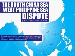
  • 3. Area of Maritime Space at Stake in Dispute
  • 4. The root cause of the South China Sea dispute is China’s 9-dashed lines claim, which gobbles up large areas of the EEZs and ECSs of the Philippines, Vietnam, Malaysia, Brunei and Indonesia. Root Cause of South China Sea Dispute
  • 5. China’s “National Boundaries” Gobble Up EEZs of Coastal States China’s 9-dashed lines claim encloses 85.7% of the entire South China Sea. This is equivalent to 3 million square kilometers out of the 3.5 million square kilometers surface area of the South China Sea.
  • 6. Nine-dashed Lines Map Submitted by China to United Nations on 7 May 2009 China did not explain the legal basis for the dashes. The dashes had no fixed coordinates. The Philippines, Vietnam, Malaysia and Indonesia protested China’s claim under this 9-dashed lines map.
  • 7. “China has indisputable sovereignty over the islands in the South China Sea and the adjacent waters, and enjoys sovereign rights and jurisdiction over the relevant waters as well as the seabed and subsoil thereof.” - China’s Note Verbale The terms “adjacent” and “relevant” waters are not UNCLOS terms. China refuses to explain the meaning of “adjacent” or “relevant” waters. Do these terms mean that China claims all the waters and resources enclosed by the 9-dashed lines? We shall examine China’s acts, regulations, declarations, and practices in the South China Sea to understand what China means by its 9-dashed lines claim, and how China interprets and applies the terms “adjacent” and “relevant” waters. China’s 2009 Note Verbale Explaining The 9-dashed Lines Map
  • 8. China Seized Subi Reef in 1988 In 1988, China seized Subi Reef from the Philippines by erecting a radar structure and military facilities on the reef. Subi Reef is a Low-Tide Elevation (LTE) outside of the Philippines’ EEZ but within its extended continental shelf (ECS). Subi Reef is just outside the 12 NM territorial sea of the Philippine-occupied Pagasa (Thitu) Island. Under UNCLOS, only the Philippines can erect structures or create an artificial island on Subi Reef. The waters of Subi Reef are part of the high seas of the South China Sea.
  • 9. China Seized Mischief (Panganiban) Reef in 1995 In 1995, China seized Mischief Reef from the Philippines. Mischief Reef, located 125 NM from Palawan, is a Low-Tide Elevation (LTE) within the Philippines’ EEZ. As an LTE beyond the territorial sea of any state, it is part of the submerged continental shelf of the adjacent coastal state, which is the Philippines. Under UNCLOS, only the Philippines can exploit its natural resources or erect structures on it.
  • 10. China Claimed Reed Bank in 2010 In February 2010, the Philippines awarded a Service Contract to Sterling Energy (predecessor of Forum Energy) for Block SC 72 in the Reed Bank. China protested, sending a Note Verbale to the Philippines on 22 February 2010, "express[ing] its strong objection and indignation,” and asserting "indisputable sovereignty, sovereign rights and jurisdiction over the Nansha Islands (Spratlys) and its adjacent waters.” China demanded that the Philippines "withdraw the Service Contract immediately.” China sent another Note Verbale on 13 May 2010 again demanding that the Philippines "immediately withdraw the decision to award the Service Contract” to Sterling Energy. Block SC 72 is 85 NM from Palawan, well within the Philippines’ EEZ, and 595 NM from Hainan.
  • 11. China Interfered Directly with a Philippine Service Contractor for Reed Bank in 2010 On 2 August 2010, the Nido Petroleum office in Manila received an email directly from the Chinese Embassy in Manila. The Embassy requested a meeting between the Chinese First Secretary and the Nido vice-president. The meeting was held on 6 August 2010. The Chinese First Secretary showed the Nido vice-president a map depicting China's 9-dashed lines, and informed him that the area covered by Nido Petroleum’s service contract (Block SC 58) was "claimed by" the People’s Republic of China. Since then Nido Petroleum has not made any exploration within Block SC 58. [Memorandum from Rafael E. Seguis, Undersecretary for Special and Ocean Concerns, Department of Foreign Affairs, Republic of the Philippines, to the Secretary of Foreign Affairs of the Republic of the Philippines (30 July 2010); Letter from Mr. Anthony P. Ferrer, Country Representative, Nido Petroleum, to the Office of the Undersecretary, Department of Energy of the Republic of Philippines (7 Oct. 2013)] Nido Exploration Area
  • 12. China Reiterated its Claim to Reed Bank in 2011 In 2011, the Philippines invited bids for the exploration of Area 3 and Area 4 in the Reed Bank, well within the Philippines’ EEZ. On 4 July 2011, China protested and sent a Note Verbale to the Philippines, stating: “The Chinese government urges the Philippine side to immediately withdraw the bidding offer in Areas 3 and 4, refrain from any action that infringes on China's sovereignty and sovereign rights.”
  • 13. Chinese Coast Guard Vessels Harassed A Philippine Survey Ship in Reed Bank in 2011 In March 2011, two Chinese coast guard vessels, the CMS-71 and CMS-75, prevented a Philippine-commissioned ship, the MV Veritas Voyager, from undertaking oil and gas survey in the Reed Bank, which is entirely within the Philippines’ EEZ. The 9-dashed lines cut through Malampaya, the Philippines’ largest operating gas field which supplies 40% of the energy requirement of Luzon. Malampaya will run out of gas in 10-12 years.
  • 14. In 2012, China invited an international bidding for the exploration of areas within the EEZ of Vietnam. China published this map, naming it “Location for part of open blocks in waters under jurisdiction of the People’s Republic of China available for foreign cooperation in the year of 2012.” China Auctioned off Areas within Vietnam’s EEZ & ECS
  • 15. In 2013, China released a new map of China, adding a 10th dash on the eastern side of Taiwan. In its 2013 map, China claims the 10-dashed lines are its “national boundaries,” without again explaining the legal basis or giving the fixed coordinates for the dashes. The 2013 China map was published by SinoMaps Press, under the jurisdiction of China’s State Bureau of Surveying and Mapping. This means the 2013 Map is an official Chinese government map. In its Note Verbale of June 7, 2013 to China, the Philippines stated it "strongly objects to the indication that the nine-dash lines are China's national boundaries in the West Philippine Sea/South China Sea.” China’s claim that the 9-dashed lines are China’s “national boundaries” contradicts its assurance to the world that there is “freedom of navigation and overflight in the South China Sea in accordance with international law.” China’s 2013 Map with 10-dashed Lines As “National Boundaries”
  • 16. China Claims 10-dashed Lines in 2013 Map Are China’s “National Boundaries”
  • 17. James Shoal - China’s “Southernmost” Border Since at least 2012, China has been periodically laying sovereignty steel markers on the seabed of James Shoal. China claims James Shoal as its southernmost border. James Shoal is fully submerged at 22 meters below the water surface, and is situated more than 950 NM from Hainan Island and more than 400 NM from Itu Aba. Under UNCLOS, the maximum maritime zone that a state can claim is 350 NM from baselines along its coast (or 100 NM from the 2500m isobath, a limitation which does not apply to China based on the geology of the South China Sea). Under international law, a state’s border must either be a land territory, a river, or a territorial sea - which are all subject to its full sovereignty. A state cannot appropriate as its sovereign territory a fully submerged area beyond its territorial sea. James Shoal is 80 KM from Malaysia’s coast in Bintulu, Sarawak, within Malaysia’s EEZ.
  • 18. China Holds Sovereignty Oath Swearing Ceremony at James Shoal in January 2014 A Chinese taskforce composed of three warships from the South China Sea Fleet of the Navy of the Chinese People’s Liberation Army (PLAN) held a sovereignty oath-swearing ceremony on January 26, 2014 in the waters of James (Zengmu) Shoal off the coast of Sarawak, Borneo in the South China Sea. The Singapore Straits Times quoted China’s Foreign Ministry spokesman Qin Gang that Malaysia did not lodge any protest against China. Photo: Xinhua
  • 19. China Seized Scarborough (Panatag) Shoal in 2012 In 2012, China seized Scarborough Shoal from the Philippines. In November 2012, following a three-month standoff between Philippine and Chinese vessels around the shoal, China informed the Philippines that Chinese coast guard vessels would remain permanently on the shoal. Scarborough Shoal, including its lagoon, has an area of 58 square miles or 150 square KMs (15,000 hectares). Located 124 NM from Zambales, Scarborough Shoal is rich in fisheries and is one of the traditional fishing grounds of Filipino fishermen. The shoal is a high tide elevation, with the biggest rock protruding 1.2 meter above water at high tide. China claims that Scarborough Shoal generates a 200 NM EEZ.
  • 20. China Seized Luconia Shoals in 2013 In 2013, China seized Luconia Shoals from Malaysia. Malaysian National Security Minister Shahidan Kassim posted on Facebook last June 4, 2015 the location map of Luconia Shoals, 54 NM from Sarawak, with this statement: "This small island is not a disputed territory but the foreign ship which came here has intruded into our national waters.” That foreign ship is the Chinese Coast Guard vessel Haijing 1123, which anchored on Luconia Shoals since April 2013 and has remained there up to now. Luconia Shoals, covering 100 square miles, are one of the largest reef formations in the South China Sea. Luconia Shoals, with a sandbar above water at high tide, are rich in fish, oil and gas. China claims that all geologic features in the Spratlys generate a 200 NM EEZ.
  • 21. China Installed HD 981 Oil Rig in 2014 In 2014, China placed its $1 billion deep-water HD 981 oil rig 130 NM from Vietnam’s coast, well within Vietnam’s EEZ. In protest, Vietnamese workers in export processing zones in Vietnam rioted, burning several Chinese factories. A Vietnamese fishing boat sank near the oil rig after being rammed by a Chinese vessel. Recent reports reveal that China is building three (3) more type HD 981 rigs for deployment in the South China Sea.
  • 22. Article 35 of the Hainan Province’s 2014 Fishery Regulations, which took effect on January 1, 2014, mandate that foreign fishing vessels “entering the waters under the jurisdiction of this province (Hainan) to engage in fishery operations or fishery resource surveys shall secure approval from relevant departments of the State Council.” The Fishery Regulations apply to Macclesfield Bank, which is part of the high seas. Hainan’s 2014 Fishery Regulations
  • 23. Waters Hainan Claims under its Administration The enclosed waters under Hainan’s administration comprise 2 million square kilometers out of the 3.5 square kilometers total surface area of the South China Sea. China claims a total of 3 million square kilometers or 85.7% of the waters of the South China Sea. Macclesfield Bank, which is part of the high seas, is within the enclosed waters.
  • 24. Since 1999, China thru Hainan Province has imposed unilaterally a three-month annual fishing moratorium, from mid-May to end July, on waters in and around the Paracels, Macclesfield Bank and Scarborough Shoal. Violators of the ban face fines, confiscation of fishing equipment, and even criminal charges. Macclesfield Bank is part of the high seas. In a Note Verbale dated 6 July 2015, China demanded that the Philippines “respect China's territorial sovereignty, sovereign rights and jurisdiction, and xxx educate its own fishermen, so that they can strictly abide by the fishing moratorium xxx." China warned that "Chinese law-enforcing authorities will strengthen their maritime patrols and other law-enforcing actions, investigate and punish the relevant fishing vessels and fishermen who violate the fishing moratorium xxx.” China Imposes a Unilateral Annual 3-Month Fishing Moratorium In the South China Sea
  • 25. The high seas have always been part of the global commons, whether before or after UNCLOS. The high seas could not be subject to sovereignty by any state, whether before or after UNCLOS. UNCLOS declares: “The high seas are open to all states, whether coastal or land-locked. Freedom of the high seas xxx comprises, inter alia, xxx freedom of fishing” (Art. 87, UNCLOS). UNCLOS declares: “No state may validly purport to subject any part of the high seas to its sovereignty” (Art. 89, UNCLOS). The High Seas Part of Global Commons
  • 26. By appropriating for itself the fishery resources in the high seas of the South China Sea, China is committing a grand theft of the global commons. All states, coastal and landlocked, are interested parties in the South China Sea dispute because China is appropriating for itself the fishery resources in the high seas. Grand Theft of the Global Commons
  • 27. All these acts of China, among so many others, demonstrate beyond doubt that China is claiming sovereignty, sovereign rights and jurisdiction to all the waters, fisheries, oil, gas, mineral resources, seabed and subsoil enclosed by the 9-dashed lines. The South China Sea - A Chinese Lake
  • 28. The Philippines loses about 80% of its EEZ facing the West Philippine Sea, including the entire Reed Bank and part of the Malampaya gas field. Malaysia loses also about 80% of its EEZ in Sabah and Sarawak facing the South China Sea, as well as most of its active gas and oil fields in the same area. Vietnam loses about 50% of its total EEZ. Brunei loses about 90% of its total EEZ. Indonesia loses about 30% of its EEZ facing the South China Sea in Natuna Islands, whose surrounding waters comprise the largest gas field in Southeast Asia. What is the Effect of China’s “National Boundaries” under the 9-dashed Lines?
  • 29. Philippines’ Sliver of Territorial Sea and EEZ The Philippines will be left with a sliver of water as its territorial sea and EEZ. The Philippines and China will have a very long common sea border – 1,300 kms – from Balabac Island in southern Palawan to Yamin Island in northern Batanes. The dashed lines are just 64 KMs from Balabac Island, 70 KMs from the coast of Burgos, Ilocos Norte, and 44 KMs from Yamin Island.
  • 30. Maritime Zones under UNCLOS An island above water at high tide is entitled to a 12 NM territorial sea. If such island is capable of human habitation or economic life of its own, it is entitled to a 200 NM EEZ. If there is a natural prolongation of its extended continental shelf, it is entitled to an ECS up to where the natural prolongation ends, but not exceeding 150 NM from the outer limits of its EEZ. The maximum maritime zone a coastal state can claim is 150 NM from the outer limits of its 200 NM EEZ (or 100 NM from the 2500 meter isobath, a limitation which does not apply to China based on the geology and geomorphology of the South China Sea). China is claiming maritime zones more than 150 NM from the outer limits of its EEZ.
  • 31. A Low-Tide Elevation (LTE) is a naturally formed area of land (rock, reef, atoll or sandbar) surrounded by water, above water at low tide but submerged at high tide. An LTE is part of the submerged continental shelf. An LTE is not land or territory, and has no territorial sea or territorial airspace (Art. 13, UNCLOS). An LTE beyond the territorial sea is not subject to appropriation by any State (Nicaragua v. Colombia, ICJ, 2012). Low-Tide Elevation (LTE)
  • 32. Low Tide Elevation vs. Rock/Island A low-tide elevation is not entitled to a territorial sea or any maritime zone. A rock above water at high tide is entitled to a 12 NM territorial sea. An island capable of human habitation or economic life of its own is entitled to a 12 NM territorial sea and a 200 NM EEZ, and if there is a natural prolongation of its extended continental shelf, it is entitled to an ECS up to the end of such natural prolongation but not exceeding 150 NM from the outer limits of its EEZ (or 100 NM from the 2500 meter isobath, if applicable).
  • 33. China has built artificial islands on seven (7) reefs: Fiery Cross Reef, Cuarteron Reef, Gaven Reef, Johnson South Reef, McKennan Reef, Mischief Reef and Subi Reef. These are all the reefs China occupies. However, China has actually also dredged ten (10) other reefs for filling materials for the seven reefs on which China has built islands.* China has explained: “The primary purpose of these activities is to improve the working and living conditions of personnel stationed there, to better fulfill our international obligations concerning maritime search and rescue, disaster prevention, and mitigation, and to enable China to provide better services to vessels from China, her neighbors, and other countries sailing in the South China Sea.”** * J. Ashley Roach, an ASIL member, Captain, JAGC, USN (retired), Office of the Legal Adviser, U.S. Department of State (retired), and Global Associate and Senior Visiting Scholar at the Centre for International Law (CIL) (2014–2015), National University of Singapore; see http://english.vietnamnet.vn/fms/marine-sovereignty/ 137126/china-s-shifting-sands-in-the-spratlys.html **Statement of Wang Min, China's deputy permanent representative to the United Nations. China’s Island-Building in the Spratlys
  • 34. China’s Island-Building on Seven Reefs There are about 750 small maritime features in the Spratlys. The vast majority are submerged at all times while others are exposed only at low tide. There are, at most, only 28 features that remain above water at high tide. The largest high-tide feature, Itu Aba, is only 0.43 square kilometer. The rest range in size from a high of 0.36 square kilometers (Pagasa) to a low of less than 2 square meters.
  • 35. Fiery Cross (Kagitingan) Reef Before Island-Building Fiery Cross Reef is about 1 meter above water at high tide. It is just outside the Philippines’ EEZ but within its continental shelf. In 1987, UNESCO agreed that China would build a weather station on Fiery Cross Reef as part of UNESCO’s global oceanic survey. That weather station would later turn out to be a Chinese military air and naval base. China’s Airbase with Seaport on Fiery Cross Reef Source: China State Shipbuilding Corporation One of the islands built by China is an airbase with a seaport, completed in June 2015. The airbase, with a 3,000 meter runway, is on a 274-hectare area on Fiery Cross Reef, larger than 213-hectare Woody Island which hosts China’s airbase in the Paracels. This artificial island will also be larger than the combined area of the 20 largest islands in the Spratlys, and more than twice the area of Diego Garcia Island, the U.S. airbase in the Indian Ocean.
  • 36. June 2015 Chinese Photo of Completed Island-Building on Fiery Cross Reef - 274 Hectare Airbase With 3 KM Runway As Admiral Harry Harris, commander of the U.S. Pacific Command stated, “A 10,000-foot (3 KM) runway is large enough to take a B-52, almost large enough for the Space Shuttle, and 3,000 feet longer than what you need to take off a 747.” Admiral Harris also stated that China is building on Fiery Cross Reef hangars for tactical fighters.
  • 37. China’s Strategic Bomber H-6K with 7,000 KM Range The H-6K can carry under its wing pylons six conventional or nuclear armed CJ-10A cruise missiles with 2,200 KM range. Although the H-6 was first domestically produced in 1968, this upgraded version, using composite materials, modern avionics and a powerful radar, first entered service only in October 2009.
  • 38. Test Flights on Fiery Cross Reef Runway - January 6, 2016
  • 39. Johnson South (Mabini) Reef Before Island-Building Johnson South Reef is an LTE within the Philippines’ EEZ. [Note: Chinese, Philippine and other countries’ nautical charts designate this as an LTE. Only the U.S. nautical chart designates this as a high tide feature.]
  • 40. Johnson South (Mabini) Reef December 26, 2015 In 1988, Chinese naval forces forcibly dislodged the Vietnamese soldiers guarding this LTE. Over 77 Vietnamese soldiers died in the battle. Johnson South Reef is within the Philippines’ EEZ. As of November 2015, China has created an artificial island of 10.9 hectares in Johnson South Reef.
  • 41. McKennan (Chigua) Reef Before Island-Building McKennan Reef is an LTE within the Philippines’ EEZ. It is within 12 NM of Sin Cowe Island.
  • 42. McKennan (Chigua, Hughes) Reef May 5, 2015 As of November 2015, China has created an artifical island of 7.2 hectares in McKennan Reef.
  • 43. Gaven (Burgos) Reef at Start of Island-Building Gaven Reef is outside of the Philippines’ EEZ but within its continental shelf. Gaven Reef is an LTE within 12 NM of Namyit Island.
  • 44. Gaven Reef May 9, 2015 As of November 2015, China has created an artificial island of 13.6 hectares in Gaven Reef.
  • 45. Cuarteron (Calderon) Reef Before Island-Building Cuarteron Reef is outside the Philippines’ EEZ but within its continental shelf. It is above water at high tide.
  • 46. Cuarteron Reef May 7, 2015 Cuarteron Reef is a tiny rock above water at high tide just outside the Philippines’ EEZ. As of November 2015, China has added 24.6 hectares to Cuarteron Reef.
  • 47. Subi (Zamora) Reef Before Island-Building Subi Reef is an LTE outside of the Philippines’ EEZ but within its continental shelf. Subi Reef is just outside the 12-NM territorial sea of the 36-hectare Pagasa (Thitu) Island, the largest island occupied by the Philippines in the Spratlys. Subi Reef is 231 NM from Palawan and 502 NM from Hainan.
  • 48. Subi (Zamora) Reef December 23, 2015 3 km runway/air strip
  • 49. Center Portion of Subi Reef Runway December 21, 2015 Source:www.ft.com
  • 50. Subi (Zamora) Reef January 8, 2016 Source:www.+.com Under UNCLOS, Subi Reef, an LTE in the high seas, cannot be used as a military facility. Article 88 of UNCLOS mandates that “the high seas shall be reserved for peaceful purposes.” The total area of Subi Reef, including the lagoon and rim of the reef, is 16 sq. km. In its original state, the Subi Reef‘s lagoon was 22 meters deep. Subi Reef’s location, size and depth make it ideal for a naval base with an airfield. As of December 23, 2015, China has created an artificial island of 500 hectares in Subi Reef.
  • 51. Mischief (Panganiban) Reef January 2012 and March 2015 Mischief Reef is a circular atoll with a diameter of 7.4 KM, and its lagoon has an area of 3,600 hectares. The average depth inside the lagoon is 26 meters. As of November 2015, China has created an artificial island of 590 hectares out of a planned 800 hectares. China can garrison thousands of troops on Mischief Reef. Mischief Reef is 125 NM from Palawan and 596 NM from Hainan.
  • 52. Mischief (Panganiban) Reef December 24, 2015 3 Km runway/air strip
  • 53. Mischief (Panganiban) Reef January 8, 2016 The northwest side of Mischief Reef as of January 8, including a 1,900 foot seawall and newly-constructed infrastructure including housing, an artificial turf parade grounds, cement plants, and docking facilities. - Source: www.ft.com
  • 54. Mischief Reef and Palawan, 125 NM Distance Mischief Reef is an LTE that is 125 NM from Palawan, well within the 200 NM EEZ of the Philippines. As an LTE, Mischief Reef is part of the submerged continental shelf of the Philippines. With an air and naval base in Mischief Reef between Palawan and all the Philippine-occupied islands in the Spratlys, China can block Philippine ships re-supplying Philippine-occupied islands in the Spratlys.
  • 55. China’s island-building violates the 2002 Asean- China Declaration of Conduct, which states that the parties undertake to exercise self-restraint, like “refraining from action of inhabiting on presently uninhabited islands, reefs, shoals, cays and other features.” Island-Building Violates the Declaration of Conduct
  • 56. China’s New Airbase on Woody Island, the Paracels Woody Island has an area of 213 hectares. It has a a 2,700 meter runaway that can handle all of China’s 4th generation fighter aircraft as well as the H-6K strategic bomber.
  • 57. An ADIZ in the South China Sea? China conducted in June 2015 its first air-sea military drill in the Bashi Channel between Taiwan and the Philippines. China announced that in the future it would conduct regular air-sea military drills in the Bashi Channel.
  • 58. China is mass-producing destroyers, frigates, corvettes and other warships at a faster rate than any other country in world history during peacetime. According to the U.S. Office of Naval Intelligence, “During 2014 alone, more than 60 naval ships and crafts were laid down, launched, or commissioned, with a similar number expected through the end of 2015.” China’s Continuing Mass Production of Warships
  • 59. China’s Type 056 Corvette China launched its 25th Type 056 Corvette last March 19, 2015, out of a total planned 40 Type 056 Corvette fleet. The PLA Navy believes that it can control the South China Sea with 20 of these Corvettes.
  • 60. China’s Second Navy - The Coast Guard China will deploy this year a 10,000-ton coast guard vessel, the world’s largest blue water coast guard vessel. A second 10,000-ton sister ship is under construction. China has more coast guard vessels than Japan, Vietnam, Indonesia, Malaysia and the Philippines combined. China’s Coast Guard is the largest blue water coast guard fleet in the world.
  • 61. 2015 China Military Strategy Under its 2015 “China Military Strategy,” China will shift from “offshore waters defense” to the combined “offshore waters defense” and “open seas protection.” The CMS states: “The traditional mentality that land outweighs the sea must be abandoned, and great importance has to be attached to managing the seas and oceans and protecting maritime rights and interests.”
  • 62. China’s Creeping Expansion in the SCS from 1946 to 2016 Before World War II, China’s southernmost defense perimeter was Hainan Island. Before the war, China did not have a single soldier or sailor stationed in any SCS island outside of Hainan Island. Right after the war, China took over the Amphitrite Group of the Paracels and Itu Aba in the Spratlys following the defeat of the Japanese, moving China’s defense perimeter southward. In 1974, China forcibly dislodged the South Vietnamese from the Crescent Group of the Paracels. In 1988, China forcibly evicted Vietnam from Johnson South Reef, moving further south China’s defense perimeter in the Spratlys. In 1995, China seized Mischief Reef from the Philippines, just 125 NM from Palawan and 594 NM from Hainan. In 2012, China seized Scarborough Shoal from the Philippines, just 124 NM from Luzon. In 2013, China seized Luconia Shoals from Malaysia, just 54 NM from Sarawak’s coast. In 2014, China started island-building on rocks and submerged areas in the Spratlys to construct air and naval bases.
  • 63. China’s grand design is to control the South China Sea for economic and military purposes. China wants all the fisheries, oil, gas and mineral resources within the 9- dashed lines. China already takes 50% of the annual fish catch in the South China Sea as more than 80% of its coastal waters are already polluted. China has the largest fishing fleet in the world with 70,000 vessels. China’s per capita fish consumption is the highest in the world at 35.1 kg/year to feed 1.4 billion people, while the rest of Asia’s per capita consumption is only 21.6 kg/year. China is the largest net importer of petroleum in the world. The South China Sea is rich in methane hydrates - said to be one of the fuels of the future. China wants to secure all these methane hydrates for itself. China also wants the South China Sea as a sanctuary for its nuclear-armed submarines – free from surveillance by U.S. submarine-hunting Poseidon airplanes or U.S. nuclear attack submarines. The island-building in the Spratlys is not a knee-jerk response to the Philippines’ arbitration case but part of China’s long-term grand design. As Zang Jie, head of the Asia Pacific Security program at the government-linked Chinese Academy of Social Sciences, stated: “China has wanted to do this for a long time. Now it has the dredging boats, the money and the people. So it is doing it.” China’s Grand Design in the South China Sea
  • 64. Mischief Reef - A 30-Million Year Work of Nature It takes 30 million years for the reefs of an atoll like Mischief Reef to form. Reefs are the breeding ground of fish. In the Spratlys, the eggs and larvae spawned by fish are carried by currents to the Sulu Sea, the coasts of Palawan, Luzon, Malaysia, Brunei, Indonesia, Vietnam and even China. All the reefs in the seven built-up sites of China are now dead. Reefs need clear waters to grow. Island- building makes the waters in nearby reefs turbid, unhealthy for both reefs and fish. The coral reefs in the South China Sea comprise 34% of the world’s total coral reefs, despite the South China Sea occupying only 2.5% of world’s total ocean surface.
  • 65. Chinese Reef Killer Dredges 4,500 Cubic Meters of Sand per Hour The Tiang Jing Hao (Heavenly Whale) dredger, a 127 meter-long seagoing cutter suction dredger designed by the German engineering company Vosta LMG. At 6,017 gross tons, this dredger is the largest in Asia. China has dozens of dredgers in the Spratlys.
  • 66. How Dredging Is Done in the Spratlys Coral reef and hard sediment on the seabed are pulverized by the rotating cutter. Pulverized materials are sucked into the ship. Pulverized materials are transported by pressure through a floating pipe. Pulverized materials are deposited on the rim of the reef.
  • 67. Fiery Cross Reef January 28, 2015 According to Dr. John McManus, a renowned marine biologist who has studied the marine life in the Spratlys, China’s island-building is the “most rapid permanent loss of coral reef in human history. It’s a terrible, terrible thing to do this.”
  • 68.
  • 69. Only the adjacent coastal state has the right to create artificial islands, or erect structures on LTEs, within its EEZ or ECS (Arts. 60 & 80, UNCLOS). Thus, such artificial islands or structures put up by other states within the EEZ or ECS of a coastal state are illegal under UNCLOS. Who can create artificial islands, or erect structures on LTEs, in the EEZ or ECS?
  • 70. Thus, Article 60, Part VI of UNCLOS, on “Artificial islands, installations and structures in the exclusive economic zone,” states: “1. In the exclusive economic zone, the coastal State shall have the exclusive right to construct and to authorize and regulate the construction, operation and use of: (a) artificial islands; (b) installations and structures for the purposes provided in Article 56 (exploitation of non- living resources in the seabed, marine scientific research, protection and preservation of marine environment) and other economic purposes; (c) xxx.” “2. The coastal state shall have exclusive jurisdiction over such artificial islands, installations and structures, including jurisdiction with regard to customs, fiscal, health safety and immigration laws and regulations.”
  • 71. Article 80, Part VI of UNCLOS, on “Artificial islands, installations and structures on the continental shelf,” states: “Article 60 applies mutatis mutandi to artificial islands, installations and structures on the continental shelf.” Clearly, China’s island-building on LTEs in the EEZ and ECS of the Philippines violate UNCLOS and are thus illegal under international law.
  • 73. No. UNCLOS defines an island as a “naturally formed” area of land, surrounded by water, and above water at high tide. (Art. 121, UNCLOS) Article 60(8) of UNCLOS provides: “8. Artificial islands, installations and structures do not possess the status of islands. They have no territorial sea of their own, and their presence does not affect the delimitation of the territorial sea, the exclusive economic zone, or the continental shelf.” Article 2(2) of UNCLOS states that “sovereignty extends to the air space over the territorial sea.” While a coastal state’s artificial structure installed within its own EEZ is entitled to 500-meter safety zone (Article 60(5), UNCLOS), an illegally installed structure by another state is not entitled to this legal 500-meter safety zone. A legal right cannot arise from an illegal act. Do LTEs and artificial islands acquire a maritime zone if by island-building they are raised above water at high tide ?
  • 74. Historic rights cannot be invoked to claim natural resources in the EEZ of another state. UNCLOS granted to coastal states “sovereign rights” to exploit its EEZ. “Sovereign rights” means supreme rights, superior to the rights of other states. This extinguished all historic rights or claims by other states in the EEZ of a coastal state. The word “exclusive” in the term EEZ means the economic exploitation of the zone is exclusive to the adjacent coastal state. China actively participated in the negotiations of UNCLOS from 1973 to 1982. China aligned itself with the developing coastal countries which demanded a 200 NM EEZ where the coastal state has exclusive sovereign rights to exploit the EEZ. China never claimed that historic rights could be an exception to the exclusive sovereign rights of coastal states in the EEZ. In fact, the 200 NM EEZ was agreed upon on the clear understanding that all historic claims of other states in the EEZ of a coastal state are deemed extinguished. Can a state claim “historic rights” in the EEZ of another state?
  • 75. “The rights of a coastal state over the continental shelf do not depend on occupation, effective or notional, or on any express proclamation” (Art. 77(3), UNCLOS). As the ICJ has explained, the rights of a coastal state “exist ipso facto and ab initio, by virtue of its sovereignty over the land.”* “[I]f the coastal state does not explore the continental shelf or exploit its natural resources, no one may undertake such activities without the express consent of the coastal state” (Art. 77[2]). This is an express prohibition to the application of historic rights claimed by other states in the continental shelf of another coastal state. The continental shelf of a state covers its EEZ and extended continental shelf. *North Sea Continental Shelf Cases (Federal Republic of Germany v. Denmark; Federal Republic of Germany v. Netherlands), Judgment, ICJ Reports 1969, paragraph 19. A Coastal State Has Inherent Right to its Continental Shelf
  • 76. Historic rights cannot be claimed in the EEZ, ECS or high seas. Even assuming, quod non, historic rights can be claimed, the following conditions must first be satisfied for historic rights to be valid: First, the state actually exercised authority over the area where it claims historic rights; Second, the state exercised that authority continuously and for a long period of time; and Third, other states either acquiesced in or failed to oppose the exercise of such authority.* China’s 9-dashed lines claim fail to satisfy any of these conditions. *United Nations Secretary General, Juridical Regime of Historic Waters, Including Historic Bays, UN Doc No. A/CN.4/143 (9 Mar. 1962), paragraph 80. Historic Rights under General International Law
  • 77. Compilation of Historical Archives on the Southern Territories of the Republic of China - Published in July 2015 by Taiwan This is a compilation of the most important documents relating to the 9-dashed lines culled from the thousands of records in the Kuomintang historical archives. The Kuomintang brought the records with them to Taiwan when they fled the mainland in 1949.
  • 78. The Tribunal invited the Philippines to comment on Taiwan’s official publication entitled Compilation of Historical Archives on the Southern Territories of the Republic of China published in July 2015. The Philippines made the following comments, among others: 1.  Of the tens of thousands of historical records reviewed by the experts who compiled the archives, not a single document could be identified asserting China’s claim to the South China Sea before 1907. 2.  Taiwan’s President Ma himself wrote in the Preface of the book that China’s "sovereignty over the South China Sea islands" dates only to the "early 20th century,” 1935 to be exact, with the publication of the Map of the South Sea Islands and Maritime Features. The claim to sovereignty refers only to the islands and their territorial seas. 3.  The book contains a timeline of key events that summarizes China's historic evidence in support of its historic rights claim. The chronology of event starts in 1907. 4.  The events in the timeline from 1907 to 1935 refer to China’s claims to the Pratas and the Paracels, not to the Spratlys. Chinese claims to the Spratlys started only in 1935. Kuomintang’s Compilation of Historical Archives
  • 79. Timeline of Key Events Starts in 1907
  • 80. In its Position Paper dated 7 December 2014 submitted to the UNCLOS Tribunal, China made this incredulous claim: “Chinese activities in the South China Sea date back to over 2,000 years ago. China was the first country to discover, name, explore and exploit the resources of the South China Sea Islands and the first to continuously exercise sovereign powers over them.” Taiwan’s publication of Compilation of Historical Archives on the Southern Territories of the Republic of China, using the extensive archives of the Kuomintang, the originator of the 9-dashed lines, has definitively debunked the PROC’s claim that the 9- dashed lines were “formed in the long course of history,” dating back two thousand years ago. Taiwan Debunked China’s Incredulous Historic Claim to the South China Sea
  • 81. 2002 ASEAN-China Declaration of Conduct The South China Sea dispute shall be resolved “in accordance with universally recognized principles of international law, including the 1982 UN Convention on the Law of the Sea.”
  • 82. After the Philippines filed in January 2013 its arbitration case against China under UNCLOS, China’s Foreign Minister Wang Yi declared that the South China Sea dispute should be resolved in accordance with “historical facts and international law.” China Insists on Respect for Historical Facts
  • 83. Official and unofficial maps of China from 1136 during the Song Dynasty until the end of the Qing Dynasty in 1912 show that the southernmost territory of China has always been Hainan Island. Official and unofficial maps of the Philippines from 1636 until 1933 show that Scarborough Shoal has always been part of the Philippines. The first name of Scarborough Shoal is “Panacot,” which appeared in the 1734 Murillo Velarde map published in Manila. Ancient Maps of China and the Philippines
  • 84. 1136 AD “Hua Yi Tu”
  • 85. 1896 “Huang Chao Zhi Sheng Yu Di Quan Tu” or The Qing Empire’s Complete Map of All Provinces. During the Chinese dynasties, Hainan Island was a part of Guangdong Province. Hainan became a separate province only in 1988.
  • 87. 1695 Coronelli Map of Southeast Asia This 1695 map, entitled Isole dell’ Indie, shows the Spratlys as part of the Philippines. This map was created by the Venetian Vincenzo Coronelli, a Franciscan monk. The map was published in Venice in 1695. Coronelli, famous for his atlases and globes, became the Father General of the Franciscan Order. The Franciscans arrived in the Philippines in 1578.
  • 88. 1899 “Islas Filipinas, Mapa General Observatorio de Manila.” Published in 1899 in Washington, D.C. by the U.S. Coast and Geodetic Survey.
  • 89. When the Qing Dynasty ended in 1912, the Chinese republicans led by Dr. Sun Yat Sen established the Republic of China. The following provisions of five (5) Constitutions of the Republic of China state:
  • 90. Constitution of 1912 Article 3, Chapter 1, of the Provisional Constitution of the Republic of China of March 11, 1912 states: “The territory of the Republic of China is composed of 22 provinces, Inner and Outer Mongolia, Tibet and Qinghai.” As we have seen in the 1896 map of the Qing Dynasty, one of the 22 provinces is Guangdong, which includes Hainan Island as the southernmost territory of China. 1896 “Huang Chao Zhi Sheng Yu Di Quan Tu” or The Qing Empire’s Complete Map of All Provinces
  • 91. Article 3, Chapter 1 of the Constitution of the Republic of China of May 1, 1914 states: “The territory of the Republic of China continues to be the territory of the former empire.” The editorial comment in the Regulations of the Republic of China Concerning Rule over Tibet (1999) explains the words “former empire” as “referring to the Qing Dynasty.” Constitution of 1914
  • 92. Official Publication of PROC: Territory of Republic of China Is the Same as Territory of the Qing Empire, with Hainan Island as Southernmost Border All constitutional provisions cited are from an official publication of the People’s Republic of China entitled Regulations of the Republic of China Concerning Rule Over Tibet (China No. 2 History Archives, China International Press, January 1, 1999). “Former empire” means the Qing Dynasty Page 3 of the Regulations state:
  • 93. Article 3, Chapter 2, of the Constitution of the Republic of China of October 10, 1924 states: “The territory of the Republic of China continues to be the traditional territory.” The Constitution of the Republic of China of January 1, 1937 states: “The territory of the Republic of China continues to be the territory it owned in the past.” Article 4, Chapter 1 of the Constitution of the Republic of China of December 25, 1946 states: “The territory of the Republic of China shall be that encompassed by its traditional boundaries.” Constitutions of 1924, 1937 and 1946
  • 94. As late as 1932, China has been telling the world that its southernmost border was Hainan Island, but that Hainan Island included the Paracels. In a Note Verbale to the French Government on September 29, 1932 protesting the French occupation of the Paracels, the Chinese Government officially declared:
  • 95. “Note of 29 September 1932 from the Legation of the Chinese Republic in France to the Ministry of Foreign Affairs, Paris On the instructions of its Government, the Legation of the Chinese Republic in France has the honor to transmit its Government’s reply to the Foreign Ministry’s Note of 4 January 1932 on the subject of the Paracel Islands.” xxxx
  • 96. “xxx The eastern group is called the Amphitrites and the western group the Crescent. These groups lie 145 nautical miles from Hainan Island, and form the southernmost part of Chinese territory.” (Emphasis supplied) xxx [Source: Sovereignty over the Paracel and Spratly Islands, Monique Chemelier-Gendreau, Annex 10, Kluwer Law International, 2000]
  • 97. 1933 “Zhonghua Min Guo Fen Sheng Xin Tu” Despite Chinese maps that appeared in the 1930s and 1940s showing the Paracels as part of China, China’s Republican Constitutions of 1937 and 1946 still declared that its territory remained the same as the territory of the former empire.
  • 98. In a document entitled China’s Sovereignty Over Xisha and Zhongsha Islands Is Indisputable issued on January 30, 1980, China’s Ministry of Foreign Affairs officially declared that the Nanhai island that Guo Shoujing visited in 1279 was in Xisha or what is internationally called the Paracels, a group of islands more than 380 NM from Scarborough Shoal. China issued this official document to bolster its claim to the Paracels to counter Vietnam’s strong historical claims to the same islands. This Chinese official document, published in Beijing Review, Issue No. 7 dated February 18, 1980, states: China and Vietnam: Conflicting Claims over the Paracels
  • 99.
  • 100. “Early in the Yuan Dynasty, an astronomical observation was carried out at 27 places throughout the country. xxx According to the official History of the Yuan Dynasty, Nanhai, Gou’s observation point, was “to the south of Zhuya” and “the result of the survey showed that the latitude of Nanhai is 15°N.” The astronomical observation point Nanhai was today’s Xisha Islands. It shows that Xisha Islands were within the bounds of China at the time of the Yuan dynasty.” (Emphasis supplied)
  • 101. Screenshot from China’s Manila Embassy Website Huangyan Island was first discovered and drew into China's map in China's Yuan Dynasty(1271-1368AD). In 1279, Chinese astronomer Guo Shoujing performed surveying of the seas around China for Kublai Khan, and Huangyan Island was chosen as the point in the South China Sea.
  • 102. Gaocheng Observatory This 12.6 meter high stone observatory in Henan Province is the only extant astronomical observatory among the 27 that Guo Shoujing built during the Yuan Dynasty.
  • 103.
  • 104. What is the legal basis of the Philippines’ claim to Scarborough Shoal The 1898 Treaty of Paris between Spain and the United States drew a rectangular line wherein Spain ceded to the United States all of Spain’s territories found within the treaty lines. Scarborough Shoal lies outside of the treaty lines.
  • 105. However, two years later, in the 1900 Treaty of Washington, Spain clarified that it had also relinquished to the United States “all title and claim of title, which (Spain) may have had at the time of the conclusion of the Treaty of Peace of Paris, to any and all islands belonging to the Philippine Archipelago, lying outside the lines” of the Treaty of Paris. Thus, Spain ceded Scarborough Shoal to the United States under the 1900 Treaty of Washington (Treaty between Spain and the United States for Cession of Outlying Islands of the Philippines, signed November 7, 1900.).
  • 106. When the issue of whether Scarborough Shoal forms part of Philippine territory, Secretary Cordell Hull of the U.S. State Department stated in his Memorandum of July 27, 1938 to Harry Woodring, Secretary of War: Because of the absence of other claims, the shoal should be regarded as included among the islands ceded to the United States by the American-Spanish Treaty of November 7, 1900*… In the absence of evidence of a superior claim to Scarborough Shoal by any other government, the Department of State would interpose no objection to the proposal of the Commonwealth Government to study the possibilities of the shoal as an aid to air and ocean navigation. *Treaty of Washington; boldfacing supplied. Source: A CNA Occasional Paper, Philippine Claims in the South China Sea: A Legal Analysis, Mark E. Rosen, JD, LLM [citing François-Xavier Bonnet, The Geopolitics of Scarborough Shoal, available at www.irasec.com.] (2014) In 1938 the U.S. Had Already Determined Scarborough Shoal Is Part of Philippine Territory
  • 107. From 1960s to1980s, Scarborough Shoal was used by the American and Philippine military as an impact range for their warships and warplanes. Notices to Mariners were issued worldwide by American and Philippine authorities thru the International Maritime Organization of the United Nations whenever bombing runs were made. Not a single country registered any protest to these military activities.
  • 108. The Philippine Navy issued a Notice to Mariners on 18 September 1981 warning mariners that the U.S. Navy would undertake gunnery and bombing exercises in Scarborough Shoal. Source: Bajo de Masinloc, Maps and Documents, U.P. Institute for Maritime Affairs and Law of the Sea/NAMRIA, 2014 Bombing and gunnery exercise using live ammunition have taken place at 15 degrees 07 minutes North, 117 degrees 46 minutes East within 20 mile radius. The exercises are conducted more or less on a daily basis and likely to continue indefinitely. Philippine Navy Notice to Mariners in September 1981
  • 109. Bureau of Coast and Geodetic Survey, Notice to Mariners, February 24, 1983 Source: Bajo de Masinloc, Maps and Documents, U.P. Institute for Maritime Affairs and Law of the Sea/NAMRIA, 2014 The missile firing ranges are bound as follows: Vessels may be requested to alter course within the above areas due to firing operations and are requested to monitor VHF Channel 16, 500 KHZ o r o t h e r a p p r o p r i a t e m a r i n e broadcast frequencies for details of firing schedules before entering above areas. The Bureau of Coast and Geodetic Survey announces the following navigational warnings to all mariners and others concerned in surface navigation
  • 110. In September 2014, Taiwan’s President Ma Ying-jeou, who belongs to the Kuomintang Party, which controlled the Chinese mainland government in 1947 that adopted the 9- dashed lines, clarified the extent of China’s claim under the lines. President Ma declared that the claim was limited only to the islands and their adjacent 3 NM (now 12 NM) territorial sea. President Ma unequivocally stated that there were “no other so-called claims to sea regions.” This express clarification from Taiwan directly contradicts China’s claim that China has “indisputable sovereignty” over all the waters enclosed within the 9-dashed lines. Taiwan’s President Ma Ying-jeou Statement
  • 111. In an October 21, 2014 interview with the New York Times, President Ma, who earned an S.J.D. from Harvard University with specialty in the Law of the Sea, stated: “There is a basic principle in the Law of the Sea, that land dominates the sea. Thus marine claims begin with land; however, even if it is logically this way, when resolving disputes, it is not impossible to first resolve resource development issues. xxx.” President Ma Ying-jeou: A Law of the Sea Scholar
  • 112. Scarborough Shoal Why fight over rocks like Scarborough Shoal? What is the value of these rocks?
  • 113. As an island, Scarborough Shoal is entitled to a 12 NM territorial sea around it. This amounts to 155,165 hectares of maritime space, more than twice the land area of Metro Manila of 63,600 hectares. Scarborough Shoal
  • 115. Japan’s Okinotorishima Rock In Philippine Sea: Preventing Erosion of Tiny Rock This rock is about 7 inches above water at high tide. Japan reportedly spent US$600 million to prevent erosion in three Okinotorishima rocks.
  • 116. If UNCLOS does not apply to the South China Sea dispute, as when China’s 9-dashed lines are allowed to gobble up the EEZs of coastal states as well as the high seas, then UNCLOS, the constitution for the oceans and seas, cannot also apply to any maritime dispute in the rest of the oceans and seas of our planet. It will be the beginning of the end for UNCLOS. The rule of the naval cannon will prevail in the oceans and seas of our planet, no longer the rule of law. There will be a naval arms race among coastal countries. Why is it important to apply UNCLOS to the South China Sea dispute?
  • 117. The Philippines today is engaged in a historic battle to defend over 531,000 square kilometers of its maritime space (EEZ and ECS) in the West Philippine Sea, an area larger than the total land area of the Philippines of 300,000 square kilometers. This huge maritime space is part of Philippine national territory since the Constitution defines the “national territory” to include “the seabed, the subsoil, xxx and other submarine areas” over which the Philippines has “sovereignty or jurisdiction.” Under UNCLOS, the Philippines has “jurisdiction” over this huge maritime space. Can the Philippines prevent China from gobbling up this huge maritime space? All citizens of the Philippines - both government personnel and private individuals – have a solemn duty to prevent the loss of this huge maritime space. It is a duty we owe to ourselves, and to future generations of Filipinos. Conclusion: A Historic Battle
  • 118. End