SlideShare a Scribd company logo
1 of 74
Download to read offline
After the long vacation, when Ravi started going to school
again, he noticed that the only playground next to his school
was dug up. People said that a huge building with many
flats will be constructed there. Ravi was almost in tears,
when he realised that the big playground with its soft
grass, marigolds and butterflies is gone for ever. He shared
his feelings with his classmates. In the assembly, the
Principal too sadly observed, “See how our environment
is changing.”
In the class Ravi asked his teacher, “What is
environment?” “Whatever you see in your surroundings,”
said the teacher.
Ravi thought aloud, “That means, the school building,
tables, chairs in the classroom, even that open field, the
road, the garbage, my friends – all are parts of our
environment”!
“Yes” said the teacher, “but wait….. Some objects are
created by nature – for example, mountains, rivers, trees,
animals. Others are made by people – for example roads,
cars, clothes, books”.
Now work in pairs. Make a list with your classmate
sitting next to you, of the creations of nature and by
human beings.
Environment is our
basic life support
system. It provides
the air we breath, the
water we drink, the
food we eat and the
land where we live.
How do human
beings modify this
natural environment?
The car fumes pollute
the air, water is
collected in a pot,
food is served in
vessels and land is
used to build
factories.
Human beings
make cars, mills,
factories and
manufacture
containers. This is
how human beings
modify natural
environment.
1Environment
Ravi, Paramjeet, Jessy, Mustafa, Asha were all excited
about making the list. “Why is our environment changing?”
asked Iqbal. “It’s all because of our needs. They are
2020-21
2 OUR ENVIRONMENT
Natural
Human
made
Human
made
Human
Components
of
Environment
Water
(Hydrosphere)
Air
(Atmosphere)
Land
(Lithosphere)
Living Things
(Biosphere)
Parks
Buildings
Bridges
Roads
Industries Monuments
Individual
Family
Community
Religion Educational
Economic
Political
Situation
Fig. 1.1: Components of Environment
increasing day by day; we are therefore modifying and
at times even destroying our natural surroundings”, the
teacher replied.
From the above conversation you
understand that the place, people, things and
nature that surround any living organism is
called environment. It is a combination of
natural and human made phenomena. While
the natural environment refers to both biotic
and abiotic conditions existing on the earth,
Biotic
The world of
living
organisms.
e.g. plants
and animals.
Abiotic
The world of
non-living
elements.
e.g. land.
2020-21
ENVIRONMENT 3
Let’s do
Fig. 1.2: Domains of the Environment
Hydrosphere
Lithosphere
Biosphere
Atmosphere
Let’s do
human environment reveals the activities, creations and
interactions among human beings.
NATURAL ENVIRONMENT
Land, water, air, plants and animals comprise the natural
environment. You are familiar with the meaning of
lithosphere, hydrosphere, atmosphere and biosphere
from your previous class. Let us learn some more facts
about these domains.
Lithosphere is the solid crust or the hard top layer of
the earth. It is made up of rocks and minerals and covered
by a thin layer of soil. It is an irregular surface with
various landforms such as mountains, plateaus, plains,
valleys, etc. Landforms are found over the continents
and also on the ocean floors.
Lithosphere is the domain that provides us forests,
grasslands for grazing, land for agriculture and human
settlements. It is also a source of mineral wealth.
Look at your
surroundings. Make a
list of uses that the
land in your
neighbourhood is
being put to.
Let’s do
Where does the water
you use in your home
and school come
from? Make a list of
different uses of
water in our daily life.
Have you seen anyone
wasting water? How?
Observe the sky while
coming to school.
Make a note whether
the day is cloudy,
rainy, sunny, foggy etc.
The domain of water is referred to as hydrosphere. It
comprises various sources of water and different types of
water bodies like rivers, lakes, seas, oceans, etc. It is
essential for all living organisms.
The atmosphere is the thin layer of air that
surrounds the earth. The gravitational force of the
earth holds the atmosphere around it. It protects us
Word Origin
Environment: French
word Environer/
Environner meaning
“neighbourhood”.
2020-21
4 OUR ENVIRONMENT
Glossary
Fig. 1.3: A Pond Ecosystem
from the harmful rays and scorching heat of the sun.
It consists of a number of gases, dust and water vapour.
The changes in the atmosphere produce changes in
the weather and climate.
Plant and animal kingdom together make biosphere
or the living world. It is a narrow zone of the earth
where land, water and air interact with each other to
support life.
What is ecosystem?
At an NCC camp that Ravi’s class was attending, Jessy
exclaimed, “What a heavy downpour. It reminds me of
my home in Kerala. You should come and see how it
pours and pours and pours over the lush green fields
and coconut plantations.”
Heera from Jaisalmer exclaimed, “We get no rains.
We see only ‘kikar’ and sand, as far as the eyes can
see.” “But you also find camels”, said Ravi.
Let’s do
Sketch or bring
photographs of your
place like the
students in the story.
Ecosystem: It is a
system formed by the
interaction of all
living organisms with
each other and with
the physical and
chemical factors of
the environment in
which they live, all
linked by transfer of
energy and material.
2020-21
ENVIRONMENT 5
Glossary
Let’s do
Barter System:
It is a trade in which
goods are exchanged
without the use of
money.
Talk to some elderly
person in your
neighbourhood and
collect information
about–
• The trees in his/
her neighbourhood
when he/ she was
your age.
• The indoor games
he/she played.
• His/her favourite
fruit at your age.
• How did they make
themselves
comfortable during
hot summers and
cold winters?
Display your answers
on a wall/bulletin
board.
Heera says, “Not just camels. If you visit our desert,
you will see snakes, lizards and many insects too.”
Ravi wondered, “Why do the animals, the vegetation
and the way people live vary from place to place? Are
they all related to each other?”
“Oh yes, very much so”, the teacher replied.
All plants, animals and human beings depend on
their immediate surroundings. Often they are also
interdependent on each other. This relation between the
living organisms, as well as the relation between the
organisms and their surroundings form an ecosystem.
There could be an ecosystem of large rain forest,
grassland, desert, mountains, lake, river, ocean and even
a small pond.
Do you think the park in which Ravi and his friends
played formed an ecosystem?
HUMAN ENVIRONMENT
Human beings interact with the environment and modify
it according to their need. Early humans adapted
themselves to the natural surroundings. They led a
simple life and fulfilled their requirements from the
nature around them. With time needs grew and became
more varied. Humans learn new ways to use and change
environment. They learn to grow crops, domesticate
animals and lead a settled life. The wheel was invented,
surplus food was produced, barter system emerged, trade
started and commerce developed. Industrial revolution
enabled large scale production. Transportation became
faster. Information revolution made communication
easier and speedy across the world.
Have you ever thought why you love eating a juicy
watermelon in summer and hot roasted peanuts in
winter? A perfect balance is necessary between the
natural and human environment. Humans must learn
to live and use their environment in a harmonious way.
Nurie, a girl from Mizoram from Ravi’s class often talks
about the lush green surroundings of her place. Seeing
Ravi upset at having lost his playground, Nurie invited
him to visit her home state during the coming vacation.
Ravi’s teacher asked the students to draw the landscape,
houses and activities of the people and places they visit
during the holidays.
Do you know?
On 5 June every year
the World Environment
Day is celebrated.
2020-21
6 OUR ENVIRONMENT
1. Answer the following questions.
(i) What is an ecosystem?
(ii) What do you mean by natural environment?
(iii) Which are the major components of the environment?
(iv) Give four examples of human made environment.
(v) What is lithosphere?
(vi) Which are the two major components of biotic environment?
(vii) What is biosphere?
2. Tick the correct answer.
(i) Which is not a natural ecosystem?
(a) Desert (b) Aquarium (c) Forest
(ii) Which is not a component of human environment?
(a) Land (b) Religion (c) Community
(iii) Which is a human made environment?
(a) Mountain (b) Sea (c) Road
(iv) Which is a threat to environment?
(a) Growing plant
(b) Growing population
(c) Growing crops
3. Match the following.
(i) Biosphere (a) blanket of air which surrounds the earth
(ii) Atmosphere (b) domain of water
(iii) Hydrosphere (c) gravitational force of the earth
(iv) Environment (d) our surroundings
(e) narrow zone where land water and air interact
(f) relation between the organisms and their surroundings
4. Give reasons.
(i) Man modifies his environment
(ii) Plants and animals depend on each other
5. Activity.
Imagine an ideal environment where you would love to live. Draw the picture of
your ideal environment.
Exercises
2020-21
The earth, our homeland is a dynamic planet. It is
constantly undergoing changes inside and outside. Have
you ever wondered what lies in the interior of the earth?
What is the earth made up of?
INTERIOR OF THE EARTH
Just like an onion, the
earth is made up of
several concentric
layers with one inside
another (Fig. 2.1). The
uppermost layer over
the earth’s surface is
called the crust. It is the
thinnest of all the
layers. It is about 35 km.
on the continental
masses and only 5 km.
on the ocean floors.
The main mineral
constituents of the
continental mass are
silica and alumina. It is
thus called sial (si-silica
and al-alumina). The
oceanic crust mainly
consists of silica and
magnesium; it is therefore
called sima (si-silica and
ma-magnesium) (Fig. 2.2).
Just beneath the crust
is the mantle which
extends up to a depth of
2900 km. below the crust.
2Inside Our Earth
Do you know?
• The deepest mine in
the world, is in
South Africa. It is
about 4 km. deep. In
search for oil
engineers have dug a
hole about 6 km.
deep.
• To reach to the
centre of the earth
(which is not
possible!) you will
have to dig a hole
6000 km. deep on
the ocean floor.
Crust
Lithosphere
Core-mantle
boundary
Mantle
Outer
core
Inner core
Fig. 2.1: Interior of the Earth
Continental
Crust
Fig. 2.2: Continental Crust and Oceanic Crust
Continent Ocean
Oceanic
Crust
2020-21
8 OUR ENVIRONMENT
Glossary
The innermost layer is the core with a radius of about
3500 km. It is mainly made up of nickel and iron and is
called nife (ni – nickel and fe – ferrous i.e. iron). The
central core has very high temperature and pressure.
ROCKS AND MINERALS
The earth’s crust is made up of various types of rocks.
Any natural mass of mineral matter that makes up the
earth’s crust is called a rock. Rocks can be of different
colour, size and texture.
There are three major types of rocks: igneous rocks,
sedimentary rocks and metamorphic rocks.
When the molten magma cools, it becomes solid.
Rocks thus formed are called igneous rocks. They are
also called primary rocks. There are two types of igneous
rocks: intrusive rocks and extrusive rocks.
Can you imagine lava coming out from the volcanoes?
Lava is actually fiery red molten magma coming out from
the interior of the earth on its surface. When this molten
lava comes on the earth’s surface, it rapidly cools down
and becomes solid. Rocks formed in such a way on the
crust are called extrusive igneous rocks. They have a
very fine grained structure. For example, basalt. The
Deccan plateau is made up of basalt rocks. Sometimes
the molten magma cools down deep inside the earth’s
crust. Solid rocks so formed are called intrusive igneous
rocks. Since they cool down slowly they form large
grains. Granite is an example of such a rock. Grinding
stones used to prepare paste/powder of spices and grains
are made of granite.
Rocks roll down, crack, and hit each other and are
broken down into small fragments. These smaller particles
are called sediments. These sediments are transported
and deposited by wind, water, etc. These loose
sediments are compressed and hardened to form
layers of rocks. These types of rocks are called
sedimentary rocks. For example, sandstone is
made from grains of sand. These rocks may also
contain fossils of plants, animals and other micro-
organisms that once lived on them.
Igneous and sedimentary rocks can change
into metamorphic rocks under great heat and
pressure (Fig. 2.3). For example, clay changes into
slate and limestone into marble.
Fig. 2.3: Sedimentary rock turned
into a Metamorphic rock
Fossils: The remains
of the dead plants and
animals trapped in
the layers of rocks are
called fossils.
Word Origin
Igneous: Latin word
Ignis meaning fire.
Sedimentary: Latin
word sedimentum
meaning settle down.
Metamorphic: Greek
word metamorphose
meaning change of form.
Do you know?
• The crust forms only
1 per cent of the
volume of the earth,
84 per cent consists
of the mantle and
15 per cent makes
the core.
• The radius of the
earth is 6371 km.
2020-21
INSIDE OUR EARTH 9
Let’s do
The Taj Mahal is made of white marble
The Red Fort is made of red sandstone
Collect pictures of some monuments and find out which are the rocks
used to build them. Two pictures have been collected for you.
Rocks are very useful to us. The hard rocks are used
for making roads, houses and buildings. You use stones
in many games. For example, seven stones (pitthoo), hop-
scotch (stapu/kit kit), five stones (gitti). Find out some
more such games by asking your grand parents, parents,
neighbours, etc.
You will be surprised to know that one type of rock
changes to another type under certain conditions in a
cyclic manner. This process of transformation of the rock
from one to another is known as the rock cycle. You
have already learnt when the
molten magma cools; it solidifies
to become igneous rock. These
igneous rocks are broken down
into small particles that are
transported and deposited to
form sedimentary rocks. When
the igneous and sedimentary
rocks are subjected to heat
and pressure they change
into metamorphic rocks. The
metamorphic rocks which are still
under great heat and pressure
melt down to form molten magma.
This molten magma again can
cool down and solidify into
igneous rocks (Fig. 2.4). Fig. 2.4: Rock Cycle
2020-21
10 OUR ENVIRONMENT
Let’s do
What are the
minerals found in
your state?
Collect some samples
to show in your class.
1. Answer the following questions.
(i) What are the three layers of the earth?
(ii) What is a rock?
(iii) Name three types of rocks.
(iv) How are extrusive and intrusive rocks formed?
(v) What do you mean by a rock cycle?
(vi) What are the uses of rocks?
(vii) What are metamorphic rocks?
2. Tick the correct answer.
(i) The rock which is made up of molten magma is
(a) Igneous (b) Sedimentary (c) Metamorphic
(ii) The innermost layer of the earth is
(a) Crust (b) Core (c) Mantle
(iii) Gold, petroleum and coal are examples of
(a) Rocks (b) Minerals (c) Fossils
(iv) Rocks which contain fossils are
(a) Sedimentary rocks
(b) Metamorphic rocks
(c) Igneous rocks
(v) The thinnest layer of the earth is
(a) Crust (b) Mantle (c) Core
3. Match the following.
(i) Core (a) Earth’s surface
(ii) Minerals (b) Used for roads and buildings
(iii) Rocks (c) Made of silicon and alumina
(iv) Clay (d) Has definite chemical composition
(v) Sial (e) Innermost layer
(f) Changes into slate
(g) Process of transformation of the rock
Rocks are made up of different minerals. Minerals
are naturally occurring substances which have certain
physical properties and definite chemical composition.
Minerals are very important to humankind. Some are
used as fuels. For example, coal, natural gas and
petroleum. They are also used in industries – iron,
aluminium, gold, uranium, etc, in medicine, in
fertilisers, etc.
Exercises
2020-21
INSIDE OUR EARTH 11
4. Give reasons.
(i) We cannot go to the centre of the earth.
(ii) Sedimentary rocks are formed from sediments.
(iii) Limestone is changed into marble.
5. For fun.
(i) What are the minerals most commonly used in the following objects?
(ii) Identify some more objects made up of different minerals.
Karhai Ornaments
Pan/Tava
Bell
Hammer
Lamp
2020-21
Activity
Take a small coloured
paper pellet and put it
in a beaker
half filled
with water.
Place the
beaker on a
tripod stand
and heat it. As the
water warms up, you
will observe that the
paper pellet is moving
upward along with the
warm layers of water
and then
sinks back
along with
the cooler
layers of water. The
molten magma inside
the earth moves in a
similar manner.
The lithosphere is broken into a number of plates known
as the Lithospheric plates. You will be surprised to know
that these plates move around very slowly – just a few
millimetres each year. This is because of the movement
of the molten magma inside the earth. The molten magma
inside the earth moves in a circular manner as shown in
the activity.
The movement of these plates causes changes on the
surface of the earth. The earth movements are divided
on the basis of the forces which cause them. The forces
which act in the interior of the earth are called as
Endogenic forces and the forces that work on the surface
of the earth are called as Exogenic forces (Fig. 3.1).
3 Our Changing Earth
Glossary
Lithospheric plates:
The earth’s crust
consists of several
large and some small,
rigid, irregularly-
shaped plates (slabs)
which carry
continents and the
ocean floor.
Fig. 3.1: Evolution of Landforms
Earth movements
Endogenic forces Exogenic forces
Sudden forces Diastrophic forces Erosional and Depositional
Building mountains
Earthquake
Volcano
Landslides
River
Wind
Sea-waves
Glaciers
Endogenic forces sometimes produce sudden movements
and at the other times produce slow movements. Sudden
movements like earthquakes and volcanoes cause mass
destruction over the surface of the earth.
2020-21
Crater
Lava
tube
Vent
Lava
Gases and ash
Crust
Mantle
Magma
Chamber
Word Origin
Fig. 3.2: A Volcano
Epicentre Seismic waves radiate
out in all directions
Plate boundary
Focus – this is where the
earthquake occurs. It is the
origin of the seismic energy
A volcano is a vent (opening) in the
earth’s crust through which molten
material erupts suddenly (Fig. 3.2).
Fig. 3.3: Origin of an Earthquake
Activity
Take a container, fill
it with water and
close it with a lid. Put
the water to boil. Now
put some peas, spoon
and beads on top on
the lid. What do you
notice? As the water
boils the lid begins to
shake. The things
which you have put
on the lid also
vibrate. The beads roll
down and the spoon
vibrates to make a
sound. In the same
manner, the earth
vibrates when an
earthquake occurs.
Do you know?
There are three types
of earthquake waves:
1. P waves or
longitudinal waves
2. S waves or
transverse waves
3. L waves or surface
waves
Try to find out the
properties of these
waves from an
encyclopedia.
Similarly, when the Lithospheric plates move, the
surface of the earth vibrates. The vibrations can travel
all round the earth. These vibrations are called
earthquakes (Fig. 3.3). The place in the crust where the
movement starts is called the focus. The place on the
surface above the focus is called the epicentre.
Vibrations travel outwards from the epicentre as waves.
Greatest damage is usually closest to the epicentre and
the strength of the earthquake decreases away from
the centre.
Endo
(inside)
Exo
(outside)
Endogenic
Exogenic
+ genic
(origin)
13
OUR CHANGING EARTH
.
2020-21
14 OUR ENVIRONMENT
Activity
Do you know?
An earthquake is
measured with a
machine called a
seismograph. The
magnitude of the
earthquake is
measured on the
Richter scale. An
earthquake of 2.0 or
less can be felt only a
little. An earthquake
over 5.0 can cause
damage from things
falling. A 6.0 or
higher magnitude is
considered very
strong and 7.0 is
classified as a major
earthquake.
A Seismograph
EARTHQUAKE PREPAREDNESS
Where to take shelter during an earthquake —
Safe Spot – Under a kitchen counter, table or desk,
against an inside corner or wall.
Stay Away from – Fire places, areas around chimneys,
windows that shatter including mirrors and picture
frames.
Be Prepared – Spread awareness amongst your friends
and family members and face any disaster confidently.
Fig. 3.3a: Destruction
caused by an Earthquake
in Gujarat
1. Read the ‘Earthquake – A case study’ given in the
form of headlines that appeared in the newspapers
after the quake. Arrange the events in the right
sequence of their happening.
2. Imagine if a quake suddenly shook in the middle of
the school day, where would you go for safety?
Although earthquakes cannot be predicted, the
impact can certainly be minimised if we are prepared
before-hand.
Some common earthquake prediction methods
adopted locally by people include studying animal
behaviour; fish in the ponds get agitated, snakes come
to the surface.
EARTHQUAKE HITS BHUJ
A massive earthquake measuring 6.9 on Richter
scale hit Bhuj Town on 26th January 2001.
Fire in the city
Hundreds of fires
started as charcoal,
cookers overturned.
Emergency declared
in quake zone
The President declares
a state of emergency.
Atleast 971 students
and 31 teachers are
feared to have lost
their lives following
the collapse of
school buildings.
School worst
affected
CM’S APPEAL TO THE CENTRE
Gujarat appeals for
financial help. The
Chief Minister of
Gujarat has launched
an appeal for the
Centre to deal with
the disaster.
Destruction of Bhuj
Phone lines, water
pipelines and power
stations transmission
lines were knocked out.
1
2 3
4
5
6
7
BHUJ RELIEF EFFORT
BLIGHTED..
Three days after the
quake, concern rose
about food, blankets
and medical supplies
not reaching everyone.
Earthquake – A Case Study
2020-21
15
OUR CHANGING EARTH
Fig. 3.5: Features made by a river in a flood plain
Do you know?
MAJOR LAND FORMS
The landscape is being continuously worn away by two
processes – weathering and erosion. Weathering is the
breaking up of the rocks on the earth’s surface. Erosion
is the wearing away of the landscape by different agents
like water, wind and ice. The eroded material is carried
away or transported by water, wind, etc. and eventually
deposited. This process of erosion and deposition create
different landforms on the surface of the earth.
Work of a River
The running water in the river erodes the landscape. When
the river tumbles at steep angle over very hard rocks or
down a steep valley side it forms a waterfall (Fig. 3.4).
• There are
thousands of small
waterfalls in the
world. The highest
waterfall is Angel
Falls of Venezuela
in South America.
The other waterfalls
are Niagara falls
located on the
border between
Canada and USA in
North America and
Victoria Falls on
the borders of
Zambia and
Zimbabwe in Africa.
The Niagra falls
Hard rock
Softer rock undercut
by the power of
the water
Fig. 3.4: Waterfall
As the river enters the plain it twists and turns forming
large bends known as meanders. Due to continuous
erosion and deposition along the sides of the meander,
the ends of the meander loop come closer
and closer. In due course of time the
meander loop cuts off from the river and
forms a cut-off lake, also called an ox-bow
lake. At times the river overflows its banks.
This leads to the flooding of the
neighbouring areas. As it floods, it
deposits layers of fine soil and other
material called sediments along its
banks. This leads to the formation
of a flat fertile floodplain. The raised
banks are called levees. As the river
approaches the sea, the speed of the
flowing water decreases and the
2020-21
16 OUR ENVIRONMENT
river begins to break up
into a number of streams
called distributaries. The
river becomes so slow that
it begins to deposit its load.
Each distributary forms its
own mouth. The collection
of sediments from all the
mouths forms a delta.
Work of Sea Waves
The erosion and deposition of
the sea waves gives rise to
coastal landforms. Seawaves
continuously strike at the
rocks. Cracks develop. Over
time they become larger and
wider. Thus, hollow like caves
are formed on the rocks. They
are called sea caves. As these
cavities become bigger and
bigger only the roof of the
caves remain, thus forming sea
arches. Further, erosion
breaks the roof and only walls
are left. These wall like features are called stacks.
The steep rocky coast rising almost vertically above
sea water is called sea cliff. The sea waves deposit
sediments along the shores forming beaches.
Work of Ice
Glaciers are “rivers of ice” which
too erode the landscape by
bulldozing soil and stones to
expose the solid rock below.
Glaciers carve out deep hollows
there. As the ice melts they get
filled up with water and become
beautiful lakes in the
mountains. The material carried
by the glacier such as rocks big
and small, sand and silt gets
deposited. These deposits form
glacial moraines.
Let’s do
Find out the names of
a few rivers of the
world that form a
delta.
Fig. 3.8: A Glacier
Main river Distributary
Fig. 3.6: A Delta
Sea Cave
Sea Arch
Stack
Fig. 3.7: Features made by sea waves
2020-21
17
OUR CHANGING EARTH
Work of wind
Have you ever visited a desert? Try to collect some
pictures of sand dunes.
An active agent of erosion and deposition in the deserts
is wind. In deserts you can see rocks in the shape of a
mushroom, commonly called mushroom rocks. Winds
erode the lower section of the rock more than the upper
part. Therefore, such rocks have narrower base and wider
top. When the wind blows, it lifts and transports sand
from one place to another. When it stops blowing the
sand falls and gets deposited in low hill – like structures.
These are called sand dunes (Fig. 3.9). When the grains
of sand are very fine and light, the wind can carry it over
very long distances. When such sand is deposited in
large areas, it is called loess. Large deposits of loess is
found in China.
Fig. 3.9: Sand Dunes
Exercises
1. Answer the following questions.
(i) Why do the plates move?
(ii) What are exogenic and endogenic forces?
(iii) What is erosion?
(iv) How are flood plains formed?
(v) What are sand dunes?
(vi) How are beaches formed?
(vii) What are ox bow lakes?
2. Tick the correct answer.
(i) Which is not an erosional feature of sea waves?
(a) Cliff (b) Beach (c) Sea cave
(ii) The depositional feature of a glacier is:
(a) Flood plain (b) Beach (c) Moraine
(iii) Which is caused by the sudden movements of the earth?
(a) Volcano (b) Folding (c) Flood plain
(iv) Mushroom rocks are found in:
(a) Deserts (b) River valleys (c) Glaciers
(v) Ox bow lakes are found in:
(a) Glaciers (b) River valleys (c) Deserts
2020-21
18 OUR ENVIRONMENT
3. Match the following.
(i) Glacier (a) Sea shore
(ii) Meanders (b) Mushroom rock
(iii) Beach (c) River of ice
(iv) Sand dunes (d) Rivers
(v) Waterfall (e) Vibrations of earth
(vi) Earthquake (f) Sea cliff
(g) Hard bed rock
(h) Deserts
4.Give reasons.
(i) Some rocks have a shape of a mushroom.
(ii) Flood plains are very fertile.
(iii) Sea caves are turned into stacks.
(iv) Buildings collapse due to earthquakes.
5. Activity.
Observe the photographs given below. These are various features made by a
river. Identify them and also tell whether they are erosional or depositional or
landforms formed by both.
Photograph Name of the
Feature
Type
(Erosional or Depositional or Both)
2020-21
19
OUR CHANGING EARTH
Down
1. Rise and fall of water caused by friction
of wind on water surface
3. Flow of water in a channel
5. Steep perpendicular face of a rock along
a sea coast
6. Debris of boulder and coarse material
carried by glacier
8. Crescent shaped lake formed by a
meandering river
10. Finesanddepositedbytheactionofthewind
13. Isolated mass of rising steep rock near a
coastline
14. Alluvial tracts of land formed by the river
deposits at the mouth of a river
Across
2. Loop like the bend of a river
4. Solid form of water
7. Moving mass of ice
9. Sudden descent of water in the bed of a river
11. Natural cavity on weak rocks formed by
action of waves
12. Embankment on a river that keeps it in
its channel
13. Large body of sea water
14. Dry area where sand dunes are found
15. Small hill of sand caused by the action
of the wind
16. Flat plain formed by river deposits during
time of flood
6. For fun.
Solve the crossword puzzle with the help of given clues.
2020-21
Our earth is surrounded by a huge blanket of air
called atmosphere. All living beings on this earth
depend on the atmosphere for their survival. It
provides us the air we breathe and protects us from
the harmful effects of the sun’s rays. Without this
blanket of protection, we would be baked alive by the
heat of the sun during day and get frozen during
night. So it is this mass of air that has made the
temperature on the earth liveable.
COMPOSITION OF THE ATMOSPHERE
Do you know that the air we take in while breathing is
actually a mixture of many gases? Nitrogen and oxygen
are two gases which make up the bulk of the
atmosphere. Carbon
dioxide, helium,
ozone, argon and
hydrogen are found
in lesser quantities.
Apart from these
gases, tiny dust
particles are also
present in the air. The
pie chart gives you the
percentage of different
constituents of air (Fig. 4.1).
Nitrogen is the most
plentiful gas in the air. When
we inhale, we take some
amount of nitrogen into our
lungs and exhale it. But
plants need nitrogen for their
survival. They can not take
4Air
Fig. 4.1: Constituents of Air
Do you know?
Carbon dioxide
released in the
atmosphere creates a
green house effect by
trapping the heat
radiated from the
earth. It is therefore
called a greenhouse
gas and without it the
earth would have been
too cold to live in.
However, when its
level in the
atmosphere increases
due to factory smoke
or car fumes, the heat
retained increases the
temperature of the
earth. This is called
global warming. This
rise in temperature
causes the snow in
coldest parts of the
world to melt. As a
result the sea level
rises, causing floods in
the coastal areas.
There may be drastic
changes in the climate
of a place leading to
extinction of some
plants and animals in
the long run.
2020-21
nitrogen directly from the air. Bacteria, that live in the
soil and roots of some plants, take nitrogen from the
air and change its form so that plants can use it.
Oxygen is the second most plentiful gas in the air.
Humans and animals take oxygen from the air as they
breathe. Green plants produce oxygen during
photosynthesis. In this way oxygen content in the air
remains constant. If we cut trees then this balance
gets disturbed.
Carbon dioxide is another important gas. Green
plants use carbon dioxide to make their food and
release oxygen. Humans or animals release carbon
dioxide. The amount of carbon dioxide released by
humans or animals seems to be equal to the amount
used by the plants which make a perfect balance.
However, the balance is upset by burning of fuels, such
as coal and oil. They add billions of tons of carbon
dioxide into the atmosphere each year. As a result, the
increased volume of carbon dioxide is affecting the
earth’s weather and climate. A
c
t
i
v
i
t
y
Read and Ponder: Is global warming a serious issue in today’s world?
Do you know?
When air is heated, it
expands, becomes
lighter and goes up.
Cold air is denser and
heavy. That is why it
tends to sink down.
When hot air rises,
cold air from
surrounding area
rushes there to fill in
the gap. That is how
air circulation takes
place.
AIR 21
2020-21
22 OUR ENVIRONMENT
STRUCTURE OF THE ATMOSPHERE
Our atmosphere is divided into five layers starting from
the earth’s surface. These are Troposphere,
Stratosphere, Mesosphere, Thermosphere and
Exosphere (Fig. 4.2).
Troposphere: This layer is the most important layer of
the atmosphere. Its average height is 13 km. The air
we breathe exists here.
Almost all the weather
phenomena like rainfall,
fog and hailstorm occur in
this layer.
Stratosphere: Above the
troposphere lies the
stratosphere. It extends up
to a height of 50 km. This
layer is almost free from
clouds and associated
weather phenomenon,
making conditions most
ideal for flying aeroplanes.
One important feature of
stratosphere is that it
contains a layer of ozone
gas. We have just learnt
how it protects us from
the harmful effect of the
sun rays.
Mesosphere: This is the
third layer of the
atmosphere. It lies above
the stratosphere. It extends
up to the height of 80 km.
Meteorites burn up in
this layer on entering from
the space.
Thermosphere: In
thermosphere temperature
rises very rapidly with
increasing height.
Ionosphere is a part of this
layer. It extends between
Fig. 4.2: Layers of the Atmosphere
2020-21
AIR 23
Do you know?
You will be surprised
to know that the
earth receives only 1
in 2,000,000,000
parts of the sun’s
energy.
80-400 km. This layer helps in radio transmission. In
fact, radio waves transmitted from the earth are reflected
back to the earth by this layer.
Exosphere: The upper most layer of the atmosphere
is known as exosphere. This layer has very thin air.
Light gases like helium and hydrogen float into the
space from here.
WEATHER AND CLIMATE
“Is it going to rain today?” “Will it be bright and sunny
today?” How many times have we heard this from
anxious cricket fans speculating the fate of a One Day
match? If we imagine our body to be a radio and the
mind its speaker, weather is something that fiddles
with its control knobs. Weather is this hour-to-hour,
day to day condition of the atmosphere. A hot or humid
weather may make one irritable. A pleasant, breezy
weather may make one cheerful and even plan for an
outing. Weather can change dramatically from day to
day. However, the average weather condition of a place
for a longer period of time represents the climate of a
place. Now do you understand why we have daily
weather forecasts.
Temperature
The temperature you feel everyday
is the temperataure of the
atmosphere. The degree of hotness
and coldness of the air is known
as temperature.
The temperature of the
atmosphere changes not only
between day and night but also
from season to season. Summers
are hotter than winters.
An important factor that
influences the distribution of
temperature is insolation.
Insolation is the incoming solar
energy intercepted by the earth.
The amount of insolation
decreases from the equator
towards the poles. Therefore, the
Let’s do
For ten days note
down weather report
from a local
newspaper and
observe the changes
occurring in the
weather.
Wind Vane: Shows the
direction of the wind
Rain Gauge: Measures
the amount of rainfall
Thermometer:
Measures
the temperature
Barometre: Measures
atmospheric pressure
Fig. 4.3: Weather Instruments
2020-21
24 OUR ENVIRONMENT
temperature decreases in the same manner. Now do
you understand why poles are covered with snow? If
the earth’s temperature rises too high, it would become
too warm for some crops to grow. Temperature in cities
is much higher than that of villages. The concrete and
metals in buildings and the asaphalt of roads get
heated up during the day. This heat is released during
the night.
Also, the crowded high rise buildings of the cities
trap the warm air and thus raise the temperature of
the cities.
Air Pressure
You will be surprised to know that air above us presses
us with a great force on our bodies. However, we don’t
even feel it. This is because the air presses us from all
directions and our body exerts a counter pressure.
Air pressure is defined as the pressure exerted by the
weight of air on the earth’s surface. As we go up the
layers of atmosphere, the pressure falls rapidly. The air
pressure is highest at sea level and decreases with height.
Horizontally the distribution of air pressure is influenced
by temperature of air at a given place. In areas where
temperature is high the air gets heated and rises. This
creates a low-pressure area. Low pressure is associated
with cloudy skies and wet weather.
In areas having lower temperature, the air is cold. It
is therefore heavy. Heavy air sinks and creates a high
pressure area. High pressure is associated with clear and
sunny skies.
The air always moves from high pressure areas to low
pressure areas.
Wind
The movement of air from high pressure area to low
pressure areas is called wind. You can see wind at work
as it blows dry leaves down the pavement or uproots
trees during a storm. Sometimes when the wind blows
gently you can even see it blowing away smoke or fine
dust. At times wind can be so strong that it is difficult
to walk against it. You must have experienced it is not
easy to hold an umbrella on a windy day. Think of
some other examples when strong winds have created
Do you know?
On the moon there is
no air and hence no
air pressure.
Astronauts have to
wear special
protective space suits
filled with air when
they go to the moon. If
they did not wear
these space suits, the
counter pressure
exerted by the body of
the astronauts would
make the blood vessels
burst. The astronauts
would bleed.
Do you know?
The standard unit of
measuring
temperature is degree
Celsius. It was
invented by Anders
Celsius. On the
Celsius scale the
water freezes at 0°C
and boils at 100°C.
Do you know?
A wind is named after
the direction from
which it blows, e.g.
the wind blowing from
the west is called
westerly.
2020-21
AIR 25
Sub-Polar Low Pressure
Sub - Tropical High Pressure (Horse Latitudes)
Sub-Polar Low Pressure
High Pressure
High Pressure
Equatorial Low Pressure (Doldrums)
P o l a r E a s t e r l i e s
P r e v a i l i n g W e s t e r l i e s
N o r t h e a s t T r a d e W i n d s
S o u t h e a s t T r a d e W i n d s
P o l a r E a s t e r l i e s
P r e v a i l i n g W e s t e r l i e s
60°S
23.5°N
30°N
35°N
0°
60°N
23.5°S
30°S
35°S
90°N
90°S
T r o p i c o f C a n c e r
Tropic of Capricorn
CYCLONE – NATURE’S FURY
Odisha, located on the eastern
seacoast of India is prone to
cyclones that originate in the
Bay of Bengal. On 17-18
October 1999, cyclone hit five
districts of the state. Another
supercyclone occurred on the
29 October 1999, that
devastated large portions of the
state. The damages caused
were mainly due to three
factors: wind velocity, rain and
tidal surge. The winds of upto
260 km. per hour lasted for over 36 hours. These high velocity winds
uprooted trees and damaged the kutcha houses. Roof tops of several
industrial sheds and other houses were also blown away. Power supply
and telecom lines snapped completely. Heavy rain occurred under the
influence of the cyclone for three days continuously. These rains led to
flooding in the major rivers of Odisha. The cyclonic winds caused tidal
waves that swept 20 km. inland and brought massive destruction to the
coastal areas. The 7 to 10 m high tidal wave intruded suddenly and
caused massive damage to the standing paddy crops.
Destruction caused by a cyclone
Fig. 4.4: Major Pressure Belts and Wind System
problems for you. Winds can be
broadly divided into three types.
1. Permanent winds – The trade
winds, westerlies and easterlies
are the permanent winds.
These blow constantly
throughout the year in a
particular direction.
2. Seasonal winds – These
winds change their direction
in different seasons. For
example monsoons in India.
3. Local winds – These blow
only during a particular
period of the day or year in a
small area. For example, land
and sea breeze. Do you recall the
hot and dry local wind of northern
planes of India? It is called loo.
2020-21
26 OUR ENVIRONMENT
The cyclone originated as a “depression” in the Gulf of Thailand,
near east of Port Blair, on 25 October 1999 and gradually moved in a
northwestward direction. It intensified into a supercyclone and hit the area
between Erasama and Balikuda in Odisha on 29 October at 10.30 a.m.
The supercyclone swept the entire coast of Odisha including the
cities of Bhubaneshwar and Cuttack and 28 coastal towns. About 13
million people were affected. A large number of livestock were killed.
Standing crops of paddy, vegetables and fruits were heavily damaged.
Due to salinisation caused by tidal surge, large tracts of agricultural
land have turned infertile. Large tracts of sal, teak and bamboo
plantations have disappeared. The mangrove forests between Paradeep
and Konark vanished.
Moisture
When water evaporates from land and different
water bodies, it becomes water vapour. Moisture
in the air at any time, is known as humidity.
When the air is full of water vapour we call it a
humid day. As the air gets warmer, its capacity
to hold the water vapour increases and so it
becomes more and more humid. On a humid
day, clothes take longer to dry and sweat from
our body does not evaporate easily, making us
feel very uncomfortable.
When the water vapour rises, it starts cooling.
The water vapour condenses causing formation
of droplets of water. Clouds are just masses of
such water droplets. When these droplets of water
become too heavy to float in air, then they come
down as precipitation.
Jet planes flying in the sky leave a white trail
behind them. The moisture from their engines
condenses. We see trails of this condensed
moisture for some time when there is no air
movement to disturb it.
Precipitation that comes down to the earth
in liquid form is called rain. Most of the ground
water comes from rainwater. Plants help preserve
water. When trees on hill sides are cut, rainwater
flows down the bare mountains and can cause
flooding of low lying areas. On the basis of
mechanism, there are three types of rainfall: the
convectional rainfall, the orographic rainfall and
the cyclonic rainfall (Fig. 4.5).
Cyclonic Rainfall
Convectional Rainfall
Relief (Orographic) Rainfall
Fig. 4.5: Types of Rainfall
Warm
air
Cold
air
Moist
air
Warm
air
2020-21
AIR 27
Exercises
1. Answer the following questions.
(i) What is atmosphere?
(ii) Which two gases make the bulk of the atmosphere?
(iii) Which gas creates green house effect in the atmosphere?
(iv) What is weather?
(v) Name three types of rainfall?
(vi) What is air pressure?
2. Tick the correct answer.
(i) Which of the following gases protects us from harmful sun vays?
(a) Carbon dioxide (b) Nitrogen (c) Ozone
(ii) The most important layer of the atmosphere is
(a) Troposphere (b) Thermosphere (c) Mesosphere
(iii) Which of the following layers of the atmosphere is free from clouds?
(a) Troposphere (b) Stratosphere (c) Mesosphere
(iv) As we go up the layers of the atmosphere, the pressure
(a) Increases (b) Decreases (c) Remains the same
(v) When precipitation comes down to the earth in the liquid form,
it is called
(a) Cloud (b) Rain (c) Snow
3. Match the following.
(i) Trade Winds (a) Incoming solar energy
(ii) Loo (b) Seasonal wind
(iii) Monsoon (c) Horizontal movement of Air
(iv) Wind (d) Layer of ozone gas
(e) Permanent wind
(f) Local wind
4. Give reasons.
(i) Wet clothes take longer time to dry on a humid day?
(ii) Amount of insolation decreases from equator towards poles?
Do you know?
Other forms of
precipitation are
snow, sleet, hail.
Rainfall is very important for the survival of plants and
animals. It brings fresh water to the earth’s surface. If
rainfall is less – water scacity and drought occur. On the
other hand if it is more, floods take place.
2020-21
28 OUR ENVIRONMENT
Down
1. Amount of water vapour in air
2. Condensation of water vapours around
dust particles in atmosphere
3. Example of local wind blowing in summer
in northern india
4. Short term changes in atmosphere
5. Precipitation in liquid form
7. Blanket of air around the earth
9. Instrument to measure pressure
10. Incoming solar radiation
13. Reduces visibility in winters
17. It is ....... time when sun is overhead
Across
6. An Indian tree having extraordinary
quality of providing oxygen round the
clock
8. Gas present in atmosphere occupying
only 0.03% by volume
11. Outermost layer of atmosphere
12. Mixture of many gases
14. Life giving gas
15. Air in motion
16. An indian tree valued highly for
medicinal properties
18. Gas protecting us from harmful sunrays
19. Low pressure area
5. For fun.
(i) Solve this Crossword puzzle with the help of given clues:
2020-21
AIR 29
1.
2.
3.
4.
5.
6.
7.
Sunny day
Day Weather
(ii) Make a weather calendar for one week. Use pictures or symbols to show
different types of weather. You can use more than one symbol in a day, if
the weather changes. For example, the sun comes out when rain stops. An
example is given below:
2020-21
Glossary
Fig. 5.1: Water Cycle
Condensation
Precipitation
Run off
Evaporation
5Water
When you think of water, what images come to your
mind? You think of rivers, the waterfalls, the pitter patter
of raindrops, water in your taps... Children love to float
paper boats in rain puddles. By noon the puddles vanish.
Where does the water go?
The sun’s heat causes evaporation of water into
vapour. When the water vapour cools down, it condenses
and forms clouds. From there it may fall on the land or
sea in the form of rain, snow or sleet.
The process by which water continually changes its
form and circulates between oceans,
atmosphere and land is known
as the water cycle (Fig 5.1).
Our earth is like a
terrarium. The same water
that existed centuries ago
still exists today. The
water used to irrigate a
field in Haryana may
have flowed down the
Amazon River a
hundred years ago.
The major sources
of fresh water are the
rivers, ponds,
springs and
glaciers. The
ocean bodies and
the seas contain
salty water. The
water of the
oceans is salty or
saline as it
contains large
Terrarium: It is an
artificial enclosure for
keeping small house
plants.
Activity
Fill one-fourth of a big
jar with soil and
press it well. Put a
thin layer of humus
on top of it. Plant the
largest plants first
and then arrange the
smaller ones around
them. Spray the
arrangement with
water and close the
jar. The water that
evaporates from the
leaves and soil
condenses and falls
back in the form of
drops of water.
A Terrarium
Make your own
Terrarium
2020-21
Fig.
5.2:
World
–
Major
Seas,
Lakes
and
Rivers
WATER 31
amount of dissolved salts. Most of the salt is sodium
chloride or the common table salt that you eat.
2020-21
32 OUR ENVIRONMENT
Do you know?
Activity
Distribution of fresh water
1 Drop = rivers
9 Spoons =
icecaps
2 Spoons =
ground water
½ Spoons =
fresh water lakes
Take 2 litres of water. Let it represent the total
water on the surface of the earth. Measure out
12 spoons of water from this vessel into another
bowl. The water that is left behind in the vessel
represents the salty water found in oceans and
seas. This water is obviously not fit for
consuming. It is saline (contains salts).
The 12 spoons of water that was taken in a
bowl is the total amount of fresh water on earth.
The figure shows us the distribution of this fresh
water. See for yourself how much water can
actually be used by you.
Do you know?
Dead sea in Israel has
salinity of 340 grams
per litre of water.
Swimmers can float
in it because the
increased salt content
makes it dense.
Oceans : 97.3
Ice-caps : 02.0
Ground water : 0.68
Fresh water lakes : 0.009
Inland seas and
salt lakes : 0.009
Atmosphere : 0.0019
Rivers : 0.0001
100.00
Saline Water
Fresh Water
Salinity is the
amount of salt in
grams present in
1000 grams of water.
The average salinity
of the oceans is 35
parts per thousand.
DISTRIBUTION OF WATER BODIES
We all know that three-fourth of the earth surface is
covered by water. If there is more water than land on
this earth, why do so many countries face water scarcity?
Is all the water on earth available to us? The following
table gives the distribution of water in percentage.
Water distribution can be demonstrated by a simple
activity (see activity box).
Water is absolutely essential for survival. Water alone
can quench our thirst when we are thirsty. Now don’t
you think we are wasting a precious resource when we
use water carelessly?
2020-21
WATER 33
A
c
t
i
v
i
t
y
OCEAN CIRCULATION
There is something magical about walking bare feet
on the seashore. The wet sand on the beach, the cool
breeze, the seabirds, the smell of the salt in the air
and music of the waves; everything is so fascinating.
Unlike the calm waters of ponds and lakes, ocean water
keeps moving continuously. It is never still. The
movements that occur in oceans can be broadly
categorised as: waves, tides and currents.
Do you know?
March 22 is
celebrated as World
Water Day when the
need to conserve
water is reinforced in
different ways.
• Why is water important for us?
• Suggest some ways in which water can be conserved (a) in your home
(b) in your school
Fig. 5.3: Pacific Ocean
2020-21
34 OUR ENVIRONMENT
Waves
When you are playing throw ball on the beach and the
ball falls into the water, what happens? It is fun to watch
how the ball gets washed
back to the shore by the
waves. When the water on the
surface of the ocean rises and
falls alternately, they are
called waves.
Do you know?
Tsunami is a
Japanese word that
means “Harbour
waves” as the
harbours get
destroyed whenever
there is tsunami.
TSUNAMI – THE EARTH’S PANDEMONIUM
Tsunami or the harbour wave struck havoc in the Indian Ocean on the
26 December 2004. The wave was the result of the earthquake that had
its epicenter close to the western boundary of Sumatra. The magnitude
of the earthquake was 9.0 on the Richter scale. As the Indian plate
went under the Burma plate, there was a sudden movement of the sea
floor, causing the earthquake. The ocean floor was displaced by about
10 – 20m and tilted in a downwardly direction. A huge mass of ocean
water flowed to fill in the gap that was being created by the displacement.
This marked the withdrawal of the water mass from the coastlines of
the landmasses in the south and southeast Asia. After thrusting of the
Indian plate below the Burma plate, the water mass rushed back towards
the coastline. Tsunami travelled at a speed of about 800km. per hour,
comparable to speed of commercial aircraft and completely washed away
Do you know?
Waves are formed
when winds scrape
across the ocean
surface. The stronger
the wind blows, the
bigger the wave
becomes.
Fig. 5.4: Waves
During a storm, the winds blowing at very high speed
form huge waves. These may cause tremendous
destruction. An earthquake, a volcanic eruption or
underwater landslides can shift large amounts of ocean
water. As a result a huge tidal wave called tsunami, that
may be as high as 15m., is formed. The largest tsunami
ever measured was 150m. high. These waves travel at a
speed of more than 700 km. per hour. The tsunami of
2004 caused wide spread damage in the coastal areas of
India. The Indira point in the Andaman and Nicobar
islands got submerged after the tsunami.
2020-21
WATER 35
some of the islands in the Indian ocean. The Indira point in the Andaman
and Nicobar islands that marked the southernmost point of India got
completely submerged. As the wave moved from earthquake epicenter
from Sumatra towards the Andaman islands and Sri Lanka the wave
length decreased with decreasing depth of water. The travel speed also
declined from 700-900km. per hour to less than 70km. per hour. Tsunami
waves travelled upto a depth of 3 km. from the coast killing more than
10,000 people and affected more than lakh of houses. In India, the
worst affected were the coastal areas of Andhra Pradesh, Tamil Nadu,
Kerala, Puducherry and the Andaman and Nicobar Islands.
While the earthquake cannot be predicted in advance, it is possible
to give a three-hour notice of a potential tsunami. Such early warning
systems are in place across the Pacific ocean, but not in the Indian
Ocean. Tsunamis are rare in the Indian Ocean as the seismic activity
is less as compared to the Pacific.
Destruction caused by tsunami on Tamil Nadu Coast
The tsunami that ravaged the South and South east Asian coasts in
December 2004, is the most devastating tsunami in the last several
hundred years. The large damage caused to life and property was
primarily a result of lack of monitoring, the early warning systems and
knowledge among the coast dwellers of Indian ocean.
The first indication that tsunami is approaching is the rapid
withdrawal of water from the coastal region, followed by destructive
wave. When this happened on the coast, instead of people going to high
ground, they started assembling at the coast to view the miracle. As a
consequence there was a large casualty of curious onlookers when the
gigantic wave (tsunami) struck.
Tides
The rhythmic rise and fall of ocean water twice in a
day is called a tide. It is high tide when water covers
much of the shore by rising to its highest level. It is
low tide when water falls to its lowest level and recedes
from the shore.
2020-21
36 OUR ENVIRONMENT
The strong gravitational pull
exerted by the sun and the moon
on the earth’s surface causes the
tides. The water of the earth closer
to the moon gets pulled under
the influence of the moon’s
gravitational force and causes high
tide. During the full moon and new
moon days, the sun, the moon and
the earth are in the same line and
the tides are highest. These tides
are called spring tides. But when
the moon is in its first and last
quarter, the ocean waters get drawn
in diagonally opposite directions by
the gravitational pull of sun and
moon resulting in low tides. These
tides are called neap tides (Fig. 5.5).
High tides help in navigation.
They raise the water level close to
the shores. This helps the ships to
arrive at the harbour more easily.
The high tides also help in fishing.
Many more fish come closer to the
shore during the high tide. This enables fishermen
to get a plentiful catch. The rise and fall of water due
to tides is being used to generate electricity in
some places.
OCEAN CURRENTS
Ocean currents are streams of water flowing constantly
on the ocean surface in definite directions. The ocean
currents may be warm or cold (Fig. 5.6). Generally,
the warm ocean currents originate near the equator
and move towards the poles. The cold currents carry
water from polar or higher latitudes to tropical or lower
latitudes. The Labrador Ocean current is cold current
while the Gulf Stream is a warm current. The ocean
current influence the temperature conditions of the
area. Warm currents bring about warm temperature
over land surface. The areas where the warm and cold
currents meet provide the best fishing grounds of the
Activity
Fill three-fourths of a
bucket with tap
water. Heat the water
by putting an
immersion rod on one
side of the bucket. On
the other side
introduce an ice tray
just removed from the
freezer. Add a drop of
red ink to observe the
path of current by the
process of convection.
Fig. 5.5: Spring Tides and Neap Tide
Spring Tide
Sun Earth
Moon
Sun Earth
Moon
Sun Earth
Moon
Neap Tide
2020-21
WATER 37
Exercises
Fig. 5.6: Ocean Currents
world. Seas around Japan and the eastern coast of
North America are such examples. The areas where a
warm and cold current meet also experience foggy
weather making it difficult for navigation.
1. Answer the following questions.
(i) What is precipitation?
(ii) What is water cycle?
(iii) What are the factors affecting the height of the waves?
(iv) Which factors affect the movement of ocean water?
(v) What are tides and how are they caused?
(vi) What are ocean currents?
2. Give reasons.
(i) Ocean water is salty.
(ii) The quality of water is deterioting.
2020-21
38 OUR ENVIRONMENT
3. Tick the correct answer.
(i) The process by which water continually changes its form and circulates
between oceans, atmosphere and land
(a) Water cycle (b) Tides (c) Ocean currents
(ii) Generally the warm ocean currents originate near
(a) Poles (b) Equator (c) None of these
(iii) The rythmic rise and fall of ocean water twice in a day is called
(a) Tide (b) Ocean current (c) Wave
4. Match the following.
(i) Caspian Sea (a) Largest lake
(ii) Tide (b) Periodic rise and fall of water
(iii) Tsunami (c) Strong seismic waves
(iv) Ocean currents (d) Streams of water moving along definite paths
(e) Water cycle
5. For fun.
Be a Detective
(i) The name of one river is hidden in each of the sentences below. Spot it.
Example: Mandira, Vijayalakshmi and Surinder are my best friends
Answer: Ravi
(a) The snake charmer’s bustee, stables where horses are housed, and
the piles of wood, all caught fire accidentally. (Hint: Another name for
River Brahmputra)
(b) The conference manager put pad, material for reading and a pencil for
each participant. (Hint: A distributary on the Ganga-Brahmputra delta)
(c) Either jealousy or anger cause a person’s fall (Hint: Name of a juicy fruit!)
(d) Bhavani germinated the seeds in a pot (Hint: Look for her in West Africa)
(e) “I am a zonal champion now” declared the excited athlete. (Hint: The
river that has the biggest basin in the world)
(f) The tiffin box rolled down and all the food fell in dusty potholes. (Hint:
Rises in India and journeys through Pakistan)
(g) Malini leaned against the pole when she felt that she was going to faint.
(Hint: Her delta in Egypt is famous)
(h) Samantha mesmerised everybody with her magic tricks. (Hint: London
is situated on her estuary)
(i) “In this neighbourhood, please don’t yell! Owners of these houses like
to have peace”. Warned my father when we moved into our new flat”.
(Hint: colour!)
(j) ‘Write the following words, Marc!’ “On”, “go”, “in”…….. said the teacher
to the little boy in KG Class. (Hint: Rhymes with ‘bongo’)
Now make some more on your own and ask your classmates to spot the
hidden name. You can do this with any name: that of a lake, mountains,
trees, fruits, school items etc.
Carry on Detective
(ii) With the help of an atlas, draw each river which you discoverd in
For fun (i), on an outline map of the world.
2020-21
6Natural Vegetation
and Wild Life
Salima was excited about the summer camp she was
attending. She had gone to visit Manali in Himachal
Pradesh along with her class mates. She recalled how
surprised she was to see the changes in the landform
and natural vegetation as the bus climbed higher and
higher. The deep jungles of the foothills comprising sal
and teak slowly disappeared. She could see tall trees
with thin pointed leaves and cone shaped canopies on
the mountain slopes. She learnt that those were coniferous
trees. She noticed blooms of bright flowers on tall trees.
These were the rhododendrons. From Manali as she was
travelling up to Rohtang pass she saw that the land was
covered with short grass and snow in some places.
From Salima’s
observations, we surmise
that there is a close
relationship between
height of land and the
character of vegetations.
With the change in height,
the climate changes and
that changes natural
vegetation. The growth of
vegetation depends on
temperature and moisture. It also depends on factors
like slope and thickness of soil.
The type and thickness of natural vegetation varies
from place to place because of the variation in these factors.
Natural vegetation is generally classified in to three
broad categories as follows:
(a) Forests: Which grow where temperature and rainfall
are plentiful to support a tree cover. Depending upon
these factors, dense and open forests are grown.
Let’s do
Now can you tell why
Salima saw changes
in the natural
vegetation as she
climbed higher and
higher? What types of
vegetations did she
see in the Himalayas
starting with the
foothills and going to
the higher altitudes?
Let’s do
• Like Salima, when
you go to visit any
new place, notice
the type of natural
vegetation occurring
there and try to
think of factors
responsible for the
growth of such
vegetation in that
habitat.
• Note down if any
human interference
has taken place in
that area in terms
of deforestation,
grazing, cultivation
of cash crops,
constructional
activities etc.
Fig. 6.1: Rhododendron
2020-21
40 OUR ENVIRONMENT
(b) Grasslands: Which grow in the region of moderate rain.
(c) Shrubs: Thorny shrurbs and scrubs grow in the dry
region (Fig. 6.2).
Salima was sharing her experience of Himalayan trip
with her father. Her father visited various places in the
world. He told Salima about his observations of the variety
of vegetation in different parts of different continents.He
mentioned about coniferous forests in the sub polar
regions, thorny bushes in the deserts, thick tropical
hardwood forest in the humid regions and many more.
Salima realised the Himalayas have almost all variety of
vegetation which one can see while moving from the
equator to the polar region.
The changes in the type of natural vegetation occur
mainly because of the changes of climatic condition. Let
us get to know the different types of natural vegetation
of the world with their characteristic features and wildlife
inhabiting there.
FORESTS
Tropical Evergreen Forests
These forests are also called tropical rainforests
(Fig. 6.3). These thick forests occur in the regions near
the equator and close to the tropics. These regions are
hot and receive heavy rainfall throughout the year. As
there is no particular dry season, the trees do not shed
their leaves altogether. This is the reason they are
called evergreen. The thick canopies of the closely
spaced trees do not allow the sunlight to penetrate
inside the forest even in the day time. Hardwood trees
like rosewood, ebony, mahogany are common here.
Do you know?
The tropical evergreen
forest in Brazil is so
enormous that it is
like the lungs of the
earth: Can you tell
why?
Do you know?
Anaconda, one of the
world’s largest snakes
is found in the
tropical rainforest. It
can kill and eat a
large animal such as
a crocodile. Fig. 6.3: A Tropical Evergreen Forest
Fig. 6.2: Thorny shrubs
2020-21
NATURAL VEGETATION AND WILD LIFE 41
Tropical Deciduous Forests
Tropical deciduous are the monsoon forests found in
the large part of India,northern Australia and in central
America (Fig. 6.4).These regions experience seasonal
changes. Trees shed their leaves in the dry season to
conserve water. The hardwood trees found in these
forests are sal, teak, neem and shisham. Hardwood trees
are extremely useful for making furniture, transport
and constructional materials. Tigers, lions, elephants,
langoors and monkeys are the common animals of these
regions (Fig. 6.5, 6.6 and 6.8).
Fig. 6.4: A Tropical Deciduous Forest
Fig. 6.5: A Tiger
Fig. 6.6: A Golden Langoor
Let’s do
• Where in India do
tropical evergreen
and tropical
deciduous forests
occur? Name the
states.
• Which type of forest
dominates most
part of India?
Fig. 6.7: A Temperate Evergreen Forest
Temperate Evergreen Forests
The temperate evergreen forests are located in the mid-
latitudinal coastal region (Fig. 6.7). They are commonly
found along the eastern margin of the continents, e.g., In
south east USA, South China and in South East Brazil.
They comprise both hard and soft wood trees like oak,
pine, eucalyptus, etc.
Fig. 6.8: Elephants
2020-21
42 OUR ENVIRONMENT
Temperate Deciduous Forests
As we go towards higher latitudes, there are more
temperate deciduous forests (Fig. 6.11). These are found
in the north eastern part of USA, China, New Zealand,
Chile and also found in the coastal regions of Western
Europe. They shed their leaves in the dry season. The
common trees are oak, ash, beech, etc. Deer, foxes, wolves
are the animals commonly found. Birds like pheasants,
monals are also found here (Fig. 6.9 and 6.10).
Do you know?
• Mediterranean trees
adapt themselves to
dry summers with
the help of their
thick barks and wax
coated leaves which
help them reduce
transpiration.
• Mediterranean
regions are known
as ‘Orchards of the
world’ for their fruit
cultivation.
Fig. 6.12: A vineyard in the Mediterranean Region
Fig. 6.9: A Pheasant
Fig. 6.10: A Monal
Fig. 6.11: A Temperate Deciduous Forest
Mediterranean Vegetation
You have learnt that most of the east and north east
margins of the continents are covered by temperate
evergreen and deciduous trees. The west and south west
margins of the continents are different. They have
Mediterranean vegetation (Fig. 6.12). It is mostly found
in the areas around the Mediterranean sea in Europe,
Africa and Asia, hence the name. This kind of vegetation
is also found outside the actual Mediterranean region in
California in the USA, south west Africa, south western
2020-21
NATURAL VEGETATION AND WILD LIFE 43
Let’s do
South America and South west Australia. These regions
are marked for hot dry summers and mild rainy winters.
Citrus fruits such as oranges, figs, olives and grapes are
commonly cultivated here because people have removed
the natural vegetation in order to cultivate what they
want to. There isn’t much wildlife here.
Coniferous Forests
In the higher latitudes (50° – 70°) of Northern
hemisphere the spectacular Coniferous forests are found
(Fig. 6.13 a and b). These are also called as Taiga. These
forests are also seen in the higher altitudes. These are
the trees which Salima found in the Himalayas in
abundance. They are tall, softwood evergreen trees. The
woods of these trees are very useful for making pulp,
which is used for manufacturing paper and newsprint.
Match boxes and packing boxes are also made from
softwood. Chir, pine, cedar are the important variety of
trees in these forests. Silver fox, mink, polar bear are
the common animals found here.
• Look around in your
surroundings and
find out the articles
made of hard wood
and soft wood.
• Find out and learn
the names of few
trees of your locality.
Fig. 6.13 (b): Snow covered Coniferous Forest
Fig. 6.13 (a): A Coniferous Forest
GRASSLANDS
Tropical grasslands: These occur on
either side of the equator and extend till the
tropics (Fig. 6.14). This vegetation grows in
the areas of moderate to low amount of
rainfall. The grass can grow very tall, about
3 to 4 metres in height. Savannah grasslands
of Africa are of this type. Elephants, zebras,
giraffes, deer, leopards are common in
tropical grasslands (Fig. 6.15).
Do you know?
Taiga means pure or
untouched in the
Russian language
Fig. 6.14: Tropical Grassland
2020-21
44 OUR ENVIRONMENT
Do you know?
Temperate grasslands: These are found in the mid-
latitudinal zones and in the interior part of the
continents. Usually, grass here is short and
nutritious.Wild buffaloes, bisons, antilopes are common
in the temperate region.
Thorny bushes: These are found in the dry desert like
regions.Tropical deserts are located on the western
margins of the continents. The vegetation cover is scarce
here because of scanty rain and scorching heat. Identify
the desert regions in the world map. Can you name the
great desert of India? Name some of the common animals
of the desert which you have learnt earlier.
If you reach the polar region you will find the place
extremely cold. The growth of natural vegetation is very
limited here. Only mosses, lichens and very small shrubs
are found here. It grows during the very short summer.
This is called Tundra type of vegetation. This vegetation
is found in the polar areas of Europe, Asia and North
America. The animals have thick fur and thick skin to
protect themselves from the cold climatic conditions. Seal,
walruses, musk-oxen, Arctic owl, Polar bear and snow
foxes are some of the animals found here (Fig. 6.16).
Salima’s father showed her some photographs of thick
forests. In some of the photographs, Salima observed
that people were cutting trees and clearing the forests.
Her father explained that the local
people wanted their land for
agriculture and settlements, so
they cleared up the forests.
Salima started wondering if all
forests are cleared, then where
will the wild life go? Will the forest
take its original shape again? If
people go on cutting the trees like
this, will there be enough oxygen,
water vapour, timber, fruits, nuts
available in future?
Do you agree with Salima?
Hold a discussion with your
friends about the depletion of our
diversified flora and fauna.
Suggest some measures to
conserve them.
Grasslands are
known by different
names in different
regions.
Tropical Grasslands
East Africa- Savanna
Brazil- Campos
Venezuela- Llanos
Temperate Grasslands
Argentina- Pampas
N. America- Prairie
S. Africa- Veld
C. Asia- Steppe
Australia- Down
Fig. 6.15: Giraffes
Fig. 6.16
Walrus Polar Bear
Seal
2020-21
NATURAL VEGETATION AND WILD LIFE 45
Exercises
1. Answer the following questions.
(i) Which are the two factors on which the growth of vegetation mostly depends?
(ii) Which are the three broad categories of natural vegetation?
(iii) Name the two hardwood trees commonly found in tropical evergreen forest.
(iv) In which part of the world are tropical deciduous forest found?
(v) In which climatic conditions are citrus fruits cultivated?
(vi) Mention the uses of coniferous forest.
(vii) In which part of the world is seasonal grassland found?
2. Tick the correct answer.
(i) Mosses and Lichens are found in:
(a) Desertic Vegetation
(b) Tropical evergreen forest
(c) Tundra vegetation
(ii) Thorny bushes are found in:
(a) Hot and humid tropical climate
(b) Hot and dry desertic climate
(c) Cold polar climate
(iii) In tropical evergreen forest, one of the common animals is:
(a) Monkey (b) Girraffe (c) Camel
(iv) One important variety of coniferous forest is:
(a) Rosewood (b) Pine (c) Teak
(v) Steppe grassland is found in
(a) S. Africa (b) Australia (c) Central Asia
3. Match the following.
(i) Walrus (a) Soft wood tree
(ii) Cedar (b) An animal of tropical deciduous forest
(iii) Olives (c) A polar animal
(iv) Elephants (d) Temperate grassland in Australia
(v) Campos (e) Thorny shrubs
(vi) Downs (f) A citrus fruit
(g) Tropical grassland of Brazil
4. Give reasons.
(i) The animals in polar region have thick fur and thick skin.
(ii) Tropical deciduous trees shed their leaves in the dry season.
(iii) The type and thickness of vegetation changes from place to place.
5. Activity.
(i) Collect pictures and photographs of forests and grasslands of different parts
of world. Write one sentence below each picture.
(ii) Make a collage of rainforest, grassland and coniferous forests.
2020-21
46 OUR ENVIRONMENT
6. For fun.
In the crossword table given below, some words are hidden. They are all about
vegetation and wildllife and are to be found horizontally and vertically. Two
have been worked out for you. Work in pairs with a friend.
M T N L P L M E H R T B A M B O O P
B E A R A I X S E E R C M W H A L E
T L P F L O R A N L E O P A R D C E
A E I A M N L I C H E N S L F O A P
N P G U D O G R T Z X E D R H X M A
A H T N H N D P I N E S C U I V E L
C A C A M P O S G V N N A S E A L M
O N A C F O W L E E E A C D E O D A
N T C H I R N G R V E K T M O S S E
D O T E A K S R S E M E U S A P C G
A X U R M A A N G R A S S W K A R Q
P S S B H F T A I G A T U L S I U Y
G H F I R P R A I R I E S A B E B O
B R B R G O A T D E C I D U O U S W
T U N D R A X Z E B R A H O R S E L
C B E E A X L L A N O S A T P A M P
N A
D C
E M
E S
R J
D K
Q U
R M
S O
A N
V K
A E
N Y
N A
A K
A S
2020-21
In Chapter 1 you have learnt that early human beings
depended entirely on nature for food, clothing and
shelter; but with time they learnt new skills to grow food,
build homes and develop better means of transport and
communication. In this way they modified the
environment where they lived.
Settlements are places where people build their
homes. Early human beings lived on trees and in caves.
When they started to grow crops it became necessary to
have a permanent home. The settlements grew near the
river valleys as water was available and land was fertile.
With the development of trade, commerce and
manufacturing, human settlements became larger.
Settlement flourished and civilizations developed near
river valleys. Do you recall the names of civilization that
grew along the banks of rivers Indus, Tigris, Nile and
Hwang-He.
Settlements can be
permanent or temporary.
Settlements which are
occupied for a short time
are called temporary
settlements. The people
living in deep forests, hot and
cold deserts and mountains
often dwell in such temporary
settlements. They practice
hunting, gathering, shifting
cultivation and transhumance.
However more and more
settlements today are
permanent settlements. In
these settlements, people
build homes to live in. Fig. 7.1: Human Settlement
Do you know?
The place where a
building or a
settlement develops is
called its site.
The natural
conditions for
selection of an ideal
site are-
1. favourable climate
2. availability of
water
3. suitable land
4. fertile soil
2020-21
48 OUR ENVIRONMENT
Glossary
Fig. 7.2: Compact Settlement
It was Mary’s birthday party. She and her friends
were waiting for Gurpreet to arrive so that Mary could
cut the cake. At last Gurpreet arrived- tired, coughing
and wheezing. She explained that the traffic jam was
terrible. Mary’s mother Mrs.Thomas patted Gurpreet’s
back and sighed, “Oof! The pollution in our city!” Prasad
had recently come from his village. He asked, “Why do
we have such traffic jams and such pollution in the
cities?” “The number of vehicles is increasing day by
day due to the growing population in the cities”, Mary’s
father, Mr. Thomas replied. Mary asked, “Then why
are people coming to the cities?” Her mother replied,
“They come looking for jobs, better education and
medical facilities.” Mary further enquired, “If so many
people keep coming to cities, where will all the people
live?” Mr. Thomas said, “That is why you see so many
slums and squatter settlements where people stay in
congested and unhygienic conditions. Shortage of
power and water supply are common problems in the
cities”. Prasad said, “Our villages may not have big
cinema halls, well-equipped schools and good hospitals,
but we have lot of open spaces and fresh air to breathe
in. When my grandfather was sick we
had to rush him to the city hospital.”
From the above conversation we
can identify two different pictures of
settlements – the rural and the urban
settlements. The villages are rural
settlement where people are engaged
in activities like agriculture, fishing,
forestry, crafts work and trading etc.
Rural settlements can be compact or
scattered. A compact settlement is a
closely built area of dwellings,
wherever flat land is available
(Fig. 7.2). In a scattered settlement
dwellings are spaced over an
extensive area. This type of settlement
is mostly found in hilly tracts, thick
forests, and regions of extreme
climate (Fig. 7.3).
In rural areas, people build houses
to suit their environment. In regions
Transhumance: It is
a seasonal movement
of people. People who
rear animals move in
search of new
pastures according to
changes in seasons.
Fig. 7.3: Scattered Settlement
2020-21
HUMAN ENVIRONMENT – SETTLEMENT, TRANSPORT AND COMMUNICATION 49
Let’s do
of heavy rainfall, they have slanting
roofs. Places where water
accumulates in the rainy season the
houses are constructed on a raised
platform or stilts (Fig. 7.4).
Thick mud walled houses with
thatched roofs are very common in
areas of hot climate. Local materials
like stones, mud, clay, straw etc are
used to construct houses.
The towns are small and the cities
are larger urban settlements. In
urban areas the people are engaged in manufacturing,
trading, and services. Name some of the villages, towns
and cities of your state.
TRANSPORT
Transport is the means by which people and goods
move. In the early days it took a great deal of time, to
travel long distances. People had to walk and used
animals to carry their goods. Invention of the wheel
made transport easier. With the passage of time
different means of transport developed but even today
people use animals for transport (Fig. 7.5).
Where do you find
dwellings made of ice?
Who makes them and
what are they called?
Fig. 7.5: Horse cart as a mode of transportation
List the different
modes of transport
used by the students
of your class while
coming to school.
Fig. 7.4: Houses on Stilts
In our country donkeys, mules, bullocks and camels
are common. In the Andes Mountains of South
America, llamas are used, as are yaks in Tibet. The
early traders from other countries used to take several
months to reach India. They took either the sea route
or the land route. Aeroplanes have made travel faster.
Now it takes only 6-8 hours to travel from India to
Europe. Modern means of transport thus saves time
and energy.
2020-21
50 OUR ENVIRONMENT
The four major means of transport are roadways,
railways, waterways and airways.
ROADWAYS
The most commonly used means of transport especially
for short distances are roads. They can be metalled
(pucca) and unmetalled (kutcha) (Fig. 7.6 and 7.7). The
plains have a dense network of roads. Roads have also
been build in terrains like deserts, forests and even high
mountains. Manali-Leh highway in the Himlayan
Mountains is one of the highest roadways in the world.
Roads built underground are called subways/under
paths. Flyovers are built over raised structures.
Fig. 7.6: Metalled Road Fig. 7.7: Unmetalled Road
RAILWAYS
The railways carry heavy goods and
people over long distances quickly and
cheaply. The invention of the steam
engine and the Industrial Revolution
helped in speedy development of rail
transport. Diesel and electric engines
have largely replaced the steam
engines. In places super fast trains
have been introduced to make the
journey faster. The railway network
is well developed over the plain areas.
Advanced technological skills have
enabled laying of railway lines in
difficult mountain terrains also. But
these are much fewer in number. Indian railway network
is well developed. It is the largest in Asia.
Do you know?
There are several
National and State
highways in India. The
latest development in
India is the construction
of Express Ways. The
Golden Quadrilateral
connects Delhi,
Mumbai, Chennai and
Kolkata.
Do you know?
The train from Xining to Lhasa runs at
an altitude of 4,000m above sea level
and the highest point is 5,072 m
2020-21
HUMAN ENVIRONMENT – SETTLEMENT, TRANSPORT AND COMMUNICATION 51
Do you know?
WATERWAYS
You have already learnt that since early days waterways
were used for transportation. Waterways are the
cheapest for carrying heavy and bulky goods over long
distances. They are mainly of two types – inland
waterways and sea routes.
Navigable rivers and lakes are used as inland
waterways. Some of the important inland waterways are
the Ganga-Brahmaputra river system, the Great Lakes
in North America and the river Nile in Africa.
Sea routes and oceanic routes are mostly
used for transporting merchandise and
goods from one country to another. These
routes are connected with the ports. Some
of the important ports of the world are
Singapore and Mumbai in Asia, New York,
Los Angeles in North America, Rio de
Janerio in South America, Durban and
Cape Town in Africa, Sydney in Australia,
London and Rotterdam in Europe (Fig. 7.11).
Can you name some more ports of the world?
The Trans-Siberian Railway is the longest railway system
connecting St. Petersburg in Western Russia to Vladivostok on the
Pacific coast.
Trans – Siberian Railway
Fig. 7.8: Inland Waterways
2020-21
52 OUR ENVIRONMENT
Let’s do
AIRWAYS
This is the fastest way of transport developed in the early
twentieth century. It is also the most expensive due to
high cost of fuels. Air traffic is adversely affected by bad
weather like fog and storms. It is the only mode of
transport to reach the most remote and distant areas
especially where there are no roads and railways.
Helicopters are extremely useful in most inaccessible
areas and in time of calamities for rescuing people and
distributing food, water, clothes and medicines (Fig. 7.9).
Some of the important airports are Delhi, Mumbai, New
York, London, Paris, Frankfurt and Cairo (Fig. 7.11).
COMMUNICATION
Communication is the process of conveying messages to
others. With the development of technology humans have
devised new and fast modes of communication. The Fig.
7.10 explains the evolution of the communication system.
The advancement in the field of communication has
brought about an information revolution in the world.
Different modes of communication are used to provide
information, to educate as well as to entertain. Through
newspapers, radio and television we can communicate
with a large number of people. They are therefore called
mass media. The satellites have made communication
even faster. Satellites have helped in oil exploration,
survey of forest, underground water, mineral wealth,
weather forecast and disaster warning. Now we can send
electronic mails or e-mails through Internet. Wireless
telephonic communications through cellular phones
have become very popular today. Internet not
only provides us with worldwide information
and interaction but has also made our lives
more comfortable. Now we
can reserve tickets for railways,
airways and even cinemas and
hotels sitting at home.
With this kind
Fig. 7.9: A Helicopter
Fig. 7.10: Progress in the means
of communication
Find out the names of
some newspapers and
TV news channels in
English, Hindi and a
regional language.
52 OUR ENVIRONMENT
2020-21
HUMAN ENVIRONMENT – SETTLEMENT, TRANSPORT AND COMMUNICATION 53
of inter connectivity of people, services and institutions –
across the world, we are a large global society.
Fig.
7.11:
World
–
Major
Sea
Ports
and
Airports
2020-21
54 OUR ENVIRONMENT
Exercises
1. Answer the following questions.
(i) What are the four means of transport?
(ii) What do you understand by the term ‘settlement’?
(iii) Which are the activities practised by the rural people?
(iv) Mention any two merits of railways.
(v) What do you understand by communication?
(vi) What is mass media?
2. Tick the correct answer.
(i) Which is NOT a means of communication?
(a) telephone (b) books (c) table
(ii) Which type of road is constructed under the ground?
(a) fly over (b) expressways (c) subways
(iii) Which mode of transport is most suitable to reach an island?
(a) ship (b) train (c) car
(iv) Which vehicle does not pollute the environment
(c) cycle (b) bus (c) aeroplane
3. Match the following.
(i) Internet (a) areas where people are engaged in
manufacturing, trade and services
(ii) Canal route (b) closely built area of houses
(iii) Urban areas (c) houses on stilts
(iv) Compact settlement (d) inland waterway
(e) a means of communication
4. Give reasons.
(i) Today’s world is shrinking.
5. For fun.
(i) Conduct a survey in your locality and find out how people commute to their
respective workplaces using –
(a) more than two modes of transport
(b) more than three modes of transport
(c) stay within walking distance.
(ii) Mention which mode of communication you will prefer most in the following
situations –
(a) Your grandfather has suddenly fallen ill. How will you inform the doctor?
(b) Your mother wants to sell the old house. How will she spread this news?
(c) You are going to attend the marriage of your cousin for which you will
be absent from the school for the next two days. How will you inform the
teacher?
(d) Your friend has moved out with his/her family to New York. How will
you keep in touch on a daily basis?
2020-21
Renuka was excited. Shrikant Uncle was home after a
gap of nearly four months. He was a wildlife photographer
and travelled widely. Renuka’s interest in wildlife and
forests began at an early age, when her uncle introduced
her to books on nature. Pictures of distant lands and
people, who lived there, always fascinated her.
Fig. 8.1: People from various parts of the world
“In these pictures Renuka, you can see people from
different parts of the world – some from dry deserts, some
from frozen lands and some from hot wet rainforests.”
“They look so different from me”, observed Renuka. “They
may look different, but they share the same basic needs
of life – food, clothing and shelter”, explained Shrikant Uncle.
“Their children do the same things as you probably do,
play games, quarrel sometimes and then make-up, sing,
dance and help the families with various things that need
to be done. They live closer to nature and very early in
their lives have learnt to care for nature. They learn how
to catch fish and how to collect material from the forests.”
2020-21
56 OUR ENVIRONMENT
Glossary
In Chapters 8, 9 and 10, you will learn about the life
of people in the different natural regions of the world.
LIFE IN THE AMAZON BASIN
Before learning about the Amazon basin, let us look at the
map (Fig. 8.2). Notice that the tropical region lies very
close to the equator; between 10°N and 10°S. So, it is referred
to as the equatorial region. The river Amazon flows through
this region. Notice how it flows from the mountains to the
west and reaches the Atlantic Ocean to the east.
The place where a river flows into another body of
water is called the river’s mouth. Numerous tributaries
join the Amazon River to form the Amazon basin. The
river basin drains portions of Brazil, parts of Peru, Bolivia,
Ecuador, Columbia and a small part of Venezuela.
Name the countries of the basin through which the
equator passes.
Tributaries: These
are small rivers that
join the main river.
The main river along
with all its tributaries
that drain an area
forms a river basin or
the catchment area.
The Amazon Basin is
the largest river basin
in the world.
Fig. 8.2: The Amazon Basin in South America
Do you know?
When Spanish
explorers discovered
the Amazon river,
they were attacked by
a group of local tribes
wearing headgears
and grass skirts.
These people
reminded them of the
fierce tribes of women
warriors known in
ancient Roman
Empire as the
Amazons. Hence the
name Amazon.
2020-21
HUMAN ENVIRONMENT INTERACTIONS: THE TROPICAL AND THE SUBTROPICAL REGION 57
CLIMATE
As you now know, the Amazon Basin stretches directly
on the equator and is characterized by hot and wet climate
throughout the year. Both day and nights are almost
equally hot and humid. The skin feels sticky. It rains
almost everyday, that too without much warning. The
day temperatures are high with very high humidity. At
night the temperature goes down but the humidity
remains high.
RAINFORESTS
As it rains heavily in this region, thick forests
grow (Fig. 8.3). The forests are in fact so thick
that the dense “roof” created by leaves and
branches does not allow the sunlight to reach
the ground. The ground remains dark and damp.
Only shade tolerant vegetation may grow here.
Orchids, bromeliads grow as plant parasites.
The rainforest is rich in
fauna. Birds such as toucans (Fig. 8.4),
humming birds, bird of paradise with
their brilliantly coloured plumage,
oversized bills for eating make them
different from birds we commonly see
in India. These birds also make loud
sounds in the forests. Animals like
monkeys, sloth and ant-eating tapirs
are found here (Fig. 8.5). Various species of reptiles and
snakes also thrive in these jungles. Crocodiles, snakes,
pythons abound. Anaconda and boa constrictor are
some of the species. Besides, the basin is home to
thousands of species of
insects. Several species of
fishes including the flesh-
eating Piranha fish is also
found in the river. This basin
is thus extraordinarily rich in
the variety of life found there.
PEOPLE OF THE RAINFORESTS
People grow most of their food in small areas after clearing
some trees in the forest. While men hunt and fish along
the rivers, women take care of the crops. They mainly grow
Do you know?
Bromeliads are
special plants that
store water in their
leaves. Animals like
frogs use these
pockets of water for
laying their eggs.
Let’s do
Some TV channels
broadcast
documentaries on the
wildlife of the world.
Try to watch some of
the films and share
your experience with
the class.
Fig. 8.3 : The Amazon Forest
Fig. 8.4 : Toucans
Fig. 8.5 : Tapir
2020-21
58 OUR ENVIRONMENT
Fig. 8.6: Gradual Destruction of Forests
Do you know?
Slash and Burn is a
way of cultivating land
where farmers clear a
piece of land by
slashing or cutting
down trees and bushes.
These are then burnt,
which releases the
nutrients into the soil.
Now crops are grown in
this cleared field for a
few years.
After repeatedly
using the patch of
land, the soil looses
its nutrients. So it is
abandoned. Then they
clear another plot of
land to plant. In the
mean time young
trees grow in the old
field. In this way soil
fertility is restored.
People can then
return to it and start
cultivating it again.
tapioca, pineapple and sweet potato. As hunting and fishing
are uncertain it is the women who keep their families alive
by feeding them the vegetables they grow. They practice
“slash and burn agriculture”. The staple food is manioc,
also known as cassava that grows under the ground like
the potato. They also eat queen ants and egg sacs. Cash
crops like coffee, maize and cocoa are also grown.
The rainforests provide a lot of wood for the houses.
Some families live in thatched houses shaped like
beehives. There are other large apartment-like houses
called “Maloca” with a steeply slanting roof.
Life of the people of the Amazon basin is slowly
changing. In the older days the heart of the forest, could
be reached only by navigating the river. In 1970 the Trans
Amazon highway made all parts of the rainforest
accessible. Aircrafts and helicopters are also used for
reaching various places. The indigenous population was
pushed out from the area and forced to settle in new
areas where they continued to practice their distinctive
way of farming.
The developmental activities are leading to the gradual
destruction of the biologically diverse rainforests. It is
estimated that a large area of the
rainforest has been disappearing
annually in the Amazon basin.
You can see that this
destruction of forests has
a much wider implication
(Fig. 8.6). The topsoil is
washed away as the
rains fall and the
lush forest
turns into
a barren
landscape.
2020-21
HUMAN ENVIRONMENT INTERACTIONS: THE TROPICAL AND THE SUBTROPICAL REGION 59
LIFE IN THE GANGA-BRAHMAPUTRA BASIN
The tributaries of rivers Ganga and
Brahmaputra together form the
Ganga-Brahmaputra basin in the
Indian subcontinent (Fig. 8.8). The
basin lies in the sub-tropical region
that is situated between 10°N to 30°N
latitudes. The tributaries of the River
Ganga like the Ghaghra, the Son, the
Chambal, the Gandak, the Kosi and
the tributaries of Brahmaputra drain
it. Look at the atlas and find names
of some tributaries of the River
Brahmaputra.
The plains of the Ganga and the
Brahmaputra, the mountains and the foothills of the
Fig. 8.8: Ganga-Brahmputra Basin
Fig. 8.7 Brahmaputra river
2020-21
60 OUR ENVIRONMENT
Glossary
Himalayas and the Sundarbans delta are the main
features of this basin. Ox-bow lakes dot the plain area.
The area is dominated by monsoon climate. The
monsoon brings rains from mid-June to mid-September.
The summers are hot and the winters cool.
Look at the map of India (Fig. 8.8). Find out the states
in which the Ganga-Brahmputra basin lies.
The basin area has varied topography. The
environment plays a dominant role in the distribution
of the population. The mountain areas with steep slopes
have inhospitable terrain. Therefore less number of
people live in the mountain area of the Ganga-
Brahmaputra basin. The plain area provides the most
suitable land for human habitation. The soil is fertile.
Agriculture is the main occupation of the people where
flat land is available to grow crops. The density of
population of the plains is very high. The main crop is
paddy (Fig. 8.9). Since cultivation of paddy requires
sufficient water, it is grown in the areas where the amount
of rainfall is high.
Wheat, maize, sorghum, gram and millets are the
other crops that are grown. Cash crops like sugarcane
and jute are also grown. Banana plantations are seen in
some areas of the plain. In West Bengal and Assam tea is
grown in plantations (Fig. 8.10). Silk is produced through
the cultivation of silk worms in parts of Bihar and Assam.
In the mountains and hills, where the slopes are gentle,
crops are grown on terraces.
The vegetation cover of the area varies according to
the type of landforms. In the Ganga and Brahmaputra
plain tropical deciduous trees grow, along with teak, sal
and peepal. Thick bamboo groves are common in the
Brahmaputra plain. The delta area is covered with the
Fig. 8.9 : Paddy Cultivation Fig. 8.10 : Tea Garden in Assam
Let’s do
River Brahmaputra is
known by different
names in difference
places. Find the other
names of the river.
Activity
Collect some
handicrafts made
from jute, bamboo and
silk. Display them in
the class. Find out in
which area they were
made?
Population density:
It means the number
of persons that live in
one sq. km. of area
e.g. the population
density of Uttarakhand
is 189 while the
density of West
Bengal is 1029 and
that of Bihar is 1102.
2020-21
HUMAN ENVIRONMENT INTERACTIONS: THE TROPICAL AND THE SUBTROPICAL REGION 61
Fig. 8.12 : Crocodiles
Fig. 8.11 : One horned rhinoceros
Lake: A source of livelihood
(A case study)
Binod is a fisherman
living in the Matwali
Maun village of Bihar.
He is a happy man
today. With the efforts
of the fellow
fishermen – Ravindar,
Kishore, Rajiv and
others, he cleaned the
maun or the ox-bow
lake to cultivate
different varieties of fish. The local weed (vallineria,
hydrilla) that grows in the lake is the food of the fish.
The land around the lake is fertile. He sows crops
such as paddy, maize and pulses in these fields.
The buffalo is used to plough the land. The
community is satisfied. There is enough fish catch
from the river – enough fish to eat and enough fish
Do you know?
In the fresh waters of
River Ganga and River
Brahmaputra, a
variety of dolphin
locally called Susu
(also called blind
dolphin) is found. The
presence of Susu is an
indication of the
health of the river. The
untreated industrial
and urban wastes with
high amount of
chemicals are killing
this species.
A clean lake
mangrove forests. In parts of Uttarakhand, Sikkim and
Arunachal Pradesh, coniferous trees like pine, deodar
and fir can be seen because the climate is cool and the
slopes are steep.
There is a variety of wildlife in the basin. Elephants,
tigers, deer and monkeys are common. The one-horned
rhinoceros is found in the Brahmaputra plain. In the
delta area, Bengal tiger, crocodiles and alligator are found.
Aquatic life abounds in the fresh river waters, the lakes
and the Bay of Bengal Sea. The most popular varieties of
the fish are the rohu, catla and hilsa. Fish and rice is
the staple diet of the people living in the area.
Blind Dolphin
Do you know?
Terraces are built on
steep slopes to create
flat surfaces on which
crops are grown. The
slope is removed so
that water does not
run off rapidly.
Terrace Farming
2020-21
62 OUR ENVIRONMENT
Fig. 8.13: Varanasi along the River Ganga
The Ganga-Brahmaputra
plain has several big towns
and cities. The cities of
Allahabad, Kanpur, Varanasi,
Lucknow, Patna and Kolkata
all with the population of
more than ten lakhs are
located along the River
Ganga (Fig. 8.13). The
wastewater from these towns
and industries is discharged into the rivers. This leads
to the pollution of the rivers.
All the four ways of transport are well developed in
the Ganga-Brahmaputra basin. In the plain areas the
roadways and railways transport the people from one
place to another. The waterways, is an effective means of
transport particularly along the rivers. Kolkata is an
important port on the River Hooghly. The plain area also
has a large number of airports.
Tourism is another important activity
of the basin. Taj Mahal on the banks of
River Yamuna in Agra, Allahabad on the
confluence of the Rivers Ganga and
Yamuna, Buddhists stupas in Uttar
Pradesh and Bihar, Lucknow with its
Imambara, Assam with Kaziranga and
Manas with wild life sanctuaries and
Arunachal Pradesh with a distinct
tribal culture are some of the places
worth a visit (Fig. 8.14).
to sell in the market. They have even begun supply
to the neighbouring
town. The community
is living in harmony
with nature. As long
as the pollutants from
nearby towns do not
find their way into the
lake waters, the fish
cultivation will not
face any threat. A Polluted Lake
Fig. 8.14: Tiger in Manas Wildlife sanctuary
Do you know?
To acceletrate the
efforts to achieve
universal sanitation
coverage and to put
fours on sanitation,
the Prime Minister of
India launched the
“Swachh Bharat
Mission” on 02nd
October 2014.
Do you know?
To conserve the river
ganga, ‘Namami’
ganga Programme has
been initiated.
2020-21
HUMAN ENVIRONMENT INTERACTIONS: THE TROPICAL AND THE SUBTROPICAL REGION 63
1. Answer the following questions.
(i) Name the continent in which the Amazon Basin is located.
(ii) What are the crops grown by the people of the Amazon Basin.
(iii) Name the birds that you are likely to find in the rainforests of the Amazon.
(iv) What are the major cities located on the River Ganga.
(v) Where is the one-horned rhinoceros found?
2. Tick the correct answer.
(i) Toucans are a type of
(a) birds (b) animals (c) crops
(ii) Manioc is the staple food of
(a) Ganga Basin (b) Africa (c) Amazon
(iii) Kolkata is located on the river
(a) Orange (b) Hooghly (c) Bhagirathi
(iv) Deodars and firs are a type of
(a) Coniferous trees (b) Deciduous trees (c) shrubs
(v) Bengal tiger is found in
(a) mountains (b) delta area (c) Amazon
3. Match the following.
(i) Cotton textile (a) Assam
(ii) Maloca (b) Terrace farming
(iii) Piranha (c) Sericulture
(iv) Silk worm (d) Slanting roof
(v) Kaziranga (e) Ganga plain
(f) Varanasi
(g) Fish
4. Give reasons.
(i) The rainforests are depleting.
(ii) Paddy is grown in the Ganga-Brahmaputra plains.
5. Map skills.
(i) On an outline map of the Indian Sub-continent, draw the rivers Ganga and
Brahmaputra from the source to the mouth. Also show the important
tributaries of both the rivers.
(ii) On the political map of South America, draw the equator. Mark the countries
through which the equator passes.
6. For fun.
Make a collage to show places of attractions in India. You can divide the class
in different groups to show attractions based on mountain landscapes, coastal
beaches, wildlife sanctuaries and places of historical importance.
Exercises
2020-21
64 OUR ENVIRONMENT
7. Activity.
Collect under mentioned material and observe how destruction of trees effect
the soil cover.
Material
(i) Three small flowerpots or food cans (e.g., cold drinks tin cans),
(ii) one big can with holes punched in the bottom (this will act as a
sprinkling can),
(iii) twelve coins or bottle caps
(iv) soil.
Steps
Take three small cans or pots. Fill them with soil till the top. Press the soil to
make it level with the top of the can. Now put four coins or bottle caps on the
soil of each can. Take the big can that has been punched with holes and fill it
with water. You can also take the sprinkling can from your garden. Now, sprinkle
water on the three cans. On the first can sprinkle water very slowly so that no
soil splashes out. Let moderate amount of water be sprinkled on the second
can. On the third can, sprinkle the water heavily. You will observe that
unprotected soil splashes out. Where the ‘rain’ is heavy the amount of soil that
splashes out is the maximum and least in case of the first can. The coins or
caps represent the tree covers. It is clear that if the land is cleared completely
of the vegetation, the soil cover will quickly disappear.
2020-21
 NCERT Geography ssc class 7 book full
 NCERT Geography ssc class 7 book full
 NCERT Geography ssc class 7 book full
 NCERT Geography ssc class 7 book full
 NCERT Geography ssc class 7 book full
 NCERT Geography ssc class 7 book full
 NCERT Geography ssc class 7 book full
 NCERT Geography ssc class 7 book full
 NCERT Geography ssc class 7 book full
 NCERT Geography ssc class 7 book full

More Related Content

What's hot

Sunderban biosphere reserve
Sunderban biosphere reserveSunderban biosphere reserve
Sunderban biosphere reserveNeha Sipani
 
Top 10 Attractions and Places to Visit in Jaipur
Top 10 Attractions and Places to Visit in JaipurTop 10 Attractions and Places to Visit in Jaipur
Top 10 Attractions and Places to Visit in JaipurSARAL Holidays
 
Amazon deforestation presentation
Amazon deforestation presentationAmazon deforestation presentation
Amazon deforestation presentationcrissy123
 
Adventure tourism - A Passion for Change
Adventure tourism - A Passion for Change Adventure tourism - A Passion for Change
Adventure tourism - A Passion for Change Âshîsh Bârñwâl
 
JAIPUR - THE PINK CITY
JAIPUR - THE PINK CITYJAIPUR - THE PINK CITY
JAIPUR - THE PINK CITYNikhil Bhatia
 
Inland water transportation (IWT) of Bangladesh: Container perspective.
Inland water transportation (IWT) of Bangladesh: Container perspective.Inland water transportation (IWT) of Bangladesh: Container perspective.
Inland water transportation (IWT) of Bangladesh: Container perspective.Mostafa Shaheen
 
National parks
National parksNational parks
National parksusrpsr
 
TOP 5 TOURIST ATTRACTIONS IN INDIA
TOP 5 TOURIST ATTRACTIONS IN INDIATOP 5 TOURIST ATTRACTIONS IN INDIA
TOP 5 TOURIST ATTRACTIONS IN INDIAritu10061988
 
Powerpoint presentation amazon river basin
Powerpoint presentation amazon river basinPowerpoint presentation amazon river basin
Powerpoint presentation amazon river basinvishalgoyal1234
 
Introduction to kolkata
Introduction to kolkataIntroduction to kolkata
Introduction to kolkataPreetu Gupta
 
Climate Change, A threatning Reality
Climate Change, A threatning RealityClimate Change, A threatning Reality
Climate Change, A threatning Realitynomanhunzai19
 
Rajasthan unique-state-of-incredible-india
Rajasthan  unique-state-of-incredible-indiaRajasthan  unique-state-of-incredible-india
Rajasthan unique-state-of-incredible-indiaDushyant Singh Chouhan
 
Sundarbans-an introduction by Dibash deb
Sundarbans-an introduction by Dibash debSundarbans-an introduction by Dibash deb
Sundarbans-an introduction by Dibash debDibash Deb
 
Biodiversity of Nicobar Islands
Biodiversity of Nicobar IslandsBiodiversity of Nicobar Islands
Biodiversity of Nicobar IslandsAlka Kumari
 

What's hot (20)

Sunderban biosphere reserve
Sunderban biosphere reserveSunderban biosphere reserve
Sunderban biosphere reserve
 
Gir forest report
Gir forest reportGir forest report
Gir forest report
 
Top 10 Attractions and Places to Visit in Jaipur
Top 10 Attractions and Places to Visit in JaipurTop 10 Attractions and Places to Visit in Jaipur
Top 10 Attractions and Places to Visit in Jaipur
 
Amazon deforestation presentation
Amazon deforestation presentationAmazon deforestation presentation
Amazon deforestation presentation
 
Jim corbett
Jim corbettJim corbett
Jim corbett
 
Adventure tourism - A Passion for Change
Adventure tourism - A Passion for Change Adventure tourism - A Passion for Change
Adventure tourism - A Passion for Change
 
Tourism in Bangladesh
Tourism in BangladeshTourism in Bangladesh
Tourism in Bangladesh
 
SUNDARBAN.pptx
SUNDARBAN.pptxSUNDARBAN.pptx
SUNDARBAN.pptx
 
JAIPUR - THE PINK CITY
JAIPUR - THE PINK CITYJAIPUR - THE PINK CITY
JAIPUR - THE PINK CITY
 
Inland water transportation (IWT) of Bangladesh: Container perspective.
Inland water transportation (IWT) of Bangladesh: Container perspective.Inland water transportation (IWT) of Bangladesh: Container perspective.
Inland water transportation (IWT) of Bangladesh: Container perspective.
 
National parks
National parksNational parks
National parks
 
TOP 5 TOURIST ATTRACTIONS IN INDIA
TOP 5 TOURIST ATTRACTIONS IN INDIATOP 5 TOURIST ATTRACTIONS IN INDIA
TOP 5 TOURIST ATTRACTIONS IN INDIA
 
Powerpoint presentation amazon river basin
Powerpoint presentation amazon river basinPowerpoint presentation amazon river basin
Powerpoint presentation amazon river basin
 
Introduction to kolkata
Introduction to kolkataIntroduction to kolkata
Introduction to kolkata
 
Climate Change, A threatning Reality
Climate Change, A threatning RealityClimate Change, A threatning Reality
Climate Change, A threatning Reality
 
Tourist Places of India
Tourist Places of IndiaTourist Places of India
Tourist Places of India
 
Nijhum dhip
Nijhum dhipNijhum dhip
Nijhum dhip
 
Rajasthan unique-state-of-incredible-india
Rajasthan  unique-state-of-incredible-indiaRajasthan  unique-state-of-incredible-india
Rajasthan unique-state-of-incredible-india
 
Sundarbans-an introduction by Dibash deb
Sundarbans-an introduction by Dibash debSundarbans-an introduction by Dibash deb
Sundarbans-an introduction by Dibash deb
 
Biodiversity of Nicobar Islands
Biodiversity of Nicobar IslandsBiodiversity of Nicobar Islands
Biodiversity of Nicobar Islands
 

Similar to NCERT Geography ssc class 7 book full

Ncert Grade 7 Geography Chapter 1 Environment
Ncert Grade 7 Geography Chapter 1 EnvironmentNcert Grade 7 Geography Chapter 1 Environment
Ncert Grade 7 Geography Chapter 1 EnvironmentPinky Patel
 
environment ppt.pptx
environment ppt.pptxenvironment ppt.pptx
environment ppt.pptxNAGAMMAIRM2
 
Environment - Class 7 - Geography (Social Studies)
Environment - Class 7 - Geography (Social Studies)Environment - Class 7 - Geography (Social Studies)
Environment - Class 7 - Geography (Social Studies)AnjaliKaur3
 
Class VII - Enviornment PPT Geography.pdf
Class VII - Enviornment PPT  Geography.pdfClass VII - Enviornment PPT  Geography.pdf
Class VII - Enviornment PPT Geography.pdfsanatanaparida
 
World environment day
World environment day World environment day
World environment day NirUZ
 
02 Chap 3 The Physical And Human Environment (Jan 08)
02   Chap 3   The Physical And Human Environment (Jan 08)02   Chap 3   The Physical And Human Environment (Jan 08)
02 Chap 3 The Physical And Human Environment (Jan 08)ganesh092929
 
FYBCom_EVS_Sem1_Unit1_Environment.pptx
FYBCom_EVS_Sem1_Unit1_Environment.pptxFYBCom_EVS_Sem1_Unit1_Environment.pptx
FYBCom_EVS_Sem1_Unit1_Environment.pptxVasundharaNatureClub
 
Protecting the-land
Protecting the-landProtecting the-land
Protecting the-landLittle Daisy
 
WEB OF LIFE ENVIRONMENTAL STUDIES CLASS III-CBSE
WEB OF LIFE ENVIRONMENTAL STUDIES CLASS III-CBSEWEB OF LIFE ENVIRONMENTAL STUDIES CLASS III-CBSE
WEB OF LIFE ENVIRONMENTAL STUDIES CLASS III-CBSEBIOLOGY TEACHER
 
Unit I Introduction to Environmental Studies.pptx
Unit I Introduction to Environmental Studies.pptxUnit I Introduction to Environmental Studies.pptx
Unit I Introduction to Environmental Studies.pptxSachinDesale4
 
Geography 7 cg ch 1pdf
Geography 7 cg ch 1pdfGeography 7 cg ch 1pdf
Geography 7 cg ch 1pdfPoonamMudaliar
 
Class 7 Geography chapter no. 01 Environment
Class 7 Geography chapter no. 01 EnvironmentClass 7 Geography chapter no. 01 Environment
Class 7 Geography chapter no. 01 Environmentvksaheenbegum
 
Integrated Science M4 terrestrial environment
Integrated Science M4 terrestrial environmentIntegrated Science M4 terrestrial environment
Integrated Science M4 terrestrial environmenteLearningJa
 

Similar to NCERT Geography ssc class 7 book full (20)

Ncert Grade 7 Geography Chapter 1 Environment
Ncert Grade 7 Geography Chapter 1 EnvironmentNcert Grade 7 Geography Chapter 1 Environment
Ncert Grade 7 Geography Chapter 1 Environment
 
environment ppt.pptx
environment ppt.pptxenvironment ppt.pptx
environment ppt.pptx
 
Class 7th geography environment-lesson 1
Class 7th geography  environment-lesson 1Class 7th geography  environment-lesson 1
Class 7th geography environment-lesson 1
 
Environment - Class 7 - Geography (Social Studies)
Environment - Class 7 - Geography (Social Studies)Environment - Class 7 - Geography (Social Studies)
Environment - Class 7 - Geography (Social Studies)
 
Class VII - Enviornment PPT Geography.pdf
Class VII - Enviornment PPT  Geography.pdfClass VII - Enviornment PPT  Geography.pdf
Class VII - Enviornment PPT Geography.pdf
 
Our NAtural Environment
Our  NAtural EnvironmentOur  NAtural Environment
Our NAtural Environment
 
World environment day
World environment day World environment day
World environment day
 
Environment for Education
Environment for EducationEnvironment for Education
Environment for Education
 
Enviroment.pptx
Enviroment.pptxEnviroment.pptx
Enviroment.pptx
 
02 Chap 3 The Physical And Human Environment (Jan 08)
02   Chap 3   The Physical And Human Environment (Jan 08)02   Chap 3   The Physical And Human Environment (Jan 08)
02 Chap 3 The Physical And Human Environment (Jan 08)
 
FYBCom_EVS_Sem1_Unit1_Environment.pptx
FYBCom_EVS_Sem1_Unit1_Environment.pptxFYBCom_EVS_Sem1_Unit1_Environment.pptx
FYBCom_EVS_Sem1_Unit1_Environment.pptx
 
Protecting the-land
Protecting the-landProtecting the-land
Protecting the-land
 
WEB OF LIFE ENVIRONMENTAL STUDIES CLASS III-CBSE
WEB OF LIFE ENVIRONMENTAL STUDIES CLASS III-CBSEWEB OF LIFE ENVIRONMENTAL STUDIES CLASS III-CBSE
WEB OF LIFE ENVIRONMENTAL STUDIES CLASS III-CBSE
 
Environment (chapter 1, class vii)
Environment (chapter 1, class vii)Environment (chapter 1, class vii)
Environment (chapter 1, class vii)
 
Eco newspaper
Eco newspaperEco newspaper
Eco newspaper
 
Unit I Introduction to Environmental Studies.pptx
Unit I Introduction to Environmental Studies.pptxUnit I Introduction to Environmental Studies.pptx
Unit I Introduction to Environmental Studies.pptx
 
Geography 7 cg ch 1pdf
Geography 7 cg ch 1pdfGeography 7 cg ch 1pdf
Geography 7 cg ch 1pdf
 
Environment
EnvironmentEnvironment
Environment
 
Class 7 Geography chapter no. 01 Environment
Class 7 Geography chapter no. 01 EnvironmentClass 7 Geography chapter no. 01 Environment
Class 7 Geography chapter no. 01 Environment
 
Integrated Science M4 terrestrial environment
Integrated Science M4 terrestrial environmentIntegrated Science M4 terrestrial environment
Integrated Science M4 terrestrial environment
 

More from Nityant Singhal

Mahabharat hindi class 7 ncert full book
Mahabharat hindi class 7 ncert full bookMahabharat hindi class 7 ncert full book
Mahabharat hindi class 7 ncert full bookNityant Singhal
 
Ssc civics class 7 NCERT FULL BOOK PDF
Ssc civics class 7 NCERT FULL BOOK PDFSsc civics class 7 NCERT FULL BOOK PDF
Ssc civics class 7 NCERT FULL BOOK PDFNityant Singhal
 
Hindi class 7 vasant book full ncert
Hindi class 7 vasant book full ncertHindi class 7 vasant book full ncert
Hindi class 7 vasant book full ncertNityant Singhal
 
Grade 7 marathi textbook maharashtra full book
Grade 7 marathi textbook maharashtra full bookGrade 7 marathi textbook maharashtra full book
Grade 7 marathi textbook maharashtra full bookNityant Singhal
 
Science textbook class 7 ncert full book
Science textbook class 7 ncert full bookScience textbook class 7 ncert full book
Science textbook class 7 ncert full bookNityant Singhal
 
NCERT History ssc book our pasts
NCERT History ssc book our pastsNCERT History ssc book our pasts
NCERT History ssc book our pastsNityant Singhal
 
9gems activity MADE BY NITYANT CLASS 7
9gems activity MADE BY NITYANT CLASS 79gems activity MADE BY NITYANT CLASS 7
9gems activity MADE BY NITYANT CLASS 7Nityant Singhal
 
SSC COMPOSITION ON SPORTS MADE BY NITYANT SINGHAL
SSC COMPOSITION ON SPORTS MADE BY NITYANT SINGHALSSC COMPOSITION ON SPORTS MADE BY NITYANT SINGHAL
SSC COMPOSITION ON SPORTS MADE BY NITYANT SINGHALNityant Singhal
 
Math behind cycling PPT MADE BY NITYANT
Math behind cycling PPT MADE BY NITYANTMath behind cycling PPT MADE BY NITYANT
Math behind cycling PPT MADE BY NITYANTNityant Singhal
 
Ict olympics LOGO MADE BY NITYANT
Ict olympics LOGO MADE BY NITYANTIct olympics LOGO MADE BY NITYANT
Ict olympics LOGO MADE BY NITYANTNityant Singhal
 
English olympics WORD SEARCH MADE BY NITYANT
English olympics WORD SEARCH MADE BY NITYANTEnglish olympics WORD SEARCH MADE BY NITYANT
English olympics WORD SEARCH MADE BY NITYANTNityant Singhal
 
Art olympics FRAWING 9 GEMS ACTIVITY MADE BY NITYANT
Art olympics FRAWING 9 GEMS ACTIVITY MADE BY NITYANTArt olympics FRAWING 9 GEMS ACTIVITY MADE BY NITYANT
Art olympics FRAWING 9 GEMS ACTIVITY MADE BY NITYANTNityant Singhal
 
Science class 7 ppt by nityant singhal
Science class 7 ppt by nityant singhalScience class 7 ppt by nityant singhal
Science class 7 ppt by nityant singhalNityant Singhal
 
Civics how state govt works notes class 7 nityant singhal
Civics how state govt works notes class 7 nityant singhalCivics how state govt works notes class 7 nityant singhal
Civics how state govt works notes class 7 nityant singhalNityant Singhal
 
Geography our changing earth notes class 7. Nityant Singhal
Geography our changing earth notes class 7. Nityant SinghalGeography our changing earth notes class 7. Nityant Singhal
Geography our changing earth notes class 7. Nityant SinghalNityant Singhal
 
Geography chapter air class 7 notes
Geography chapter air class 7 notesGeography chapter air class 7 notes
Geography chapter air class 7 notesNityant Singhal
 
Geography chapter water class 7 notes
Geography chapter water class 7 notesGeography chapter water class 7 notes
Geography chapter water class 7 notesNityant Singhal
 
Geograpphy our environment
Geograpphy our environmentGeograpphy our environment
Geograpphy our environmentNityant Singhal
 
History new kings and kindoms class 7 notes
History new kings and kindoms class 7 notesHistory new kings and kindoms class 7 notes
History new kings and kindoms class 7 notesNityant Singhal
 
Delhi sultans history class 7 notes
Delhi sultans history class 7 notesDelhi sultans history class 7 notes
Delhi sultans history class 7 notesNityant Singhal
 

More from Nityant Singhal (20)

Mahabharat hindi class 7 ncert full book
Mahabharat hindi class 7 ncert full bookMahabharat hindi class 7 ncert full book
Mahabharat hindi class 7 ncert full book
 
Ssc civics class 7 NCERT FULL BOOK PDF
Ssc civics class 7 NCERT FULL BOOK PDFSsc civics class 7 NCERT FULL BOOK PDF
Ssc civics class 7 NCERT FULL BOOK PDF
 
Hindi class 7 vasant book full ncert
Hindi class 7 vasant book full ncertHindi class 7 vasant book full ncert
Hindi class 7 vasant book full ncert
 
Grade 7 marathi textbook maharashtra full book
Grade 7 marathi textbook maharashtra full bookGrade 7 marathi textbook maharashtra full book
Grade 7 marathi textbook maharashtra full book
 
Science textbook class 7 ncert full book
Science textbook class 7 ncert full bookScience textbook class 7 ncert full book
Science textbook class 7 ncert full book
 
NCERT History ssc book our pasts
NCERT History ssc book our pastsNCERT History ssc book our pasts
NCERT History ssc book our pasts
 
9gems activity MADE BY NITYANT CLASS 7
9gems activity MADE BY NITYANT CLASS 79gems activity MADE BY NITYANT CLASS 7
9gems activity MADE BY NITYANT CLASS 7
 
SSC COMPOSITION ON SPORTS MADE BY NITYANT SINGHAL
SSC COMPOSITION ON SPORTS MADE BY NITYANT SINGHALSSC COMPOSITION ON SPORTS MADE BY NITYANT SINGHAL
SSC COMPOSITION ON SPORTS MADE BY NITYANT SINGHAL
 
Math behind cycling PPT MADE BY NITYANT
Math behind cycling PPT MADE BY NITYANTMath behind cycling PPT MADE BY NITYANT
Math behind cycling PPT MADE BY NITYANT
 
Ict olympics LOGO MADE BY NITYANT
Ict olympics LOGO MADE BY NITYANTIct olympics LOGO MADE BY NITYANT
Ict olympics LOGO MADE BY NITYANT
 
English olympics WORD SEARCH MADE BY NITYANT
English olympics WORD SEARCH MADE BY NITYANTEnglish olympics WORD SEARCH MADE BY NITYANT
English olympics WORD SEARCH MADE BY NITYANT
 
Art olympics FRAWING 9 GEMS ACTIVITY MADE BY NITYANT
Art olympics FRAWING 9 GEMS ACTIVITY MADE BY NITYANTArt olympics FRAWING 9 GEMS ACTIVITY MADE BY NITYANT
Art olympics FRAWING 9 GEMS ACTIVITY MADE BY NITYANT
 
Science class 7 ppt by nityant singhal
Science class 7 ppt by nityant singhalScience class 7 ppt by nityant singhal
Science class 7 ppt by nityant singhal
 
Civics how state govt works notes class 7 nityant singhal
Civics how state govt works notes class 7 nityant singhalCivics how state govt works notes class 7 nityant singhal
Civics how state govt works notes class 7 nityant singhal
 
Geography our changing earth notes class 7. Nityant Singhal
Geography our changing earth notes class 7. Nityant SinghalGeography our changing earth notes class 7. Nityant Singhal
Geography our changing earth notes class 7. Nityant Singhal
 
Geography chapter air class 7 notes
Geography chapter air class 7 notesGeography chapter air class 7 notes
Geography chapter air class 7 notes
 
Geography chapter water class 7 notes
Geography chapter water class 7 notesGeography chapter water class 7 notes
Geography chapter water class 7 notes
 
Geograpphy our environment
Geograpphy our environmentGeograpphy our environment
Geograpphy our environment
 
History new kings and kindoms class 7 notes
History new kings and kindoms class 7 notesHistory new kings and kindoms class 7 notes
History new kings and kindoms class 7 notes
 
Delhi sultans history class 7 notes
Delhi sultans history class 7 notesDelhi sultans history class 7 notes
Delhi sultans history class 7 notes
 

Recently uploaded

Earth Day Presentation wow hello nice great
Earth Day Presentation wow hello nice greatEarth Day Presentation wow hello nice great
Earth Day Presentation wow hello nice greatYousafMalik24
 
Full Stack Web Development Course for Beginners
Full Stack Web Development Course  for BeginnersFull Stack Web Development Course  for Beginners
Full Stack Web Development Course for BeginnersSabitha Banu
 
ENGLISH 7_Q4_LESSON 2_ Employing a Variety of Strategies for Effective Interp...
ENGLISH 7_Q4_LESSON 2_ Employing a Variety of Strategies for Effective Interp...ENGLISH 7_Q4_LESSON 2_ Employing a Variety of Strategies for Effective Interp...
ENGLISH 7_Q4_LESSON 2_ Employing a Variety of Strategies for Effective Interp...JhezDiaz1
 
Activity 2-unit 2-update 2024. English translation
Activity 2-unit 2-update 2024. English translationActivity 2-unit 2-update 2024. English translation
Activity 2-unit 2-update 2024. English translationRosabel UA
 
USPS® Forced Meter Migration - How to Know if Your Postage Meter Will Soon be...
USPS® Forced Meter Migration - How to Know if Your Postage Meter Will Soon be...USPS® Forced Meter Migration - How to Know if Your Postage Meter Will Soon be...
USPS® Forced Meter Migration - How to Know if Your Postage Meter Will Soon be...Postal Advocate Inc.
 
Student Profile Sample - We help schools to connect the data they have, with ...
Student Profile Sample - We help schools to connect the data they have, with ...Student Profile Sample - We help schools to connect the data they have, with ...
Student Profile Sample - We help schools to connect the data they have, with ...Seán Kennedy
 
Integumentary System SMP B. Pharm Sem I.ppt
Integumentary System SMP B. Pharm Sem I.pptIntegumentary System SMP B. Pharm Sem I.ppt
Integumentary System SMP B. Pharm Sem I.pptshraddhaparab530
 
Choosing the Right CBSE School A Comprehensive Guide for Parents
Choosing the Right CBSE School A Comprehensive Guide for ParentsChoosing the Right CBSE School A Comprehensive Guide for Parents
Choosing the Right CBSE School A Comprehensive Guide for Parentsnavabharathschool99
 
Q4-PPT-Music9_Lesson-1-Romantic-Opera.pptx
Q4-PPT-Music9_Lesson-1-Romantic-Opera.pptxQ4-PPT-Music9_Lesson-1-Romantic-Opera.pptx
Q4-PPT-Music9_Lesson-1-Romantic-Opera.pptxlancelewisportillo
 
Global Lehigh Strategic Initiatives (without descriptions)
Global Lehigh Strategic Initiatives (without descriptions)Global Lehigh Strategic Initiatives (without descriptions)
Global Lehigh Strategic Initiatives (without descriptions)cama23
 
4.16.24 21st Century Movements for Black Lives.pptx
4.16.24 21st Century Movements for Black Lives.pptx4.16.24 21st Century Movements for Black Lives.pptx
4.16.24 21st Century Movements for Black Lives.pptxmary850239
 
INTRODUCTION TO CATHOLIC CHRISTOLOGY.pptx
INTRODUCTION TO CATHOLIC CHRISTOLOGY.pptxINTRODUCTION TO CATHOLIC CHRISTOLOGY.pptx
INTRODUCTION TO CATHOLIC CHRISTOLOGY.pptxHumphrey A Beña
 
Difference Between Search & Browse Methods in Odoo 17
Difference Between Search & Browse Methods in Odoo 17Difference Between Search & Browse Methods in Odoo 17
Difference Between Search & Browse Methods in Odoo 17Celine George
 
How to do quick user assign in kanban in Odoo 17 ERP
How to do quick user assign in kanban in Odoo 17 ERPHow to do quick user assign in kanban in Odoo 17 ERP
How to do quick user assign in kanban in Odoo 17 ERPCeline George
 
ICS2208 Lecture6 Notes for SL spaces.pdf
ICS2208 Lecture6 Notes for SL spaces.pdfICS2208 Lecture6 Notes for SL spaces.pdf
ICS2208 Lecture6 Notes for SL spaces.pdfVanessa Camilleri
 
Influencing policy (training slides from Fast Track Impact)
Influencing policy (training slides from Fast Track Impact)Influencing policy (training slides from Fast Track Impact)
Influencing policy (training slides from Fast Track Impact)Mark Reed
 
ROLES IN A STAGE PRODUCTION in arts.pptx
ROLES IN A STAGE PRODUCTION in arts.pptxROLES IN A STAGE PRODUCTION in arts.pptx
ROLES IN A STAGE PRODUCTION in arts.pptxVanesaIglesias10
 
GRADE 4 - SUMMATIVE TEST QUARTER 4 ALL SUBJECTS
GRADE 4 - SUMMATIVE TEST QUARTER 4 ALL SUBJECTSGRADE 4 - SUMMATIVE TEST QUARTER 4 ALL SUBJECTS
GRADE 4 - SUMMATIVE TEST QUARTER 4 ALL SUBJECTSJoshuaGantuangco2
 
Barangay Council for the Protection of Children (BCPC) Orientation.pptx
Barangay Council for the Protection of Children (BCPC) Orientation.pptxBarangay Council for the Protection of Children (BCPC) Orientation.pptx
Barangay Council for the Protection of Children (BCPC) Orientation.pptxCarlos105
 
Keynote by Prof. Wurzer at Nordex about IP-design
Keynote by Prof. Wurzer at Nordex about IP-designKeynote by Prof. Wurzer at Nordex about IP-design
Keynote by Prof. Wurzer at Nordex about IP-designMIPLM
 

Recently uploaded (20)

Earth Day Presentation wow hello nice great
Earth Day Presentation wow hello nice greatEarth Day Presentation wow hello nice great
Earth Day Presentation wow hello nice great
 
Full Stack Web Development Course for Beginners
Full Stack Web Development Course  for BeginnersFull Stack Web Development Course  for Beginners
Full Stack Web Development Course for Beginners
 
ENGLISH 7_Q4_LESSON 2_ Employing a Variety of Strategies for Effective Interp...
ENGLISH 7_Q4_LESSON 2_ Employing a Variety of Strategies for Effective Interp...ENGLISH 7_Q4_LESSON 2_ Employing a Variety of Strategies for Effective Interp...
ENGLISH 7_Q4_LESSON 2_ Employing a Variety of Strategies for Effective Interp...
 
Activity 2-unit 2-update 2024. English translation
Activity 2-unit 2-update 2024. English translationActivity 2-unit 2-update 2024. English translation
Activity 2-unit 2-update 2024. English translation
 
USPS® Forced Meter Migration - How to Know if Your Postage Meter Will Soon be...
USPS® Forced Meter Migration - How to Know if Your Postage Meter Will Soon be...USPS® Forced Meter Migration - How to Know if Your Postage Meter Will Soon be...
USPS® Forced Meter Migration - How to Know if Your Postage Meter Will Soon be...
 
Student Profile Sample - We help schools to connect the data they have, with ...
Student Profile Sample - We help schools to connect the data they have, with ...Student Profile Sample - We help schools to connect the data they have, with ...
Student Profile Sample - We help schools to connect the data they have, with ...
 
Integumentary System SMP B. Pharm Sem I.ppt
Integumentary System SMP B. Pharm Sem I.pptIntegumentary System SMP B. Pharm Sem I.ppt
Integumentary System SMP B. Pharm Sem I.ppt
 
Choosing the Right CBSE School A Comprehensive Guide for Parents
Choosing the Right CBSE School A Comprehensive Guide for ParentsChoosing the Right CBSE School A Comprehensive Guide for Parents
Choosing the Right CBSE School A Comprehensive Guide for Parents
 
Q4-PPT-Music9_Lesson-1-Romantic-Opera.pptx
Q4-PPT-Music9_Lesson-1-Romantic-Opera.pptxQ4-PPT-Music9_Lesson-1-Romantic-Opera.pptx
Q4-PPT-Music9_Lesson-1-Romantic-Opera.pptx
 
Global Lehigh Strategic Initiatives (without descriptions)
Global Lehigh Strategic Initiatives (without descriptions)Global Lehigh Strategic Initiatives (without descriptions)
Global Lehigh Strategic Initiatives (without descriptions)
 
4.16.24 21st Century Movements for Black Lives.pptx
4.16.24 21st Century Movements for Black Lives.pptx4.16.24 21st Century Movements for Black Lives.pptx
4.16.24 21st Century Movements for Black Lives.pptx
 
INTRODUCTION TO CATHOLIC CHRISTOLOGY.pptx
INTRODUCTION TO CATHOLIC CHRISTOLOGY.pptxINTRODUCTION TO CATHOLIC CHRISTOLOGY.pptx
INTRODUCTION TO CATHOLIC CHRISTOLOGY.pptx
 
Difference Between Search & Browse Methods in Odoo 17
Difference Between Search & Browse Methods in Odoo 17Difference Between Search & Browse Methods in Odoo 17
Difference Between Search & Browse Methods in Odoo 17
 
How to do quick user assign in kanban in Odoo 17 ERP
How to do quick user assign in kanban in Odoo 17 ERPHow to do quick user assign in kanban in Odoo 17 ERP
How to do quick user assign in kanban in Odoo 17 ERP
 
ICS2208 Lecture6 Notes for SL spaces.pdf
ICS2208 Lecture6 Notes for SL spaces.pdfICS2208 Lecture6 Notes for SL spaces.pdf
ICS2208 Lecture6 Notes for SL spaces.pdf
 
Influencing policy (training slides from Fast Track Impact)
Influencing policy (training slides from Fast Track Impact)Influencing policy (training slides from Fast Track Impact)
Influencing policy (training slides from Fast Track Impact)
 
ROLES IN A STAGE PRODUCTION in arts.pptx
ROLES IN A STAGE PRODUCTION in arts.pptxROLES IN A STAGE PRODUCTION in arts.pptx
ROLES IN A STAGE PRODUCTION in arts.pptx
 
GRADE 4 - SUMMATIVE TEST QUARTER 4 ALL SUBJECTS
GRADE 4 - SUMMATIVE TEST QUARTER 4 ALL SUBJECTSGRADE 4 - SUMMATIVE TEST QUARTER 4 ALL SUBJECTS
GRADE 4 - SUMMATIVE TEST QUARTER 4 ALL SUBJECTS
 
Barangay Council for the Protection of Children (BCPC) Orientation.pptx
Barangay Council for the Protection of Children (BCPC) Orientation.pptxBarangay Council for the Protection of Children (BCPC) Orientation.pptx
Barangay Council for the Protection of Children (BCPC) Orientation.pptx
 
Keynote by Prof. Wurzer at Nordex about IP-design
Keynote by Prof. Wurzer at Nordex about IP-designKeynote by Prof. Wurzer at Nordex about IP-design
Keynote by Prof. Wurzer at Nordex about IP-design
 

NCERT Geography ssc class 7 book full

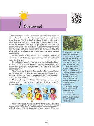
  • 1. After the long vacation, when Ravi started going to school again, he noticed that the only playground next to his school was dug up. People said that a huge building with many flats will be constructed there. Ravi was almost in tears, when he realised that the big playground with its soft grass, marigolds and butterflies is gone for ever. He shared his feelings with his classmates. In the assembly, the Principal too sadly observed, “See how our environment is changing.” In the class Ravi asked his teacher, “What is environment?” “Whatever you see in your surroundings,” said the teacher. Ravi thought aloud, “That means, the school building, tables, chairs in the classroom, even that open field, the road, the garbage, my friends – all are parts of our environment”! “Yes” said the teacher, “but wait….. Some objects are created by nature – for example, mountains, rivers, trees, animals. Others are made by people – for example roads, cars, clothes, books”. Now work in pairs. Make a list with your classmate sitting next to you, of the creations of nature and by human beings. Environment is our basic life support system. It provides the air we breath, the water we drink, the food we eat and the land where we live. How do human beings modify this natural environment? The car fumes pollute the air, water is collected in a pot, food is served in vessels and land is used to build factories. Human beings make cars, mills, factories and manufacture containers. This is how human beings modify natural environment. 1Environment Ravi, Paramjeet, Jessy, Mustafa, Asha were all excited about making the list. “Why is our environment changing?” asked Iqbal. “It’s all because of our needs. They are 2020-21
  • 2. 2 OUR ENVIRONMENT Natural Human made Human made Human Components of Environment Water (Hydrosphere) Air (Atmosphere) Land (Lithosphere) Living Things (Biosphere) Parks Buildings Bridges Roads Industries Monuments Individual Family Community Religion Educational Economic Political Situation Fig. 1.1: Components of Environment increasing day by day; we are therefore modifying and at times even destroying our natural surroundings”, the teacher replied. From the above conversation you understand that the place, people, things and nature that surround any living organism is called environment. It is a combination of natural and human made phenomena. While the natural environment refers to both biotic and abiotic conditions existing on the earth, Biotic The world of living organisms. e.g. plants and animals. Abiotic The world of non-living elements. e.g. land. 2020-21
  • 3. ENVIRONMENT 3 Let’s do Fig. 1.2: Domains of the Environment Hydrosphere Lithosphere Biosphere Atmosphere Let’s do human environment reveals the activities, creations and interactions among human beings. NATURAL ENVIRONMENT Land, water, air, plants and animals comprise the natural environment. You are familiar with the meaning of lithosphere, hydrosphere, atmosphere and biosphere from your previous class. Let us learn some more facts about these domains. Lithosphere is the solid crust or the hard top layer of the earth. It is made up of rocks and minerals and covered by a thin layer of soil. It is an irregular surface with various landforms such as mountains, plateaus, plains, valleys, etc. Landforms are found over the continents and also on the ocean floors. Lithosphere is the domain that provides us forests, grasslands for grazing, land for agriculture and human settlements. It is also a source of mineral wealth. Look at your surroundings. Make a list of uses that the land in your neighbourhood is being put to. Let’s do Where does the water you use in your home and school come from? Make a list of different uses of water in our daily life. Have you seen anyone wasting water? How? Observe the sky while coming to school. Make a note whether the day is cloudy, rainy, sunny, foggy etc. The domain of water is referred to as hydrosphere. It comprises various sources of water and different types of water bodies like rivers, lakes, seas, oceans, etc. It is essential for all living organisms. The atmosphere is the thin layer of air that surrounds the earth. The gravitational force of the earth holds the atmosphere around it. It protects us Word Origin Environment: French word Environer/ Environner meaning “neighbourhood”. 2020-21
  • 4. 4 OUR ENVIRONMENT Glossary Fig. 1.3: A Pond Ecosystem from the harmful rays and scorching heat of the sun. It consists of a number of gases, dust and water vapour. The changes in the atmosphere produce changes in the weather and climate. Plant and animal kingdom together make biosphere or the living world. It is a narrow zone of the earth where land, water and air interact with each other to support life. What is ecosystem? At an NCC camp that Ravi’s class was attending, Jessy exclaimed, “What a heavy downpour. It reminds me of my home in Kerala. You should come and see how it pours and pours and pours over the lush green fields and coconut plantations.” Heera from Jaisalmer exclaimed, “We get no rains. We see only ‘kikar’ and sand, as far as the eyes can see.” “But you also find camels”, said Ravi. Let’s do Sketch or bring photographs of your place like the students in the story. Ecosystem: It is a system formed by the interaction of all living organisms with each other and with the physical and chemical factors of the environment in which they live, all linked by transfer of energy and material. 2020-21
  • 5. ENVIRONMENT 5 Glossary Let’s do Barter System: It is a trade in which goods are exchanged without the use of money. Talk to some elderly person in your neighbourhood and collect information about– • The trees in his/ her neighbourhood when he/ she was your age. • The indoor games he/she played. • His/her favourite fruit at your age. • How did they make themselves comfortable during hot summers and cold winters? Display your answers on a wall/bulletin board. Heera says, “Not just camels. If you visit our desert, you will see snakes, lizards and many insects too.” Ravi wondered, “Why do the animals, the vegetation and the way people live vary from place to place? Are they all related to each other?” “Oh yes, very much so”, the teacher replied. All plants, animals and human beings depend on their immediate surroundings. Often they are also interdependent on each other. This relation between the living organisms, as well as the relation between the organisms and their surroundings form an ecosystem. There could be an ecosystem of large rain forest, grassland, desert, mountains, lake, river, ocean and even a small pond. Do you think the park in which Ravi and his friends played formed an ecosystem? HUMAN ENVIRONMENT Human beings interact with the environment and modify it according to their need. Early humans adapted themselves to the natural surroundings. They led a simple life and fulfilled their requirements from the nature around them. With time needs grew and became more varied. Humans learn new ways to use and change environment. They learn to grow crops, domesticate animals and lead a settled life. The wheel was invented, surplus food was produced, barter system emerged, trade started and commerce developed. Industrial revolution enabled large scale production. Transportation became faster. Information revolution made communication easier and speedy across the world. Have you ever thought why you love eating a juicy watermelon in summer and hot roasted peanuts in winter? A perfect balance is necessary between the natural and human environment. Humans must learn to live and use their environment in a harmonious way. Nurie, a girl from Mizoram from Ravi’s class often talks about the lush green surroundings of her place. Seeing Ravi upset at having lost his playground, Nurie invited him to visit her home state during the coming vacation. Ravi’s teacher asked the students to draw the landscape, houses and activities of the people and places they visit during the holidays. Do you know? On 5 June every year the World Environment Day is celebrated. 2020-21
  • 6. 6 OUR ENVIRONMENT 1. Answer the following questions. (i) What is an ecosystem? (ii) What do you mean by natural environment? (iii) Which are the major components of the environment? (iv) Give four examples of human made environment. (v) What is lithosphere? (vi) Which are the two major components of biotic environment? (vii) What is biosphere? 2. Tick the correct answer. (i) Which is not a natural ecosystem? (a) Desert (b) Aquarium (c) Forest (ii) Which is not a component of human environment? (a) Land (b) Religion (c) Community (iii) Which is a human made environment? (a) Mountain (b) Sea (c) Road (iv) Which is a threat to environment? (a) Growing plant (b) Growing population (c) Growing crops 3. Match the following. (i) Biosphere (a) blanket of air which surrounds the earth (ii) Atmosphere (b) domain of water (iii) Hydrosphere (c) gravitational force of the earth (iv) Environment (d) our surroundings (e) narrow zone where land water and air interact (f) relation between the organisms and their surroundings 4. Give reasons. (i) Man modifies his environment (ii) Plants and animals depend on each other 5. Activity. Imagine an ideal environment where you would love to live. Draw the picture of your ideal environment. Exercises 2020-21
  • 7. The earth, our homeland is a dynamic planet. It is constantly undergoing changes inside and outside. Have you ever wondered what lies in the interior of the earth? What is the earth made up of? INTERIOR OF THE EARTH Just like an onion, the earth is made up of several concentric layers with one inside another (Fig. 2.1). The uppermost layer over the earth’s surface is called the crust. It is the thinnest of all the layers. It is about 35 km. on the continental masses and only 5 km. on the ocean floors. The main mineral constituents of the continental mass are silica and alumina. It is thus called sial (si-silica and al-alumina). The oceanic crust mainly consists of silica and magnesium; it is therefore called sima (si-silica and ma-magnesium) (Fig. 2.2). Just beneath the crust is the mantle which extends up to a depth of 2900 km. below the crust. 2Inside Our Earth Do you know? • The deepest mine in the world, is in South Africa. It is about 4 km. deep. In search for oil engineers have dug a hole about 6 km. deep. • To reach to the centre of the earth (which is not possible!) you will have to dig a hole 6000 km. deep on the ocean floor. Crust Lithosphere Core-mantle boundary Mantle Outer core Inner core Fig. 2.1: Interior of the Earth Continental Crust Fig. 2.2: Continental Crust and Oceanic Crust Continent Ocean Oceanic Crust 2020-21
  • 8. 8 OUR ENVIRONMENT Glossary The innermost layer is the core with a radius of about 3500 km. It is mainly made up of nickel and iron and is called nife (ni – nickel and fe – ferrous i.e. iron). The central core has very high temperature and pressure. ROCKS AND MINERALS The earth’s crust is made up of various types of rocks. Any natural mass of mineral matter that makes up the earth’s crust is called a rock. Rocks can be of different colour, size and texture. There are three major types of rocks: igneous rocks, sedimentary rocks and metamorphic rocks. When the molten magma cools, it becomes solid. Rocks thus formed are called igneous rocks. They are also called primary rocks. There are two types of igneous rocks: intrusive rocks and extrusive rocks. Can you imagine lava coming out from the volcanoes? Lava is actually fiery red molten magma coming out from the interior of the earth on its surface. When this molten lava comes on the earth’s surface, it rapidly cools down and becomes solid. Rocks formed in such a way on the crust are called extrusive igneous rocks. They have a very fine grained structure. For example, basalt. The Deccan plateau is made up of basalt rocks. Sometimes the molten magma cools down deep inside the earth’s crust. Solid rocks so formed are called intrusive igneous rocks. Since they cool down slowly they form large grains. Granite is an example of such a rock. Grinding stones used to prepare paste/powder of spices and grains are made of granite. Rocks roll down, crack, and hit each other and are broken down into small fragments. These smaller particles are called sediments. These sediments are transported and deposited by wind, water, etc. These loose sediments are compressed and hardened to form layers of rocks. These types of rocks are called sedimentary rocks. For example, sandstone is made from grains of sand. These rocks may also contain fossils of plants, animals and other micro- organisms that once lived on them. Igneous and sedimentary rocks can change into metamorphic rocks under great heat and pressure (Fig. 2.3). For example, clay changes into slate and limestone into marble. Fig. 2.3: Sedimentary rock turned into a Metamorphic rock Fossils: The remains of the dead plants and animals trapped in the layers of rocks are called fossils. Word Origin Igneous: Latin word Ignis meaning fire. Sedimentary: Latin word sedimentum meaning settle down. Metamorphic: Greek word metamorphose meaning change of form. Do you know? • The crust forms only 1 per cent of the volume of the earth, 84 per cent consists of the mantle and 15 per cent makes the core. • The radius of the earth is 6371 km. 2020-21
  • 9. INSIDE OUR EARTH 9 Let’s do The Taj Mahal is made of white marble The Red Fort is made of red sandstone Collect pictures of some monuments and find out which are the rocks used to build them. Two pictures have been collected for you. Rocks are very useful to us. The hard rocks are used for making roads, houses and buildings. You use stones in many games. For example, seven stones (pitthoo), hop- scotch (stapu/kit kit), five stones (gitti). Find out some more such games by asking your grand parents, parents, neighbours, etc. You will be surprised to know that one type of rock changes to another type under certain conditions in a cyclic manner. This process of transformation of the rock from one to another is known as the rock cycle. You have already learnt when the molten magma cools; it solidifies to become igneous rock. These igneous rocks are broken down into small particles that are transported and deposited to form sedimentary rocks. When the igneous and sedimentary rocks are subjected to heat and pressure they change into metamorphic rocks. The metamorphic rocks which are still under great heat and pressure melt down to form molten magma. This molten magma again can cool down and solidify into igneous rocks (Fig. 2.4). Fig. 2.4: Rock Cycle 2020-21
  • 10. 10 OUR ENVIRONMENT Let’s do What are the minerals found in your state? Collect some samples to show in your class. 1. Answer the following questions. (i) What are the three layers of the earth? (ii) What is a rock? (iii) Name three types of rocks. (iv) How are extrusive and intrusive rocks formed? (v) What do you mean by a rock cycle? (vi) What are the uses of rocks? (vii) What are metamorphic rocks? 2. Tick the correct answer. (i) The rock which is made up of molten magma is (a) Igneous (b) Sedimentary (c) Metamorphic (ii) The innermost layer of the earth is (a) Crust (b) Core (c) Mantle (iii) Gold, petroleum and coal are examples of (a) Rocks (b) Minerals (c) Fossils (iv) Rocks which contain fossils are (a) Sedimentary rocks (b) Metamorphic rocks (c) Igneous rocks (v) The thinnest layer of the earth is (a) Crust (b) Mantle (c) Core 3. Match the following. (i) Core (a) Earth’s surface (ii) Minerals (b) Used for roads and buildings (iii) Rocks (c) Made of silicon and alumina (iv) Clay (d) Has definite chemical composition (v) Sial (e) Innermost layer (f) Changes into slate (g) Process of transformation of the rock Rocks are made up of different minerals. Minerals are naturally occurring substances which have certain physical properties and definite chemical composition. Minerals are very important to humankind. Some are used as fuels. For example, coal, natural gas and petroleum. They are also used in industries – iron, aluminium, gold, uranium, etc, in medicine, in fertilisers, etc. Exercises 2020-21
  • 11. INSIDE OUR EARTH 11 4. Give reasons. (i) We cannot go to the centre of the earth. (ii) Sedimentary rocks are formed from sediments. (iii) Limestone is changed into marble. 5. For fun. (i) What are the minerals most commonly used in the following objects? (ii) Identify some more objects made up of different minerals. Karhai Ornaments Pan/Tava Bell Hammer Lamp 2020-21
  • 12. Activity Take a small coloured paper pellet and put it in a beaker half filled with water. Place the beaker on a tripod stand and heat it. As the water warms up, you will observe that the paper pellet is moving upward along with the warm layers of water and then sinks back along with the cooler layers of water. The molten magma inside the earth moves in a similar manner. The lithosphere is broken into a number of plates known as the Lithospheric plates. You will be surprised to know that these plates move around very slowly – just a few millimetres each year. This is because of the movement of the molten magma inside the earth. The molten magma inside the earth moves in a circular manner as shown in the activity. The movement of these plates causes changes on the surface of the earth. The earth movements are divided on the basis of the forces which cause them. The forces which act in the interior of the earth are called as Endogenic forces and the forces that work on the surface of the earth are called as Exogenic forces (Fig. 3.1). 3 Our Changing Earth Glossary Lithospheric plates: The earth’s crust consists of several large and some small, rigid, irregularly- shaped plates (slabs) which carry continents and the ocean floor. Fig. 3.1: Evolution of Landforms Earth movements Endogenic forces Exogenic forces Sudden forces Diastrophic forces Erosional and Depositional Building mountains Earthquake Volcano Landslides River Wind Sea-waves Glaciers Endogenic forces sometimes produce sudden movements and at the other times produce slow movements. Sudden movements like earthquakes and volcanoes cause mass destruction over the surface of the earth. 2020-21
  • 13. Crater Lava tube Vent Lava Gases and ash Crust Mantle Magma Chamber Word Origin Fig. 3.2: A Volcano Epicentre Seismic waves radiate out in all directions Plate boundary Focus – this is where the earthquake occurs. It is the origin of the seismic energy A volcano is a vent (opening) in the earth’s crust through which molten material erupts suddenly (Fig. 3.2). Fig. 3.3: Origin of an Earthquake Activity Take a container, fill it with water and close it with a lid. Put the water to boil. Now put some peas, spoon and beads on top on the lid. What do you notice? As the water boils the lid begins to shake. The things which you have put on the lid also vibrate. The beads roll down and the spoon vibrates to make a sound. In the same manner, the earth vibrates when an earthquake occurs. Do you know? There are three types of earthquake waves: 1. P waves or longitudinal waves 2. S waves or transverse waves 3. L waves or surface waves Try to find out the properties of these waves from an encyclopedia. Similarly, when the Lithospheric plates move, the surface of the earth vibrates. The vibrations can travel all round the earth. These vibrations are called earthquakes (Fig. 3.3). The place in the crust where the movement starts is called the focus. The place on the surface above the focus is called the epicentre. Vibrations travel outwards from the epicentre as waves. Greatest damage is usually closest to the epicentre and the strength of the earthquake decreases away from the centre. Endo (inside) Exo (outside) Endogenic Exogenic + genic (origin) 13 OUR CHANGING EARTH . 2020-21
  • 14. 14 OUR ENVIRONMENT Activity Do you know? An earthquake is measured with a machine called a seismograph. The magnitude of the earthquake is measured on the Richter scale. An earthquake of 2.0 or less can be felt only a little. An earthquake over 5.0 can cause damage from things falling. A 6.0 or higher magnitude is considered very strong and 7.0 is classified as a major earthquake. A Seismograph EARTHQUAKE PREPAREDNESS Where to take shelter during an earthquake — Safe Spot – Under a kitchen counter, table or desk, against an inside corner or wall. Stay Away from – Fire places, areas around chimneys, windows that shatter including mirrors and picture frames. Be Prepared – Spread awareness amongst your friends and family members and face any disaster confidently. Fig. 3.3a: Destruction caused by an Earthquake in Gujarat 1. Read the ‘Earthquake – A case study’ given in the form of headlines that appeared in the newspapers after the quake. Arrange the events in the right sequence of their happening. 2. Imagine if a quake suddenly shook in the middle of the school day, where would you go for safety? Although earthquakes cannot be predicted, the impact can certainly be minimised if we are prepared before-hand. Some common earthquake prediction methods adopted locally by people include studying animal behaviour; fish in the ponds get agitated, snakes come to the surface. EARTHQUAKE HITS BHUJ A massive earthquake measuring 6.9 on Richter scale hit Bhuj Town on 26th January 2001. Fire in the city Hundreds of fires started as charcoal, cookers overturned. Emergency declared in quake zone The President declares a state of emergency. Atleast 971 students and 31 teachers are feared to have lost their lives following the collapse of school buildings. School worst affected CM’S APPEAL TO THE CENTRE Gujarat appeals for financial help. The Chief Minister of Gujarat has launched an appeal for the Centre to deal with the disaster. Destruction of Bhuj Phone lines, water pipelines and power stations transmission lines were knocked out. 1 2 3 4 5 6 7 BHUJ RELIEF EFFORT BLIGHTED.. Three days after the quake, concern rose about food, blankets and medical supplies not reaching everyone. Earthquake – A Case Study 2020-21
  • 15. 15 OUR CHANGING EARTH Fig. 3.5: Features made by a river in a flood plain Do you know? MAJOR LAND FORMS The landscape is being continuously worn away by two processes – weathering and erosion. Weathering is the breaking up of the rocks on the earth’s surface. Erosion is the wearing away of the landscape by different agents like water, wind and ice. The eroded material is carried away or transported by water, wind, etc. and eventually deposited. This process of erosion and deposition create different landforms on the surface of the earth. Work of a River The running water in the river erodes the landscape. When the river tumbles at steep angle over very hard rocks or down a steep valley side it forms a waterfall (Fig. 3.4). • There are thousands of small waterfalls in the world. The highest waterfall is Angel Falls of Venezuela in South America. The other waterfalls are Niagara falls located on the border between Canada and USA in North America and Victoria Falls on the borders of Zambia and Zimbabwe in Africa. The Niagra falls Hard rock Softer rock undercut by the power of the water Fig. 3.4: Waterfall As the river enters the plain it twists and turns forming large bends known as meanders. Due to continuous erosion and deposition along the sides of the meander, the ends of the meander loop come closer and closer. In due course of time the meander loop cuts off from the river and forms a cut-off lake, also called an ox-bow lake. At times the river overflows its banks. This leads to the flooding of the neighbouring areas. As it floods, it deposits layers of fine soil and other material called sediments along its banks. This leads to the formation of a flat fertile floodplain. The raised banks are called levees. As the river approaches the sea, the speed of the flowing water decreases and the 2020-21
  • 16. 16 OUR ENVIRONMENT river begins to break up into a number of streams called distributaries. The river becomes so slow that it begins to deposit its load. Each distributary forms its own mouth. The collection of sediments from all the mouths forms a delta. Work of Sea Waves The erosion and deposition of the sea waves gives rise to coastal landforms. Seawaves continuously strike at the rocks. Cracks develop. Over time they become larger and wider. Thus, hollow like caves are formed on the rocks. They are called sea caves. As these cavities become bigger and bigger only the roof of the caves remain, thus forming sea arches. Further, erosion breaks the roof and only walls are left. These wall like features are called stacks. The steep rocky coast rising almost vertically above sea water is called sea cliff. The sea waves deposit sediments along the shores forming beaches. Work of Ice Glaciers are “rivers of ice” which too erode the landscape by bulldozing soil and stones to expose the solid rock below. Glaciers carve out deep hollows there. As the ice melts they get filled up with water and become beautiful lakes in the mountains. The material carried by the glacier such as rocks big and small, sand and silt gets deposited. These deposits form glacial moraines. Let’s do Find out the names of a few rivers of the world that form a delta. Fig. 3.8: A Glacier Main river Distributary Fig. 3.6: A Delta Sea Cave Sea Arch Stack Fig. 3.7: Features made by sea waves 2020-21
  • 17. 17 OUR CHANGING EARTH Work of wind Have you ever visited a desert? Try to collect some pictures of sand dunes. An active agent of erosion and deposition in the deserts is wind. In deserts you can see rocks in the shape of a mushroom, commonly called mushroom rocks. Winds erode the lower section of the rock more than the upper part. Therefore, such rocks have narrower base and wider top. When the wind blows, it lifts and transports sand from one place to another. When it stops blowing the sand falls and gets deposited in low hill – like structures. These are called sand dunes (Fig. 3.9). When the grains of sand are very fine and light, the wind can carry it over very long distances. When such sand is deposited in large areas, it is called loess. Large deposits of loess is found in China. Fig. 3.9: Sand Dunes Exercises 1. Answer the following questions. (i) Why do the plates move? (ii) What are exogenic and endogenic forces? (iii) What is erosion? (iv) How are flood plains formed? (v) What are sand dunes? (vi) How are beaches formed? (vii) What are ox bow lakes? 2. Tick the correct answer. (i) Which is not an erosional feature of sea waves? (a) Cliff (b) Beach (c) Sea cave (ii) The depositional feature of a glacier is: (a) Flood plain (b) Beach (c) Moraine (iii) Which is caused by the sudden movements of the earth? (a) Volcano (b) Folding (c) Flood plain (iv) Mushroom rocks are found in: (a) Deserts (b) River valleys (c) Glaciers (v) Ox bow lakes are found in: (a) Glaciers (b) River valleys (c) Deserts 2020-21
  • 18. 18 OUR ENVIRONMENT 3. Match the following. (i) Glacier (a) Sea shore (ii) Meanders (b) Mushroom rock (iii) Beach (c) River of ice (iv) Sand dunes (d) Rivers (v) Waterfall (e) Vibrations of earth (vi) Earthquake (f) Sea cliff (g) Hard bed rock (h) Deserts 4.Give reasons. (i) Some rocks have a shape of a mushroom. (ii) Flood plains are very fertile. (iii) Sea caves are turned into stacks. (iv) Buildings collapse due to earthquakes. 5. Activity. Observe the photographs given below. These are various features made by a river. Identify them and also tell whether they are erosional or depositional or landforms formed by both. Photograph Name of the Feature Type (Erosional or Depositional or Both) 2020-21
  • 19. 19 OUR CHANGING EARTH Down 1. Rise and fall of water caused by friction of wind on water surface 3. Flow of water in a channel 5. Steep perpendicular face of a rock along a sea coast 6. Debris of boulder and coarse material carried by glacier 8. Crescent shaped lake formed by a meandering river 10. Finesanddepositedbytheactionofthewind 13. Isolated mass of rising steep rock near a coastline 14. Alluvial tracts of land formed by the river deposits at the mouth of a river Across 2. Loop like the bend of a river 4. Solid form of water 7. Moving mass of ice 9. Sudden descent of water in the bed of a river 11. Natural cavity on weak rocks formed by action of waves 12. Embankment on a river that keeps it in its channel 13. Large body of sea water 14. Dry area where sand dunes are found 15. Small hill of sand caused by the action of the wind 16. Flat plain formed by river deposits during time of flood 6. For fun. Solve the crossword puzzle with the help of given clues. 2020-21
  • 20. Our earth is surrounded by a huge blanket of air called atmosphere. All living beings on this earth depend on the atmosphere for their survival. It provides us the air we breathe and protects us from the harmful effects of the sun’s rays. Without this blanket of protection, we would be baked alive by the heat of the sun during day and get frozen during night. So it is this mass of air that has made the temperature on the earth liveable. COMPOSITION OF THE ATMOSPHERE Do you know that the air we take in while breathing is actually a mixture of many gases? Nitrogen and oxygen are two gases which make up the bulk of the atmosphere. Carbon dioxide, helium, ozone, argon and hydrogen are found in lesser quantities. Apart from these gases, tiny dust particles are also present in the air. The pie chart gives you the percentage of different constituents of air (Fig. 4.1). Nitrogen is the most plentiful gas in the air. When we inhale, we take some amount of nitrogen into our lungs and exhale it. But plants need nitrogen for their survival. They can not take 4Air Fig. 4.1: Constituents of Air Do you know? Carbon dioxide released in the atmosphere creates a green house effect by trapping the heat radiated from the earth. It is therefore called a greenhouse gas and without it the earth would have been too cold to live in. However, when its level in the atmosphere increases due to factory smoke or car fumes, the heat retained increases the temperature of the earth. This is called global warming. This rise in temperature causes the snow in coldest parts of the world to melt. As a result the sea level rises, causing floods in the coastal areas. There may be drastic changes in the climate of a place leading to extinction of some plants and animals in the long run. 2020-21
  • 21. nitrogen directly from the air. Bacteria, that live in the soil and roots of some plants, take nitrogen from the air and change its form so that plants can use it. Oxygen is the second most plentiful gas in the air. Humans and animals take oxygen from the air as they breathe. Green plants produce oxygen during photosynthesis. In this way oxygen content in the air remains constant. If we cut trees then this balance gets disturbed. Carbon dioxide is another important gas. Green plants use carbon dioxide to make their food and release oxygen. Humans or animals release carbon dioxide. The amount of carbon dioxide released by humans or animals seems to be equal to the amount used by the plants which make a perfect balance. However, the balance is upset by burning of fuels, such as coal and oil. They add billions of tons of carbon dioxide into the atmosphere each year. As a result, the increased volume of carbon dioxide is affecting the earth’s weather and climate. A c t i v i t y Read and Ponder: Is global warming a serious issue in today’s world? Do you know? When air is heated, it expands, becomes lighter and goes up. Cold air is denser and heavy. That is why it tends to sink down. When hot air rises, cold air from surrounding area rushes there to fill in the gap. That is how air circulation takes place. AIR 21 2020-21
  • 22. 22 OUR ENVIRONMENT STRUCTURE OF THE ATMOSPHERE Our atmosphere is divided into five layers starting from the earth’s surface. These are Troposphere, Stratosphere, Mesosphere, Thermosphere and Exosphere (Fig. 4.2). Troposphere: This layer is the most important layer of the atmosphere. Its average height is 13 km. The air we breathe exists here. Almost all the weather phenomena like rainfall, fog and hailstorm occur in this layer. Stratosphere: Above the troposphere lies the stratosphere. It extends up to a height of 50 km. This layer is almost free from clouds and associated weather phenomenon, making conditions most ideal for flying aeroplanes. One important feature of stratosphere is that it contains a layer of ozone gas. We have just learnt how it protects us from the harmful effect of the sun rays. Mesosphere: This is the third layer of the atmosphere. It lies above the stratosphere. It extends up to the height of 80 km. Meteorites burn up in this layer on entering from the space. Thermosphere: In thermosphere temperature rises very rapidly with increasing height. Ionosphere is a part of this layer. It extends between Fig. 4.2: Layers of the Atmosphere 2020-21
  • 23. AIR 23 Do you know? You will be surprised to know that the earth receives only 1 in 2,000,000,000 parts of the sun’s energy. 80-400 km. This layer helps in radio transmission. In fact, radio waves transmitted from the earth are reflected back to the earth by this layer. Exosphere: The upper most layer of the atmosphere is known as exosphere. This layer has very thin air. Light gases like helium and hydrogen float into the space from here. WEATHER AND CLIMATE “Is it going to rain today?” “Will it be bright and sunny today?” How many times have we heard this from anxious cricket fans speculating the fate of a One Day match? If we imagine our body to be a radio and the mind its speaker, weather is something that fiddles with its control knobs. Weather is this hour-to-hour, day to day condition of the atmosphere. A hot or humid weather may make one irritable. A pleasant, breezy weather may make one cheerful and even plan for an outing. Weather can change dramatically from day to day. However, the average weather condition of a place for a longer period of time represents the climate of a place. Now do you understand why we have daily weather forecasts. Temperature The temperature you feel everyday is the temperataure of the atmosphere. The degree of hotness and coldness of the air is known as temperature. The temperature of the atmosphere changes not only between day and night but also from season to season. Summers are hotter than winters. An important factor that influences the distribution of temperature is insolation. Insolation is the incoming solar energy intercepted by the earth. The amount of insolation decreases from the equator towards the poles. Therefore, the Let’s do For ten days note down weather report from a local newspaper and observe the changes occurring in the weather. Wind Vane: Shows the direction of the wind Rain Gauge: Measures the amount of rainfall Thermometer: Measures the temperature Barometre: Measures atmospheric pressure Fig. 4.3: Weather Instruments 2020-21
  • 24. 24 OUR ENVIRONMENT temperature decreases in the same manner. Now do you understand why poles are covered with snow? If the earth’s temperature rises too high, it would become too warm for some crops to grow. Temperature in cities is much higher than that of villages. The concrete and metals in buildings and the asaphalt of roads get heated up during the day. This heat is released during the night. Also, the crowded high rise buildings of the cities trap the warm air and thus raise the temperature of the cities. Air Pressure You will be surprised to know that air above us presses us with a great force on our bodies. However, we don’t even feel it. This is because the air presses us from all directions and our body exerts a counter pressure. Air pressure is defined as the pressure exerted by the weight of air on the earth’s surface. As we go up the layers of atmosphere, the pressure falls rapidly. The air pressure is highest at sea level and decreases with height. Horizontally the distribution of air pressure is influenced by temperature of air at a given place. In areas where temperature is high the air gets heated and rises. This creates a low-pressure area. Low pressure is associated with cloudy skies and wet weather. In areas having lower temperature, the air is cold. It is therefore heavy. Heavy air sinks and creates a high pressure area. High pressure is associated with clear and sunny skies. The air always moves from high pressure areas to low pressure areas. Wind The movement of air from high pressure area to low pressure areas is called wind. You can see wind at work as it blows dry leaves down the pavement or uproots trees during a storm. Sometimes when the wind blows gently you can even see it blowing away smoke or fine dust. At times wind can be so strong that it is difficult to walk against it. You must have experienced it is not easy to hold an umbrella on a windy day. Think of some other examples when strong winds have created Do you know? On the moon there is no air and hence no air pressure. Astronauts have to wear special protective space suits filled with air when they go to the moon. If they did not wear these space suits, the counter pressure exerted by the body of the astronauts would make the blood vessels burst. The astronauts would bleed. Do you know? The standard unit of measuring temperature is degree Celsius. It was invented by Anders Celsius. On the Celsius scale the water freezes at 0°C and boils at 100°C. Do you know? A wind is named after the direction from which it blows, e.g. the wind blowing from the west is called westerly. 2020-21
  • 25. AIR 25 Sub-Polar Low Pressure Sub - Tropical High Pressure (Horse Latitudes) Sub - Tropical High Pressure (Horse Latitudes) Sub-Polar Low Pressure High Pressure High Pressure Equatorial Low Pressure (Doldrums) P o l a r E a s t e r l i e s P r e v a i l i n g W e s t e r l i e s N o r t h e a s t T r a d e W i n d s S o u t h e a s t T r a d e W i n d s P o l a r E a s t e r l i e s P r e v a i l i n g W e s t e r l i e s 60°S 23.5°N 30°N 35°N 0° 60°N 23.5°S 30°S 35°S 90°N 90°S T r o p i c o f C a n c e r Tropic of Capricorn CYCLONE – NATURE’S FURY Odisha, located on the eastern seacoast of India is prone to cyclones that originate in the Bay of Bengal. On 17-18 October 1999, cyclone hit five districts of the state. Another supercyclone occurred on the 29 October 1999, that devastated large portions of the state. The damages caused were mainly due to three factors: wind velocity, rain and tidal surge. The winds of upto 260 km. per hour lasted for over 36 hours. These high velocity winds uprooted trees and damaged the kutcha houses. Roof tops of several industrial sheds and other houses were also blown away. Power supply and telecom lines snapped completely. Heavy rain occurred under the influence of the cyclone for three days continuously. These rains led to flooding in the major rivers of Odisha. The cyclonic winds caused tidal waves that swept 20 km. inland and brought massive destruction to the coastal areas. The 7 to 10 m high tidal wave intruded suddenly and caused massive damage to the standing paddy crops. Destruction caused by a cyclone Fig. 4.4: Major Pressure Belts and Wind System problems for you. Winds can be broadly divided into three types. 1. Permanent winds – The trade winds, westerlies and easterlies are the permanent winds. These blow constantly throughout the year in a particular direction. 2. Seasonal winds – These winds change their direction in different seasons. For example monsoons in India. 3. Local winds – These blow only during a particular period of the day or year in a small area. For example, land and sea breeze. Do you recall the hot and dry local wind of northern planes of India? It is called loo. 2020-21
  • 26. 26 OUR ENVIRONMENT The cyclone originated as a “depression” in the Gulf of Thailand, near east of Port Blair, on 25 October 1999 and gradually moved in a northwestward direction. It intensified into a supercyclone and hit the area between Erasama and Balikuda in Odisha on 29 October at 10.30 a.m. The supercyclone swept the entire coast of Odisha including the cities of Bhubaneshwar and Cuttack and 28 coastal towns. About 13 million people were affected. A large number of livestock were killed. Standing crops of paddy, vegetables and fruits were heavily damaged. Due to salinisation caused by tidal surge, large tracts of agricultural land have turned infertile. Large tracts of sal, teak and bamboo plantations have disappeared. The mangrove forests between Paradeep and Konark vanished. Moisture When water evaporates from land and different water bodies, it becomes water vapour. Moisture in the air at any time, is known as humidity. When the air is full of water vapour we call it a humid day. As the air gets warmer, its capacity to hold the water vapour increases and so it becomes more and more humid. On a humid day, clothes take longer to dry and sweat from our body does not evaporate easily, making us feel very uncomfortable. When the water vapour rises, it starts cooling. The water vapour condenses causing formation of droplets of water. Clouds are just masses of such water droplets. When these droplets of water become too heavy to float in air, then they come down as precipitation. Jet planes flying in the sky leave a white trail behind them. The moisture from their engines condenses. We see trails of this condensed moisture for some time when there is no air movement to disturb it. Precipitation that comes down to the earth in liquid form is called rain. Most of the ground water comes from rainwater. Plants help preserve water. When trees on hill sides are cut, rainwater flows down the bare mountains and can cause flooding of low lying areas. On the basis of mechanism, there are three types of rainfall: the convectional rainfall, the orographic rainfall and the cyclonic rainfall (Fig. 4.5). Cyclonic Rainfall Convectional Rainfall Relief (Orographic) Rainfall Fig. 4.5: Types of Rainfall Warm air Cold air Moist air Warm air 2020-21
  • 27. AIR 27 Exercises 1. Answer the following questions. (i) What is atmosphere? (ii) Which two gases make the bulk of the atmosphere? (iii) Which gas creates green house effect in the atmosphere? (iv) What is weather? (v) Name three types of rainfall? (vi) What is air pressure? 2. Tick the correct answer. (i) Which of the following gases protects us from harmful sun vays? (a) Carbon dioxide (b) Nitrogen (c) Ozone (ii) The most important layer of the atmosphere is (a) Troposphere (b) Thermosphere (c) Mesosphere (iii) Which of the following layers of the atmosphere is free from clouds? (a) Troposphere (b) Stratosphere (c) Mesosphere (iv) As we go up the layers of the atmosphere, the pressure (a) Increases (b) Decreases (c) Remains the same (v) When precipitation comes down to the earth in the liquid form, it is called (a) Cloud (b) Rain (c) Snow 3. Match the following. (i) Trade Winds (a) Incoming solar energy (ii) Loo (b) Seasonal wind (iii) Monsoon (c) Horizontal movement of Air (iv) Wind (d) Layer of ozone gas (e) Permanent wind (f) Local wind 4. Give reasons. (i) Wet clothes take longer time to dry on a humid day? (ii) Amount of insolation decreases from equator towards poles? Do you know? Other forms of precipitation are snow, sleet, hail. Rainfall is very important for the survival of plants and animals. It brings fresh water to the earth’s surface. If rainfall is less – water scacity and drought occur. On the other hand if it is more, floods take place. 2020-21
  • 28. 28 OUR ENVIRONMENT Down 1. Amount of water vapour in air 2. Condensation of water vapours around dust particles in atmosphere 3. Example of local wind blowing in summer in northern india 4. Short term changes in atmosphere 5. Precipitation in liquid form 7. Blanket of air around the earth 9. Instrument to measure pressure 10. Incoming solar radiation 13. Reduces visibility in winters 17. It is ....... time when sun is overhead Across 6. An Indian tree having extraordinary quality of providing oxygen round the clock 8. Gas present in atmosphere occupying only 0.03% by volume 11. Outermost layer of atmosphere 12. Mixture of many gases 14. Life giving gas 15. Air in motion 16. An indian tree valued highly for medicinal properties 18. Gas protecting us from harmful sunrays 19. Low pressure area 5. For fun. (i) Solve this Crossword puzzle with the help of given clues: 2020-21
  • 29. AIR 29 1. 2. 3. 4. 5. 6. 7. Sunny day Day Weather (ii) Make a weather calendar for one week. Use pictures or symbols to show different types of weather. You can use more than one symbol in a day, if the weather changes. For example, the sun comes out when rain stops. An example is given below: 2020-21
  • 30. Glossary Fig. 5.1: Water Cycle Condensation Precipitation Run off Evaporation 5Water When you think of water, what images come to your mind? You think of rivers, the waterfalls, the pitter patter of raindrops, water in your taps... Children love to float paper boats in rain puddles. By noon the puddles vanish. Where does the water go? The sun’s heat causes evaporation of water into vapour. When the water vapour cools down, it condenses and forms clouds. From there it may fall on the land or sea in the form of rain, snow or sleet. The process by which water continually changes its form and circulates between oceans, atmosphere and land is known as the water cycle (Fig 5.1). Our earth is like a terrarium. The same water that existed centuries ago still exists today. The water used to irrigate a field in Haryana may have flowed down the Amazon River a hundred years ago. The major sources of fresh water are the rivers, ponds, springs and glaciers. The ocean bodies and the seas contain salty water. The water of the oceans is salty or saline as it contains large Terrarium: It is an artificial enclosure for keeping small house plants. Activity Fill one-fourth of a big jar with soil and press it well. Put a thin layer of humus on top of it. Plant the largest plants first and then arrange the smaller ones around them. Spray the arrangement with water and close the jar. The water that evaporates from the leaves and soil condenses and falls back in the form of drops of water. A Terrarium Make your own Terrarium 2020-21
  • 31. Fig. 5.2: World – Major Seas, Lakes and Rivers WATER 31 amount of dissolved salts. Most of the salt is sodium chloride or the common table salt that you eat. 2020-21
  • 32. 32 OUR ENVIRONMENT Do you know? Activity Distribution of fresh water 1 Drop = rivers 9 Spoons = icecaps 2 Spoons = ground water ½ Spoons = fresh water lakes Take 2 litres of water. Let it represent the total water on the surface of the earth. Measure out 12 spoons of water from this vessel into another bowl. The water that is left behind in the vessel represents the salty water found in oceans and seas. This water is obviously not fit for consuming. It is saline (contains salts). The 12 spoons of water that was taken in a bowl is the total amount of fresh water on earth. The figure shows us the distribution of this fresh water. See for yourself how much water can actually be used by you. Do you know? Dead sea in Israel has salinity of 340 grams per litre of water. Swimmers can float in it because the increased salt content makes it dense. Oceans : 97.3 Ice-caps : 02.0 Ground water : 0.68 Fresh water lakes : 0.009 Inland seas and salt lakes : 0.009 Atmosphere : 0.0019 Rivers : 0.0001 100.00 Saline Water Fresh Water Salinity is the amount of salt in grams present in 1000 grams of water. The average salinity of the oceans is 35 parts per thousand. DISTRIBUTION OF WATER BODIES We all know that three-fourth of the earth surface is covered by water. If there is more water than land on this earth, why do so many countries face water scarcity? Is all the water on earth available to us? The following table gives the distribution of water in percentage. Water distribution can be demonstrated by a simple activity (see activity box). Water is absolutely essential for survival. Water alone can quench our thirst when we are thirsty. Now don’t you think we are wasting a precious resource when we use water carelessly? 2020-21
  • 33. WATER 33 A c t i v i t y OCEAN CIRCULATION There is something magical about walking bare feet on the seashore. The wet sand on the beach, the cool breeze, the seabirds, the smell of the salt in the air and music of the waves; everything is so fascinating. Unlike the calm waters of ponds and lakes, ocean water keeps moving continuously. It is never still. The movements that occur in oceans can be broadly categorised as: waves, tides and currents. Do you know? March 22 is celebrated as World Water Day when the need to conserve water is reinforced in different ways. • Why is water important for us? • Suggest some ways in which water can be conserved (a) in your home (b) in your school Fig. 5.3: Pacific Ocean 2020-21
  • 34. 34 OUR ENVIRONMENT Waves When you are playing throw ball on the beach and the ball falls into the water, what happens? It is fun to watch how the ball gets washed back to the shore by the waves. When the water on the surface of the ocean rises and falls alternately, they are called waves. Do you know? Tsunami is a Japanese word that means “Harbour waves” as the harbours get destroyed whenever there is tsunami. TSUNAMI – THE EARTH’S PANDEMONIUM Tsunami or the harbour wave struck havoc in the Indian Ocean on the 26 December 2004. The wave was the result of the earthquake that had its epicenter close to the western boundary of Sumatra. The magnitude of the earthquake was 9.0 on the Richter scale. As the Indian plate went under the Burma plate, there was a sudden movement of the sea floor, causing the earthquake. The ocean floor was displaced by about 10 – 20m and tilted in a downwardly direction. A huge mass of ocean water flowed to fill in the gap that was being created by the displacement. This marked the withdrawal of the water mass from the coastlines of the landmasses in the south and southeast Asia. After thrusting of the Indian plate below the Burma plate, the water mass rushed back towards the coastline. Tsunami travelled at a speed of about 800km. per hour, comparable to speed of commercial aircraft and completely washed away Do you know? Waves are formed when winds scrape across the ocean surface. The stronger the wind blows, the bigger the wave becomes. Fig. 5.4: Waves During a storm, the winds blowing at very high speed form huge waves. These may cause tremendous destruction. An earthquake, a volcanic eruption or underwater landslides can shift large amounts of ocean water. As a result a huge tidal wave called tsunami, that may be as high as 15m., is formed. The largest tsunami ever measured was 150m. high. These waves travel at a speed of more than 700 km. per hour. The tsunami of 2004 caused wide spread damage in the coastal areas of India. The Indira point in the Andaman and Nicobar islands got submerged after the tsunami. 2020-21
  • 35. WATER 35 some of the islands in the Indian ocean. The Indira point in the Andaman and Nicobar islands that marked the southernmost point of India got completely submerged. As the wave moved from earthquake epicenter from Sumatra towards the Andaman islands and Sri Lanka the wave length decreased with decreasing depth of water. The travel speed also declined from 700-900km. per hour to less than 70km. per hour. Tsunami waves travelled upto a depth of 3 km. from the coast killing more than 10,000 people and affected more than lakh of houses. In India, the worst affected were the coastal areas of Andhra Pradesh, Tamil Nadu, Kerala, Puducherry and the Andaman and Nicobar Islands. While the earthquake cannot be predicted in advance, it is possible to give a three-hour notice of a potential tsunami. Such early warning systems are in place across the Pacific ocean, but not in the Indian Ocean. Tsunamis are rare in the Indian Ocean as the seismic activity is less as compared to the Pacific. Destruction caused by tsunami on Tamil Nadu Coast The tsunami that ravaged the South and South east Asian coasts in December 2004, is the most devastating tsunami in the last several hundred years. The large damage caused to life and property was primarily a result of lack of monitoring, the early warning systems and knowledge among the coast dwellers of Indian ocean. The first indication that tsunami is approaching is the rapid withdrawal of water from the coastal region, followed by destructive wave. When this happened on the coast, instead of people going to high ground, they started assembling at the coast to view the miracle. As a consequence there was a large casualty of curious onlookers when the gigantic wave (tsunami) struck. Tides The rhythmic rise and fall of ocean water twice in a day is called a tide. It is high tide when water covers much of the shore by rising to its highest level. It is low tide when water falls to its lowest level and recedes from the shore. 2020-21
  • 36. 36 OUR ENVIRONMENT The strong gravitational pull exerted by the sun and the moon on the earth’s surface causes the tides. The water of the earth closer to the moon gets pulled under the influence of the moon’s gravitational force and causes high tide. During the full moon and new moon days, the sun, the moon and the earth are in the same line and the tides are highest. These tides are called spring tides. But when the moon is in its first and last quarter, the ocean waters get drawn in diagonally opposite directions by the gravitational pull of sun and moon resulting in low tides. These tides are called neap tides (Fig. 5.5). High tides help in navigation. They raise the water level close to the shores. This helps the ships to arrive at the harbour more easily. The high tides also help in fishing. Many more fish come closer to the shore during the high tide. This enables fishermen to get a plentiful catch. The rise and fall of water due to tides is being used to generate electricity in some places. OCEAN CURRENTS Ocean currents are streams of water flowing constantly on the ocean surface in definite directions. The ocean currents may be warm or cold (Fig. 5.6). Generally, the warm ocean currents originate near the equator and move towards the poles. The cold currents carry water from polar or higher latitudes to tropical or lower latitudes. The Labrador Ocean current is cold current while the Gulf Stream is a warm current. The ocean current influence the temperature conditions of the area. Warm currents bring about warm temperature over land surface. The areas where the warm and cold currents meet provide the best fishing grounds of the Activity Fill three-fourths of a bucket with tap water. Heat the water by putting an immersion rod on one side of the bucket. On the other side introduce an ice tray just removed from the freezer. Add a drop of red ink to observe the path of current by the process of convection. Fig. 5.5: Spring Tides and Neap Tide Spring Tide Sun Earth Moon Sun Earth Moon Sun Earth Moon Neap Tide 2020-21
  • 37. WATER 37 Exercises Fig. 5.6: Ocean Currents world. Seas around Japan and the eastern coast of North America are such examples. The areas where a warm and cold current meet also experience foggy weather making it difficult for navigation. 1. Answer the following questions. (i) What is precipitation? (ii) What is water cycle? (iii) What are the factors affecting the height of the waves? (iv) Which factors affect the movement of ocean water? (v) What are tides and how are they caused? (vi) What are ocean currents? 2. Give reasons. (i) Ocean water is salty. (ii) The quality of water is deterioting. 2020-21
  • 38. 38 OUR ENVIRONMENT 3. Tick the correct answer. (i) The process by which water continually changes its form and circulates between oceans, atmosphere and land (a) Water cycle (b) Tides (c) Ocean currents (ii) Generally the warm ocean currents originate near (a) Poles (b) Equator (c) None of these (iii) The rythmic rise and fall of ocean water twice in a day is called (a) Tide (b) Ocean current (c) Wave 4. Match the following. (i) Caspian Sea (a) Largest lake (ii) Tide (b) Periodic rise and fall of water (iii) Tsunami (c) Strong seismic waves (iv) Ocean currents (d) Streams of water moving along definite paths (e) Water cycle 5. For fun. Be a Detective (i) The name of one river is hidden in each of the sentences below. Spot it. Example: Mandira, Vijayalakshmi and Surinder are my best friends Answer: Ravi (a) The snake charmer’s bustee, stables where horses are housed, and the piles of wood, all caught fire accidentally. (Hint: Another name for River Brahmputra) (b) The conference manager put pad, material for reading and a pencil for each participant. (Hint: A distributary on the Ganga-Brahmputra delta) (c) Either jealousy or anger cause a person’s fall (Hint: Name of a juicy fruit!) (d) Bhavani germinated the seeds in a pot (Hint: Look for her in West Africa) (e) “I am a zonal champion now” declared the excited athlete. (Hint: The river that has the biggest basin in the world) (f) The tiffin box rolled down and all the food fell in dusty potholes. (Hint: Rises in India and journeys through Pakistan) (g) Malini leaned against the pole when she felt that she was going to faint. (Hint: Her delta in Egypt is famous) (h) Samantha mesmerised everybody with her magic tricks. (Hint: London is situated on her estuary) (i) “In this neighbourhood, please don’t yell! Owners of these houses like to have peace”. Warned my father when we moved into our new flat”. (Hint: colour!) (j) ‘Write the following words, Marc!’ “On”, “go”, “in”…….. said the teacher to the little boy in KG Class. (Hint: Rhymes with ‘bongo’) Now make some more on your own and ask your classmates to spot the hidden name. You can do this with any name: that of a lake, mountains, trees, fruits, school items etc. Carry on Detective (ii) With the help of an atlas, draw each river which you discoverd in For fun (i), on an outline map of the world. 2020-21
  • 39. 6Natural Vegetation and Wild Life Salima was excited about the summer camp she was attending. She had gone to visit Manali in Himachal Pradesh along with her class mates. She recalled how surprised she was to see the changes in the landform and natural vegetation as the bus climbed higher and higher. The deep jungles of the foothills comprising sal and teak slowly disappeared. She could see tall trees with thin pointed leaves and cone shaped canopies on the mountain slopes. She learnt that those were coniferous trees. She noticed blooms of bright flowers on tall trees. These were the rhododendrons. From Manali as she was travelling up to Rohtang pass she saw that the land was covered with short grass and snow in some places. From Salima’s observations, we surmise that there is a close relationship between height of land and the character of vegetations. With the change in height, the climate changes and that changes natural vegetation. The growth of vegetation depends on temperature and moisture. It also depends on factors like slope and thickness of soil. The type and thickness of natural vegetation varies from place to place because of the variation in these factors. Natural vegetation is generally classified in to three broad categories as follows: (a) Forests: Which grow where temperature and rainfall are plentiful to support a tree cover. Depending upon these factors, dense and open forests are grown. Let’s do Now can you tell why Salima saw changes in the natural vegetation as she climbed higher and higher? What types of vegetations did she see in the Himalayas starting with the foothills and going to the higher altitudes? Let’s do • Like Salima, when you go to visit any new place, notice the type of natural vegetation occurring there and try to think of factors responsible for the growth of such vegetation in that habitat. • Note down if any human interference has taken place in that area in terms of deforestation, grazing, cultivation of cash crops, constructional activities etc. Fig. 6.1: Rhododendron 2020-21
  • 40. 40 OUR ENVIRONMENT (b) Grasslands: Which grow in the region of moderate rain. (c) Shrubs: Thorny shrurbs and scrubs grow in the dry region (Fig. 6.2). Salima was sharing her experience of Himalayan trip with her father. Her father visited various places in the world. He told Salima about his observations of the variety of vegetation in different parts of different continents.He mentioned about coniferous forests in the sub polar regions, thorny bushes in the deserts, thick tropical hardwood forest in the humid regions and many more. Salima realised the Himalayas have almost all variety of vegetation which one can see while moving from the equator to the polar region. The changes in the type of natural vegetation occur mainly because of the changes of climatic condition. Let us get to know the different types of natural vegetation of the world with their characteristic features and wildlife inhabiting there. FORESTS Tropical Evergreen Forests These forests are also called tropical rainforests (Fig. 6.3). These thick forests occur in the regions near the equator and close to the tropics. These regions are hot and receive heavy rainfall throughout the year. As there is no particular dry season, the trees do not shed their leaves altogether. This is the reason they are called evergreen. The thick canopies of the closely spaced trees do not allow the sunlight to penetrate inside the forest even in the day time. Hardwood trees like rosewood, ebony, mahogany are common here. Do you know? The tropical evergreen forest in Brazil is so enormous that it is like the lungs of the earth: Can you tell why? Do you know? Anaconda, one of the world’s largest snakes is found in the tropical rainforest. It can kill and eat a large animal such as a crocodile. Fig. 6.3: A Tropical Evergreen Forest Fig. 6.2: Thorny shrubs 2020-21
  • 41. NATURAL VEGETATION AND WILD LIFE 41 Tropical Deciduous Forests Tropical deciduous are the monsoon forests found in the large part of India,northern Australia and in central America (Fig. 6.4).These regions experience seasonal changes. Trees shed their leaves in the dry season to conserve water. The hardwood trees found in these forests are sal, teak, neem and shisham. Hardwood trees are extremely useful for making furniture, transport and constructional materials. Tigers, lions, elephants, langoors and monkeys are the common animals of these regions (Fig. 6.5, 6.6 and 6.8). Fig. 6.4: A Tropical Deciduous Forest Fig. 6.5: A Tiger Fig. 6.6: A Golden Langoor Let’s do • Where in India do tropical evergreen and tropical deciduous forests occur? Name the states. • Which type of forest dominates most part of India? Fig. 6.7: A Temperate Evergreen Forest Temperate Evergreen Forests The temperate evergreen forests are located in the mid- latitudinal coastal region (Fig. 6.7). They are commonly found along the eastern margin of the continents, e.g., In south east USA, South China and in South East Brazil. They comprise both hard and soft wood trees like oak, pine, eucalyptus, etc. Fig. 6.8: Elephants 2020-21
  • 42. 42 OUR ENVIRONMENT Temperate Deciduous Forests As we go towards higher latitudes, there are more temperate deciduous forests (Fig. 6.11). These are found in the north eastern part of USA, China, New Zealand, Chile and also found in the coastal regions of Western Europe. They shed their leaves in the dry season. The common trees are oak, ash, beech, etc. Deer, foxes, wolves are the animals commonly found. Birds like pheasants, monals are also found here (Fig. 6.9 and 6.10). Do you know? • Mediterranean trees adapt themselves to dry summers with the help of their thick barks and wax coated leaves which help them reduce transpiration. • Mediterranean regions are known as ‘Orchards of the world’ for their fruit cultivation. Fig. 6.12: A vineyard in the Mediterranean Region Fig. 6.9: A Pheasant Fig. 6.10: A Monal Fig. 6.11: A Temperate Deciduous Forest Mediterranean Vegetation You have learnt that most of the east and north east margins of the continents are covered by temperate evergreen and deciduous trees. The west and south west margins of the continents are different. They have Mediterranean vegetation (Fig. 6.12). It is mostly found in the areas around the Mediterranean sea in Europe, Africa and Asia, hence the name. This kind of vegetation is also found outside the actual Mediterranean region in California in the USA, south west Africa, south western 2020-21
  • 43. NATURAL VEGETATION AND WILD LIFE 43 Let’s do South America and South west Australia. These regions are marked for hot dry summers and mild rainy winters. Citrus fruits such as oranges, figs, olives and grapes are commonly cultivated here because people have removed the natural vegetation in order to cultivate what they want to. There isn’t much wildlife here. Coniferous Forests In the higher latitudes (50° – 70°) of Northern hemisphere the spectacular Coniferous forests are found (Fig. 6.13 a and b). These are also called as Taiga. These forests are also seen in the higher altitudes. These are the trees which Salima found in the Himalayas in abundance. They are tall, softwood evergreen trees. The woods of these trees are very useful for making pulp, which is used for manufacturing paper and newsprint. Match boxes and packing boxes are also made from softwood. Chir, pine, cedar are the important variety of trees in these forests. Silver fox, mink, polar bear are the common animals found here. • Look around in your surroundings and find out the articles made of hard wood and soft wood. • Find out and learn the names of few trees of your locality. Fig. 6.13 (b): Snow covered Coniferous Forest Fig. 6.13 (a): A Coniferous Forest GRASSLANDS Tropical grasslands: These occur on either side of the equator and extend till the tropics (Fig. 6.14). This vegetation grows in the areas of moderate to low amount of rainfall. The grass can grow very tall, about 3 to 4 metres in height. Savannah grasslands of Africa are of this type. Elephants, zebras, giraffes, deer, leopards are common in tropical grasslands (Fig. 6.15). Do you know? Taiga means pure or untouched in the Russian language Fig. 6.14: Tropical Grassland 2020-21
  • 44. 44 OUR ENVIRONMENT Do you know? Temperate grasslands: These are found in the mid- latitudinal zones and in the interior part of the continents. Usually, grass here is short and nutritious.Wild buffaloes, bisons, antilopes are common in the temperate region. Thorny bushes: These are found in the dry desert like regions.Tropical deserts are located on the western margins of the continents. The vegetation cover is scarce here because of scanty rain and scorching heat. Identify the desert regions in the world map. Can you name the great desert of India? Name some of the common animals of the desert which you have learnt earlier. If you reach the polar region you will find the place extremely cold. The growth of natural vegetation is very limited here. Only mosses, lichens and very small shrubs are found here. It grows during the very short summer. This is called Tundra type of vegetation. This vegetation is found in the polar areas of Europe, Asia and North America. The animals have thick fur and thick skin to protect themselves from the cold climatic conditions. Seal, walruses, musk-oxen, Arctic owl, Polar bear and snow foxes are some of the animals found here (Fig. 6.16). Salima’s father showed her some photographs of thick forests. In some of the photographs, Salima observed that people were cutting trees and clearing the forests. Her father explained that the local people wanted their land for agriculture and settlements, so they cleared up the forests. Salima started wondering if all forests are cleared, then where will the wild life go? Will the forest take its original shape again? If people go on cutting the trees like this, will there be enough oxygen, water vapour, timber, fruits, nuts available in future? Do you agree with Salima? Hold a discussion with your friends about the depletion of our diversified flora and fauna. Suggest some measures to conserve them. Grasslands are known by different names in different regions. Tropical Grasslands East Africa- Savanna Brazil- Campos Venezuela- Llanos Temperate Grasslands Argentina- Pampas N. America- Prairie S. Africa- Veld C. Asia- Steppe Australia- Down Fig. 6.15: Giraffes Fig. 6.16 Walrus Polar Bear Seal 2020-21
  • 45. NATURAL VEGETATION AND WILD LIFE 45 Exercises 1. Answer the following questions. (i) Which are the two factors on which the growth of vegetation mostly depends? (ii) Which are the three broad categories of natural vegetation? (iii) Name the two hardwood trees commonly found in tropical evergreen forest. (iv) In which part of the world are tropical deciduous forest found? (v) In which climatic conditions are citrus fruits cultivated? (vi) Mention the uses of coniferous forest. (vii) In which part of the world is seasonal grassland found? 2. Tick the correct answer. (i) Mosses and Lichens are found in: (a) Desertic Vegetation (b) Tropical evergreen forest (c) Tundra vegetation (ii) Thorny bushes are found in: (a) Hot and humid tropical climate (b) Hot and dry desertic climate (c) Cold polar climate (iii) In tropical evergreen forest, one of the common animals is: (a) Monkey (b) Girraffe (c) Camel (iv) One important variety of coniferous forest is: (a) Rosewood (b) Pine (c) Teak (v) Steppe grassland is found in (a) S. Africa (b) Australia (c) Central Asia 3. Match the following. (i) Walrus (a) Soft wood tree (ii) Cedar (b) An animal of tropical deciduous forest (iii) Olives (c) A polar animal (iv) Elephants (d) Temperate grassland in Australia (v) Campos (e) Thorny shrubs (vi) Downs (f) A citrus fruit (g) Tropical grassland of Brazil 4. Give reasons. (i) The animals in polar region have thick fur and thick skin. (ii) Tropical deciduous trees shed their leaves in the dry season. (iii) The type and thickness of vegetation changes from place to place. 5. Activity. (i) Collect pictures and photographs of forests and grasslands of different parts of world. Write one sentence below each picture. (ii) Make a collage of rainforest, grassland and coniferous forests. 2020-21
  • 46. 46 OUR ENVIRONMENT 6. For fun. In the crossword table given below, some words are hidden. They are all about vegetation and wildllife and are to be found horizontally and vertically. Two have been worked out for you. Work in pairs with a friend. M T N L P L M E H R T B A M B O O P B E A R A I X S E E R C M W H A L E T L P F L O R A N L E O P A R D C E A E I A M N L I C H E N S L F O A P N P G U D O G R T Z X E D R H X M A A H T N H N D P I N E S C U I V E L C A C A M P O S G V N N A S E A L M O N A C F O W L E E E A C D E O D A N T C H I R N G R V E K T M O S S E D O T E A K S R S E M E U S A P C G A X U R M A A N G R A S S W K A R Q P S S B H F T A I G A T U L S I U Y G H F I R P R A I R I E S A B E B O B R B R G O A T D E C I D U O U S W T U N D R A X Z E B R A H O R S E L C B E E A X L L A N O S A T P A M P N A D C E M E S R J D K Q U R M S O A N V K A E N Y N A A K A S 2020-21
  • 47. In Chapter 1 you have learnt that early human beings depended entirely on nature for food, clothing and shelter; but with time they learnt new skills to grow food, build homes and develop better means of transport and communication. In this way they modified the environment where they lived. Settlements are places where people build their homes. Early human beings lived on trees and in caves. When they started to grow crops it became necessary to have a permanent home. The settlements grew near the river valleys as water was available and land was fertile. With the development of trade, commerce and manufacturing, human settlements became larger. Settlement flourished and civilizations developed near river valleys. Do you recall the names of civilization that grew along the banks of rivers Indus, Tigris, Nile and Hwang-He. Settlements can be permanent or temporary. Settlements which are occupied for a short time are called temporary settlements. The people living in deep forests, hot and cold deserts and mountains often dwell in such temporary settlements. They practice hunting, gathering, shifting cultivation and transhumance. However more and more settlements today are permanent settlements. In these settlements, people build homes to live in. Fig. 7.1: Human Settlement Do you know? The place where a building or a settlement develops is called its site. The natural conditions for selection of an ideal site are- 1. favourable climate 2. availability of water 3. suitable land 4. fertile soil 2020-21
  • 48. 48 OUR ENVIRONMENT Glossary Fig. 7.2: Compact Settlement It was Mary’s birthday party. She and her friends were waiting for Gurpreet to arrive so that Mary could cut the cake. At last Gurpreet arrived- tired, coughing and wheezing. She explained that the traffic jam was terrible. Mary’s mother Mrs.Thomas patted Gurpreet’s back and sighed, “Oof! The pollution in our city!” Prasad had recently come from his village. He asked, “Why do we have such traffic jams and such pollution in the cities?” “The number of vehicles is increasing day by day due to the growing population in the cities”, Mary’s father, Mr. Thomas replied. Mary asked, “Then why are people coming to the cities?” Her mother replied, “They come looking for jobs, better education and medical facilities.” Mary further enquired, “If so many people keep coming to cities, where will all the people live?” Mr. Thomas said, “That is why you see so many slums and squatter settlements where people stay in congested and unhygienic conditions. Shortage of power and water supply are common problems in the cities”. Prasad said, “Our villages may not have big cinema halls, well-equipped schools and good hospitals, but we have lot of open spaces and fresh air to breathe in. When my grandfather was sick we had to rush him to the city hospital.” From the above conversation we can identify two different pictures of settlements – the rural and the urban settlements. The villages are rural settlement where people are engaged in activities like agriculture, fishing, forestry, crafts work and trading etc. Rural settlements can be compact or scattered. A compact settlement is a closely built area of dwellings, wherever flat land is available (Fig. 7.2). In a scattered settlement dwellings are spaced over an extensive area. This type of settlement is mostly found in hilly tracts, thick forests, and regions of extreme climate (Fig. 7.3). In rural areas, people build houses to suit their environment. In regions Transhumance: It is a seasonal movement of people. People who rear animals move in search of new pastures according to changes in seasons. Fig. 7.3: Scattered Settlement 2020-21
  • 49. HUMAN ENVIRONMENT – SETTLEMENT, TRANSPORT AND COMMUNICATION 49 Let’s do of heavy rainfall, they have slanting roofs. Places where water accumulates in the rainy season the houses are constructed on a raised platform or stilts (Fig. 7.4). Thick mud walled houses with thatched roofs are very common in areas of hot climate. Local materials like stones, mud, clay, straw etc are used to construct houses. The towns are small and the cities are larger urban settlements. In urban areas the people are engaged in manufacturing, trading, and services. Name some of the villages, towns and cities of your state. TRANSPORT Transport is the means by which people and goods move. In the early days it took a great deal of time, to travel long distances. People had to walk and used animals to carry their goods. Invention of the wheel made transport easier. With the passage of time different means of transport developed but even today people use animals for transport (Fig. 7.5). Where do you find dwellings made of ice? Who makes them and what are they called? Fig. 7.5: Horse cart as a mode of transportation List the different modes of transport used by the students of your class while coming to school. Fig. 7.4: Houses on Stilts In our country donkeys, mules, bullocks and camels are common. In the Andes Mountains of South America, llamas are used, as are yaks in Tibet. The early traders from other countries used to take several months to reach India. They took either the sea route or the land route. Aeroplanes have made travel faster. Now it takes only 6-8 hours to travel from India to Europe. Modern means of transport thus saves time and energy. 2020-21
  • 50. 50 OUR ENVIRONMENT The four major means of transport are roadways, railways, waterways and airways. ROADWAYS The most commonly used means of transport especially for short distances are roads. They can be metalled (pucca) and unmetalled (kutcha) (Fig. 7.6 and 7.7). The plains have a dense network of roads. Roads have also been build in terrains like deserts, forests and even high mountains. Manali-Leh highway in the Himlayan Mountains is one of the highest roadways in the world. Roads built underground are called subways/under paths. Flyovers are built over raised structures. Fig. 7.6: Metalled Road Fig. 7.7: Unmetalled Road RAILWAYS The railways carry heavy goods and people over long distances quickly and cheaply. The invention of the steam engine and the Industrial Revolution helped in speedy development of rail transport. Diesel and electric engines have largely replaced the steam engines. In places super fast trains have been introduced to make the journey faster. The railway network is well developed over the plain areas. Advanced technological skills have enabled laying of railway lines in difficult mountain terrains also. But these are much fewer in number. Indian railway network is well developed. It is the largest in Asia. Do you know? There are several National and State highways in India. The latest development in India is the construction of Express Ways. The Golden Quadrilateral connects Delhi, Mumbai, Chennai and Kolkata. Do you know? The train from Xining to Lhasa runs at an altitude of 4,000m above sea level and the highest point is 5,072 m 2020-21
  • 51. HUMAN ENVIRONMENT – SETTLEMENT, TRANSPORT AND COMMUNICATION 51 Do you know? WATERWAYS You have already learnt that since early days waterways were used for transportation. Waterways are the cheapest for carrying heavy and bulky goods over long distances. They are mainly of two types – inland waterways and sea routes. Navigable rivers and lakes are used as inland waterways. Some of the important inland waterways are the Ganga-Brahmaputra river system, the Great Lakes in North America and the river Nile in Africa. Sea routes and oceanic routes are mostly used for transporting merchandise and goods from one country to another. These routes are connected with the ports. Some of the important ports of the world are Singapore and Mumbai in Asia, New York, Los Angeles in North America, Rio de Janerio in South America, Durban and Cape Town in Africa, Sydney in Australia, London and Rotterdam in Europe (Fig. 7.11). Can you name some more ports of the world? The Trans-Siberian Railway is the longest railway system connecting St. Petersburg in Western Russia to Vladivostok on the Pacific coast. Trans – Siberian Railway Fig. 7.8: Inland Waterways 2020-21
  • 52. 52 OUR ENVIRONMENT Let’s do AIRWAYS This is the fastest way of transport developed in the early twentieth century. It is also the most expensive due to high cost of fuels. Air traffic is adversely affected by bad weather like fog and storms. It is the only mode of transport to reach the most remote and distant areas especially where there are no roads and railways. Helicopters are extremely useful in most inaccessible areas and in time of calamities for rescuing people and distributing food, water, clothes and medicines (Fig. 7.9). Some of the important airports are Delhi, Mumbai, New York, London, Paris, Frankfurt and Cairo (Fig. 7.11). COMMUNICATION Communication is the process of conveying messages to others. With the development of technology humans have devised new and fast modes of communication. The Fig. 7.10 explains the evolution of the communication system. The advancement in the field of communication has brought about an information revolution in the world. Different modes of communication are used to provide information, to educate as well as to entertain. Through newspapers, radio and television we can communicate with a large number of people. They are therefore called mass media. The satellites have made communication even faster. Satellites have helped in oil exploration, survey of forest, underground water, mineral wealth, weather forecast and disaster warning. Now we can send electronic mails or e-mails through Internet. Wireless telephonic communications through cellular phones have become very popular today. Internet not only provides us with worldwide information and interaction but has also made our lives more comfortable. Now we can reserve tickets for railways, airways and even cinemas and hotels sitting at home. With this kind Fig. 7.9: A Helicopter Fig. 7.10: Progress in the means of communication Find out the names of some newspapers and TV news channels in English, Hindi and a regional language. 52 OUR ENVIRONMENT 2020-21
  • 53. HUMAN ENVIRONMENT – SETTLEMENT, TRANSPORT AND COMMUNICATION 53 of inter connectivity of people, services and institutions – across the world, we are a large global society. Fig. 7.11: World – Major Sea Ports and Airports 2020-21
  • 54. 54 OUR ENVIRONMENT Exercises 1. Answer the following questions. (i) What are the four means of transport? (ii) What do you understand by the term ‘settlement’? (iii) Which are the activities practised by the rural people? (iv) Mention any two merits of railways. (v) What do you understand by communication? (vi) What is mass media? 2. Tick the correct answer. (i) Which is NOT a means of communication? (a) telephone (b) books (c) table (ii) Which type of road is constructed under the ground? (a) fly over (b) expressways (c) subways (iii) Which mode of transport is most suitable to reach an island? (a) ship (b) train (c) car (iv) Which vehicle does not pollute the environment (c) cycle (b) bus (c) aeroplane 3. Match the following. (i) Internet (a) areas where people are engaged in manufacturing, trade and services (ii) Canal route (b) closely built area of houses (iii) Urban areas (c) houses on stilts (iv) Compact settlement (d) inland waterway (e) a means of communication 4. Give reasons. (i) Today’s world is shrinking. 5. For fun. (i) Conduct a survey in your locality and find out how people commute to their respective workplaces using – (a) more than two modes of transport (b) more than three modes of transport (c) stay within walking distance. (ii) Mention which mode of communication you will prefer most in the following situations – (a) Your grandfather has suddenly fallen ill. How will you inform the doctor? (b) Your mother wants to sell the old house. How will she spread this news? (c) You are going to attend the marriage of your cousin for which you will be absent from the school for the next two days. How will you inform the teacher? (d) Your friend has moved out with his/her family to New York. How will you keep in touch on a daily basis? 2020-21
  • 55. Renuka was excited. Shrikant Uncle was home after a gap of nearly four months. He was a wildlife photographer and travelled widely. Renuka’s interest in wildlife and forests began at an early age, when her uncle introduced her to books on nature. Pictures of distant lands and people, who lived there, always fascinated her. Fig. 8.1: People from various parts of the world “In these pictures Renuka, you can see people from different parts of the world – some from dry deserts, some from frozen lands and some from hot wet rainforests.” “They look so different from me”, observed Renuka. “They may look different, but they share the same basic needs of life – food, clothing and shelter”, explained Shrikant Uncle. “Their children do the same things as you probably do, play games, quarrel sometimes and then make-up, sing, dance and help the families with various things that need to be done. They live closer to nature and very early in their lives have learnt to care for nature. They learn how to catch fish and how to collect material from the forests.” 2020-21
  • 56. 56 OUR ENVIRONMENT Glossary In Chapters 8, 9 and 10, you will learn about the life of people in the different natural regions of the world. LIFE IN THE AMAZON BASIN Before learning about the Amazon basin, let us look at the map (Fig. 8.2). Notice that the tropical region lies very close to the equator; between 10°N and 10°S. So, it is referred to as the equatorial region. The river Amazon flows through this region. Notice how it flows from the mountains to the west and reaches the Atlantic Ocean to the east. The place where a river flows into another body of water is called the river’s mouth. Numerous tributaries join the Amazon River to form the Amazon basin. The river basin drains portions of Brazil, parts of Peru, Bolivia, Ecuador, Columbia and a small part of Venezuela. Name the countries of the basin through which the equator passes. Tributaries: These are small rivers that join the main river. The main river along with all its tributaries that drain an area forms a river basin or the catchment area. The Amazon Basin is the largest river basin in the world. Fig. 8.2: The Amazon Basin in South America Do you know? When Spanish explorers discovered the Amazon river, they were attacked by a group of local tribes wearing headgears and grass skirts. These people reminded them of the fierce tribes of women warriors known in ancient Roman Empire as the Amazons. Hence the name Amazon. 2020-21
  • 57. HUMAN ENVIRONMENT INTERACTIONS: THE TROPICAL AND THE SUBTROPICAL REGION 57 CLIMATE As you now know, the Amazon Basin stretches directly on the equator and is characterized by hot and wet climate throughout the year. Both day and nights are almost equally hot and humid. The skin feels sticky. It rains almost everyday, that too without much warning. The day temperatures are high with very high humidity. At night the temperature goes down but the humidity remains high. RAINFORESTS As it rains heavily in this region, thick forests grow (Fig. 8.3). The forests are in fact so thick that the dense “roof” created by leaves and branches does not allow the sunlight to reach the ground. The ground remains dark and damp. Only shade tolerant vegetation may grow here. Orchids, bromeliads grow as plant parasites. The rainforest is rich in fauna. Birds such as toucans (Fig. 8.4), humming birds, bird of paradise with their brilliantly coloured plumage, oversized bills for eating make them different from birds we commonly see in India. These birds also make loud sounds in the forests. Animals like monkeys, sloth and ant-eating tapirs are found here (Fig. 8.5). Various species of reptiles and snakes also thrive in these jungles. Crocodiles, snakes, pythons abound. Anaconda and boa constrictor are some of the species. Besides, the basin is home to thousands of species of insects. Several species of fishes including the flesh- eating Piranha fish is also found in the river. This basin is thus extraordinarily rich in the variety of life found there. PEOPLE OF THE RAINFORESTS People grow most of their food in small areas after clearing some trees in the forest. While men hunt and fish along the rivers, women take care of the crops. They mainly grow Do you know? Bromeliads are special plants that store water in their leaves. Animals like frogs use these pockets of water for laying their eggs. Let’s do Some TV channels broadcast documentaries on the wildlife of the world. Try to watch some of the films and share your experience with the class. Fig. 8.3 : The Amazon Forest Fig. 8.4 : Toucans Fig. 8.5 : Tapir 2020-21
  • 58. 58 OUR ENVIRONMENT Fig. 8.6: Gradual Destruction of Forests Do you know? Slash and Burn is a way of cultivating land where farmers clear a piece of land by slashing or cutting down trees and bushes. These are then burnt, which releases the nutrients into the soil. Now crops are grown in this cleared field for a few years. After repeatedly using the patch of land, the soil looses its nutrients. So it is abandoned. Then they clear another plot of land to plant. In the mean time young trees grow in the old field. In this way soil fertility is restored. People can then return to it and start cultivating it again. tapioca, pineapple and sweet potato. As hunting and fishing are uncertain it is the women who keep their families alive by feeding them the vegetables they grow. They practice “slash and burn agriculture”. The staple food is manioc, also known as cassava that grows under the ground like the potato. They also eat queen ants and egg sacs. Cash crops like coffee, maize and cocoa are also grown. The rainforests provide a lot of wood for the houses. Some families live in thatched houses shaped like beehives. There are other large apartment-like houses called “Maloca” with a steeply slanting roof. Life of the people of the Amazon basin is slowly changing. In the older days the heart of the forest, could be reached only by navigating the river. In 1970 the Trans Amazon highway made all parts of the rainforest accessible. Aircrafts and helicopters are also used for reaching various places. The indigenous population was pushed out from the area and forced to settle in new areas where they continued to practice their distinctive way of farming. The developmental activities are leading to the gradual destruction of the biologically diverse rainforests. It is estimated that a large area of the rainforest has been disappearing annually in the Amazon basin. You can see that this destruction of forests has a much wider implication (Fig. 8.6). The topsoil is washed away as the rains fall and the lush forest turns into a barren landscape. 2020-21
  • 59. HUMAN ENVIRONMENT INTERACTIONS: THE TROPICAL AND THE SUBTROPICAL REGION 59 LIFE IN THE GANGA-BRAHMAPUTRA BASIN The tributaries of rivers Ganga and Brahmaputra together form the Ganga-Brahmaputra basin in the Indian subcontinent (Fig. 8.8). The basin lies in the sub-tropical region that is situated between 10°N to 30°N latitudes. The tributaries of the River Ganga like the Ghaghra, the Son, the Chambal, the Gandak, the Kosi and the tributaries of Brahmaputra drain it. Look at the atlas and find names of some tributaries of the River Brahmaputra. The plains of the Ganga and the Brahmaputra, the mountains and the foothills of the Fig. 8.8: Ganga-Brahmputra Basin Fig. 8.7 Brahmaputra river 2020-21
  • 60. 60 OUR ENVIRONMENT Glossary Himalayas and the Sundarbans delta are the main features of this basin. Ox-bow lakes dot the plain area. The area is dominated by monsoon climate. The monsoon brings rains from mid-June to mid-September. The summers are hot and the winters cool. Look at the map of India (Fig. 8.8). Find out the states in which the Ganga-Brahmputra basin lies. The basin area has varied topography. The environment plays a dominant role in the distribution of the population. The mountain areas with steep slopes have inhospitable terrain. Therefore less number of people live in the mountain area of the Ganga- Brahmaputra basin. The plain area provides the most suitable land for human habitation. The soil is fertile. Agriculture is the main occupation of the people where flat land is available to grow crops. The density of population of the plains is very high. The main crop is paddy (Fig. 8.9). Since cultivation of paddy requires sufficient water, it is grown in the areas where the amount of rainfall is high. Wheat, maize, sorghum, gram and millets are the other crops that are grown. Cash crops like sugarcane and jute are also grown. Banana plantations are seen in some areas of the plain. In West Bengal and Assam tea is grown in plantations (Fig. 8.10). Silk is produced through the cultivation of silk worms in parts of Bihar and Assam. In the mountains and hills, where the slopes are gentle, crops are grown on terraces. The vegetation cover of the area varies according to the type of landforms. In the Ganga and Brahmaputra plain tropical deciduous trees grow, along with teak, sal and peepal. Thick bamboo groves are common in the Brahmaputra plain. The delta area is covered with the Fig. 8.9 : Paddy Cultivation Fig. 8.10 : Tea Garden in Assam Let’s do River Brahmaputra is known by different names in difference places. Find the other names of the river. Activity Collect some handicrafts made from jute, bamboo and silk. Display them in the class. Find out in which area they were made? Population density: It means the number of persons that live in one sq. km. of area e.g. the population density of Uttarakhand is 189 while the density of West Bengal is 1029 and that of Bihar is 1102. 2020-21
  • 61. HUMAN ENVIRONMENT INTERACTIONS: THE TROPICAL AND THE SUBTROPICAL REGION 61 Fig. 8.12 : Crocodiles Fig. 8.11 : One horned rhinoceros Lake: A source of livelihood (A case study) Binod is a fisherman living in the Matwali Maun village of Bihar. He is a happy man today. With the efforts of the fellow fishermen – Ravindar, Kishore, Rajiv and others, he cleaned the maun or the ox-bow lake to cultivate different varieties of fish. The local weed (vallineria, hydrilla) that grows in the lake is the food of the fish. The land around the lake is fertile. He sows crops such as paddy, maize and pulses in these fields. The buffalo is used to plough the land. The community is satisfied. There is enough fish catch from the river – enough fish to eat and enough fish Do you know? In the fresh waters of River Ganga and River Brahmaputra, a variety of dolphin locally called Susu (also called blind dolphin) is found. The presence of Susu is an indication of the health of the river. The untreated industrial and urban wastes with high amount of chemicals are killing this species. A clean lake mangrove forests. In parts of Uttarakhand, Sikkim and Arunachal Pradesh, coniferous trees like pine, deodar and fir can be seen because the climate is cool and the slopes are steep. There is a variety of wildlife in the basin. Elephants, tigers, deer and monkeys are common. The one-horned rhinoceros is found in the Brahmaputra plain. In the delta area, Bengal tiger, crocodiles and alligator are found. Aquatic life abounds in the fresh river waters, the lakes and the Bay of Bengal Sea. The most popular varieties of the fish are the rohu, catla and hilsa. Fish and rice is the staple diet of the people living in the area. Blind Dolphin Do you know? Terraces are built on steep slopes to create flat surfaces on which crops are grown. The slope is removed so that water does not run off rapidly. Terrace Farming 2020-21
  • 62. 62 OUR ENVIRONMENT Fig. 8.13: Varanasi along the River Ganga The Ganga-Brahmaputra plain has several big towns and cities. The cities of Allahabad, Kanpur, Varanasi, Lucknow, Patna and Kolkata all with the population of more than ten lakhs are located along the River Ganga (Fig. 8.13). The wastewater from these towns and industries is discharged into the rivers. This leads to the pollution of the rivers. All the four ways of transport are well developed in the Ganga-Brahmaputra basin. In the plain areas the roadways and railways transport the people from one place to another. The waterways, is an effective means of transport particularly along the rivers. Kolkata is an important port on the River Hooghly. The plain area also has a large number of airports. Tourism is another important activity of the basin. Taj Mahal on the banks of River Yamuna in Agra, Allahabad on the confluence of the Rivers Ganga and Yamuna, Buddhists stupas in Uttar Pradesh and Bihar, Lucknow with its Imambara, Assam with Kaziranga and Manas with wild life sanctuaries and Arunachal Pradesh with a distinct tribal culture are some of the places worth a visit (Fig. 8.14). to sell in the market. They have even begun supply to the neighbouring town. The community is living in harmony with nature. As long as the pollutants from nearby towns do not find their way into the lake waters, the fish cultivation will not face any threat. A Polluted Lake Fig. 8.14: Tiger in Manas Wildlife sanctuary Do you know? To acceletrate the efforts to achieve universal sanitation coverage and to put fours on sanitation, the Prime Minister of India launched the “Swachh Bharat Mission” on 02nd October 2014. Do you know? To conserve the river ganga, ‘Namami’ ganga Programme has been initiated. 2020-21
  • 63. HUMAN ENVIRONMENT INTERACTIONS: THE TROPICAL AND THE SUBTROPICAL REGION 63 1. Answer the following questions. (i) Name the continent in which the Amazon Basin is located. (ii) What are the crops grown by the people of the Amazon Basin. (iii) Name the birds that you are likely to find in the rainforests of the Amazon. (iv) What are the major cities located on the River Ganga. (v) Where is the one-horned rhinoceros found? 2. Tick the correct answer. (i) Toucans are a type of (a) birds (b) animals (c) crops (ii) Manioc is the staple food of (a) Ganga Basin (b) Africa (c) Amazon (iii) Kolkata is located on the river (a) Orange (b) Hooghly (c) Bhagirathi (iv) Deodars and firs are a type of (a) Coniferous trees (b) Deciduous trees (c) shrubs (v) Bengal tiger is found in (a) mountains (b) delta area (c) Amazon 3. Match the following. (i) Cotton textile (a) Assam (ii) Maloca (b) Terrace farming (iii) Piranha (c) Sericulture (iv) Silk worm (d) Slanting roof (v) Kaziranga (e) Ganga plain (f) Varanasi (g) Fish 4. Give reasons. (i) The rainforests are depleting. (ii) Paddy is grown in the Ganga-Brahmaputra plains. 5. Map skills. (i) On an outline map of the Indian Sub-continent, draw the rivers Ganga and Brahmaputra from the source to the mouth. Also show the important tributaries of both the rivers. (ii) On the political map of South America, draw the equator. Mark the countries through which the equator passes. 6. For fun. Make a collage to show places of attractions in India. You can divide the class in different groups to show attractions based on mountain landscapes, coastal beaches, wildlife sanctuaries and places of historical importance. Exercises 2020-21
  • 64. 64 OUR ENVIRONMENT 7. Activity. Collect under mentioned material and observe how destruction of trees effect the soil cover. Material (i) Three small flowerpots or food cans (e.g., cold drinks tin cans), (ii) one big can with holes punched in the bottom (this will act as a sprinkling can), (iii) twelve coins or bottle caps (iv) soil. Steps Take three small cans or pots. Fill them with soil till the top. Press the soil to make it level with the top of the can. Now put four coins or bottle caps on the soil of each can. Take the big can that has been punched with holes and fill it with water. You can also take the sprinkling can from your garden. Now, sprinkle water on the three cans. On the first can sprinkle water very slowly so that no soil splashes out. Let moderate amount of water be sprinkled on the second can. On the third can, sprinkle the water heavily. You will observe that unprotected soil splashes out. Where the ‘rain’ is heavy the amount of soil that splashes out is the maximum and least in case of the first can. The coins or caps represent the tree covers. It is clear that if the land is cleared completely of the vegetation, the soil cover will quickly disappear. 2020-21