
Recommended
More Related Content
Viewers also liked
Viewers also liked (6)
Similar to NI 43-101 Technical Report Details Gold Property Exploration in Mexico
Similar to NI 43-101 Technical Report Details Gold Property Exploration in Mexico (10)
NI 43-101 Technical Report Details Gold Property Exploration in Mexico
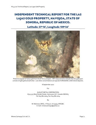
- 1. NI 43‐101 Technical Report, Las Lajas Gold Property Minera Camargo S.A. de C.V. Page | 1 IINNDDEEPPEENNDDEENNTT TTEECCHHNNIICCAALL RREEPPOORRTT FFOORR TTHHEE LLAASS LLAAJJAASS GGOOLLDD PPRROOPPEERRTTYY,, NNAAVVOOJJOOAA,, SSTTAATTEE OOFF SSOONNOORRAA,, RREEPPUUBBLLIICC OOFF MMEEXXIICCOO.. LLaattiittuuddee:: 2277ºº1166'',, LLoonnggiittuuddee 110099ºº2244'' Photomicrograph of native gold from the El Terco prospect. XRF measurements indicate that this gold grain consists of 95% gold and 5% silver. Low silver concentrations are typical of OROGENIC LODE GOLD deposits. 8 September 2010 For AUGUST METAL CORPORATION #313‐515 West Pender Street, Vancouver, B.C. Canada V6B 6H5 Tel: 604 681‐0004; Fax: 604 681‐0014 By M. Robinson, MASc., P.Eng Lic. # 23559, APEGBC. E‐mail: mineracamargo@yahoo.ca
- 6. NI 43‐101 Technical Report, Las Lajas Gold Property Minera Camargo S.A. de C.V. Page | 6 on the Las Lajas Gold Property ("the Property") in Sonora State, Mexico. The review is required by the TSX Venture Exchange as part of the documentation required for financing the Project. AGP has announced its intent to acquire 100% of the issued and outstanding shares in the capital of Goldzone Exploration Inc. (“Goldzone”), a private British Columbia corporation that currently owns the Lajas Project. The author has reviewed all of the technical information provided by Minera Goldzone S.A. de C.V. Sources of data include: A geological report by Glamis Gold (no author) dated 28 January 1995. A quarterly report for October‐December 1999 by Minera Phelps Dodge S.A. de C.V. The Report includes (i) a soil sample location plan by Phelps Dodge and electronic analytical data for most of the soil samples, (ii) level plans (33 m, 116 m and 225 m) and cross‐sections for 23.4 line kilometers (6 lines) of a smooth model inversion of an Induced Polarization‐Resistivity survey, and (iii) a geological map with rock samples located, but no analytical data for the rock samples. Five reverse‐circulation drill holes are also located on this map, but the drill hole logs are not available to the author. A Technical Report by B.J. Price Geological Consultant Inc. dated June 2004. A Technical Report by RH Russell and Associates Inc. dated April 2007. A Preliminary Report by Ing. J. Rafael Gallardo dated January 2009. Geochemical data and assay certificates for 580 rock samples and 1828 soil samples taken by Minera Goldzone S.A. de C.V. A 3 day field inspection was carried out by the author between 4 and 6 January 2010 in the company of Ing. J. Rafael Gallardo, Don José Gastelum Gomez, Jose Vargas Gaytan and Fermin Padilla Molina. In the field, a Niton XRF gun was used to identify sample locations, and the author collected 37 rock chip samples (numbers 25574‐ 25610) to verify the general tenor of the mineralization and characterize the alteration mineralogy. Structural measurements were collected at all measurable outcrops, and some drill‐hole collar locations were confirmed. An inspection of different locations on the recently completed soil grids was also completed, and the author has walked parts of these grids to ensure that sample locations are correctly reported and that appropriate material was sampled. In the office, the rock samples were re‐analyzed using a Niton GOLDD XRF analyzer, and inspected in the office using a Meiji binocular microscope and Terraspec SWIR spectrometer. Petrographic descriptions and analytical results are attached (LAJAS_MR_ROCKS_FINAL.xlsx). The samples were then re‐packaged and sent to ACME Analytical Laboratories in Guadalajara for Au‐Ag fire assays. 3.0 Reliance on other experts It was not within the scope of this report to examine in detail or to independently verify the legal status or ownership of the Property. Minera Goldzone has provided copies of all title documents, but not copies of Option Agreements or payment receipts. The author has reviewed the material made available, and checked the status of all 7 titles on the DGM website (http://www.economia‐dgm.gob.mx), and has no reason to believe that ownership and status are other than as has been represented, but determination of secure mineral title is solely the responsibility of Goldzone. 4.0 Property Description and Location The Las Lajas Gold Project is comprised of seven contiguous mining concessions totaling 16,310.4 Ha centered 15 kilometers north of the city of Navojoa, Sonora. The concessions are located using a cement monument that has been located by a legal mine surveyor in UTM co‐ordinates, NAD27 datum. The monument must have minimum dimensions of 0.6*0.6*1.0 meters, show the name of the concession, the surface area in the concession application, the office where the concession is registered, and the file number. The concession boundaries are located using polar co‐ordinates relative to the monument, and are not marked or surveyed. The Project concessions are controlled by Minera Goldzone S.A. de C.V. (“Minera Goldzone”), the Mexican subsidiary of Goldzone Exploration Inc. (“Goldzone”) a private British Columbia corporation. Three of the concessions are wholly owned by, and four of the concessions under option to, Minera Goldzone S.A. de C.V. All
- 7. NI 43‐101 Technical Report, Las Lajas Gold Property Minera Camargo S.A. de C.V. Page | 7 of the concessions remain valid for 50 years from the date of title as long as bi‐annual mining duties are paid in July and January of every year (Table 4.1), and minimum annual investment requirements are met (Table 4.2). After 50 years, the concession owner may apply for a second 50 year term. Investments made in excess of the annual minimum may be carried forward into the following year. Expenditures that meet the investment requirements are (Ley Minera, 1992): I. Direct mining works, such as ditches, wells, slashes, tunnels and all others that contribute to geological knowledge of the mining claim or the mining reserves; II. Drilling; III. Topographic, photogrammetric and geodesic surveys; IV. Geological, geophysical and geochemical surveys; V. Physical‐chemical analysis; VI. Metallurgical experimentation tests; VII. Development and rehabilitation of mining works; VIII. Acquisition, lease and maintenance of drilling equipment and development of mining works; IX. Acquisition, lease and maintenance of equipment for physical‐chemical laboratories and metallurgical research; X. Acquisition, lease and maintenance of work vehicles and for personnel transportation; XI. Works and equipment used for job safety and the prevention of pollution or restoration of the environment; XII. Facilities for warehouses, offices, workshops, camp sites, dwellings and services to workers; XIII. Acquisition, lease, construction and maintenance of works and equipment related to access roads, generation and conduction of electric energy, extraction, conduction and storage of water and infrastructure in general; XIV.Acquisition, lease and maintenance of equipment for mining, hauling and general services in the mine, and XV. Acquisition, lease, installation and maintenance of equipment for beneficiation operations and tailings dams. Table 4.1 Estimated Mining Duties owed for 2010 and 2011 on Las Lajas Property using rates for 2010. 1 USD=12.31 MXN Pesos. Title Number Concession Name Surface Area (Ha) Expiry Date 2010 1st 2010 2nd 2011 1st 2011 2nd 222432 Midas 2913.8 7‐Jul‐54 $ 45,805.52 $ 92,135.53 $ 92,135.53 $ 92,135.53 223475 Midas 2 8505.5 10‐Jan‐55 $ 133,705.93 $ 133,705.93 $ 243,596.55 $ 243,596.55 215004 El Peluchin 40.0 29‐Jan‐52 $ 2,528.80 $ 2,528.80 $ 4,450.80 $ 4,450.80 218814 Terco Dos 30.0 20‐Jan‐53 $ 948.60 $ 948.60 $ 1,896.60 $ 1,896.60 217412 El Terco 61.6 8‐Jul‐52 $ 6,857.27 $ 6,857.27 $ 6,857.27 $ 6,857.27 227555 El Triunfo 2 80.7 5‐Jul‐56 $ 613.63 $ 1,269.25 $ 1,269.25 $ 1,269.25 233931 Las Lajas 4678.7 23‐Apr‐59 $ 23,767.97 $ 23,767.97 $ 35,558.38 $ 35,558.38 TOTAL 16310.4 MEX PESOS $ 214,227.72 $ 261,213.35 $ 385,764.38 $ 385,764.38 CAD $ 17,396.52 $ 21,212.02 $ 31,326.28 $ 31,326.28
- 8. NI 43‐101 Technical Report, Las Lajas Gold Property Minera Camargo S.A. de C.V. Page | 8 Table 4.2 Estimated minimum annual investment requirements for 2010 through 2011 on Las Lajas Property using rates for 2006. 1 CAD=12.31 MXN Pesos. Title Number Concession Name Surface Area (Ha) Expiry Date 2010 2011 222432 Midas 2913.8 7‐Jul‐54 $ 576,276.64 $ 576,276.64 223475 Midas 2 8505.5 10‐Jan‐55 $ 1,684,994.90 $ 1,684,994.90 215004 El Peluchin 40.0 29‐Jan‐52 $ 3,922.00 $ 3,922.00 218814 Terco Dos 30.0 20‐Jan‐53 $ 1,470.60 $ 1,470.60 217412 El Terco (Explotacion) 61.6 8‐Jul‐52 $ 6,042.56 $ 6,042.56 227555 El Triunfo 2 80.7 5‐Jul‐56 $ 7,916.65 $ 7,916.65 233931 Las Lajas 4678.7 23‐Apr‐59 $ 135,670.39 $ 422,383.24 TOTAL 16310.4 MEX PESOS $ 2,416,293.73 $ 2,703,006.57 CAD $ 196,216.93 $ 219,499.66 According to a definitive agreement signed on June 24, 2010, the Vendor has granted August Metal Corp the right and option to acquire 100% of the issued and outstanding shares in the capital of Goldzone (the "Option”) for option payments over 5 years totaling $750,000 in cash and 5,000,000 shares. August will also issue the Vendor 5,000,000 warrants with each warrant entitling the Vendor to purchase an additional share of August at $0.20 for two years. In addition, August will also assume the option payments on the four concessions under option to Minera Goldzone, totaling USD$1,335,000over 6 years with $75,000 payable in 2010. August will also assume approximately $937,320 of Goldzone’s debt incurred in the course of acquisition, maintenance and exploration of the Property. August will satisfy $500,000 of the aforementioned debt through the issuance of 5,000,000 units at deemed price of $0.10 to the debtors, with each unit consisting of one common share and one warrant to purchase one additional common share at the price of $0.20 for two years. The balance of approximately $437,320 will be payable within two years. In the event that August satisfies the Goldzone debt but does not exercise the Option, August will have the right to acquire an undivided 51% legal and beneficial interest in the Property upon payment to Minera Goldzone of $1,000 plus any applicable Mexican taxes for a period of six months after any termination of the Option. The Property is subject to a 1.25% net smelter returns royalty (“NSR”) in favor of the Optionor. Two of the concessions are also subject to a 2% NSR in favor of the previous property owner, of which 1.25% can be purchased for $2 million. The other mineral concessions under option to Minera Goldzone are subject to a 1% or 1.5% NSR and all the NSRs can be purchased outright for a total of USD$1,950,000. The Las Lajas property area is sparsely populated. Small settlements occur at Las Lajas, Navomora and Barebampo. Much of the area serves as rangeland and a number of small dams seasonally store water. Surface land rights on the area to be affected by the proposed exploration are owned mainly by individual ranchers. There are no known environmental liabilities on the Property. Mechanized trenching, road building and exploration drilling may require a permit issued by Secretaría de Medio Ambiente y Recursos Naturales ("SEMARNAT") if the Project does not conform to the NOM‐120‐SEMARNAT‐1997 (Norma Oficial Mexicana NOM‐120‐SEMARNAT, 1997 [1998]). In this case, the minimum requirement is to submit the "Informe Preventivo”, a report that states the measures that will be used by the Company to minimize environmental impacts. Minera Goldzone’s Project conforms to the NOM‐120, and legally, Minera Goldzone does not require a drilling permit, nor is it required to file the Informe Preventivo with SEMARNAT (Acuerdo que modifica la Norma Oficial Mexicana NOM‐120‐SEMARNAT‐1997, [2004]). However, at any time, SEMARNAT and/or PROFEPA (the environmental enforcement authority) may inspect mining and exploration projects, and can request documentation from the Company showing compliance with environmental laws. Furthermore, many State Governments continue to require filing of the Informe Preventivo, and in forested areas, filing of the “Estudio Tecnico Cambio Justificado Uso de Suelo” as well. In practice, it is simpler to prepare and submit the Informe Preventivo, and Minera Goldzone submitted this Report to SEMARNAT 31 March 2010. As legally required by format of the Informe Preventivo, the written
- 17. NI 43‐101 Technical Report, Las Lajas Gold Property Minera Camargo S.A. de C.V. Page | 17 8.0 Deposit Types Three mineral deposit types have been observed on the Property: (i) orogenic lode gold‐quartz veins and silicified zones in the metamorphic rocks (e.g. El Terco and Peluchin), (ii) porphyry‐copper mineralization in foliated monzodiorite porphyries that intrude the metamorphic rocks (e.g. El Triunfo), and, (iii) open‐space filling, epithermal quartz veins and breccias, also hosted in the metamorphic rocks (e.g. Abejas Veins). 8.1 Orogenic Lode Gold Deposits Orogenic lode gold provinces are associated with accretionary orogens (accretion of one or more allochtonous terranes and oceanic crust to continental margin). Examples include: (i) the Russian Far East, (ii) Victoria, Australia, (iii) Shandong, China and, (iv) the North American Cordillera. In these orogens, significant gold deposits are located proximal to major accretionary boundary structures. They are mostly sited in lower to medium greenschist facies metamorphosed turbiditic rocks associated with, or underlain by, volcanogenic rocks of bimodal character (Bierlein and Crowe, 2000). Imaging of gold and other trace elements in pyrite from orogenic gold deposits shows that sulfur, arsenic and gold is introduced into the sedimentary host rock as syn‐genetic and diagenetic gold‐bearing arsenian pyrite, with the sulfur produced by a mixture of both hydrothermal reduction and bacterial reduction of seawater sulfate (Chang et al., 2010). During metamorphism, gold, arsenic and iron in the early pyrite is released to the metamorphic fluid, and re‐deposited as native gold with and within coarsely crystalline pyrite, arsenopyrite, and quartz in pressure shadows (fold noses) and structurally prepared sites (faults). Ore deposition occurs over a temperature range of 150ºC to 450ºC and a depth range between 2 km and 6 km (near the brittle‐ductile transition). The hydrothermal fluids are weakly saline (up to 6 wt% NaCl2), contain up to 50 mole % CO2, and the dominant gold‐carriers are bisulfide complexes (not chloride brines). Important exploration features of orogenic lode gold deposits are (Bierlein and Crowe, 2000): The principal ore mineral is native gold that contains less than 10% silver (the gold does NOT occur in electrum). Associated ore minerals include arsenopyrite and pyrite. Sometimes trace amounts of chalcopyrite, galena, sphalerite and stibnite occur, but the total sulfide content is usually less than 5%. Metal and mineral zoning is not significant. Gold and associated sulfides occur in quartz that can be associated with carbonate, feldspar, mica and tourmaline. The veins occur in high‐angle reverse faults (thrusts). These thrusts represent second order faults and splays which develop in the hangingwall of long‐lived translithospheric structures. Ore formation commonly correlates to a change from compressional to transpressional kinematics along these first‐ order structures. In Mexico, this change occurred in the Late Cretaceous. Wall‐rock alteration is extensively developed, and alteration mineral assemblages include: phyllic, argillic, propylitic and sodic. 8.2 Porphyry Copper Deposits Porphyry deposits are characterized by polymetallic sulfide and oxide ore minerals in veinlets and disseminations in large volumes of hydrothermally altered rock (on the order of 0.25 km3 ) . They occur in orogenic belts worldwide, and are genetically, spatially and temporally related to hypabyssal dioritic to granitic intrusions that are porphyritic and commonly have an aplitic groundmass. Porphyry deposits are grouped into classes based on the economically dominant metal in the deposit. In turn, metal assemblages are correlated to intrusion type and tectonic setting. At El Triunfo, surface geochemistry implies that copper is the principal ore metal. It occurs in veins and stockworks that are hosted in the porphyritic phase of a monzodiorite pluton. Alteration related to porphyry systems is complex, and is affected by at least four major variables: (i) temperature, (ii) pressure, (iii) chemical composition of the ore fluid, wall rock and external fluids and (iv) structural style (e.g. veins or breccias). In general, there can be: (i) a potassic, higher temperature core marked by secondary biotite
- 18. NI 43‐101 Technical Report, Las Lajas Gold Property Minera Camargo S.A. de C.V. Page | 18 and K‐feldspar, (ii) phyllic alteration assemblages marked by muscovite and pyrite that reflect higher water‐rock ratios and (iii) distal propylitic alteration zones that contain chlorite and epidote. Condensation of hot vapor in rocks overlying porphyries results in the formation of extensive lithocaps of quartz, pyrite and clays. 8.3 Epithermal Silver‐Gold Deposits Most of the known economic epithermal precious metal deposits occur in Tertiary volcanic rocks, both in arcs and in post‐arc extensional settings. Important characteristics of epithermal deposits include: High grades of Au and Ag. Anomalous concentrations of Sb, As, Hg, Pb, Zn, Cu and other metals. Ore minerals include native gold, electrum, acanthite, tetrahedrite, ruby silver, sphalerite, galena and chalcopyrite. Mineral and metal zoning is significant from base metal‐rich roots to gold rich bonanza zones to silver‐ rich zones above the bonanza zones. Gangue minerals include quartz, calcite, barite, clay, sericite, chlorite and epidote. Most known deposits are vetiform, but stockworks, breccias and disseminated deposits also occur. They are associated with significant alteration zones (“color anomalies”) and lithocaps. Exposure of ore zones is usually poor as the dominant dimension is down‐dip or down plunge of the ore shoot. The down‐dip extent of ore zones ranges from 200 meters on low sulfidation systems to more than 1200 meters in intermediate sulfidation systems. Minerals are deposited in open spaces, and have characteristic textures (e.g. colloform banded and cockscomb textures are typical). Alteration mineral assemblages indicate temperatures of deposition between 100 and 300ºC. Typical alteration types include: (i) proximal propylite, (ii) distal zones of clay alteration and (iii) unmineralized, but related zones of steam‐heated alteration or “lithocaps”. Several sub‐classes of epithermal deposits are recognized: (i) low sulfidation, (ii) intermediate sulfidation and (iii) high sulfidation. Having said that, different classes of deposit may occur in the same camp, and some styles may overprint earlier styles. In the Abejas Veins, textures and mineral assemblages typical of intermediate sulfidation epithermal deposits have been observed. 9.0 Mineralization 9.1 El Terco Orogenic Au El Terco is a gold‐rich silicified zone that trends NNE and dips moderately WNW. Mineralization has been partially exposed over an area 600 meters long and 200 meters wide by numerous shallow artisanal mines and a 30 meter deep shaft (Pozo del Gringo). Gold occurs in grey, silicified zones hosted in fractured quartz‐chlorite schist with thinly bedded limestone. The quartz is massive, grey and clear, and appears to mainly replace the carbonate component of the metasedimentary rocks. Open‐space filling textures are notably absent. On surface, sulfides are oxidized, but some fresh rock in the dump next to Pozo El Gringo contains about 3% disseminated arsenopyrite. Minera Goldzone has collected 88 rock chip‐channel and grab samples from El Terco. The best overall result is 7.04 g/t Au across 1 m from a sample just west of Glamis percussion hole #30. Of the 88 samples, 13 (15%) contain more than 1 g/t Au, and the average result of all 88 samples was 0.64 g/t Au. Minera Camargo collected 11 rock chip‐channel and grab samples from El Terco, and these verify the general tenor of Goldzone's results. The best result from Camargo's sample set was 2.94 g/t Au across 1.2 meters from Prospecto Don Jose (sample 25574, Fig. 9.1), and the average result of all 11 samples was 1.0 g/t Au. East of El Terco, sub cropping green oxides (possibly chlorargyrite) in hematitic quartz boulders yielded markedly anomalous silver values of 1285 g/t silver.
- 20. NI 43‐101 Technical Report, Las Lajas Gold Property Minera Camargo S.A. de C.V. Page | 20 9.4 Abejas Epithermal Ag‐Au Spectacular, easterly trending intermediate sulfidation epithermal quartz veins and breccias outcrop discontinuously over a 1.3 kilometer long strikelength about 1.8 kilometers east of the El Terco monument. The veins and breccias are hosted in thinly bedded limestones and intercalated schists that strike easterly and dip moderately to the north. In general, the mineralization is guided by the stratigraphic orientation, but it is not confined to bedding/foliation planes. There are two historic mine shafts located along the central 275 meters of an ore shoot where most of the quartz veining and brecciation seems to be focused. Minera Goldzone has collected 8 rock samples from the Abejas Vein. The average result of these is 70 g/t Ag, 0.66 g/t Au, 1.3% Zn, 0.3% Pb and 0.05% Cu. Minera Camargo sampled the dumps from the two shafts as the dump material is fresher than the surface outcrops, and would hopefully be more representative of the material targeted by the miners. The westernmost sample contains 1103 g/t Ag and 0.79 g/t Au (sample 25609), and the easternmost sample contains bonanza grades of 46.87 g/t Au and 56 g/t Ag (Figs 9.9 and 9.10; sample 25610). SWIR spectrometry of samples from the Abejas and other epithermal style veins to the north shows that the alteration mineralogy of the samples is mainly illite, as would be expected in a high‐grade vein, although alunite (aluminum sulfate) was found in one sample, and barite (barium sulfate) was found in the sample from the eastern dump on the Abejas Vein. The presence of sulfates with the epithermal ores implies that the ore fluids had a high oxygen fugacity, a characteristic of hydrothermal fluids fluid with a magmatic component. The presence of alunite in veins hosted in schist implies that at least some fluids were acid rather than neutral. Fig. 9.1. Prospecto Don Jose on the El Terco structure. Check sample 25574 yield 2.94 g/t Au across 1.2m Fig. 9.2. Photomicrograph of native gold from the dump below sample site 25583. X‐ray measurements of the gold show that it consists of 95% gold and 5% silver. Low silver contents are characteristic of orogenic lode gold deposits.
- 21. NI 43‐101 Technical Report, Las Lajas Gold Property Minera Camargo S.A. de C.V. Page | 21 Fig. 9.3. El Peluchin Stope. Fig. 9.4 Boulder with high‐grade gold and silver. Check sample 25593 contains 86.09 g/t Au and 277 g/t Ag. Fig. 9.5 Panned gold from a crushed sample of 25593. Fig. 9.6 Silicified schist with values of 0.37 g/t Au and 27 g/t Ag across 0.8 meters (sample 25587). Fig. 9.7.El Triunfo Porphyry Cu prospect. Mineralization consists of foliation parallel chalcocite and chrysocolla veinlets hosted in propylitic altered, feldspar porphyritic monzodiorite. Fig. 9.8 Epithermal quartz with characteristic brecciation and open‐ space filling textures hosted in graphitic schist from a structure 1.4 kilometers northwest of the Abejas Vein. Silver and gold values for this sample were below detection (sample 25607), but the SWIR spectra show that this sample contains alunite (aluminum sulfate). Fig. 9.9 Shaft on the Epithermal Abejas Vein. A sample of the dump yielded bonanza grade results of 46.87 g/t Au and 56 g/t Au (sample 25610). There is a large bee's nest in this shaft. Fig. 9.10 Photomicrograph of bladed barite (barium sulfate) in sample 25610. 10.0 Exploration
- 22. NI 43‐101 Technical Report, Las Lajas Gold Property Minera Camargo S.A. de C.V. Page | 22 10.1 Geochemistry In 1999, Minera Phelps Dodge Mexico collected 1799 soil samples on lines spaced 200 meters apart with individual samples spaced at 50 meters along the lines. Of these, multi‐element and gold concentration data are available for 1535 samples. Between 2008 and 2009, Minera Goldzone collected 580 surface rock chip‐channel samples from mineralized outcrops on the Property. In late 2009, Minera Goldzone completed 1877 new soil samples in two new grids on targets defined by the rock sampling campaign. Summary statistics for soils and rocks are in Tables 10.1 and 10.2 respectively. The author analyzed the population statistics for gold in soils, and determined that values below 93 ppb Au are probably non‐anomalous, and reflect the high background gold values of the metasedimentary bedrock. Moderately anomalous gold values range from 94 ppb to 235 ppb Au, and markedly anomalous gold values are higher than 235 ppb Au. An interpretation showing the gold anomalies is plotted in Fig. 10.1. This map shows that the largest continuous anomaly for gold is centered north of El Peluchin in the area that was drill‐tested by Phelps Dodge. Other important gold anomalies are defined at Peluchin West (the Goldzone grid area) and west of El Terco. Table 10.1 Summary statistics for 3412 soil samples collected on the Property between 1999 and 2009. Au (ppb) As (ppm) Sb (ppm) Cu (ppm) Pb (ppm) Zn (ppm) Maximum 1855 1400 66 2398 350 1799 Arithmetic Mean 36 87 3 56 13 91 Standard Deviation 72 96 3 56 18 74 50th percentile 20 63 2 51 10 83 75th percentile 38 110 3 71 15 107 90th percentile 72 172 5 93 22 135 95 th percentile 106 249 7 109 33 166 99 th percentile 290 466 14 170 80 344 Table 10.2 Summary statistics for 580 rock samples collected on the Property by Minera Goldzone between 2008 and 2009. Au (g/t) As (ppm) Sb (ppm) Ag (g/t) Cu (ppm) Pb (ppm) Zn (ppm) Maximum 88.70 32800 1810 331 23300 16200 39500 Arithmetic Mean 0.45 559 12 3 188 142 293 Standard Deviation 3.90 2166 86 19 1241 905 2484 50th percentile 0.02 60 3 0 35 8 36 75th percentile 0.07 214 8 1 70 19 71 90th percentile 0.42 890 16 2 169 60 155 95 th percentile 1.25 2520 28 5 388 155 278 99 th percentile 7.31 10280 94 55 3919 5000 4639
- 27. NI 43‐101 Technical Report, Las Lajas Gold Property Minera Camargo S.A. de C.V. Page | 27 11.0 Drilling To date, neither Minera Goldzone nor August Metal Corporation has completed any drilling. 11.1 Percussion Drilling Minera Glamis completed 1420 meters of percussion drilling in 48 twenty‐two to thirty meter long, vertical holes over an area 500 meters long by 300 meters wide centered on the El Terco claim post between 10 August and 2 September 1994 (Fig. 11.1). Cuttings were collected every three meters and bagged for gold assay. Descriptions of the drilling and sampling procedures are not otherwise documented in their Report (Minera Glamis, 1995). A summary of the results is in Table 11.1, and the best overall result was 12 meters of 1.86 g/t Au in Hole 40. The true with of these intercepts is not known for the reasons detailed in Section 12.3. Table 11.1 Summary of results from the 1994 percussion drilling campaign (Minera Glamis, 1995) Hole ID From(m) To(m) Interval* Au g/t) 2 12 15 3 0.32 4 0 3 3 4.00 13 27 30 3 1.85 14 0 3 3 1.19 19 6 12 6 0.58 19 18 27 9 0.37 30 0 6 6 0.95 35 9 12 3 0.53 38 21 27 6 1.68 39 21 30 9 1.73 40 15 27 12 1.86 41 27 30 3 0.29 46 0 3 3 0.38 48 15 18 3 0.62 49 3 6 3 0.40 51 6 12 6 0.70 53 15 21 6 0.29 *The true width of these intercepts is not known for the reasons detailed in Section 12.3.
- 31. NI 43‐101 Technical Report, Las Lajas Gold Property Minera Camargo S.A. de C.V. Page | 31 Summary distribution statistics for the Phelps Dodge and the Minera Goldzone soil samples are similar for gold, arsenic and base metals. Therefore, the data are believed to be representative and reliable (Section 14). 12.2 Rock Samples An area of 42.8 km2 of the Property has been prospected by Minera Goldzone with rock geochemistry. Several types of rock samples were used in the evaluation of the Property, and these are listed in Table 12.1. For all types of samples, about 2 kilograms of rock chips were collected in a double‐bagged plastic sample bag with a numbered tag. Samplers were instructed not to wear metal jewelry to avoid sample contamination. Table 12.1 Types of rock samples used to evaluate mineral occurrences on the Property. SAMPLE TYPE DESCRIPTION AND COLLECTION METHOD Grab Samples A sample taken from an outcrop, but not oriented across a structure, and not necessarily representative. Float Samples A rock sample from loose material, usually stream boulders or colluvium. Dump Samples Material collected from a mine dump. Chip Samples Oriented samples taken across a width by chipping pieces of rock approximately every 10 cm. Chip‐Channel Samples Oriented samples cut across a representative part of a mineralized structure using a sledgehammer and chisel to form a continuous channel. The author of this Report has collected 37 rock samples to verify Goldzone's results. Summary distribution statistics for the Minera Camargo and the Minera Goldzone rock samples are similar for gold and silver. Minera Camargo did not measure base metal concentrations as they are not that relevant to the value of the mineralization. Therefore, the rock assay data are believed to be representative and reliable (Section 14). 12.3 Percussion Drill Samples Minera Glamis (1995) did not document their drilling or sampling procedure(s). Nor did they specify what type of machine was used to do the sampling, or who the contractor was. Nonetheless, the information in their Report is consistent with using an air track (?) drill. Air track drills are designed for drilling 30 meter long blast holes for quarrying operations, and are not designed for quantitative geological sample collection. Nonetheless, the method is very fast, and provides qualitative, near‐surface information that can be used to design drill programs for quantitative mineral resource and reserve estimation. The information is qualitative for the following reasons: 1. A set sample length is used, so the boundaries of the mineralization are not known precisely. 2. The cuttings are lifted to surface using air or some other drilling fluid. When coarse gold is present, the circulation of the fluid will cause it to settle to the bottom of the drill hole. Therefore, the gold assays of the cuttings under‐report the amount of gold actually present. 3. Material from the upper parts of the hole can fall into the hole and contaminate the sample. 12.4 Reverse Circulation Drill Samples Phelps Dodge did not document their drilling or sampling procedure beyond specifying that the holes were drilled with a reverse‐circulation drill rig (Thoman and Rodriguez, 1999). They did not specify who the contractor was, what drilling rates were achieved, are whether or not the drill holes intercepted the water table. The summary files in the back of Russell's 2007 reports show that the sampling interval selected was 2 meters, which is large for a precious metal target. No information is available about what sampling procedures were used, or how the assay splits were prepared. Reverse circulation drilling is a percussion drill testing method, and the information is semi‐ quantitative for reasons 1 and 2 in Section 12.3. 13.0 Sample Preparation, Analysis and Security No information regarding sample preparation, analysis or security is known for the Minera Glamis samples (Minera Glamis, 1995).
- 33. NI 43‐101 Technical Report, Las Lajas Gold Property Minera Camargo S.A. de C.V. Page | 33 0.01 0.10 1.00 10.00 AU_PPM Fig. 14.3 Box plot for Goldzone gold concentration in rock. Fig. 14.4 Box plot for Minera Camargo gold concentration in rock. Camargo's check samples were taken in areas of known gold mineralization, so the median of the distribution is higher than that of the Goldzone rocks. 15.0 Adjacent Properties There are 4 third‐party owned concessions inside the Las Lajas Property boundary. While some of the work prior to 2000 overlaps these Properties, neither the author nor Minera Goldzone has done much work on these other concessions. 16.0 Mineral Processing and Metallurgical Testing No metallurgical testing has been done. 17.0 Mineral Resource Estimates To the author’s knowledge, there is no gold resource or reserve calculated for the Property. However, several significant drill hole intercepts obtained by Minera Glamis in 1994 and Phelps Dodge in 1999 suggest that there is potential to outline a gold resource(s). 18.0 Other Relevant Data and Information The author of this report is not aware of any additional information, the omission of which would be misleading. While there is believed to be considerable additional geological, geophysical and geochemical information concerning the Properties that may be in the possession of Phelps Dodge or subsidiaries or partners, in the author’s judgment sufficient information has been supplied for this Technical Report to determine that the Property is of merit. 19.0 Interpretation and Conclusions Las Lajas is a highly prospective gold property located on or near the boundary between the autochthonous Cortez Terrane and the allochthonous basement of the Tahue Subterrane of the Guerrero Superterrane. While regional mappers consider Las Lajas to be part of the Cortez Terrane (Centeno‐Garcia et al., 2008), locally mapped lithologies might be more typical of over thrust basement of the Tahue Terrane. In either case, accretionary orogens (Bierlein and Crowe, 2000) are particularly prospective for Orogenic Lode Gold deposits. The critical ore‐forming process is scavenging of syn‐sedimentary gold and other metals by deeply circulating metamorphic fluids, and deposition of gold in structurally prepared sites (faults and fold noses) related to deformation and orogenic uplift. In this part of Mexico, the mineralizing orogeny started in the Late Cretaceous and continued episodically into the Tertiary. The later stages of the orogeny are related to porphyry copper and epithermal mineralization which can overprint the earlier stage of orogenic gold deposit formation. At Las Lajas, mineral showings related to all of these events occur, although they are not yet known to spatially overlap. The Phelps Dodge soil geochemistry survey has provided an extremely useful database that can be used to guide the next exploration campaign. The results were combined with Goldzone's soil surveys to generate a "gold anomaly map".