SlideShare a Scribd company logo
1 of 13
Download to read offline
 
Recreational swimming area Environmental Health and Safety Survey (EHSS) 
checklist ​(Brokers’ Bay)
Identification 
Site Name:​ Brokers’ Bay 
Address: ​ 1450 Creekside Dr, Vancouver, BC V6J 5B3 (Building) 
Responsible Authority: ​Vancouver monitoring hub - Swim Drink Fish ​Telephone: ​604.674.7444  
E-mail:​ ​katie@swimdrinkfish.ca 
Person(s) Conducting Survey:​ Katie Moore 
Date:​ May 29, 2019 ​Time: ​ 14:45 
 
Background Information 
Water Body Type: Marine/ Harbour 
Dimensions of Site: Length (m): 223 m  Width (m): 248 m  
Perimeter: 870 m  Area: 4.83 ha 
Number of Sampling Sites: 5  
Water Temperature High: 24°C Water Temperature Low: 6.5°C 
Average Air Temp: 11.8°C 
Prevailing Winds Direction: ESE  Avg. Speed: 6 km/h 
 
Figure 1. Brokers’ Bay location outlined in green with sampling sites shown in yellow. 
Adapted from the Guidelines for Canadian Recreational Water Quality: Third Edition
1 
 
Figure 2. Monthly mean temperature and mean precipitation for 2018 from Vancouver Harbour 
CS weather station (​Government of Canada​, 2019). 
 
Figure 3: Yearly wind direction. Data collected from the False Creek Fuel station and published 
on ​Windfinder. 
Prevailing Winds Direction: ESE  Avg. Speed (km/h): 6 
SWIM DRINK FISH | 2
Prevailing Currents Direction: Tide dependent Avg. Speed (km/h): Tide dependent 
Precipitation Data for 2018 
Rainfall Total (mm) in 2018: 1721.3  
24-h High (mm): 77.5 (December 13)  
 
 
Figure 4. Total precipitation (mm) per month in 2018 from Vancouver Harbour CS weather station 
(​Government of Canada​, 2019). 
 
Surrounding Land Uses:  
● Urban ✓  
● Residential ✓  
● Commercial (specify): commercial fishery ✓  
● Harbour ✓  
● Recreational ✓
Brokers’ Bay and the surrounding land is located on the traditional unceded territories of the 
Coast Salish People including the Tsleil-Waututh (səl̓ilw̓ətaʔɬ), Squamish (Sḵwx̱wú7mesh 
Úxwumixw) and Musqueam (xʷməθkʷəy̓əm) Nations. 
 
SWIM DRINK FISH | 3
False Creek was historically a much larger tidal flat area up until 1913 when the eastern half of the 
flats were filled in to make Vancouver’s main railway station, now known as Pacific Central. After 
the railway station was built and up until the 1950's, False Creek was the industrial heartland of 
Vancouver. The land surrounding False Creek has now been highly urbanized with commercial 
and residential buildings. Vancouver Coastal Health has classified False Creek as not suitable for 
swimming (primary contact with water) and advises only secondary contact recreation activities 
“that result in regular wetting of limbs, but swallowing of water is unusual” be permitted in False 
Creek (ie. canoeing, kayaking, sailing, fishing) (​VCH​, 2019).  
 
Granville Island was built for industrial purposes in the early 1900s, it used to be called Industrial 
Island. Several factories were established mainly serving the mining and forestry industries. 
During World War II, Wright’s Canadian Ropes on the island was Canada’s biggest manufacturer 
of heavy-duty wire rope. The government later invested millions to make the island a recreational 
area of the city (1970s). Until then, Granville Island did not have any green space. The Island’s 
public market was established in 1979. 
  
Brokers’ Bay is located at the South Western side of Granville Island between Foreshore walk 
and the Fisherman’s Wharf, owned by False Creek Harbour Authority.  
The commercial buildings and spaces nearby include the following: 
● False Creek Harbour Authority (commercial fishing boats and pleasure crafts) 
● Maritime Market & Marina Ltd 
● Granville Island Public Market 
● Boat Yard 
● Tony’s Fish and Oyster Cafe  
● Vancouver Theatre Sport League  
● Fraser Yacht Sales  
● Blue Pacific Yacht Charters  
● Cooper Boating  
● Bluewater Rigging  
● Wilson Boating  
● Vancouver Water Adventures  
● Ecomarine Paddlesport Center  
● Specialty Yacht Sales  
● Skookum Yacht Services  
● Bridges Restaurant  
● Go Fish Restaurant  
● Seawall with biking and walking paths 
● Vancouver Fish Company 
SWIM DRINK FISH | 4
A. Microbiological Hazards Assessment 
Potential Sources of Faecal Contamination 
● Stagnant water ✓ 
● Municipal Sewage Discharges ✓   
● Stormwater Drains/Discharges ✓ 
● Combined Sewer Overflows (CSOs) ✓ 
● Other Discharges of Faecal Wastes (List): ✓ 
○ Boat discharges 
 
Stormwater Runoff from: 
● Runoff from surrounding area i.e., roads, walkways, and other impermeable 
surfaces ​✓
● Boat yards ​ ✓ 
Other Environmental Sources:  
Environmental Sources  Category (None, Low, Med, High) 
Birds (e.g., gulls, ducks, geese, other)   Medium 
Other wild animals: Fish/ seals/cetaceans  High 
Pets   Low 
Swimmers  None 
Table 1. Summary table of wildlife for Brokers’ Bay 2018 sampling season (July 19- 
December 27).
Wildlife Count
Cormorant 17
Seagull 67
Duck 15
Crow 22
Seal 9
Swallow 2
SWIM DRINK FISH | 5
Heron 2
Dead Cormorant 1
Table 2. ​Summary table of people recreating for Brokers’ Bay 2018 sampling season 
(July 19- December 27).
People Count
Zodiak 3
Rowing Boat 6
Kayak 5
Standup Paddle Board 8
Motor Boats 2
Sea-doo 2
Paddler 5
 
Items for Consideration during the Microbiological Hazards Risk Assessment: 
● Proximity of potential contamination sources to the swimming area.  
The potential area where individuals might swim or fall in the water is relatively close to the CSO 
located on the north side of Granville Island, next to the ferry dock location. It is also in close 
proximity to boats anchored in the marina.  
 
● Potential for contamination sources to have an impact on the swimming area (including an 
indication of their risk priority: Low, Medium, High).  
Due to the presence of a CSO into this part of False Creek and all the boats anchored in the 
marina, there is a ​high​ potential for the swimming area to be impacted by contamination sources.  
 
● Evaluation of water quality according to historical microbiological data (e.g., frequency of 
exceedances of the guideline values for the recommended indicators of faecal 
contamination [e.g., continuous/periodic/sporadic]).  
According the sampling completed by Fraser Riverkeeper from 24 sample events (July 13- 
December 27th) in 2018, Brokers’ Bay passed the Canadian Guidelines for Recreational Water 
Quality 52% of the time and failed the standards 40% of the time. 
 
 
SWIM DRINK FISH | 6
Table 3. Fraser Riverkeeper 2018 sampling results for Brokers’ Bay taken from Swim Guide. 
Year  # of Sample Events  Pass  Fail 
2018  25  92%  8% 
 
● Discharges: Assessment of such factors as volume, flow rate, treatment type, applicable 
indicator standards, periodicity (continuous, sporadic) and predictability.  
The discharges into the Brokers Bay site could include untreated sewage from the CSO located 
on the north side of Granville Island, along with other wastewater, and stormwater runoff. 
According to the Effluent Regulatory Reporting Information System (ERRIS) and the Wastewater 
Systems Effluent Regulations (WSER), 75,600 m3 of raw effluent were deposited via the Granville 
CSO point in 2017 (45,200 m3 in 2016 and 99,500 m3 in 2015). 
 
● Effects of rainfall: Levels triggering contamination events and typical event duration.  
CSOs in Vancouver flow more frequently in the winter months (October through April) when there 
are significant storm events that result in higher risk of contamination to the water body.  
 
● Assessment of swimming area circulation: Effect of onshore winds, tides, currents, flow 
patterns in transporting faecal contamination to and entrapping it within the swimming 
area.  
Brokers’ Bay is a sheltered area, with slow moving surface currents. Entrapping of faecal 
contamination is at a high risk considering the area is densely populated with boats and the flow 
is tide dependent. 
 
● Animals and birds: Assessment of their types, numbers and dropping​s.  
Environmental surveys from 2018 documented 73 animals in total: mostly birds but also a few 
seals. Due to insufficient information concerning the link between wildlife and water 
contamination, the impact the birds and animals have on the water quality is unknown.  
 
● Impact of swimmers on water quality—numbers, ages.  
No swimmers have been observed in the water. However, Brokers’ Bay is the launching area of 
several water recreational rentals companies. 19 kayaks, SUP etc. leaving or returning from the 
Bay were observed on Thursday mornings from July to December 2018.  
 
● Assessment of potential barriers: Barrier types and points at which they may be applied to 
reduce the impact of the contamination source and/or swimmer exposure. 
The presence of the Granville Island’s CSO as well as possible boat discharges in the marina are 
to be considered as a potential source of contamination. Solutions include the implementation of 
decentralized urban best management practices (BMP) for stormwater control which include: 
● Infiltration practices; 
● Pocket wetlands; 
SWIM DRINK FISH | 7
● Porous pavement; 
● Rain barrels/cisterns; 
● Rain gardens; 
● Soil amendments; 
● Tree box filters; 
● Vegetated (green) roofs;  
● Vegetated swales; 
● Pump out stations  
This helps reduce the stormwater volume and improves stormwater quality, thus reducing the 
likelihood of CSOs releasing into the site and also improving the water quality of the potential 
discharges.   
 
B. Chemical Hazards: 
As is the rest of False Creek, Brokers’ Bay was formerly an industrial hub. The potential exists for 
chemical contamination from historic industrial waste that might remain in the area. However, 
more research and sediments testing are required to confirm this factor.
Potential Sources of Chemical Contamination:
Commercial/Industrial Discharges: high potential 
● Marinas ✓  
● Motorized Watercraft ✓ 
  
Stormwater Runoff From:  
● Urban Areas ✓  
● Areas subject to Pesticide Application: yes 
● Areas subject to Fertilizer Application: yes 
Items for Consideration during the Chemical Hazards Risk Assessment:  
● Proximity of potential contamination sources to the bathing area. 
Motorized and non motorized vessels dock in the bay. Even though this is not a bathing area, 
there are several paddling and kayaking companies on Granville Island offering rentals, most 
notably Ecomarine and Vancouver Adventure Sports. This makes Brokers’ Bay a very popular site 
for recreational water activities.  
 
● Potential for contamination sources to have an impact on the swimming area 
(including an indication of their risk priority: Low, Medium, High). 
The potential for contamination sources to have an impact on the swimming area is ​high​.  
 
● Discharges: Assessment of such factors as volume, flow rate, treatment type, 
periodicity (continuous, sporadic) and predictability.  
The impacts that the motorized boats have are unknown. No research exists assessing factors 
such as volume, flow rate, treatment type, periodicity, and predictability.  
 
SWIM DRINK FISH | 8
● Effects of rainfall: Levels triggering contamination events and typical event duration.  
Due to Brokers Bay’s proximity to parking lots on Granville Island, and roadways, the impacts of 
rainfall and the subsequent runoff is high. The levels required to trigger a contamination event is 
unknown, as well as the typical event duration. Swimmers are advised to remain out of the water 
for 24hrs after a rainfall event.  
 
● Assessment of swimming area circulation: Effect of onshore winds, tides, currents, 
flow patterns in potentially transporting chemical contamination to and entrapping it 
within the swimming area.  
Brokers’ Bay is a sheltered area, with slow moving surface currents. Entrapping of faecal 
contamination is at a high risk considering the area is densely populated with boats and the flow 
is tide dependent. 
 
False Creek is saltwater and thus influenced by marine tides. Vancouver experiences mixed 
semidiurnal tides which means there are two high and two low tides with different sizes each 
lunar day. The tides are also affected by Spring tides which occur about twice a month at new 
moon and full moon which are higher and stronger tides and neap tides during first and last 
quarter of the moon which are lower and weaker tides. The flushing rate of the tides in False 
Creek is not only affected by daily high and low tides but the cycle of the tides in the monthly 
lunar cycle. 
 
● Motorized watercraft: Assessment of their types and numbers. 
The two marinas located in Brokers’ Bay, the False Creek Harbour Authority and Maritime Market 
& Marina Ltd, both hold a large variety of both motorized and non-motorized boats. Fisherman’s 
Wharf also houses multiple commercial fishing vessels. Exact numbers are unknown. 
 
● Assessment of potential barriers: Barrier types and points at which they may be 
applied to reduce impact of the contamination source and/or swimmer exposure.  
Refer to barriers and techniques mentioned in the microbiological hazards assessment section. 
C. Other Biological Hazards  
Other Biological Hazards Known to Affect the Recreational Water Area (Presence may be 
continuous, seasonal or sporadic.)
● Cyanobacterial Blooms - unknown  
● Schistosomes (Swimmer’s Itch) unknown 
● Large Numbers of Aquatic Plants: limited 
Items for Consideration during the Biological Hazards Risk Assessment: 
● Seasonal nature of the hazard: continuous, annual, sporadic. 
Additional research is required to assess the seasonal nature of biological hazards. 
 
● Presence of contributing factors (as applicable): water conditions, local geography, 
temperatures, nutrient levels, presence of appropriate host species. 
SWIM DRINK FISH | 9
Additional research is required to assess the presence of contributing factors of biological 
hazards in the site.  
 
● Assessment of potential barriers to control hazard and/or reduce human exposure in 
areas/during times of increased risk. 
Until the biological hazards are assessed, an assessment of potential barriers to control the 
hazard is not feasible.  
D. Physical Hazards and Aesthetic Considerations
Subsurface Hazards:  
Steep Slopes or Dropoffs ✓  
Depths greater than 4.5 m ✓  
 
Water Conditions:  
Strong Currents or Rip Tides - no  
Undertows - no 
Other: (Select from None Low Med High)  
Litter on Beach ✓ Medium 
Floating Debris ✓ Medium 
Broken Glass or Other Sharp Objects ✓  Low 
Medical Wastes ✓  None 
Sewage waste ✓ None 
Seaweed/Algae on Beach ✓  Medium  
Microplastics ✓ Medium potential 
 
SWIM DRINK FISH | 10
 
Figure 5. Litter counted during the sampling events from July 19 to December 27, 2018 at 
Brokers’ Bay.  
 
Vehicles Permitted on Beach or Near Bathing Area:  
Automobiles - ✓ 
Boats/Watercraft ✓ Specify: Cruise ships, restaurant boats, party boats, sea-doos, personal boats, 
commercial boats, canoes, kayaks.  
 
Items for Consideration during the Resulting Risk Assessment:  
● Assessment of the physical characteristics of the beach and their potential impacts on 
safe enjoyable use of the area. Includes evaluation of physical layout (geography, 
topography), composition of shoreline and bottom material, influence of existing 
structures.  
The shoreline area is a paved area. The water level at Brokers’ Bay is 1 to 2 m below the 
shoreline (depending on the tide). There is an access to the water via the dock. The depth of the 
water is > 5 m, and the bottom material is likely accumulated sediments, aquatic plants, and 
possible contaminants from the industrial era. 
 
● Assessment of potential risks posed by specific hazards/factors in causing injury or 
illness or otherwise interfering with the enjoyable use of the area.  
The drop off from the shoreline into the water at low tide can represent potential risks to the 
public using the space. There is no beach for people to access the water easily.  
 
SWIM DRINK FISH | 11
● Shoreline and water free from obstructions and of sufficient clarity to permit viewing of 
persons who may be in distress.  
The shorelines and water are obstructed in all parts of the site because of the dense presence of 
boats, easily hiding a person in distress.   
 
● Assessment of the nature and origin of litter and floating debris.  
The litter at Brokers’ Bay most likely comes from the streets and the variety restaurants located 
around the public market. During the summer months, it is common to see people eating outside 
by the water, on the picnic tables or on the waterfront benches. A large quantity of the litter 
observed was food related.  
 
● Applicable physical and aesthetic parameters (pH, temperature, turbidity, colour, 
clarity, litter) in agreement with recommendations given in the Guidelines for Canadian 
Recreational Water Quality.  
Physical parameters was not consistently recorded during the 2018 sampling events. 
Temperature and water clarity were recorded consistently using a thermometer and Secchi disk, 
however the other parameters are based on subjective observations. Tidal data was not 
collected, which would have an effect the Secchi depth measurements.  
 
Table 4. Physical parameters ​for Brokers’ Bay 2018 sampling season (July 19- December 
27). 
Parameter  Observations 
Temperature (°C)  Min: 6.5 Max: 24 Average: 13.8 
Turbidity   Unknown 
Colour  Average colour: dark green  
Clarity (m)  Average visibility observed with the Secchi disk: 3.4 m 
Odour  Sometimes sewage or fishy odour in the summertime, at low tide  
Litter   Medium presence 
 
 
● Assessment of potential barriers to control hazard and/or reduce human exposure in 
areas/during times of increased risk.  
Refer to barriers and techniques mentioned in the microbiological hazards assessment section. 
 
E. Facilities and Safety Provisions 
Facilities​: 
Toilets #: 4 (West side of Granville Island); 4 (Fisherman’s Wharf)  
Showers #: 2 (Fisherman’s Wharf) 
SWIM DRINK FISH | 12
Drinking Water Fountains #: 2 (West side of Granville Island) 
Litter Bins #: 4 
Access for Persons with Disabilities: yes 
 
Safety Provisions:  
Lifeguard Stations #:  0 Lifesaving Equipment #: 0 
Emergency Telephone #: 0 First Aid Stations #: 0 
 
Signs/Communication Materials:  
Beach Posting/Suitability for Swimming - no  
Emergency Contact Information - Yes (Fisherman’s Wharf) 
 
Formal Procedures or Reporting Mechanisms in Place to Deal with:  
Municipal or Industrial Spills/Discharges/Treatment Bypasses - yes (Fisherman’s Wharf) 
Waterborne Disease Outbreaks - no  
Swimmer Injuries - no 
 
Items for Consideration during the Resulting Risk Assessment: 
● Assessment of the adequacy of facilities and safety provisions. 
The facilities in the area are limited, as there is no official place to swim.  
 
● Evaluation of signs and other materials for public communication: Message clear and 
concise, signs placed in locations highly visible to the public. 
No signs are posted pertaining to swimming advisories. 
SWIM DRINK FISH | 13

More Related Content

What's hot

Surfers Against Sewage Fact File (improved)
Surfers Against Sewage Fact File (improved)Surfers Against Sewage Fact File (improved)
Surfers Against Sewage Fact File (improved)cloestead
 
Impact of Irrigation on Livelihoods of Fishing Communities
Impact of Irrigation on Livelihoods of Fishing CommunitiesImpact of Irrigation on Livelihoods of Fishing Communities
Impact of Irrigation on Livelihoods of Fishing CommunitiesWater, Land and Ecosystems (WLE)
 
Peter Phippen Sandy Update - November 2015
Peter Phippen Sandy Update - November 2015Peter Phippen Sandy Update - November 2015
Peter Phippen Sandy Update - November 2015greenbelt82
 
Julia Knisel storm reporter
Julia Knisel storm reporterJulia Knisel storm reporter
Julia Knisel storm reportergreenbelt82
 
Trace Element and Nutrient Concentrations Across An Anthropogenic Gradient 4t...
Trace Element and Nutrient Concentrations Across An Anthropogenic Gradient 4t...Trace Element and Nutrient Concentrations Across An Anthropogenic Gradient 4t...
Trace Element and Nutrient Concentrations Across An Anthropogenic Gradient 4t...Adrian Alvarez
 
Aquifers in the sustainability of Small Island Developing States
Aquifers in the sustainability of Small Island Developing StatesAquifers in the sustainability of Small Island Developing States
Aquifers in the sustainability of Small Island Developing StatesShammy Puri
 
Task 4 client research
Task 4 client researchTask 4 client research
Task 4 client researchMel Storey
 
5. The complex challenges of dealing with bathing waters - Prof. David Kay, A...
5. The complex challenges of dealing with bathing waters - Prof. David Kay, A...5. The complex challenges of dealing with bathing waters - Prof. David Kay, A...
5. The complex challenges of dealing with bathing waters - Prof. David Kay, A...Environmental Protection Agency, Ireland
 
Golf Course Reach of Ithan Creek: A Case Study for Watershed Protection and R...
Golf Course Reach of Ithan Creek: A Case Study for Watershed Protection and R...Golf Course Reach of Ithan Creek: A Case Study for Watershed Protection and R...
Golf Course Reach of Ithan Creek: A Case Study for Watershed Protection and R...Kim Beidler
 
Salish Sea Conference
Salish Sea ConferenceSalish Sea Conference
Salish Sea ConferenceLouise Loik
 
Introduction: Impact of human activity on fragile marine ecosystems - an over...
Introduction: Impact of human activity on fragile marine ecosystems - an over...Introduction: Impact of human activity on fragile marine ecosystems - an over...
Introduction: Impact of human activity on fragile marine ecosystems - an over...EUROPARC Directorate
 
Surfers Against Sewage Factfile
Surfers Against Sewage FactfileSurfers Against Sewage Factfile
Surfers Against Sewage Factfilecloestead
 

What's hot (19)

Surfers Against Sewage Fact File (improved)
Surfers Against Sewage Fact File (improved)Surfers Against Sewage Fact File (improved)
Surfers Against Sewage Fact File (improved)
 
Impact of Irrigation on Livelihoods of Fishing Communities
Impact of Irrigation on Livelihoods of Fishing CommunitiesImpact of Irrigation on Livelihoods of Fishing Communities
Impact of Irrigation on Livelihoods of Fishing Communities
 
Peter Phippen Sandy Update - November 2015
Peter Phippen Sandy Update - November 2015Peter Phippen Sandy Update - November 2015
Peter Phippen Sandy Update - November 2015
 
RAP Summer Newsletter 2013
RAP Summer Newsletter 2013RAP Summer Newsletter 2013
RAP Summer Newsletter 2013
 
Julia Knisel storm reporter
Julia Knisel storm reporterJulia Knisel storm reporter
Julia Knisel storm reporter
 
Trace Element and Nutrient Concentrations Across An Anthropogenic Gradient 4t...
Trace Element and Nutrient Concentrations Across An Anthropogenic Gradient 4t...Trace Element and Nutrient Concentrations Across An Anthropogenic Gradient 4t...
Trace Element and Nutrient Concentrations Across An Anthropogenic Gradient 4t...
 
Bristol bay Arlington Cafe Scientifique May 6
Bristol bay Arlington Cafe Scientifique May 6Bristol bay Arlington Cafe Scientifique May 6
Bristol bay Arlington Cafe Scientifique May 6
 
Aquifers in the sustainability of Small Island Developing States
Aquifers in the sustainability of Small Island Developing StatesAquifers in the sustainability of Small Island Developing States
Aquifers in the sustainability of Small Island Developing States
 
Task 4 client research
Task 4 client researchTask 4 client research
Task 4 client research
 
2011 State of Buzzards Bay
2011 State of Buzzards Bay2011 State of Buzzards Bay
2011 State of Buzzards Bay
 
5. The complex challenges of dealing with bathing waters - Prof. David Kay, A...
5. The complex challenges of dealing with bathing waters - Prof. David Kay, A...5. The complex challenges of dealing with bathing waters - Prof. David Kay, A...
5. The complex challenges of dealing with bathing waters - Prof. David Kay, A...
 
Golf Course Reach of Ithan Creek: A Case Study for Watershed Protection and R...
Golf Course Reach of Ithan Creek: A Case Study for Watershed Protection and R...Golf Course Reach of Ithan Creek: A Case Study for Watershed Protection and R...
Golf Course Reach of Ithan Creek: A Case Study for Watershed Protection and R...
 
The Relationship of Spatial Fisheries Diversity with Hydrological Conditions ...
The Relationship of Spatial Fisheries Diversity with Hydrological Conditions ...The Relationship of Spatial Fisheries Diversity with Hydrological Conditions ...
The Relationship of Spatial Fisheries Diversity with Hydrological Conditions ...
 
Salish Sea Conference
Salish Sea ConferenceSalish Sea Conference
Salish Sea Conference
 
Introduction: Impact of human activity on fragile marine ecosystems - an over...
Introduction: Impact of human activity on fragile marine ecosystems - an over...Introduction: Impact of human activity on fragile marine ecosystems - an over...
Introduction: Impact of human activity on fragile marine ecosystems - an over...
 
Harriet Orr
Harriet OrrHarriet Orr
Harriet Orr
 
Chronospatial Frequency of Fishing Gears Used Along Used Along the Ulhas Rive...
Chronospatial Frequency of Fishing Gears Used Along Used Along the Ulhas Rive...Chronospatial Frequency of Fishing Gears Used Along Used Along the Ulhas Rive...
Chronospatial Frequency of Fishing Gears Used Along Used Along the Ulhas Rive...
 
BioDocks Presentation 2010-10-20
BioDocks Presentation 2010-10-20BioDocks Presentation 2010-10-20
BioDocks Presentation 2010-10-20
 
Surfers Against Sewage Factfile
Surfers Against Sewage FactfileSurfers Against Sewage Factfile
Surfers Against Sewage Factfile
 

Similar to Environmental Health and Safety Survey - Brokers' Bay 2019

Environmental Health and Safety Survey Vanier Park 2019
Environmental Health and Safety Survey Vanier Park 2019Environmental Health and Safety Survey Vanier Park 2019
Environmental Health and Safety Survey Vanier Park 2019LOWaterkeeper
 
2023-Impact-of-Tourism-in-Coastal-Areas.pptx
2023-Impact-of-Tourism-in-Coastal-Areas.pptx2023-Impact-of-Tourism-in-Coastal-Areas.pptx
2023-Impact-of-Tourism-in-Coastal-Areas.pptxChrisBendoy
 
Does Edmonton Need a River Monitoring Program?
Does Edmonton Need a River Monitoring Program?Does Edmonton Need a River Monitoring Program?
Does Edmonton Need a River Monitoring Program?Sadie Caron
 
U.S. Army Corps of Engineers Briefing- Texoma Region Public Meeting
U.S. Army Corps of Engineers Briefing- Texoma Region Public MeetingU.S. Army Corps of Engineers Briefing- Texoma Region Public Meeting
U.S. Army Corps of Engineers Briefing- Texoma Region Public MeetingLakeTexoma
 
Coasts, Estuaries and Issues
Coasts, Estuaries and IssuesCoasts, Estuaries and Issues
Coasts, Estuaries and IssuesLynnCorliss
 
Shipping Safety: The Perils Faced by Sea Vessels
Shipping Safety: The Perils Faced by Sea VesselsShipping Safety: The Perils Faced by Sea Vessels
Shipping Safety: The Perils Faced by Sea VesselsJon_Robinson
 
Wilmington Conservation Priorities Project
Wilmington Conservation Priorities ProjectWilmington Conservation Priorities Project
Wilmington Conservation Priorities ProjectEmily Green
 
Presentation tester v1
Presentation tester v1Presentation tester v1
Presentation tester v1Lou Pilkington
 
EFFECTS OF DAMS IN FISHERIES
EFFECTS OF DAMS IN FISHERIESEFFECTS OF DAMS IN FISHERIES
EFFECTS OF DAMS IN FISHERIESSailesh Mahapatra
 
MBIC Story Book
MBIC Story Book MBIC Story Book
MBIC Story Book LEA
 
Surfrider Foundation - Draft Environmental Impact Report Comments - Hermosa B...
Surfrider Foundation - Draft Environmental Impact Report Comments - Hermosa B...Surfrider Foundation - Draft Environmental Impact Report Comments - Hermosa B...
Surfrider Foundation - Draft Environmental Impact Report Comments - Hermosa B...StopHermosaBeachOil
 
Coastal conflicts great barrier reef
Coastal conflicts   great barrier reefCoastal conflicts   great barrier reef
Coastal conflicts great barrier reefMrOH
 
Report to city council severe weather jan 2014
Report to city council   severe weather jan 2014Report to city council   severe weather jan 2014
Report to city council severe weather jan 2014Naoise
 
PortsHarborsBeaches_Capabilities_Statement
PortsHarborsBeaches_Capabilities_StatementPortsHarborsBeaches_Capabilities_Statement
PortsHarborsBeaches_Capabilities_StatementDebbie Kilbane Fawcett
 
16-08-15_WRT_CRF_SCRIP_Report_v1-1_FINAL.PDF
16-08-15_WRT_CRF_SCRIP_Report_v1-1_FINAL.PDF16-08-15_WRT_CRF_SCRIP_Report_v1-1_FINAL.PDF
16-08-15_WRT_CRF_SCRIP_Report_v1-1_FINAL.PDFGiles Rickard
 
CRCA_AUG15_Newsletter.pdf
CRCA_AUG15_Newsletter.pdfCRCA_AUG15_Newsletter.pdf
CRCA_AUG15_Newsletter.pdfERNIECERADO2
 
Policy Memo final - updated
Policy Memo final - updatedPolicy Memo final - updated
Policy Memo final - updatedJennifer Balliet
 

Similar to Environmental Health and Safety Survey - Brokers' Bay 2019 (20)

Environmental Health and Safety Survey Vanier Park 2019
Environmental Health and Safety Survey Vanier Park 2019Environmental Health and Safety Survey Vanier Park 2019
Environmental Health and Safety Survey Vanier Park 2019
 
2023-Impact-of-Tourism-in-Coastal-Areas.pptx
2023-Impact-of-Tourism-in-Coastal-Areas.pptx2023-Impact-of-Tourism-in-Coastal-Areas.pptx
2023-Impact-of-Tourism-in-Coastal-Areas.pptx
 
Does Edmonton Need a River Monitoring Program?
Does Edmonton Need a River Monitoring Program?Does Edmonton Need a River Monitoring Program?
Does Edmonton Need a River Monitoring Program?
 
U.S. Army Corps of Engineers Briefing- Texoma Region Public Meeting
U.S. Army Corps of Engineers Briefing- Texoma Region Public MeetingU.S. Army Corps of Engineers Briefing- Texoma Region Public Meeting
U.S. Army Corps of Engineers Briefing- Texoma Region Public Meeting
 
Coasts, Estuaries and Issues
Coasts, Estuaries and IssuesCoasts, Estuaries and Issues
Coasts, Estuaries and Issues
 
Shipping Safety: The Perils Faced by Sea Vessels
Shipping Safety: The Perils Faced by Sea VesselsShipping Safety: The Perils Faced by Sea Vessels
Shipping Safety: The Perils Faced by Sea Vessels
 
Wilmington Conservation Priorities Project
Wilmington Conservation Priorities ProjectWilmington Conservation Priorities Project
Wilmington Conservation Priorities Project
 
Presentation tester v1
Presentation tester v1Presentation tester v1
Presentation tester v1
 
EFFECTS OF DAMS IN FISHERIES
EFFECTS OF DAMS IN FISHERIESEFFECTS OF DAMS IN FISHERIES
EFFECTS OF DAMS IN FISHERIES
 
MBIC Story Book
MBIC Story Book MBIC Story Book
MBIC Story Book
 
Surfrider Foundation - Draft Environmental Impact Report Comments - Hermosa B...
Surfrider Foundation - Draft Environmental Impact Report Comments - Hermosa B...Surfrider Foundation - Draft Environmental Impact Report Comments - Hermosa B...
Surfrider Foundation - Draft Environmental Impact Report Comments - Hermosa B...
 
Coastal conflicts great barrier reef
Coastal conflicts   great barrier reefCoastal conflicts   great barrier reef
Coastal conflicts great barrier reef
 
Report to city council severe weather jan 2014
Report to city council   severe weather jan 2014Report to city council   severe weather jan 2014
Report to city council severe weather jan 2014
 
PortsHarborsBeaches_Capabilities_Statement
PortsHarborsBeaches_Capabilities_StatementPortsHarborsBeaches_Capabilities_Statement
PortsHarborsBeaches_Capabilities_Statement
 
16-08-15_WRT_CRF_SCRIP_Report_v1-1_FINAL.PDF
16-08-15_WRT_CRF_SCRIP_Report_v1-1_FINAL.PDF16-08-15_WRT_CRF_SCRIP_Report_v1-1_FINAL.PDF
16-08-15_WRT_CRF_SCRIP_Report_v1-1_FINAL.PDF
 
Huron County Extreme Water Levels Integrated Assessment: Phase I Report
Huron County Extreme Water Levels Integrated Assessment: Phase I ReportHuron County Extreme Water Levels Integrated Assessment: Phase I Report
Huron County Extreme Water Levels Integrated Assessment: Phase I Report
 
presentation on proposed NAB offshore drilling
presentation on proposed NAB offshore drillingpresentation on proposed NAB offshore drilling
presentation on proposed NAB offshore drilling
 
CRCA_AUG15_Newsletter.pdf
CRCA_AUG15_Newsletter.pdfCRCA_AUG15_Newsletter.pdf
CRCA_AUG15_Newsletter.pdf
 
Policy Memo final - updated
Policy Memo final - updatedPolicy Memo final - updated
Policy Memo final - updated
 
RAHE UNIT 5.pptx
RAHE UNIT 5.pptxRAHE UNIT 5.pptx
RAHE UNIT 5.pptx
 

Recently uploaded

Biogas Production from Agricultural Feedstock and Energy Crops
Biogas Production from Agricultural Feedstock and Energy CropsBiogas Production from Agricultural Feedstock and Energy Crops
Biogas Production from Agricultural Feedstock and Energy CropsRabiyaSalman2
 
885MTAMount DMU University Bachelor's Diploma in Education
885MTAMount DMU University Bachelor's Diploma in Education885MTAMount DMU University Bachelor's Diploma in Education
885MTAMount DMU University Bachelor's Diploma in Educationz xss
 
التغيرات المناخية وتاثيرها على القطاع الزراعي المصري
التغيرات المناخية وتاثيرها على القطاع الزراعي المصريالتغيرات المناخية وتاثيرها على القطاع الزراعي المصري
التغيرات المناخية وتاثيرها على القطاع الزراعي المصريRawhyaShaheen
 
Science, Technology and Nation Building.pptx
Science, Technology and Nation Building.pptxScience, Technology and Nation Building.pptx
Science, Technology and Nation Building.pptxgrandmarshall132
 
Uae-NO1 Black Magic Specialist Expert In Bahawalpur, Sargodha, Sialkot, Sheik...
Uae-NO1 Black Magic Specialist Expert In Bahawalpur, Sargodha, Sialkot, Sheik...Uae-NO1 Black Magic Specialist Expert In Bahawalpur, Sargodha, Sialkot, Sheik...
Uae-NO1 Black Magic Specialist Expert In Bahawalpur, Sargodha, Sialkot, Sheik...Amil baba
 
World Environment Day PPT slides for Earth DAy arpil 2022
World Environment Day PPT slides for Earth DAy arpil 2022World Environment Day PPT slides for Earth DAy arpil 2022
World Environment Day PPT slides for Earth DAy arpil 2022herebasit
 
5 Wondrous Places You Should Visit at Least Once in Your Lifetime (1).pdf
5 Wondrous Places You Should Visit at Least Once in Your Lifetime (1).pdf5 Wondrous Places You Should Visit at Least Once in Your Lifetime (1).pdf
5 Wondrous Places You Should Visit at Least Once in Your Lifetime (1).pdfsrivastavaakshat51
 
原版定制copy澳洲詹姆斯库克大学毕业证JCU毕业证成绩单留信学历认证保障质量
原版定制copy澳洲詹姆斯库克大学毕业证JCU毕业证成绩单留信学历认证保障质量原版定制copy澳洲詹姆斯库克大学毕业证JCU毕业证成绩单留信学历认证保障质量
原版定制copy澳洲詹姆斯库克大学毕业证JCU毕业证成绩单留信学历认证保障质量sehgh15heh
 
9873940964 Full Enjoy 24/7 Call Girls Near Shangri La’s Eros Hotel, New Delhi
9873940964 Full Enjoy 24/7 Call Girls Near Shangri La’s Eros Hotel, New Delhi9873940964 Full Enjoy 24/7 Call Girls Near Shangri La’s Eros Hotel, New Delhi
9873940964 Full Enjoy 24/7 Call Girls Near Shangri La’s Eros Hotel, New Delhidelih Escorts
 
Al Jaddaf Housewife Call Girls +971509530047 Al Jaddaf Call Girls
Al Jaddaf Housewife Call Girls +971509530047 Al Jaddaf Call GirlsAl Jaddaf Housewife Call Girls +971509530047 Al Jaddaf Call Girls
Al Jaddaf Housewife Call Girls +971509530047 Al Jaddaf Call Girlstiril72860
 
See How do animals kill their prey for food
See How do animals kill their prey for foodSee How do animals kill their prey for food
See How do animals kill their prey for fooddrsk203
 
INSIDER THREAT PREVENTION IN THE US BANKING SYSTEM
INSIDER THREAT PREVENTION IN THE US BANKING SYSTEMINSIDER THREAT PREVENTION IN THE US BANKING SYSTEM
INSIDER THREAT PREVENTION IN THE US BANKING SYSTEMijsc
 
Title-Role of forestry in restoration of degraded lands.pptx
Title-Role of forestry in restoration of degraded lands.pptxTitle-Role of forestry in restoration of degraded lands.pptx
Title-Role of forestry in restoration of degraded lands.pptxSagar Chaudhary
 
Along the Lakefront, "Menacing Unknown"s
Along the Lakefront, "Menacing Unknown"sAlong the Lakefront, "Menacing Unknown"s
Along the Lakefront, "Menacing Unknown"syalehistoricalreview
 
'Upcycling Research' presentation for SNU GSES
'Upcycling Research' presentation for SNU GSES'Upcycling Research' presentation for SNU GSES
'Upcycling Research' presentation for SNU GSESKyungeun Sung
 
UNIT ONE ppt history of Ethiopia and horn.pptx
UNIT ONE ppt history of Ethiopia and horn.pptxUNIT ONE ppt history of Ethiopia and horn.pptx
UNIT ONE ppt history of Ethiopia and horn.pptxzeyohannesamare
 
Group 4The Species of the Atlantic Forest.pdf
Group 4The Species of the Atlantic Forest.pdfGroup 4The Species of the Atlantic Forest.pdf
Group 4The Species of the Atlantic Forest.pdfs2015004
 

Recently uploaded (20)

Biogas Production from Agricultural Feedstock and Energy Crops
Biogas Production from Agricultural Feedstock and Energy CropsBiogas Production from Agricultural Feedstock and Energy Crops
Biogas Production from Agricultural Feedstock and Energy Crops
 
885MTAMount DMU University Bachelor's Diploma in Education
885MTAMount DMU University Bachelor's Diploma in Education885MTAMount DMU University Bachelor's Diploma in Education
885MTAMount DMU University Bachelor's Diploma in Education
 
التغيرات المناخية وتاثيرها على القطاع الزراعي المصري
التغيرات المناخية وتاثيرها على القطاع الزراعي المصريالتغيرات المناخية وتاثيرها على القطاع الزراعي المصري
التغيرات المناخية وتاثيرها على القطاع الزراعي المصري
 
Science, Technology and Nation Building.pptx
Science, Technology and Nation Building.pptxScience, Technology and Nation Building.pptx
Science, Technology and Nation Building.pptx
 
Uae-NO1 Black Magic Specialist Expert In Bahawalpur, Sargodha, Sialkot, Sheik...
Uae-NO1 Black Magic Specialist Expert In Bahawalpur, Sargodha, Sialkot, Sheik...Uae-NO1 Black Magic Specialist Expert In Bahawalpur, Sargodha, Sialkot, Sheik...
Uae-NO1 Black Magic Specialist Expert In Bahawalpur, Sargodha, Sialkot, Sheik...
 
World Environment Day PPT slides for Earth DAy arpil 2022
World Environment Day PPT slides for Earth DAy arpil 2022World Environment Day PPT slides for Earth DAy arpil 2022
World Environment Day PPT slides for Earth DAy arpil 2022
 
5 Wondrous Places You Should Visit at Least Once in Your Lifetime (1).pdf
5 Wondrous Places You Should Visit at Least Once in Your Lifetime (1).pdf5 Wondrous Places You Should Visit at Least Once in Your Lifetime (1).pdf
5 Wondrous Places You Should Visit at Least Once in Your Lifetime (1).pdf
 
原版定制copy澳洲詹姆斯库克大学毕业证JCU毕业证成绩单留信学历认证保障质量
原版定制copy澳洲詹姆斯库克大学毕业证JCU毕业证成绩单留信学历认证保障质量原版定制copy澳洲詹姆斯库克大学毕业证JCU毕业证成绩单留信学历认证保障质量
原版定制copy澳洲詹姆斯库克大学毕业证JCU毕业证成绩单留信学历认证保障质量
 
9873940964 Full Enjoy 24/7 Call Girls Near Shangri La’s Eros Hotel, New Delhi
9873940964 Full Enjoy 24/7 Call Girls Near Shangri La’s Eros Hotel, New Delhi9873940964 Full Enjoy 24/7 Call Girls Near Shangri La’s Eros Hotel, New Delhi
9873940964 Full Enjoy 24/7 Call Girls Near Shangri La’s Eros Hotel, New Delhi
 
Al Jaddaf Housewife Call Girls +971509530047 Al Jaddaf Call Girls
Al Jaddaf Housewife Call Girls +971509530047 Al Jaddaf Call GirlsAl Jaddaf Housewife Call Girls +971509530047 Al Jaddaf Call Girls
Al Jaddaf Housewife Call Girls +971509530047 Al Jaddaf Call Girls
 
See How do animals kill their prey for food
See How do animals kill their prey for foodSee How do animals kill their prey for food
See How do animals kill their prey for food
 
INSIDER THREAT PREVENTION IN THE US BANKING SYSTEM
INSIDER THREAT PREVENTION IN THE US BANKING SYSTEMINSIDER THREAT PREVENTION IN THE US BANKING SYSTEM
INSIDER THREAT PREVENTION IN THE US BANKING SYSTEM
 
Title-Role of forestry in restoration of degraded lands.pptx
Title-Role of forestry in restoration of degraded lands.pptxTitle-Role of forestry in restoration of degraded lands.pptx
Title-Role of forestry in restoration of degraded lands.pptx
 
Along the Lakefront, "Menacing Unknown"s
Along the Lakefront, "Menacing Unknown"sAlong the Lakefront, "Menacing Unknown"s
Along the Lakefront, "Menacing Unknown"s
 
Health Facility Electrification: State of Play
Health Facility Electrification: State of PlayHealth Facility Electrification: State of Play
Health Facility Electrification: State of Play
 
'Upcycling Research' presentation for SNU GSES
'Upcycling Research' presentation for SNU GSES'Upcycling Research' presentation for SNU GSES
'Upcycling Research' presentation for SNU GSES
 
PLANTILLAS DE MEMORAMA CIENCIAS NATURALES
PLANTILLAS DE MEMORAMA CIENCIAS NATURALESPLANTILLAS DE MEMORAMA CIENCIAS NATURALES
PLANTILLAS DE MEMORAMA CIENCIAS NATURALES
 
UNIT ONE ppt history of Ethiopia and horn.pptx
UNIT ONE ppt history of Ethiopia and horn.pptxUNIT ONE ppt history of Ethiopia and horn.pptx
UNIT ONE ppt history of Ethiopia and horn.pptx
 
Sexy Call Girls Patel Nagar New Delhi +918448380779 Call Girls Service in Del...
Sexy Call Girls Patel Nagar New Delhi +918448380779 Call Girls Service in Del...Sexy Call Girls Patel Nagar New Delhi +918448380779 Call Girls Service in Del...
Sexy Call Girls Patel Nagar New Delhi +918448380779 Call Girls Service in Del...
 
Group 4The Species of the Atlantic Forest.pdf
Group 4The Species of the Atlantic Forest.pdfGroup 4The Species of the Atlantic Forest.pdf
Group 4The Species of the Atlantic Forest.pdf
 

Environmental Health and Safety Survey - Brokers' Bay 2019

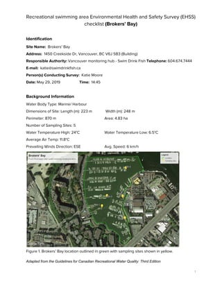
  • 1.   Recreational swimming area Environmental Health and Safety Survey (EHSS)  checklist ​(Brokers’ Bay) Identification  Site Name:​ Brokers’ Bay  Address: ​ 1450 Creekside Dr, Vancouver, BC V6J 5B3 (Building)  Responsible Authority: ​Vancouver monitoring hub - Swim Drink Fish ​Telephone: ​604.674.7444   E-mail:​ ​katie@swimdrinkfish.ca  Person(s) Conducting Survey:​ Katie Moore  Date:​ May 29, 2019 ​Time: ​ 14:45    Background Information  Water Body Type: Marine/ Harbour  Dimensions of Site: Length (m): 223 m  Width (m): 248 m   Perimeter: 870 m  Area: 4.83 ha  Number of Sampling Sites: 5   Water Temperature High: 24°C Water Temperature Low: 6.5°C  Average Air Temp: 11.8°C  Prevailing Winds Direction: ESE  Avg. Speed: 6 km/h    Figure 1. Brokers’ Bay location outlined in green with sampling sites shown in yellow.  Adapted from the Guidelines for Canadian Recreational Water Quality: Third Edition 1 
  • 2.   Figure 2. Monthly mean temperature and mean precipitation for 2018 from Vancouver Harbour  CS weather station (​Government of Canada​, 2019).    Figure 3: Yearly wind direction. Data collected from the False Creek Fuel station and published  on ​Windfinder.  Prevailing Winds Direction: ESE  Avg. Speed (km/h): 6  SWIM DRINK FISH | 2
  • 3. Prevailing Currents Direction: Tide dependent Avg. Speed (km/h): Tide dependent  Precipitation Data for 2018  Rainfall Total (mm) in 2018: 1721.3   24-h High (mm): 77.5 (December 13)       Figure 4. Total precipitation (mm) per month in 2018 from Vancouver Harbour CS weather station  (​Government of Canada​, 2019).    Surrounding Land Uses:   ● Urban ✓   ● Residential ✓   ● Commercial (specify): commercial fishery ✓   ● Harbour ✓   ● Recreational ✓ Brokers’ Bay and the surrounding land is located on the traditional unceded territories of the  Coast Salish People including the Tsleil-Waututh (səl̓ilw̓ətaʔɬ), Squamish (Sḵwx̱wú7mesh  Úxwumixw) and Musqueam (xʷməθkʷəy̓əm) Nations.    SWIM DRINK FISH | 3
  • 4. False Creek was historically a much larger tidal flat area up until 1913 when the eastern half of the  flats were filled in to make Vancouver’s main railway station, now known as Pacific Central. After  the railway station was built and up until the 1950's, False Creek was the industrial heartland of  Vancouver. The land surrounding False Creek has now been highly urbanized with commercial  and residential buildings. Vancouver Coastal Health has classified False Creek as not suitable for  swimming (primary contact with water) and advises only secondary contact recreation activities  “that result in regular wetting of limbs, but swallowing of water is unusual” be permitted in False  Creek (ie. canoeing, kayaking, sailing, fishing) (​VCH​, 2019).     Granville Island was built for industrial purposes in the early 1900s, it used to be called Industrial  Island. Several factories were established mainly serving the mining and forestry industries.  During World War II, Wright’s Canadian Ropes on the island was Canada’s biggest manufacturer  of heavy-duty wire rope. The government later invested millions to make the island a recreational  area of the city (1970s). Until then, Granville Island did not have any green space. The Island’s  public market was established in 1979.     Brokers’ Bay is located at the South Western side of Granville Island between Foreshore walk  and the Fisherman’s Wharf, owned by False Creek Harbour Authority.   The commercial buildings and spaces nearby include the following:  ● False Creek Harbour Authority (commercial fishing boats and pleasure crafts)  ● Maritime Market & Marina Ltd  ● Granville Island Public Market  ● Boat Yard  ● Tony’s Fish and Oyster Cafe   ● Vancouver Theatre Sport League   ● Fraser Yacht Sales   ● Blue Pacific Yacht Charters   ● Cooper Boating   ● Bluewater Rigging   ● Wilson Boating   ● Vancouver Water Adventures   ● Ecomarine Paddlesport Center   ● Specialty Yacht Sales   ● Skookum Yacht Services   ● Bridges Restaurant   ● Go Fish Restaurant   ● Seawall with biking and walking paths  ● Vancouver Fish Company  SWIM DRINK FISH | 4
  • 5. A. Microbiological Hazards Assessment  Potential Sources of Faecal Contamination  ● Stagnant water ✓  ● Municipal Sewage Discharges ✓    ● Stormwater Drains/Discharges ✓  ● Combined Sewer Overflows (CSOs) ✓  ● Other Discharges of Faecal Wastes (List): ✓  ○ Boat discharges    Stormwater Runoff from:  ● Runoff from surrounding area i.e., roads, walkways, and other impermeable  surfaces ​✓ ● Boat yards ​ ✓  Other Environmental Sources:   Environmental Sources  Category (None, Low, Med, High)  Birds (e.g., gulls, ducks, geese, other)   Medium  Other wild animals: Fish/ seals/cetaceans  High  Pets   Low  Swimmers  None  Table 1. Summary table of wildlife for Brokers’ Bay 2018 sampling season (July 19-  December 27). Wildlife Count Cormorant 17 Seagull 67 Duck 15 Crow 22 Seal 9 Swallow 2 SWIM DRINK FISH | 5
  • 6. Heron 2 Dead Cormorant 1 Table 2. ​Summary table of people recreating for Brokers’ Bay 2018 sampling season  (July 19- December 27). People Count Zodiak 3 Rowing Boat 6 Kayak 5 Standup Paddle Board 8 Motor Boats 2 Sea-doo 2 Paddler 5   Items for Consideration during the Microbiological Hazards Risk Assessment:  ● Proximity of potential contamination sources to the swimming area.   The potential area where individuals might swim or fall in the water is relatively close to the CSO  located on the north side of Granville Island, next to the ferry dock location. It is also in close  proximity to boats anchored in the marina.     ● Potential for contamination sources to have an impact on the swimming area (including an  indication of their risk priority: Low, Medium, High).   Due to the presence of a CSO into this part of False Creek and all the boats anchored in the  marina, there is a ​high​ potential for the swimming area to be impacted by contamination sources.     ● Evaluation of water quality according to historical microbiological data (e.g., frequency of  exceedances of the guideline values for the recommended indicators of faecal  contamination [e.g., continuous/periodic/sporadic]).   According the sampling completed by Fraser Riverkeeper from 24 sample events (July 13-  December 27th) in 2018, Brokers’ Bay passed the Canadian Guidelines for Recreational Water  Quality 52% of the time and failed the standards 40% of the time.      SWIM DRINK FISH | 6
  • 7. Table 3. Fraser Riverkeeper 2018 sampling results for Brokers’ Bay taken from Swim Guide.  Year  # of Sample Events  Pass  Fail  2018  25  92%  8%    ● Discharges: Assessment of such factors as volume, flow rate, treatment type, applicable  indicator standards, periodicity (continuous, sporadic) and predictability.   The discharges into the Brokers Bay site could include untreated sewage from the CSO located  on the north side of Granville Island, along with other wastewater, and stormwater runoff.  According to the Effluent Regulatory Reporting Information System (ERRIS) and the Wastewater  Systems Effluent Regulations (WSER), 75,600 m3 of raw effluent were deposited via the Granville  CSO point in 2017 (45,200 m3 in 2016 and 99,500 m3 in 2015).    ● Effects of rainfall: Levels triggering contamination events and typical event duration.   CSOs in Vancouver flow more frequently in the winter months (October through April) when there  are significant storm events that result in higher risk of contamination to the water body.     ● Assessment of swimming area circulation: Effect of onshore winds, tides, currents, flow  patterns in transporting faecal contamination to and entrapping it within the swimming  area.   Brokers’ Bay is a sheltered area, with slow moving surface currents. Entrapping of faecal  contamination is at a high risk considering the area is densely populated with boats and the flow  is tide dependent.    ● Animals and birds: Assessment of their types, numbers and dropping​s.   Environmental surveys from 2018 documented 73 animals in total: mostly birds but also a few  seals. Due to insufficient information concerning the link between wildlife and water  contamination, the impact the birds and animals have on the water quality is unknown.     ● Impact of swimmers on water quality—numbers, ages.   No swimmers have been observed in the water. However, Brokers’ Bay is the launching area of  several water recreational rentals companies. 19 kayaks, SUP etc. leaving or returning from the  Bay were observed on Thursday mornings from July to December 2018.     ● Assessment of potential barriers: Barrier types and points at which they may be applied to  reduce the impact of the contamination source and/or swimmer exposure.  The presence of the Granville Island’s CSO as well as possible boat discharges in the marina are  to be considered as a potential source of contamination. Solutions include the implementation of  decentralized urban best management practices (BMP) for stormwater control which include:  ● Infiltration practices;  ● Pocket wetlands;  SWIM DRINK FISH | 7
  • 8. ● Porous pavement;  ● Rain barrels/cisterns;  ● Rain gardens;  ● Soil amendments;  ● Tree box filters;  ● Vegetated (green) roofs;   ● Vegetated swales;  ● Pump out stations   This helps reduce the stormwater volume and improves stormwater quality, thus reducing the  likelihood of CSOs releasing into the site and also improving the water quality of the potential  discharges.      B. Chemical Hazards:  As is the rest of False Creek, Brokers’ Bay was formerly an industrial hub. The potential exists for  chemical contamination from historic industrial waste that might remain in the area. However,  more research and sediments testing are required to confirm this factor. Potential Sources of Chemical Contamination: Commercial/Industrial Discharges: high potential  ● Marinas ✓   ● Motorized Watercraft ✓     Stormwater Runoff From:   ● Urban Areas ✓   ● Areas subject to Pesticide Application: yes  ● Areas subject to Fertilizer Application: yes  Items for Consideration during the Chemical Hazards Risk Assessment:   ● Proximity of potential contamination sources to the bathing area.  Motorized and non motorized vessels dock in the bay. Even though this is not a bathing area,  there are several paddling and kayaking companies on Granville Island offering rentals, most  notably Ecomarine and Vancouver Adventure Sports. This makes Brokers’ Bay a very popular site  for recreational water activities.     ● Potential for contamination sources to have an impact on the swimming area  (including an indication of their risk priority: Low, Medium, High).  The potential for contamination sources to have an impact on the swimming area is ​high​.     ● Discharges: Assessment of such factors as volume, flow rate, treatment type,  periodicity (continuous, sporadic) and predictability.   The impacts that the motorized boats have are unknown. No research exists assessing factors  such as volume, flow rate, treatment type, periodicity, and predictability.     SWIM DRINK FISH | 8
  • 9. ● Effects of rainfall: Levels triggering contamination events and typical event duration.   Due to Brokers Bay’s proximity to parking lots on Granville Island, and roadways, the impacts of  rainfall and the subsequent runoff is high. The levels required to trigger a contamination event is  unknown, as well as the typical event duration. Swimmers are advised to remain out of the water  for 24hrs after a rainfall event.     ● Assessment of swimming area circulation: Effect of onshore winds, tides, currents,  flow patterns in potentially transporting chemical contamination to and entrapping it  within the swimming area.   Brokers’ Bay is a sheltered area, with slow moving surface currents. Entrapping of faecal  contamination is at a high risk considering the area is densely populated with boats and the flow  is tide dependent.    False Creek is saltwater and thus influenced by marine tides. Vancouver experiences mixed  semidiurnal tides which means there are two high and two low tides with different sizes each  lunar day. The tides are also affected by Spring tides which occur about twice a month at new  moon and full moon which are higher and stronger tides and neap tides during first and last  quarter of the moon which are lower and weaker tides. The flushing rate of the tides in False  Creek is not only affected by daily high and low tides but the cycle of the tides in the monthly  lunar cycle.    ● Motorized watercraft: Assessment of their types and numbers.  The two marinas located in Brokers’ Bay, the False Creek Harbour Authority and Maritime Market  & Marina Ltd, both hold a large variety of both motorized and non-motorized boats. Fisherman’s  Wharf also houses multiple commercial fishing vessels. Exact numbers are unknown.    ● Assessment of potential barriers: Barrier types and points at which they may be  applied to reduce impact of the contamination source and/or swimmer exposure.   Refer to barriers and techniques mentioned in the microbiological hazards assessment section.  C. Other Biological Hazards   Other Biological Hazards Known to Affect the Recreational Water Area (Presence may be  continuous, seasonal or sporadic.) ● Cyanobacterial Blooms - unknown   ● Schistosomes (Swimmer’s Itch) unknown  ● Large Numbers of Aquatic Plants: limited  Items for Consideration during the Biological Hazards Risk Assessment:  ● Seasonal nature of the hazard: continuous, annual, sporadic.  Additional research is required to assess the seasonal nature of biological hazards.    ● Presence of contributing factors (as applicable): water conditions, local geography,  temperatures, nutrient levels, presence of appropriate host species.  SWIM DRINK FISH | 9
  • 10. Additional research is required to assess the presence of contributing factors of biological  hazards in the site.     ● Assessment of potential barriers to control hazard and/or reduce human exposure in  areas/during times of increased risk.  Until the biological hazards are assessed, an assessment of potential barriers to control the  hazard is not feasible.   D. Physical Hazards and Aesthetic Considerations Subsurface Hazards:   Steep Slopes or Dropoffs ✓   Depths greater than 4.5 m ✓     Water Conditions:   Strong Currents or Rip Tides - no   Undertows - no  Other: (Select from None Low Med High)   Litter on Beach ✓ Medium  Floating Debris ✓ Medium  Broken Glass or Other Sharp Objects ✓  Low  Medical Wastes ✓  None  Sewage waste ✓ None  Seaweed/Algae on Beach ✓  Medium   Microplastics ✓ Medium potential    SWIM DRINK FISH | 10
  • 11.   Figure 5. Litter counted during the sampling events from July 19 to December 27, 2018 at  Brokers’ Bay.     Vehicles Permitted on Beach or Near Bathing Area:   Automobiles - ✓  Boats/Watercraft ✓ Specify: Cruise ships, restaurant boats, party boats, sea-doos, personal boats,  commercial boats, canoes, kayaks.     Items for Consideration during the Resulting Risk Assessment:   ● Assessment of the physical characteristics of the beach and their potential impacts on  safe enjoyable use of the area. Includes evaluation of physical layout (geography,  topography), composition of shoreline and bottom material, influence of existing  structures.   The shoreline area is a paved area. The water level at Brokers’ Bay is 1 to 2 m below the  shoreline (depending on the tide). There is an access to the water via the dock. The depth of the  water is > 5 m, and the bottom material is likely accumulated sediments, aquatic plants, and  possible contaminants from the industrial era.    ● Assessment of potential risks posed by specific hazards/factors in causing injury or  illness or otherwise interfering with the enjoyable use of the area.   The drop off from the shoreline into the water at low tide can represent potential risks to the  public using the space. There is no beach for people to access the water easily.     SWIM DRINK FISH | 11
  • 12. ● Shoreline and water free from obstructions and of sufficient clarity to permit viewing of  persons who may be in distress.   The shorelines and water are obstructed in all parts of the site because of the dense presence of  boats, easily hiding a person in distress.      ● Assessment of the nature and origin of litter and floating debris.   The litter at Brokers’ Bay most likely comes from the streets and the variety restaurants located  around the public market. During the summer months, it is common to see people eating outside  by the water, on the picnic tables or on the waterfront benches. A large quantity of the litter  observed was food related.     ● Applicable physical and aesthetic parameters (pH, temperature, turbidity, colour,  clarity, litter) in agreement with recommendations given in the Guidelines for Canadian  Recreational Water Quality.   Physical parameters was not consistently recorded during the 2018 sampling events.  Temperature and water clarity were recorded consistently using a thermometer and Secchi disk,  however the other parameters are based on subjective observations. Tidal data was not  collected, which would have an effect the Secchi depth measurements.     Table 4. Physical parameters ​for Brokers’ Bay 2018 sampling season (July 19- December  27).  Parameter  Observations  Temperature (°C)  Min: 6.5 Max: 24 Average: 13.8  Turbidity   Unknown  Colour  Average colour: dark green   Clarity (m)  Average visibility observed with the Secchi disk: 3.4 m  Odour  Sometimes sewage or fishy odour in the summertime, at low tide   Litter   Medium presence      ● Assessment of potential barriers to control hazard and/or reduce human exposure in  areas/during times of increased risk.   Refer to barriers and techniques mentioned in the microbiological hazards assessment section.    E. Facilities and Safety Provisions  Facilities​:  Toilets #: 4 (West side of Granville Island); 4 (Fisherman’s Wharf)   Showers #: 2 (Fisherman’s Wharf)  SWIM DRINK FISH | 12
  • 13. Drinking Water Fountains #: 2 (West side of Granville Island)  Litter Bins #: 4  Access for Persons with Disabilities: yes    Safety Provisions:   Lifeguard Stations #:  0 Lifesaving Equipment #: 0  Emergency Telephone #: 0 First Aid Stations #: 0    Signs/Communication Materials:   Beach Posting/Suitability for Swimming - no   Emergency Contact Information - Yes (Fisherman’s Wharf)    Formal Procedures or Reporting Mechanisms in Place to Deal with:   Municipal or Industrial Spills/Discharges/Treatment Bypasses - yes (Fisherman’s Wharf)  Waterborne Disease Outbreaks - no   Swimmer Injuries - no    Items for Consideration during the Resulting Risk Assessment:  ● Assessment of the adequacy of facilities and safety provisions.  The facilities in the area are limited, as there is no official place to swim.     ● Evaluation of signs and other materials for public communication: Message clear and  concise, signs placed in locations highly visible to the public.  No signs are posted pertaining to swimming advisories.  SWIM DRINK FISH | 13