2013 Poster Session, Geospatial Modeling of Mountain Pine Beetle Mortality by Aaron Sidder

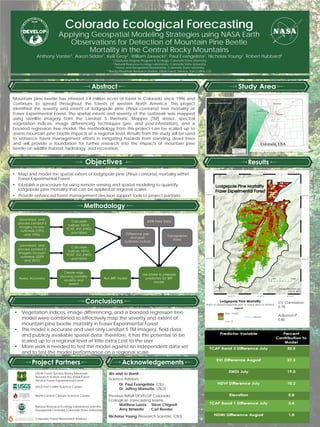
Mountain pine beetle (Dendroctonus ponderosae) has infested 3.4 million acres of forest in Colorado since 1996 and continues to spread throughout the forests of western North America. This project identified the severity and extent of lodgepole pine (Pinus contorta) tree mortality at Fraser Experimental Forest (FEF). We mapped the spatial extent and severity of the outbreak using the Software for Assisted Habitat Modeling (SAHM) and a boosted regression tree model. The model combined satellite imagery from the Landsat 5 TM sensor, a variety of spectral vegetation indices, differenced satellite images (pre- and post-infestation), and field data collected at FEF. The results yielded a continuous mortality map showing the ratio of dead lodgepole pine to the basal area of all trees. The model accuracy was tested in R and had a cross validation (CV) correlation of 0.782 and an adjusted r-squared of 0.8072. The methodology from this project can be scaled up to assess mountain pine beetle impacts at a regional level. Results from this study will be used to enhance forest management efforts in mitigating hazards from standing dead trees and will provide a foundation for further research into the impacts of mountain pine beetle on wildlife habitat, hydrology, and recreation.
Recommended

Recommended
More Related Content
What's hot
What's hot (19)
Viewers also liked
Viewers also liked (20)
Similar to 2013 Poster Session, Geospatial Modeling of Mountain Pine Beetle Mortality by Aaron Sidder
Similar to 2013 Poster Session, Geospatial Modeling of Mountain Pine Beetle Mortality by Aaron Sidder (20)
More from GIS in the Rockies
More from GIS in the Rockies (20)
2013 Poster Session, Geospatial Modeling of Mountain Pine Beetle Mortality by Aaron Sidder
- 1. Colorado Ecological Forecasting Applying Geospatial Modeling Strategies using NASA Earth Observations for Detection of Mountain Pine Beetle Mortality in the Central Rocky Mountains Mountain pine beetle has infested 3.4 million acres of forest in Colorado since 1996 and continues to spread throughout the forests of western North America. This project identified the severity and extent of lodgepole pine (Pinus contorta) tree mortality at Fraser Experimental Forest. The spatial extent and severity of the outbreak was mapped using satellite imagery from the Landsat 5 Thematic Mapper (TM) sensor, spectral vegetation indices, image differencing techniques (pre- and post-infestation), and a boosted regression tree model. The methodology from this project can be scaled up to assess mountain pine beetle impacts at a regional level. Results from this study will be used to enhance forest management efforts in mitigating hazards from standing dead trees and will provide a foundation for further research into the impacts of mountain pine beetle on wildlife habitat, hydrology, and recreation. We wish to thank… Science Advisors Dr. Paul Evangelista, CSU Dr. Jeffrey Morisette, USGS Previous NASA DEVELOP Colorado Ecological Forecasting teams: Matthew Luizza Steve Chignell Amy Birtwistle Carl Reeder Nicholas Young (Research Scientist, CSU) Natural Resource Ecology Laboratory and the Geospatial Centroid, Colorado State University USDA Forest Service Rocky Mountain Research Station and the USDA Forest Service Fraser Experimental Forest USGS Fort Collins Science Center North Central Climate Science Center CV Correlation: 0.78 Adjusted r2 : 0.80 Colorado Forest Restoration Institute • Map and model the spatial extent of lodgepole pine (Pinus contorta) mortality within Fraser Experimental Forest • Establish a procedure for using remote sensing and spatial modeling to quantify lodgepole pine mortality that can be applied at regional scales • Provide enhanced forest management decision support tools to project partners • Vegetation indices, image differencing, and a boosted regression tree model were combined to effectively map the severity and extent of mountain pine beetle mortality in Fraser Experimental Forest • This model is accurate and uses only Landsat 5 TM imagery, field data, and publicly available spatial data; therefore, it has the potential to be scaled up to a regional level at little extra cost to the user • More work is needed to test the model against an independent data set and to test the model performance on a regional scale Anthony Vorster1, Aaron Sidder1, Kelli Groy2, William Zawacki3, Paul Evangelista2, Nicholas Young2, Robert Hubbard4 1 Graduate Degree Program in Ecology, Colorado State University 2 Natural Resource Ecology Laboratory, Colorado State University 3 Forest and Rangeland Stewardship, Colorado State University 4 Rocky Mountain Research Station, USDA Forest Service, Fort Collins, CO