1. Impacts of the Proximity of Farmland on the Hillsborough River
Erin Plachy
References
Cooke, G. D., Welch, E. B., & Jones, J. R. (2011). Eutrophication of Tenkiller Reservoir, Oklahoma, from nonpoint agricultural runoff. Lake and Reservoir Management, 27(3), 256-270.
Monteagudo, L., Moreno, J. L., & Picazo, F. (2012). River eutrophication: Irrigated vs. non-irrigated agriculture through different spatial scales. Water Research, 46, 2759-2771.
William, S., Herr, J., Litton, G., Brunell, M., Borglin, S., Hanlon, J., Chen, C., Graham, J., Remie, B., Dahlgren, R., Kendall, C., Brown, R., Quinn, N. (2009). Investigation of river eutrophication as a part of a low dissolved oxygen total maximum daily load implementation. Water Science & Technology, 59(1), 10-14.
Data obtained from the Florida Geographic Data Library. http://www.fgdl.org/metadataexplorer/explorer.jsp
Images: http://www.dashofeast.com/wp-content/uploads/2011/05/Washington_Farms_Strawberries_3.jpg, http://www.dimeofarms.com/1008977_601213379902786_547589363_o.jpg , http://www.wcvb.com/image/view/-/18127374/highRes/1/-/xyt5dkz/-/Blueberries-Strawberries.jpg
Abstract/Introduction
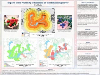
ArcGIS was used to map the proximity of farmland
to the Hillsborough River in Florida and to examine
the effects of the proximity on the river. Lots of
farmland and pastureland were located within 9
miles of the river. Several factors were examined and
high levels of chlorophyll a, low dissolved oxygen,
fecal coliform, and mercury in fish tissue were
present.
Arable land is often found near water sources for
easy access to water for irrigation. Fertilizers and
pesticides are commonly used to increase the yield
of the crops. The excess of these chemicals tend to
runoff into nearby water sources, causing
eutrophication and negatively affecting the aquatic
life. In pastureland, livestock waste can runoff into
these same sources with similar results. Agricultural
land located over 6 miles away can still reduce the
health of the waterbody.
Methods
ArcGIS was used to map the proximity of farmland
to the Hillsborough River in Florida. Buffers
distanced at 3, 6, and 9 miles were used to visually
represent the proximity of the cropland and
pastureland to the river. The impairments found in
the water were mapped to show the potential
impacts of nearby farmland.
Results
A significant amount of farmland is located within
the 3, 6, and 9 mile buffers of the river. A
combination of chlorophyll a and/or low dissolved
oxygen was found in all of the areas studied. Other
impairments found were fecal coliform, mercury in
fish tissue, and un-ionized ammonia.
Conclusion
The farmland located within the 3 mile buffer likely
contributes to most of the impairments found in the
river. The high chlorophyll a and low dissolved
oxygen is due to algal blooms and eutrophication
from runoff from the nearby farms. Fecal coliform
can be traced to livestock waste and the un-ionized
ammonia is likely from fertilizer use. The mercury’s
source is probably from mines in the area. Overall,
proximity of farmland appears to be a factor in the
impairment of the Hillsborough River.
Strawberry farms are very common in
areas around the Hillsborough River.
Blueberries are also a popular crop
grown around the Hillsborough River.