1. Urban PlanningTools for
Climate Change Mitigation
Pat r i c k M . Co n d o n , D u n c a n C av e n s , a n d N i co l e M i l l e r
Policy Focus Report • Lincoln Institute of Land Policy
3. c o n d o n , C av e n s & M i l l e r ● u r b a n p l a n n i n g t o o l s 1
...................
Connected
Crow-Fly Buffer
Sample Household
Network Buffer
Single Family Residential
Multi Family Residential
Commercial
Office
Industrial
Greenspace/Recreational
Parking
Unknown
Institutional
Contents
2 Executive Summary
4 Chapter 1: The Relationship Between Climate Change
and Urban Planning
5 The Challenge of Climate Change
6 The Relevance of Urban Form
8 Tools and Frameworks for Urban Planners and Policy Makers
10 Chapter 2: Characteristics of Modeling and Support Tools
10 Scope
11 Methodology
12 Scale
13 Support for Policy Making
16 Chapter 3: Existing Tools to Assess GHG Emissions
20 Chapter 4: Case Studies: Applications of Selected Tools in Planning Projects
20 INDEX: Designing a Cool Spot Neighborhood
27 I-PLACE3
S: Initiating Health and Climate Enhancements
31 Envision Tomorrow: Using Prototype Buildings and Scenario Modeling
to Measure Carbon Footprint
37 Development Pattern Approach: Measuring GHG Impacts of
Land Use Decisions
43 Chapter 5: Conclusions and Recommendations
46 References and Web Resources
47 About the Authors and Contributors
48 Acknowledgments
4. 2 p o l i c y f o c u s r e p o r t ● L i n c o l n I n s t i t u t e o f L a n d P o l i c y
...................
Executive Summary
T
he scale of intervention required
to reduce and adapt to the effects
of climate change will require ac-
tion at all levels of government and
society. International accords to limit overall
carbon emissions will involve national gov-
ernments. Setting carbon emission targets
and standards by industry or sector, or fuel
efficiency standards for vehicles, tradition-
ally falls within the purview of federal and
state or provincial governments.
Some state governments are beginning
to require local governments to meet green-
house gas (GHG) reduction targets in rela-
tively short periods of time. However, it is
at the local level that most decisions about
urban form are made—by public officials,
practitioners, and citizens in cities, counties,
metropolitan organizations, and special ser-
vice districts. Yet urban planners and local
decision makers generally lack the tools and
means needed to make informed choices
about the climate change implications of
local growth and redevelopment decisions,
or to measure their effects.
Policy makers and regulators at all urban
scales, as well as their political constituents
and stakeholders, need decision support
tools that illustrate the GHG implications of
urban form so they can make sound, locally
relevant land use decisions. While a wide
spectrum of tools currently exists, few have
5. c o n d o n , C av e n s & M i l l e r ● u r b a n p l a n n i n g t o o l s 3
...................
the capacity to work simultaneously at both
the regional and local scale, or to capture
the multiple consequences of regulatory
decisions. They generally lack the capacity
to model the land use–GHG relationship in
a way that easily and in real time informs
the policy process.
This report focuses on the present state
of tools to model and evaluate the relative
climate change benefits of alternative devel-
opment approaches in cities, ranging from
the project to the neighborhood to the metro-
politan scale. Four case studies illustrate how
selected tools are already being used in the
urban planning and development process
in the United States and Canada.
While no one tool can yet address all
of the desiderata identified by officials and
experts, the potential to build on the strengths
of existing tools is promising. Continued tool
development will serve to enhance connec-
tions among various tools, create new methods
of evaluating urban form and GHG emis-
sions, and establish test cases through which
new tools can be applied and refined.
An ideal tool or integrated suite of tools
should have the following characteristics.
• Comprehensive: able to capture the
GHG contributions of all relevant sectors,
including buildings and transportation,
and support the consideration of addi-
tional criteria related to the economy
and livability.
• Three-dimensional: grounded in
the physical realities of the urban spaces
they seek to model, and able to provide
vivid and accurate descriptions of the
consequences of future community design.
• Multi-scalar: able to connect top-
down (from regional to block scale) with
bottom-up analysis and respond to the
interactions between incremental site-
scale decisions and regional and higher-
level decisions on GHG emissions.
• Policy-relevant: supportive of the
way policy is made and implemented,
in terms that are direct and useful to
decision makers.
• Iterative: capable of testing alternative
scenarios in real time, including within
multi-stakeholder decision processes
and planning charrette environments,
to produce results that can be evaluated
rapidly and incorporated into plan
modifications for improved outcomes.
• Additive: able to build on and link to
existing models and related applications.
• Accessible: intelligible to a wide
range of stakeholders, using a common
language and interface with transparent
outputs.
• Affordable: relatively inexpensive to
acquire and easy to use by staff and
consultants to obtain useful results.
To produce such a tool or suite of tools
may appear daunting, but the need is great
to support effective planning and regulatory
decisions, and to set and adjust policy. We
are poised to make planning and policy de-
cisions at the international, national, state,
provincial, regional, and local levels that
will have potentially enormous consequences.
This report can guide public officials and
proponents of development projects in mak-
ing better informed decisions with respect to
climate change impacts, and can help tool
developers and modelers identify critical
needs as they design the next generation
of planning support tools.
6. 4 p o l i c y f o c u s r e p o r t ● L i n c o l n I n s t i t u t e o f L a n d P o l i c y
...................
C h a p t e r 1
The Relationship Between Climate
Change and Urban Planning
Unprecedented human intervention will
be required in the coming decades to reduce
the extent of climate change and thereby
avoid its worst potential consequences
(referred to as mitigation), or make changes
to accommodate those effects that are un-
avoidable (adaptation). Much of the mitiga-
tion policy discussion to date has centered
on reducing greenhouse gas (GHG) emis-
sions through fuel substitution and fuel effi-
ciency for vehicles and on energy efficiency
for buildings and industries.
At the same time, there is a growing
acknowledgement by scientists and policy
analysts that a substantial part of the global
warming challenge may be met through the
design and development of cities. The form
and function of human settlements can either
C
limate change is among the most
important issues of our time.
Rising global temperatures, largely
the product of human activity,
are likely to have severe—and potentially
catastrophic—effects on both the earth’s
natural systems and human society. Sea
level rise and dramatic changes in weather
patterns, predicted as a consequence of
sustained global warming, could accelerate
the disruption of economic systems, disloca-
tion of coastal communities and port facili-
ties, shortages of food and water supplies,
increases in disease, additional health and
safety risks from natural hazards, and large-
scale population migration. Secondary
effects may include the potential for civil
unrest and war.
Los Angeles,
California
7. c o n d o n , C av e n s & M i l l e r ● u r b a n p l a n n i n g t o o l s 5
...................
reduce or increase the demand for energy,
and can also influence how energy is pro-
duced, distributed, and used. As world pop-
ulation and economic activity increase,
urban form factors may play as important
a role as reduced fuel use in diminishing
the extent of avoidable climate change.
The scale of intervention required to
reduce and adapt to the effects of climate
change will require action at all levels of
government and society. International accords
to limit overall carbon emissions will involve
national governments. Setting carbon emis-
sion targets and standards by industry or
sector, or fuel efficiency standards for vehi-
cles, falls within the traditional purview of
federal and state or provincial governments.
Some state governments are beginning
to require local governments to meet GHG
reduction targets in relatively short periods
of time. A 2008 Washington State Senate
Bill on Climate Action mandates emission
reporting and requires GHG reductions of
25 percent below 1990 levels by 2035 and
50 percent by 2050 (State of Washington
2008). Similarly, the California Global Warm-
ing Emissions Cap sets a statewide GHG
cap for 2020 based on 1990 emissions levels
(State of California 2006), while the B.C.
Greenhouse Gas Reduction Targets Act
requires emissions reductions of at least
33 percent below 2007 levels by 2020,
and 80 percent below 2007 levels by 2050
(Province of British Columbia 2007).
Despite these state-level efforts, most deci-
sions about urban form are made at the lo-
cal level—by public officials, practitioners,
and citizens in cities, counties, metropolitan
organizations, and special service districts.
Yet urban planners and local decision mak-
ers generally lack the tools and means need-
ed to make informed choices about the cli-
mate change implications of local growth
and redevelopment decisions, or to measure
the effects of those decisions.
T he challe n ge o f
C limate C hange
Over the past 60 years, average annual
global temperatures have been rising to
levels unprecedented in the past 100,000
years. Scientists believe this is due primarily
to human activity, and that the burning of
carbon fuels has been the principal contrib-
utor to the overproduction of GHGs that
create a blanket in the earth’s atmosphere,
trapping the warmth of the sun. Because
greenhouse gases accumulate rather than
dissipate over time, the earth’s atmospheric
temperature has been rising and will rise
further, likely producing two primary phe-
nomena over the next several decades that
could have enormous consequences for
natural systems and human settlements.
1. The melting of land-based ice masses
could result in long-term sea level rise,
potentially submerging vast amounts
of coastal land.
2. Changes in global and local weather
patterns and dynamics could result in
substantially higher incidences of flood-
ing, drought, wildfires, and landslides.
8. 6 p o l i c y f o c u s r e p o r t ● L i n c o l n I n s t i t u t e o f L a n d P o l i c y
...................
Most scientists now predict that tempera-
tures will rise even faster over the next 40
years than recently, due in part to the accu-
mulation of GHGs in the earth’s atmosphere,
and in part to rapidly growing populations
and economies in Asia and South America.
They believe that some amount of global
temperature rise is now inevitable (on the
order of 1 to 2 degrees Celsius by 2050)
and will result in increases in sea level and
changes in weather patterns with concomi-
tant impacts on food supply, natural hazards,
and economic activity.
This phenomenon will require aggres-
sive adaptation strategies to address the un-
avoidable results of climate change. Among
the measures to be considered are limiting
development in flood-prone areas, enhanc-
ing flood control systems, ramping up water
and soil conservation measures, rationing
water, and improving inoculation rates for
infectious diseases.
Further global climate change (another
2 degrees Celsius or more) and its most
catastrophic effects are avoidable through
aggressive mitigation strategies. In the last
three years a scientific and policy consensus
has emerged around an overall objective for
mitigation: to reduce annual GHG produc-
tion to a level that is 80 percent below 1990
levels by the year 2050 (roughly equivalent
to 1955 U.S. levels). This objective is now
endorsed by a number of states in the United
States, and serves as the benchmark for
several new regulatory schemes.
Mitigation actions generally fall into two
categories: altering the supply source of en-
ergy, and reducing the demand for energy.
Since changing the supply source—shifting
from carbon-based to alternative fuels and
energy sources—will take decades, even un-
der aggressive carbon taxation scenarios,
strategies to reduce demand are extremely
important. Increasing the fuel efficiency of
vehicles and machinery and the energy effi-
ciency of buildings are two paths to reduc-
ing demand, but more profound measures
involve shifts in societal behavior and settle-
ment patterns.
T he R ele vance o f
Urba n Fo rm
Some analysis indicates that planning and
urban design measures can substantially
reduce the number and distance of vehicle
trips by organizing human activity in com-
pact communities with a range of housing
types, providing reliable transit to and from
employment, and placing services within
easy walking distance of home. For example,
Ewing et al. (2008) found that miles driven
are reduced by between 20 and 40 percent
in compact urban developments compared
to miles driven in the auto-dependent
suburbs that have predominated in North
America over the last 60 years.
Transportation activity of all forms con-
tributes about 33 percent of energy-related
GHG production in the United States, and
single-occupant automobile travel makes
up about half of that activity (figure 1). The
vast majority of vehicles now burn carbon
fuels and will continue to do so for some
time (even with aggressive fuel substitution
and efficiency measures), so strategies that
reduce travel by limiting suburban expan-
sion and encouraging more compact,
walkable, full-spectrum living and working
environments can potentially make a sig-
nificant contribution to overall climate
change mitigation.
A GHG reduction of up to 10 percent may
result from a change in land use approach
alone, and additional reductions will result
from employing other strategies such as
transit investment, fuel pricing, and parking
charges (Ewing et al. 2008). By one estimate,
approximately two-thirds of all development
in 2050 will be new or will have been rede-
veloped since 2007, suggesting that combined
9. c o n d o n , C av e n s & M i l l e r ● u r b a n p l a n n i n g t o o l s 7
...................
figure 1
Total Emissions of Fossil Fuel Carbon Dioxide, 2002
land use and transportation strategies could
be quite powerful in mitigating the increases
in GHGs (Nelson 2006).
The Portland (Oregon) metropolitan
area, for example, has deliberately contained
growth and provided transit options over the
past several decades to protect surrounding
farm and forest land. These policies have
reduced per capita vehicle trips by about 17
percent since 1990 and kept overall GHG
levels at about 1990 levels despite a 16 per-
cent growth in population (Metro Regional
Government 2000). Assuming the area main-
tains its commitment to “growing in, not
out,” population growth could actually pro-
duce further per capita carbon savings in
trip reduction by spawning a fuller array of
services and housing types in close proximity
and by making alternative transportation in-
vestments feasible in more locations through-
out the metropolitan landscape.
Additional carbon reductions could come
from exploiting other aspects of city making
and redevelopment. Using the critical mass
of buildings and activities at the district
scale, it is possible to develop practical and
efficient heating and cooling systems (district
energy systems). This approach shows great
promise in reducing the carbon footprint of
urban development, although the potential
costs and benefits of broad-scale application
have not yet been quantified sufficiently.
Other energy conservation benefits may
result from common-wall and vertical living
structures typical of multifamily urban
locations, as well as more efficient recycling
of solid waste.
While the impact of more compact land
use on building energy consumption has
been studied less extensively than its impacts
on transportation energy consumption,
several analyses have begun to explore this
The pattern
of higher carbon
dioxide emissions
relates closely
to highways and
urbanized areas.
Source: www.purdue.edu/eas/carbon/vulcan/plots.php
10. 8 p o l i c y f o c u s r e p o r t ● L i n c o l n I n s t i t u t e o f L a n d P o l i c y
...................
relationship. Norman et al. (2006), for ex-
ample, report that per capita energy con-
sumption and GHG emissions are 2 to 2.5
times higher in low-density developments
than in high-density areas.
Urban design also offers the potential
for cities to claim some of the attributes
now associated primarily with rural living,
including green infrastructure, such as natu-
ral systems that handle storm water and re-
duce heating loads, and localized food pro-
duction that reduces shipping, storage, and
packaging needs. These and other strategies
that exploit the nontransportation aspects
of urban form may contribute significantly
to overall GHG mitigation, but a more rig-
orous quantification of the potential bene-
fits is needed to augment the estimates al-
ready provided in the transportation sector.
Too ls and F ramewo rks
f or U rba n P la nn ers an d
Po licy M akers
Local governments have several ways of
influencing climate change mitigation. As
purchasers (and sometimes producers) of
power, they can influence the conversion of
energy to noncarbon sources. They can also
influence resident and local business behav-
ior through education, tax, and fee policy,
and other economic incentives or disincen-
tives. However, the greatest influence of
local governments is evident in their decisions
on urban form, primarily through urban
planning and land use regulation.
Local planning guides both infrastructure
investment and development regulation, the
arenas where decisions can be made about
mixed-use, walkable neighborhoods, alter-
Portland, Oregon
11. c o n d o n , C av e n s & M i l l e r ● u r b a n p l a n n i n g t o o l s 9
...................
native transportation approaches and invest-
ments, district energy, green infrastructure,
urban farming and farmers markets, and a
host of other decisions that can either ad-
vance or hinder climate change mitigation.
Policy makers and regulators at all urban
scales, as well as their political constituents
and stakeholders, need decision support
tools that illustrate the GHG implications of
urban form so they can make sound, locally
relevant land use decisions. While a wide
spectrum of tools currently exists, few have
the capacity to work simultaneously at both
the regional and local scale, or to capture
the multiple consequences of regulatory deci-
sions. They generally lack the capacity to
model the land use–GHG relationship in a
way that easily and in real time informs the
policy process.
Four key factors could ultimately help
planners and local government officials in
these efforts.
1. Articulating the “big math”—what portion
of the 80 percent of 1990 GHG levels by
2050 should be attributed to urban form,
and how much (what ranges) might be
achieved by the major components of
urban form and other local strategies?
2. Documenting and examining the devel-
opment status of tools and models for
estimating and measuring the climate
change effects of alternative development
strategies and scenarios at the neighbor-
hood, city, and metropolitan level.
3. Defining ways to deepen and broaden
the menu of local approaches to climate
change mitigation within the urban form
arena and to access information about
experiences in other jurisdictions.
4. Examining possible governance structures
to make more effective climate change
policies and investments. Cities and spe-
cial service districts are either too small
or too narrowly focused to act alone and
be successful, yet most metropolitan areas
lack effective regional governments.
This report focuses on the second issue:
the present state of tools to model and
evaluate the relative climate change benefits
of alternative development approaches in
cities, ranging from the project to the neigh-
borhood to the metropolitan scale. It sum-
marizes the relationship between urban
form and climate change, particularly in
the mitigation arena, and presents four case
studies that illustrate how selected tools are
already being used in the urban planning
and development process.
12. 10 p o l i c y f o c u s r e p o r t ● L i n c o l n I n s t i t u t e o f L a n d P o l i c y
...................
C h a p t e r 2
Characteristics of Modeling
and Support Tools
E
xisting urban design modeling
tools and GHG-related decision
support tools can be categorized
according to four characteristics:
scope, methodology, scale, and support for
policy making. These categories help us
compare the capacity of available tools, un-
derstand how they might complement each
other, and identify gaps in information and
decision-making support processes.
Scope
Single-sector Emissions Sources
Existing decision support tools differ in how
many sectors of the urban fabric they can
measure in terms of emissions sources.
Many are designed to do a detailed job on
just one sector, such as the GHG conse-
quences of certain policy changes, techno-
logically based efficiency enhancements, or
changes in transportation mode splits. Tools
utilizing a single-sector approach provide
important quantitative baseline emissions
data and help track progress toward reduc-
tion targets, but this information is usually
not robust enough to guide a systems-based,
all-inclusive approach to assessing and im-
plementing low-carbon land use policies.
Multi-sector Emissions Sources
Tools that encompass multiple emissions
sources may simply quantify total emissions
from multiple sectors, such as buildings,
transportation, waste, and agriculture, or
Charrette in
North Vancouver,
British Columbia
13. c o n d o n , C av e n s & M i l l e r ● u r b a n p l a n n i n g t o o l s 11
...................
they may represent the more complex rela-
tionships among these sectors. Tools with
the capacity to go beyond this quantification
can reflect a spectrum of issues, such as
transportation demand, mode and mix, or
energy use in buildings resulting from the
shape or arrangement of the urban fabric.
These are precisely the kinds of issues
that planners need to understand and
address in their communities. Multi-sector
comparisons provide critical information
that allows decision makers to target emis-
sions sources strategically for the greatest
reduction potential. This type of analysis
comes with a cost, however, resulting in
greater complexity and reduced certainty
due to the interactions of many variables
remaining in play.
Methodology
Available GHG tools can also be organized
according to their methodological approaches:
spatial/nonspatial, top-down/bottom-up,
simulation/end-state, and observation-based/
process-based. It is also possible for a single
tool to employ more than one approach.
Spatial/Nonspatial Methodologies
Decision support tools that use a spatial
methodology model the relationships among
urban elements. This is important because
the physical organization of a city—the ar-
rangement of its elements in space—greatly
impacts its carbon footprint. For example,
the proximity of one’s residence to employ-
ment, transit, and commercial services, as
well as the road network configuration among
these destinations, directly affects transpor-
tation choice and travel patterns.
Spatial tools are particularly useful for
modeling the transportation impacts of dif-
ferent scenarios, and for analyzing building
performance (e.g., solar access, wind mitiga-
tion from surrounding buildings, and vegeta-
tion) and determining feasible locations for
community energy systems using minimum
density thresholds. A nonspatial methodol-
ogy presents data findings in numerical
format and does not take into account the
analysis of the physical arrangement of
an urban area. While nonspatial tools are
less data-intensive and quicker to prepare,
spatial methods are, at least in theory, more
effective in supporting local government
planning for reduced GHG emissions.
Another advantage of using a spatial
methodology is that it allows for visual
representations of results, often using GIS
technology and 3-D modeling software
that make it easier for lay persons to under-
stand the physical implications of alterna-
tive strategies on GHG production. Further-
more, spatial methodologies can provide
more compelling visual outputs, allowing
decision makers, stakeholders, and consti-
tuents to imagine and understand the on-
the-ground impacts of policy choices.
Top-down/Bottom-up Methodologies
Tools using top-down methodologies oper-
ate at a broad geographical scale, typically
designed to support development of plans at
the municipal or regional level. In contrast,
tools using a bottom-up approach focus anal-
ysis on local, site-level projects. However,
few tools effectively blend both approaches
to assess or provide information on GHG
emissions across scales.
Simulation/End-state Methodologies
The methods used by existing tools to model
future impacts on urban form can be catego-
rized as either simulation or end-state assess-
ments. Simulation methodologies begin with
two primary data inputs: current land use
conditions, and a set of specific rules or
parameters defining how present conditions
will develop over time, including behavioral
patterns, technologies, and government pol-
icies. The modeling tool combines these two
14. 12 p o l i c y f o c u s r e p o r t ● L i n c o l n I n s t i t u t e o f L a n d P o l i c y
...................
can establish general relationships between
two parameters without measuring the di-
rect relationships among individual compo-
nents. Process-based simulation methods
explicitly model the choices or interactions
of individual agents or components within
a described system.
One difficulty with observation approaches
is that they are generally unable to function
outside the range of typically observed phe-
nomena. A further pitfall is their assump-
tion that data can be extrapolated accurately
from one locale to another. For example, the
impact of increased street connectivity on
transportation-based GHG emissions in a
large, temperate metropolitan area may not
be the same as in a small, northern commu-
nity with a different climate, scale, and set
of cultural preferences.
Scale
GHG assessment tools are also categorized
according to the geographical scale or scales
at which they operate, including individual
buildings, parcels, blocks, neighborhoods,
municipalities, regions, and bioregions.
Most existing GHG tools operate at a single
scale, measure and model impacts and per-
formance of specific individual buildings,
or utilize future land use scenarios at the
regional level. Some tools offer a more
flexible framework applicable at a variety
of municipal and regional scales.
GHG emissions are influenced by deci-
sions made at all scales—from individual
projects at the site scale to infrastructure
projects at the regional scale (figure 2). For
example, community or master plans at the
municipal scale might include increased
density targets that could potentially impact
ridership on regional and local transit; in-
crease the viability of utilities at the neigh-
borhood or municipal scales; and increase
or reduce average energy requirements for
building heating and cooling at the parcel
sets of data to forecast and simulate the out-
come that would result over a given time period.
End-state assessment methodologies
start with data describing future land use
and behavioral patterns—in other words,
the desired scenario to be achieved at a spe-
cific point in time. Performance is assessed
using data provided in the scenario, and
the changes required to achieve the desired
end state can then be back-cast from ideal
future conditions.
Simulation tools have one key limitation:
they are often constrained by present-day
assumptions regarding technological capa-
bilities and behavioral proclivities that are
embedded, often unconsciously, in the data
used to forecast future scenarios. As a result,
the scenarios often fail to consider or reflect
technological advancements or broad beha-
vioral shifts resulting from evolving societal
preferences or the sensitivity of individuals
to price signals.
Simulation methods are also highly com-
plex and time consuming, often requiring
months to model future scenarios. Con-
versely, end-state assessment methods can be
much simpler and faster in providing appro-
priate levels of data, thus allowing policy
makers and other users to break free of cur-
rent assumptions and norms. At the same
time, they sometimes sacrifice grounding in
real-world cases and the resulting richness
of data that those cases often provide.
Observation-based/Process-based
Methodologies
Simulation methodologies can be further
broken down into observation-based and
process-based approaches. The key differ-
ence is in how the underlying models are
calibrated. Tools with an observation-based
simulation method use empirical data to
establish the parameters of the model, such
as the impact of density on the proportion
of nonvehicular trips. Statistical techniques
15. c o n d o n , C av e n s & M i l l e r ● u r b a n p l a n n i n g t o o l s 13
...................
scale. Due to these interconnections, tools
with capacity to operate fluidly across multi-
ple geographical scales are the most desirable
way to inform low-carbon land use planning
decisions at all scales, albeit the most concep-
tually and practically challenging (figure 3).
Support for Policy Ma king
Currently available GHG tools can also be
classified according to the specific stage or
stages of the policy-making cycle that they
support, inform, and influence. In a democ-
racy, particularly in the United States and
Canada where most physical planning deci-
sions are made at the local level by bodies
responsible to public opinion, the processes
of land use planning do not always fit neatly
into a linear policy-making cycle. Further-
more, it is now apparent that reducing GHG
emissions resulting from city design cannot
be addressed exclusively through technologi-
cal change, behavioral change, transporta-
tion policy, road configuration, building de-
sign, economic development strategy, or fair
housing policy alone; the solutions require
coordinated action in all of these realms.
The increasingly widespread use of
the design charrette in land use planning
illustrates one response to this complexity
(Kwartler and Longo 2008). A charrette is
an intensive design and policy formulation
event that brings together diverse stake-
holders to produce through collaborative
interaction a plan for a sustainable commu-
nity (Condon 2007). It typically follows a
multistage process.
• In-depth research on issues important
to the community to inform workshop
decision making;
• Two to four preliminary workshops to
identify community goals and objectives
and to set performance targets;
figure 2
Scales of Urban Form and Policy Instruments to Impact GHG Emissions
Scale Urban Form Common Policies
Scales
Building, parcel
Building codes, zoning
bylaws, development
guidelines
Block, neighborhood, district
Local area plans, concept
plans, community visions,
development guidelines
Municipality
Municipal development
plans, comprehensive plans
Region, bioregion, megaregion
Regional growth strategies,
regional visions, regional
transportation plans
Source:DesignCentreforSustainability,UniversityofBritishColumbia
16. 14 p o l i c y f o c u s r e p o r t ● L i n c o l n I n s t i t u t e o f L a n d P o l i c y
...................
• Collaborative design during the charrette
itself, including facilitated stakeholder
discussion and selection of strategies to
achieve performance targets combined
with designer-only sessions during which
discussion outputs are translated into
rough drawings;
• Production of final drawings and devel-
opment of the final public presentation
and subsequent report;
• Translating the final presentation into a
final concept plan that describes the ideas
and goals generated at the charrette; and
• Development of implementation plans
and technical documents such as design
guidelines that describe the concept plan
in regulatory terms.
The theory underpinning charrettes is that,
given the complexity of sustainability factors,
there is no possibility for linear, single-issue
processes to manage them. The alternative
is synthetic, holistic, and inclusive integra-
tion of all issues that pertain to real-world
problems of city design, in a collaborative
and interdisciplinary setting (Condon 2007).
Successful charrettes and other multiparty
roundtable processes take advantage of all
the information and decision support tools
available. The challenge is to integrate the
information and tools in a form that fluidly
intersects the decision-making discourse.
The following five-step policy cycle model
accurately reflects the way that collabora-
tively produced sustainable community de-
sign decisions are made, and integrates the
existing tools into the stages to which they
are best suited (Hessing et al. 2005).
1. Information gathering. Research and assem-
bly of data helps to describe past and
present conditions and project the im-
pacts of various land use decisions.
2. Interpretation. Analysis of the assembled
data explains relationships between policy
Building Parcel Block Neighborhood District Municipality Region
Bio/Mega-
region
Athena Impact Estimator
for Buildings
Community Energy and
Emissions Inventory (CEEI)
Community Viz
Development Pattern Approach
Energy Demand Characterization
(formerly Canadian Urban Archetypes Project)
Envision Tomorrow
INDEX and Cool Spots
I-PLACE3
S
MetroQuest
Neighborhood Explorations:
This View of Density
Tool for Evaluating
Neighbourhood Sustainability
UPlan
figure 3
Scales of Existing Tools
Source:DesignCentreforSustainability,UniversityofBritishColumbia
17. c o n d o n , C av e n s & M i l l e r ● u r b a n p l a n n i n g t o o l s 15
...................
decisions and data, and informs design
and policy formulation.
3. Collaborative design and policy formulation.
Charrette-style decision-making methods
bring together diverse stakeholders to par-
ticipate in a collaborative design process.
The impacts, costs, and benefits of pro-
posed policy options are assessed using
design, and consensus is achieved on the for-
mulation of land use strategies and policies.
4. Implementation. The policy decision
achieved during the previous stage is
carried out using a variety of tools, such
as bylaw amendments or development
permit guidelines.
5. Monitoring and evaluation. The results and
effectiveness of the policy decision are
assessed, and revisions made if necessary.
Information
Gathering
Interpretation
Collaborative Design +
Policy Formulation
Implementation
Monitoring +
Evaluation
Athena Impact Estimator
for Buildings
Community Energy and
Emissions Inventory (CEEI)
Community Viz
Development Pattern Approach
Energy Demand Characterization
(formerly Canadian Urban Archetypes Project)
Envision Tomorrow
INDEX and Cool Spots
I-PLACE3
S
MetroQuest
Neighborhood Explorations:
This View of Density
Tool for Evaluating
Neighbourhood Sustainability
UPlan
figure 4
Policy Cycle Impact of Existing Tools
Most available tools quantify the GHG
implications of different strategies and/or
scenarios. They best serve the information
gathering stage of the policy-making process.
Fewer tools are available to fully support the
interpretation and collaborative design and
policy formulation stages of land use deci-
sion making. Additionally, existing tools are
often unresponsive to later implementation,
monitoring, and evaluation demands, as
well as ongoing public education and out-
reach needs.
A small number of tools have begun
to address the process-driven, cross-scale
needs of policy makers (figure 4). Lessons
from these applications, if incorporated
into tool development, will undoubtedly
enhance them.
Source:DesignCentreforSustainability,UniversityofBritishColumbia
18. 16 p o l i c y f o c u s r e p o r t ● L i n c o l n I n s t i t u t e o f L a n d P o l i c y
...................
c h a p t e r 3
Existing Tools to
Assess GHG Emissions
A
broad cross section of existing
tools and other tools still under de-
velopment illustrates the scope of
GHG calculations, the methodolo-
gies employed, the scale at which they are
used, and how they support policy decisions.
While this inventory is far from exhaustive,
it represents the range of tools currently
available and compares their various
features and functions (table 1).
Athena Impact Estimator for Buildings
Developed by the Athena Institute, a non-
profit organization located in both the United
States and Canada, this software tool uses
a life-cycle assessment method to provide
cradle-to-grave building evaluation. Outputs
displayed in summary tables and graphs
include data on embodied energy, GHG
consequences, solid waste emissions, and
pollutants to air and water. This tool models
building performance only, and does not
evaluate issues beyond the envelope.
Community Energy and Emissions
Inventory (CEEI)
Sponsored by the British Columbia Minis-
try of Environment, this initiative is a data
collection, analysis, and reporting system.
Using data from sources including utilities,
the Insurance Corporation of B.C., and
the Recycling Council of B.C., the system
generates baseline inventories and periodic
reports of community energy consumption
and GHG emissions for on-road transporta-
tion, buildings, and the solid waste sector.
INDEX digital
charrette in
Elburn, Illinois
19. c o n d o n , C av e n s & M i l l e r ● u r b a n p l a n n i n g t o o l s 17
...................
Table 1
Comparisons of Tool Features
Tool Scope Methodology Scale Policy Support
Athena Impact Estimator
for Buildings
single-sector; building energy
on a lifecycle basis
nonspatial;
spreadsheet-based
individual buildings information gathering
Community Energy and
Emissions Inventory (CEEI)
multi-sector;
buildings, transportation,
community waste,
and land use change
nonspatial;
observation-based;
end-state assessment
of current conditions
municipal;
regional
information gathering
CommunityViz multi-sector; various
user-selected sustainability
indicators
spatial;
observation-based
neighborhood;
regional
information gathering;
interpretation;
collaboration
The Development Pattern
Approach (DPA)
multi-sector;
buildings, transportation,
renewable energy, and other
sustainability indicators
spatial;
observation-based;
end-state evaluations
parcel;
neighborhood;
district; municipal;
regional
information gathering;
interpretation;
collaboration;
implementation
Energy Demand Characteriza-
tion (formerly the Canadian
Urban Archetypes Project)
multi-sector; transportation
and building energy
nonspatial;
observation-based and
survey-based case
studies
neighborhood
(approximately 300
residential units)
information gathering;
interpretation
Envision Tomorrow multi-sector; various sustain-
ability indicators including
building and transportation
energy and emissions
spatial;
observation-based;
end-state evaluations
parcel;
neighborhood;
district; municipal;
regional
information gathering;
interpretation;
collaboration;
implementation
INDEX and Cool Spots multi-sector; various sustain-
ability indicators including
building and transportation
energy and emissions
spatial;
observation-based;
end-state assessment
parcel;
neighborhood;
municipal; regional
information gathering;
interpretation;
collaboration
I-PLACE3
S multi-sector;
population, transportation,
and employment patterns
spatial;
observation-based;
end-state assessment
parcel;
neighborhood;
municipal; regional
information gathering;
interpretation;
collaboration
MetroQuest multi-sector; various
sustainability indicators
including building and
transportation energy
spatial; end-state
assessment
municipal;
regional
information gathering;
interpretation;
collaboration
Neighborhood Explorations:
This View of Density
single-sector; transportation non-spatial;
observation-based;
end-state assessment
spreadsheet
neighborhood information gathering
Tool for Evaluating
Neighbourhood Sustainability
single-sector; transportation nonspatial; observa-
tion-based; end-state
evaluation spreadsheet
neighborhood information gathering;
interpretation; potential
for collaborative use
UPlan multi-sector; urban growth
model; emissions
spatial; process-based
simulation
municipal;
regional
information gathering
-
CommunityViz
This collection of GIS-based 3-D visualiza-
tion and decision support tools for planning
and resource management was developed by
the Orton Family Foundation in Vermont.
It is managed by Placeways, LCC, a com-
pany in Colorado that was formed by a
group of former CommunityViz employees.
The tool allows users to build land use plan-
ning scenarios to analyze and communicate
20. 18 p o l i c y f o c u s r e p o r t ● L i n c o l n I n s t i t u t e o f L a n d P o l i c y
...................
GHG emissions, and other indicators to
current conditions, business-as-usual, and
alternative planning scenarios at neighbor-
hood to regional scales. INDEX is utilized
in the Cool Spots planning technique that
was developed in 2007 by Criterion Planners
as a way to organize and prioritize neigh-
borhood-scale climate action measures.
I-PLACE3
S
This Web-based modeling platform was
developed by the California Energy Com-
mission (CEC), the California Department
of Transportation, and the U.S. Department
of Energy; it is administered by the Sacra-
mento Area Council of Governments
(SACOG). It evaluates planning scenario
impacts from multiple issues at the parcel,
neighborhood, and regional scales.
MetroQuest
This real-time, interactive planning support
tool was created by the Sustainable Devel-
opment Research Institute at the University
of British Columbia and is managed by
Envision Sustainability Tools, a company
based in Vancouver. Using an archetype
methodology and GIS-based visual commu-
nication, MetroQuest builds, compares, and
evaluates alternative 40-year scenario simu-
lations at municipal and regional scales.
It captures a range of issues including land
use planning, infrastructure spending, trans-
portation, and air quality. GHG can be
computed from transportation information,
but this module is not yet available within
the tool.
Neighborhood Explorations: This View of Density
This Web-based tool compares area of land
used, roads and sidewalks, water use, local
shopping, transit service, vehicles, parking,
mileage, fuel use, gasoline cost, volatile or-
ganic compounds (VOCs), and GHGs in
table format for ten specific San Francisco
environmental, economic, and social im-
pacts in real time. The tool can be adapted
for many purposes through user modifica-
tion, including GHG calculations.
Development Pattern Approach (DPA)
This project is under development at the
University of British Columbia Design Cen-
tre for Sustainability’s Neighbourhoods Lab.
The DPA is a suite of methods for modeling
urban development scenarios and quantify-
ing their performance against a variety of
sustainability indicators. It uses archetypical
patterns of urban form to represent current
and future urban conditions that can be
queried by a suite of submodels (e.g., build-
ing energy, transportation) that measure dif-
ferent urban characteristics, including GHG
production associated with certain neigh-
borhood and district configurations.
Energy Demand Characterization (formerly
the Canadian Urban Archetypes Project)
This project is under development at
CANMET Energy Technology Centre with-
in Natural Resources Canada. The project
offers municipalities, urban planners, and
developers a reference library of archetypes
illustrating energy and consumption in the
areas of transportation, residential building
energy use, water, and waste for a range
of urban form types and resident lifestyle
patterns.
Envision Tomorrow
This suite of urban and regional planning
tools can model land use decisions from the
site to regional scales. It can evaluate the
feasibility and implications of different
styles and mixes of development on energy
use, water use, and carbon footprints.
INDEX and Cool Spots
INDEX is a GIS-based software that
compares energy use, costs, air pollution,
21. c o n d o n , C av e n s & M i l l e r ● u r b a n p l a n n i n g t o o l s 19
...................
neighborhoods with residential densities
ranging from 3 to 500 households per resi-
dential acre. The tool allows users to gener-
ate customized neighborhood profiles by
entering residential density, cost of gasoline,
and vehicle mileage.
Tool for Evaluating Neighbourhood Sustainability
Developed by the Canadian Mortgage
and Housing Corporation, this is a spread-
sheet-based model for estimating annual
per-household GHG emissions from per-
sonal travel based on neighborhood design
features. Characteristics include density,
land use, number of bedrooms, frequency
of transit service, and intersection density.
It allows users to test a variety of develop-
ment proposals by manipulating and adjust-
ing locational and neighborhood design
variables. The tool is also capable of estab-
lishing the relative GHG emissions differ-
ence between two or more neighborhoods
in large metropolitan areas.
UPlan
UPlan is maintained by the Information
Center for the Environment at the Univer-
sity of California, Davis. Modeling future
regional land use patterns based on fine-
grained grid data inputs, the application
allows users to overlay projections with envi-
ronmental data to calculate fiscal costs, as
well as impacts on storm water runoff, water
quality, wildlife habitat, and GHG emissions.
Outputs include maps and Excel-based
tables.
Source: MetroQuest (www.metroquest.com).
22. 20 p o l i c y f o c u s r e p o r t ● L i n c o l n I n s t i t u t e o f L a n d P o l i c y
...................
ted Connected
Crow-Fly Buffer
Sample Household
Network Buffer
Single Family Residential
Multi Family Residential
Commercial
Office
Industrial
Greenspace/Recreational
Parking
Unknown
Institutional
c h a p t e r 4
Case Studies: Applications of
Selected Tools in Planning Projects
The Tool
INDEX is planning support software intro-
duced by Criterion Planners in 1994 as a
land use/transportation modeling tool to
evaluate scenarios using goal-derived indi-
cator scores. INDEX is an ArcMap GIS ex-
tension designed with the following features.
• User-friendly and portable. With a user inter-
face designed for nontechnical audiences,
the tool is operated on laptops at public
meetings.
• Iterative and fast. Scenarios can be sketched
and scored in real time to enable rapid
iteration to preferred outcomes.
• Transparent. All inputs and calculations
are documented to explain the basis of
results, and major input parameters are
user-defined.
T
he applications of four different tools or sets of tools in a variety of case study
projects illustrate how these tools have been used in real-world planning situations.
They offer a representative sample of available tools, and the results produced when
they are applied to an actual site. Each description presents the tool and its opera-
tional characteristics, the project site, the methodology employed, some conclusions, and
the case study consultant.
INDEX: Designing a Cool Spot Neighborhood
Elburn, Illinois
The rail transit station
in the project site
23. c o n d o n , C av e n s & M i l l e r ● u r b a n p l a n n i n g t o o l s 21
...................
• Scalable. The tool performs its calculations
at the building and parcel level, and scena-
rios can be assembled for blocks, neighbor-
hoods, communities, and regions. Lower-
level scenarios nest within larger-scale
scenarios.
• Linkable. Scenarios can be exported to
transportation demand, storm water,
developer pro forma, and fiscal impact
models, among others.
• Comprehensive. A menu of 94 indicators
addresses demographics, land use, hous-
ing, employment, recreation, transporta-
tion, water, energy, and GHG emissions.
• Affordable. The cost of acquiring and
applying the tool is comparable to typical
local government GIS applications.
The tool has been applied in the United
States at approximately 700 locations in 37
states, as well as in Australia, Canada, Chi-
na, Japan, and Spain. In the United States,
the software is licensed to 175 user organi-
zations, including municipal and regional
planning agencies, urban design consultants,
and educational institutions (Brail 2008).
Current representative applications include
regional transit planning in Portland, Oregon;
figure 5
Existing Land Use Plan, Elburn, Illinois
Existing Land-Use
0.5
Miles
Vacant
Residential—Single Family
Residential—Duplex
Residential—Townhouse
Residential—Multifamily
Commercial
Government/Institutional
Industrial
School
Farming
Open Space
24. 22 p o l i c y f o c u s r e p o r t ● L i n c o l n I n s t i t u t e o f L a n d P o l i c y
...................
redevelopment planning of the Mall of
America neighborhood near Minneapolis,
Minnesota; preparation of a regional “grow-
ing cooler” framework for Baltimore, Mary-
land; identification of potential Cool Spots
for Albuquerque; and a downtown climate
change action plan for Lafayette, California.
The Project
Elburn, Illinois, is a Chicago suburb of
approximately 4,000 residents with a com-
muter rail transit connection to the center
city. A 300-acre site adjacent to the rail tran-
sit station is the community’s focus area for
future growth. It presents a significant op-
portunity for a climate-friendly Cool
Spot design (figure 5).
Since 2007, a series of INDEX digital
charrettes have been conducted to evaluate
Cool Spot opportunities in the station area.
The objective of the charrettes has been
identification of alternative land use/trans-
portation designs that lower the station area’s
GHG emissions, while also meeting the
community’s overall comprehensive plan-
ning goals. The charrettes were preceded
by the following set-up tasks.
• Calibrate local energy and carbon characteristics.
Fuel shares and carbon content for local
building and transportation energy sup-
plies were specified.
• Benchmark existing citywide land use and trans-
portation conditions. A comprehensive set of
indicators was scored for the entire com-
munity to create a frame of reference for
setting station area goals (table 2).
• Formulate measurable goals. Using citywide
benchmark scores, goal-relevant indicators
and desired scores were selected for eval-
uating and ranking station area scenarios.
• Create palettes of land use and transportation
features. Station area land uses and trans-
portation facilities were defined and
assembled into palettes for scenario
sketching (figure 6).
figure 6
Land Use Palette for Scenario Sketching
Single Family
10 DU/acre
Net Acres
Single Family
16 DU/acre
High Density
Residential
30 DU/acre
Retail
45 jobs/acre
Office
80 jobs/acre
Mixed-Use
45 jobs/acre
20 DU/acre
Park
Wind Farm
0.05 MW/acre
Institutional
12 jobs/acre
DU=Dwelling Units
MW= Megawatts
25. c o n d o n , C av e n s & M i l l e r ● u r b a n p l a n n i n g t o o l s 23
...................
Table 2
Indicators for Existing Benchmarks and Project Objectives
INDEX Indicators Units
Citywide
Existing
Station Area
Objectives
Station Area
Design Scenarios
A B C
Demographics
Population residents 3,324 6,868 5,882 7,441
Employment employees 948 3,151 5,893 3,551
Land-Use
Use Mix 0-1 scale 0.19 0.50 or more 0.40 0.57 0.36
Use Balance 0-1 scale 0.71 0.90 or more 0.87 0.89 0.81
Housing
Dwelling Unit Count total DU 1,306 3,276 2,895 3,664
Single-Family Dwelling Density DU/net acre 2.60 14.00 or more 16.00 14.62 16.00
Multi-Family Dwelling Density DU/net acre 8.22 28.00 or more 26.61 26.39 28.65
Single-Family Dwelling Share % total DU 76.6 38.5 10.9 12.5
Multi-Family Dwelling Share % total DU 21.3 61.5 89.1 87.5
Amenities Proximity avg walk ft to closest grocery 4,952 2,000 or less 1,906 3,048 3,110
Transit Proximity to Housing avg walk ft to closest stop 2,909 1,000 or less 952 928 1,146
Employment
Jobs to Housing Balance jobs/DU 0.73 0.90 to 1.10 0.96 2.04 0.97
Employment Density emps/net acre 21.04 70.00 or more 49.92 52.82 60.09
Commercial Building Density avg FAR 0.20 0.65 or more 0.54 0.56 0.59
Transit Proximity to Employment avg walk ft to closest stop 1,384 1,000 or less 731 959 1,087
Recreation
Park/Schoolyard Space Supply acres/1000 persons 19.8 3.0 to 8.0 4.0 4.9 5.9
Park/Schoolyard Proximity to Housing avg walk ft to closest park/schoolyard 2,144 1,000 or less 1,725 1,319 1,165
Travel
Street Segment Length avg ft 658 300 or less 315 399 452
Street Network Density centerline mi/sq mi 6.8 27.6 24.8 18.9
Transit Service Coverage stops/sq mi 1.0 10.0 or more 22.6 18.1 13.6
Transit-Oriented Residential Density DU/net acre w/i 1/4 mi of stops 4.03 28.00 or more 21.90 23.71 27.95
Transit-Oriented Employment Density emps/net acre w/i 1/4 mi of stops 15.78 49.92 51.52 61.32
Pedestrian Network Coverage % of streets w/sidewalks 91.9 100.0 or more 99.7 99.7 100.0
Street Route Directness walk distance/straightline ratio 1.84 1.40 or less 1.38 1.33 1.36
Bicycle Network Coverage % street centerlines w/bike route 33.16 50.00 or more 44.29 49.41 27.67
Home Based VMT Produced mi/day/capita 25.0 20.6 20.9 20.2
Non-Home Based VMT Attracted mi/day/emp 15.0 12.4 12.5 12.1
Climate Change
Residential Building Energy Use MMBtu/yr/capita 50.92 45.51 41.69 41.84
Residential Vehicle Energy Use MMBtu/yr/capita 41.51 34.18 34.66 33.59
Residential Total Energy Use MMBtu/yr/capita 92.42 79.69 76.35 75.43
Non-Residential Building Energy Use MMBtu/yr/emp 45.66 43.34 42.47 11.85
Non-Home Based Vehicle Energy Use MMBtu/yr/emp 24.90 20.51 20.80 20.15
Non-Residential Total Energy Use MMBtu/yr/emp 70.56 63.85 63.26 32.00
Residential Building CO2 Emissions lbs/capita/yr 6,462 4,561 4,735 3,634
Residential Vehicle CO2 Emissions lbs/capita/yr 6,340 5,221 5,294 5,130
Residential Total CO2 Emissions lbs/capita/yr 12,802 9,781 10,029 8,764
Non-Residential Building CO2 Emissions lbs/emp/yr 7,286 4,343 4,823 1,029
Non-Home Based Vehicle CO2 Emissions lbs/emp/yr 3,804 3,132 3,176 3,078
Non-Residential Total CO2 Emissions lbs/emp/yr 11,090 7,476 7,999 4,107
26. 24 p o l i c y f o c u s r e p o r t ● L i n c o l n I n s t i t u t e o f L a n d P o l i c y
...................
Digital charrettes are normally four- to
six-hour sessions involving as many as 100
people. Tables of eight to ten people use
INDEX on a laptop to sketch and evaluate
scenarios. For the Elburn transit station,
participants performed the following tasks.
• Design street cross-sections and draw
their locations.
• Paint land uses and locate specific
amenities, such as a grocery store.
• Draw bus routes and locate stops.
• Draw bike routes.
• Select a wind power share for the
neighborhood’s electric supply.
• Protect existing wetlands and wildlife
habitat on a portion of the site.
Figure 7 shows three scenarios developed
during the charrettes, while figure 8 ranks
these scenarios according to GHG reduc-
tion and the extent to which they meet com-
munity planning goals. The final iteration,
Scenario C, achieves the greatest reduction
in GHG emissions, and also accomplishes
the strongest response to the community’s
goals. This GHG superiority is achieved
with both high housing and employment
densities that reduce air conditioning
demands, auto trips, and trip lengths; and
30 percent of total electricity sourced from
emission-free wind power. Scenario C also
excels in terms of other community plan-
ning goals, including its large amount of park
space that satisfies recreation objectives.
The GHG emission levels calculated for
Elburn’s three scenarios are consistent with
research on the climate change impacts of
urban form, as well as Criterion’s modeling
of LEED for Neighborhood Development
(ND) projects. Criterion’s ND certification
review of 40 neighborhood projects in the
United States and Canada indicates that
per capita GHG emission reductions of
25 to 33 percent appear to be consistently
achievable with strong multimodal travel
figure 7
Station Area Scenarios, Elburn, Illinois
Scenario A
Scenario B
Scenario C
environments and compact, mixed land use
designs that embody the principles of smart
growth and New Urbanism.
The Methodology
INDEX’s GHG estimation process trans-
lates development scenarios into energy
use and GHG emissions (figure 9). Energy
27. c o n d o n , C av e n s & M i l l e r ● u r b a n p l a n n i n g t o o l s 25
...................
demands are set for each building type
using climate-adjusted values for building
square footage. The building values are then
assigned to land use types, and these are
aggregated into total building energy loads
based on the amounts of land area “paint-
ed” with land uses. Infrastructure energy
use (e.g., streetlights, utility pumps) can be
added optionally.
Vehicle trips (VT) and vehicle miles trav-
eled (VMT) are estimated based on common
urban design variables such as density, inter-
connectivity, and availability of transit. As
scenarios alter land use density and diversity,
street and pedestrian networks, and regional
accessibility, the elasticities estimate the re-
sulting changes in baseline VT and VMT.
VMT is converted into energy use based on
vehicle types, fuel shares, and emission rates
adjusted for VT effects.
To arrive at net energy use and GHG
emissions, building energy and transportation
0
5
10
15
20
25
30
35
%CO2/Capita/YrReductionsBelowCurrentCitywideRate
A B C
Scenarios
28
30
32
Greenhouse Gas Emissions Reduction
0
10
20
30
40
50
60
70
80
%OverallGoalsAchievement
72.0
67.9
76.6
A B C
Scenarios
Overall Goal Achievement
A B
figure 8
Scenario Rankings by GHG Emissions Reduction and Overall Goal Achievement
Community Scenarios
Land Use Transportation
Buildings
Vehicle Miles
Traveled
Infrastructure
Energy Sources
CO2 Emissions
figure 9
Estimation of GHG Emissions Using INDEX
28. 26 p o l i c y f o c u s r e p o r t ● L i n c o l n I n s t i t u t e o f L a n d P o l i c y
...................
energy are combined into total gross energy
demand, and then credits are given option-
ally for clean electricity and fuel shares, em-
bodied energy savings from building reuse,
and carbon sequestration in local forestry.
Once GHG emissions have been estimated
and indicators scored for other goals, such
as open space preservation and affordable
housing, the tool ranks all the scenarios ac-
cording to both individual goal achievement
and overall achievement of community
goals weighted by their relative importance.
Conclusions
As an integrated land use/transportation
planning technique for reducing GHG
emissions, Cool Spots is able to quantify the
emissions of alternative community scen-
arios in real time at public meetings. In so
doing, it assists stakeholders in assembling
climate-friendly urban development plans.
Advances are occurring in GHG calcula-
tion methods and computer technology that
will enable wider adoption of digital sketch
planning techniques for climate protection.
Touch-screen interfaces, 3-D visualization
software, and smaller, distributed user de-
vices will make charrettes easier to conduct
and more engaging for participants, which
will increase future participation and sup-
port for resulting plans.
To help foster such processes, however,
communities need to make greater invest-
ments in data that describe land use, trans-
portation, and energy conditions at the
building and neighborhood levels; and the
planning profession needs to encourage stu-
dents and practitioners to acquire relevant
modeling and charrette skills. Recent state
legislation, such as California Senate Bill
375 and Florida House Bill 697, is begin-
ning to mandate GHG considerations in
community planning that will accelerate
these trends. Eventually, GHG assessment
of proposed urban development is likely
to become standard practice comparable
to the types of impact studies usually
prepared for traffic, schools, and other
community issues.
Case Study Consultant
Established in 1979, Criterion Planners is
an urban and regional planning consultancy
based in Portland, Oregon, specializing in
community planning for energy efficiency.
The firm has assisted local, state, and federal
agencies with climate change action plan-
ning since 1993, including preparation of
the Chula Vista, California global warming
reduction plan that received the Environ-
mental Protection Agency’s 2003 Climate
Protection Award.
29. c o n d o n , C av e n s & M i l l e r ● u r b a n p l a n n i n g t o o l s 27
...................
The Tool
I-PLACE3
S is a Web-based, publicly avail-
able modeling platform for scenario planning
that is capable of working with detailed data
at scales from the neighborhood to multi-
county regions. Developed by the California
Energy Commission (CEC), the California
Department of Transportation, and the U.S.
Department of Energy, I-PLACE3
S is ad-
ministered by the Sacramento Area Council
of Governments (SACOG). It evaluates the
impact of alternative development approaches
or transportation investments on a range of
indicators including population, employ-
ment, transportation patterns, energy use,
and cost efficiency.
The visual and interactive nature of
I-PLACE3
S mapping analysis makes scen-
ario development and testing accessible
to nontechnical users in public workshops
and other settings. Because it is Web-based,
I-PLACE3
S requires no specialized hard-
ware or software, has only one dataset to
maintain and update, and is capable of per-
forming analysis on extremely large datasets
(more than 750,000 records) within a several-
second timeframe. Furthermore, I-PLACE3
S
can incorporate data from and provide feed-
back into regional travel models to illustrate
regional transportation benefits of local-
level land use change.
The robust functionality of I-PLACE3
S
allows the tool to take into account study
area demographics (particularly important
for any public health analysis), and to mea-
sure the built environment within walking
distance of each study area parcel. Designed
for flexibility, I-PLACE3
S can be expanded
by adding new or updated modules and can
be customized to meet the needs of individ-
ual organizations. New additions are then
made available to all users, enabling synergy
and cost savings.
I-PLACE3
S: Initiating Health and Climate Enhancements
King County, Washington
Though mostly
auto-oriented,
the White Center
business district
has “good bones.”
30. 28 p o l i c y f o c u s r e p o r t ● L i n c o l n I n s t i t u t e o f L a n d P o l i c y
...................
The Project
The King County HealthScape initiative
seeks to improve public health and environ-
mental sustainability through community
design. As part of this initiative, the I-PLACE3
S
scenario planning model was expanded to
evaluate the transportation impacts of differ-
ent land development alternatives, includ-
ing GHG emissions. For King County and
the cities within it, the enhanced version
of I-PLACE3
S can inform a number of
processes (figure 10).
Statistical relationships generated by an
analysis of King County data on the built
environment, transport, physical activity,
GHG, and air pollution were programmed
into I-PLACE3
S. The resulting version of
the application was tested on the 98th Street
corridor in White Center, an unincorporated
urban area. The community has an inter-
connected street network and a mix of com-
mercial, employment, and residential land
uses enlivened by new immigrants from
Asia, Africa, and South America.
The Methodology
The statistical relationships used to enhance
I-PLACE3
S for the King County project
were generated by linear regression analyses.
A previous county-wide analysis of the rela-
tionship between CO2
and specific land use
characteristics was rerun using up-to-date
data from the 2006 Puget Sound Regional
Council (PSRC) Household Travel Survey
and the Neighborhood Quality of Life
Survey (NQLS) project. Land use patterns
around each household location were mea-
sured and correlated to travel, air pollution,
figure 10
Parcel Map of Land Use Types in White Center, Washington
31. c o n d o n , C av e n s & M i l l e r ● u r b a n p l a n n i n g t o o l s 29
...................
carbon dioxide, physical activity, and body
mass index (BMI).
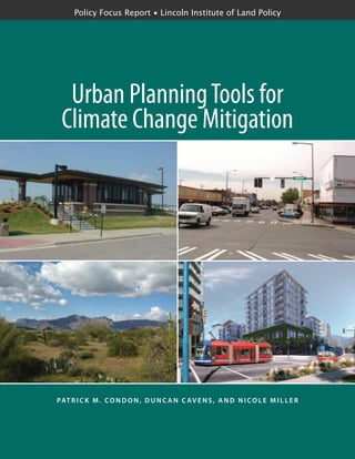
Figure 11 contrasts a household located
in a typical low-density, disconnected, single-
use neighborhood on the left with another in
a compact, connected, mixed-use neighbor-
hood on the right. The circle represents a 1
kilometer radius (the crow-fly buffer) from
each household. The analysis measured land
use patterns within the smaller, asymmetri-
cal 1 kilometer network buffer, which repli-
cates the area people can access within a six-
to ten-minute walk. The connected neigh-
borhood has many more nearby destinations
due to the higher densities, mixed land use
pattern, and interconnected street networks.
This set of neighborhood-scale urban
form measures was supplemented in the
analysis by other regional-scale measures
such as transit service levels and driving times
to address the impacts of regional location
and transit service on CO2
emissions.
Demographic and household characteris-
tics, such as income, number of workers,
and number of cars for each household,
were also taken into account.
Transport-related CO2
estimates were
generated from the PSRC travel survey trip
data by calculating CO2
emissions for each
link of each trip based on the road facility
type (e.g., for each trip, the distance traveled
on local streets, arterials, and freeways), time
of day (which determined congestion and
thereby travel speed), “cold starts,” and
vehicle occupancy. This approach provided
a more detailed estimate than could be
attained using a simple average speed for
individual trips.
The estimated emissions for each trip
link were then summed at the trip level and
linked to the urban form characteristics (in-
cluding net residential density, retail floor-
area ratio, intersection density, land use mix,
and park/retail/transit access) within the
1 kilometer walk-shed of each household.
The regression equations produced
by this analysis were programmed into
I-PLACE3
S, enabling the user to estimate
how different built environment scenarios
affect transport-related CO2
. I-PLACE3
S
calculates total and per capita CO2
at the par-
cel level for each scenario being evaluated.
White Center is one of the few remaining
unincorporated urban areas in King County,
so officials are strongly interested in making
it a more pedestrian-friendly community.
figure 11
Comparative Measurements of Land Use Patterns in Single-use and
Mixed-use Neighborhoods
Disconnected Connected
Crow-Fly Buffer
Sample Household
Network Buffer
Single Family Residential
Multi Family Residential
Commercial
Office
Industrial
Greenspace/Recreational
Parking
Unknown
Institutional
32. 30 p o l i c y f o c u s r e p o r t ● L i n c o l n I n s t i t u t e o f L a n d P o l i c y
...................
Zoning in the 98th Street corridor has been
changed to increase allowable densities and
to both allow and encourage mixed-use
development. A direct pedestrian walkway
connecting the Greenbridge Hope VI
public housing development to the center’s
commercial district is also being built.
I-PLACE3
S estimated that at full build-
out these changes would reduce daily house-
hold CO2
from transport from 14.17 to
13.94 kilograms (kg), adding up to a daily
reduction of 575 kg for what is a very small
study area (about 200 parcels). Additional
transit service in the area would reduce
per-household CO2
emissions further, to
12.9 kg per day.
Conclusions
More compact regions featuring walkable,
mixed-use centers connected by fast and
reliable transit service can lead to large reduc-
tions in per capita vehicle miles and hours of
travel. Local and regional government agen-
cies therefore have several options to reduce
GHG emissions from transportation: ex-
pansion or upgrading of transit service by
transit agencies; growth management and
regional-scale development patterns by state
or regional agencies; and neighborhood de-
sign through rezoning by local municipalities.
Geographically flexible and versatile
applications such as I-PLACE3
S can support
each of the above options. In its current en-
hanced version, this tool can inform planning,
zoning, development review, and transit/
transportation investments, as well as Health
Impact Assessment (HIA) in King County.
Research results from other urban regions
can also be incorporated into I-PLACE3
S,
creating a tool that is more broadly applica-
ble across the United States and Canada.
Its future expansion to allow estimation
of CO2
generated from building energy
operation, in addition to transport, would
make a household carbon footprint possible.
This would require obtaining data on build-
ing energy use from the local utilities in
King County and other urban areas.
Planners and developers have “an un-
precedented opportunity to shape the land-
scape” as they expand the built environment
to meet growing population needs over the
next 25 years (Nelson 2006). Tools such as
the enhanced version of I-PLACE3
S that
provide quantitative, locally relevant evidence
about the GHG–urban form relationship
will help to ensure that new development
minimizes the carbon footprint.
Case Study Consultant
Urban Design 4 Health (UD4H) is a leader
in the application of research assessing how
transportation and community design impacts
environmental and health-related outcomes
to practice-based decision-making contexts.
With a demonstrated track record of applying
evidence to real-world decisions at the neigh-
borhood, municipal, regional, and national
levels, UD4H focuses on informing policy
and planning decisions. Using a “pracademic”
approach, UD4H provides evidence-based
advice to its clients on the environmental,
health, mobility, and social implications of
contrasting fiscal and regulatory strategies.
The Greenbridge
Hope VI housing
development
33. c o n d o n , C av e n s & M i l l e r ● u r b a n p l a n n i n g t o o l s 31
...................
the ability to model the energy use, water
use, and carbon footprint of potential
development at the building, district, and
regional scenario levels.
Building Prototypes. Development of Envision
Tomorrow began with a tool called the Return
on Investment (ROI) model that tests the
physical and financial feasibility of hypothe-
tical development projects. The ROI model
can be used to develop building prototypes
ranging from single-family homes and mixed-
use buildings to regional retail malls and office
buildings. It can also measure housing and
employment densities, floor-area ratios, im-
pervious surfaces, construction costs, financial
feasibility, tax revenue, and other key attributes.
Envision Tomorrow: Using Prototype Buildings and Scenario
Modeling to Measure Carbon Footprint
Superstition Vistas, Arizona
The Tool
Envision Tomorrow, a suite of urban and
regional planning tools developed by Frego-
nese Associates, is used to model land use
decisions at a range of scales. At the site
level, this tool can be used to identify finan-
cially feasible development opportunities
and pinpoint ways to adjust existing land use
regulations to encourage new development.
At the neighborhood scale, various mixes
of buildings and other attributes (e.g., streets,
parkland) can be compiled to evaluate the
implications of different styles of develop-
ment. These buildings and development
types can be used to create land use scenarios
at the district, city, county, and regional scales.
The Envision Tomorrow tool also includes
A view of the
Superstition
Mountains from
part of the
study area
34. 32 p o l i c y f o c u s r e p o r t ● L i n c o l n I n s t i t u t e o f L a n d P o l i c y
...................
These building types can then be aggregated
and combined to form development types—
collections of buildings, streets, parks, and
civic areas.
Scenario Builder and Scenarios. The tool also
includes a Scenario Builder—an ArcMap GIS-
based modeling and evaluation application
capable of combining different development
types into a future growth scenario (figure 12).
Ranging from the neighborhood to the re-
gional scale, these scenarios are stories about
what might be, not forecasts or predictions.
They are possible futures based on what already
exists, evident trends, and the values and
preferences of the participants. The essential
requirement of any scenario is plausibility,
within the realm of what exists and what is
now known or can be reasonably conceived.
The Project
The Superstition Vistas project seeks to
demonstrate opportunities for sustainable
development in the Phoenix area that could
be an international model for energy- and
water-efficient development with a low car-
bon footprint. The 275-square-mile site at
the eastern edge of the Phoenix metropolitan
area spreads from the Superstition Moun-
tains Wilderness Area south to Florence, and
from the Pinal County line to the eastern
edge of Florence Junction (figure 13). This
figure 12
Steps for Modeling Land Use Scenarios
35. c o n d o n , C av e n s & M i l l e r ● u r b a n p l a n n i n g t o o l s 33
...................
state trust land is owned and managed by
the Arizona State Land Department for the
benefit of school children. Proceeds from
land sales are set aside and may be expended
only for educational purposes.
Anticipating that the project area may
eventually house more than one million peo-
ple, the East Valley Partnership (EVP) com-
missioned a study in 2007 to explore ways to
maximize long-term urban development sus-
tainability while generating long-term value
for education. The EVP, the project’s client,
is a coalition of civic, business, educational,
and political leaders from the East Valley of
the Phoenix metropolitan area. The EVP
advocates in areas such as economic devel-
opment, education, transportation, and in-
frastructure. The Sonoran Institute, another
key partner in the project, sums up the area’s
potential as the “singular most significant
planning opportunity in the United States”
(Dougherty 2009).
0 0.5 1 2 3 4 miles
0 2,500 5,000 10,000 15,000 20,00 feet
County Boundary
Concept Boundary
Limited Access
Highways
Highway Ramp
Secondary Roads
Other
Railroad
New Development
Road Network
Local Road, Rail (100’)
Major Road (150’)
Highway (200’)
Hydro
Floodplain
CAP (400’)
25% Slope
Road Setback
figure 13
Boundaries of the Superstition Vistas Project Area
36. 34 p o l i c y f o c u s r e p o r t ● L i n c o l n I n s t i t u t e o f L a n d P o l i c y
...................
The Methodology
The Envision Tomorrow scenario modeling
process is based on a development pattern
methodology, which grew out of the ROI
model that incorporates inputs, including
construction and land expenses, expected
rents, and sales prices, to evaluate a project
financially. Combinations of varied build-
ing prototypes, along with other urban
attributes such as streets, parks, and public
amenities, were then created to form a vari-
ety of development types, including urban
cores, traditional downtowns, town centers,
business parks, neighborhood retail, tradi-
tional neighborhoods, and residential
subdivisions.
The business park development type,
for example, is comprised of a mix of office
buildings and retail space, and includes acre-
age dedicated to right-of-way, parks, and
public facilities. These development types
serve as the building blocks for creating large-
scale regional scenarios. Each of the 20
development types used in the Superstition
Vistas project were created using up to
12 building types.
Expanding on this basic building proto-
type approach, the project incorporated
energy performance data into 12 prototype
buildings, ranging from single-family homes
to large mixed-use buildings and industrial
and office complexes. This involved the de-
velopment of a base energy use assumption,
along with three levels of improvement
representing 30 percent, 50 percent, and
80 percent reductions in energy use for
four different scenarios (figure 14).
Estimates of carbon dioxide emissions
were developed, as well as energy use from
electricity and natural gas. In each case, both
the additional costs and energy savings were
estimated, allowing the team to understand
the potential GHG emission implications
of different scenario designs in the project.
The Envision Tomorrow user builds land
use and transportation scenarios that repre-
sent a range of possible futures, essentially
by digitally painting the study landscape
with a range of possible development pat-
terns based on the results of public involve-
ment, the current trend, and coordinated
land use and transportation strategies. The
scenarios created can range from business-
as-usual to compact development in which
growth is concentrated in centers or along
corridors.
figure 14
Incremental Improvement Costs After Energy Reductions from Baseline
Scenario A Scenario B Scenario C Scenario D
IncrementalImprovementCosts
($billions)
25
20
15
10
5
0
Good (30% energy reduction)
Better (50% energy reduction)
Best (80% energy reduction)
37. c o n d o n , C av e n s & M i l l e r ● u r b a n p l a n n i n g t o o l s 35
...................
Outputs from the Scenario Builder can be
fed easily into the traditional four-step trans-
portation model. In the case of Superstition
Vistas, the Pinal County transportation model
was used to calculate traditional transportation
outputs along with estimates of the carbon
emissions from motorized vehicles (figure 15).
The final scenarios are subjected to a
series of tests to evaluate their individual im-
pact on the study area’s housing mix, trans-
portation network, environmental features,
open space, natural areas, and economic
development. Sustainability performance
measures are prioritized in these evaluations.
Furthermore, using the building prototype
as a methodological foundation enables
measurement of indicators that were pre-
viously difficult to calculate, such as the
increased value and probable rent levels for
residential and commercial buildings, the
amount of water consumed, the number
of retail employees, and even the total
area of rooftops or parking lots.
Conclusions
Through the application of the Envision
Tomorrow’s development type methodology
in Superstition Vistas and other projects, a
number of patterns and design lessons have
emerged. While this work is in its prelimi-
nary stages, it appears that the concept of
using building prototypes to model large-
scale scenarios is a powerful one that can
be used in a variety of applications.
• Building in a “greener” fashion is a key strategy.
In the past many land use scenarios have
focused on efficient land use that reduces
transportation expenditures. This is effec-
tive, but the impact of developing build-
ings to a greater level of energy efficiency
is often several times more efficient in
reducing greenhouse gas emissions and
energy consumption.
• The combination of multimodal land use and
transportation design and building improvements
can have a huge impact on carbon emissions.
Preliminary results from the Superstition
Vistas work indicate reductions of 50
to 60 percent in carbon emissions are
possible with good design and current
technologies.
• Developing higher density building forms can
reduce their carbon impact while accommodating
the same population forecast. The end result
is that on a per capita basis the buildings
consume less energy and have a smaller
carbon footprint, even without any in-
vestment in energy efficiency. In the case
figure 15
Total Carbon Footprint of Annual Building and Transportation Emissions
10
9
8
7
6
5
4
3
2
1
0
TonsofCO2
(millions)
Scenario A Scenario B Scenario C Scenario D
Baseline
Best
38. 36 p o l i c y f o c u s r e p o r t ● L i n c o l n I n s t i t u t e o f L a n d P o l i c y
...................
of Superstition Vistas, the more compact
scenarios reduced carbon emissions by
20 to 25 percent, even without any im-
provements in building technology.
• The costs of improving energy efficiency vary
widely among the prototype buildings. Some
building types may have considerably
higher costs than others to achieve com-
parable improvements; this is important
to consider when designing policy recom-
mendations. If it is very expensive to
achieve energy reductions in some build-
ing types, the funds might be better spent
in developing carbon neutral energy gen-
eration, rather than in energy conservation.
• Achieving a better jobs/housing balance is a key
to reducing transportation-related carbon emis-
sions. A low carbon footprint from trans-
portation sources is difficult to achieve
without a successful economic develop-
ment program. Additionally, the housing
stock has to be affordable for the local
workforce, otherwise commuters will be
forced to travel longer distances from
areas that are affordable, thus increasing
carbon emissions from transportation.
Case Study Consultant
Fregonese Associates in Portland, Oregon,
has been creating and applying development
types as a way to model future growth and
development since the early 1990s. This
approach achieves effective simulation of
building scale and density, pedestrian-friend-
liness, and transit-orientation while working
at a neighborhood, citywide, or regional
scale. Evolving from the early development
types first used in Portland Metro’s 2040
process, Envision Tomorrow can be used to
create a range of land use scenarios quickly,
and at a number of different scales.
39. c o n d o n , C av e n s & M i l l e r ● u r b a n p l a n n i n g t o o l s 37
...................
The Tool
A Development Pattern Approach (DPA)
methodology was applied during this collab-
orative process to evaluate the energy and
GHG implications of various urban form
scenarios, both baseline conditions and
future visions, and to support informed
stakeholder decision making.
Development patterns are discrete and
replicable representations of specific ele-
ments of urban form that can be combined
spatially and quantitatively into cities or
regions. They can be used to approximate
present-day land use conditions, or create
desired future scenarios. The urban form
characteristics include land use mix, devel-
opment densities, street patterns, housing
types, building geometries, commercial and
residential floor areas, and block and parcel
configurations (figure 16). Beyond this, de-
velopment patterns represent several distinct
functions of urban form: corridors, nodes,
and fabric (the areas of land existing be-
tween a network of corridors and nodes).
In this North Vancouver project, the De-
velopment Pattern Approach was expanded
to allow for calculation and mapping of
GHG emissions. The development patterns
were used as inputs to two models that mea-
sured the scenarios’ building- and transpor-
tation-related GHG consequences.
They also were used to build representa-
tions of the present (2007) development sce-
nario, as well as the 100-year development
scenario produced by stakeholders and proj-
ect participants. This allowed researchers to
estimate GHG emissions for both scenarios,
and produce spatial and visual GHG maps
representing emissions intensity across the
city. In turn, this enabled visual comparisons
between the city’s current conditions and
future alternatives, helping stakeholders in-
corporate low-GHG land use decisions into
the concept plan (figure 17).
The Project
The 100 Year Sustainability Vision was a
multistage project conducted in the City of
North Vancouver in 2007–2008 to develop
Development Pattern Approach:
Measuring GHG Impacts of Land Use Decisions
City of North Vancouver, British Columbia
Current and
simulated views
illustrate the inter-
section of Londsdale
Avenue and 8th
Street in 2007,
2050, and 2107.
40. 38 p o l i c y f o c u s r e p o r t ● L i n c o l n I n s t i t u t e o f L a n d P o l i c y
...................
a long-term sustainable concept plan to
accommodate significant population growth
while creating a vibrant, diverse, and highly
livable community able to provide for social
and economic needs within a carbon neutral
environment. Guided by the Province of
British Columbia’s recently introduced Green-
house Gas Reduction Targets Act, the proj-
ect also aimed to create a plan to reduce
GHG by 80 percent below 2007 levels by
2050, and to achieve zero net emissions
by 2107.
The collaborative project engaged local
and regional community stakeholders, city
staff, utilities representatives, researchers,
and others in a planning process over several
months, culminating in a four-day intensive
design charrette. During this process, stake-
holders worked with project researchers to
assess alternative development scenarios and
generate a long-term, low-GHG vision for
the city (figures 18 and 19).
The Methodology
The development patterns used in this proj-
ect were constructed from information con-
tained in a database created and maintained
by the ElementsLAB research group within
the Design Centre for Sustainability at the
University of British Columbia. This data-
base contains a comprehensive collection of
parcel-scale examples of streets, open spaces,
and buildings across a range of densities
and forms.
Each of these examples contains visual
and quantitative information, including
three-dimensional digital models, site plans,
and data on floor-area ratios, uses, parcel
coverage, and number of residential units.
These street, open space, and building cases
can be assembled using spreadsheets, GIS,
or other spatial modeling platforms such as
Google SketchUp to generate development
patterns. Replacing one case for another can
quickly generate variations of patterns; for
figure 16
Parcel, Street, and Open Space Cases in a Development Pattern
Parcel Cases
Street Cases
Open Space cases
patterns
figure 17
Development Patterns Assembled into Scenarios
Pattern A
Pattern B
Pattern C
CITY OR REGIONAL
SCENARIOS
41. c o n d o n , C av e n s & M i l l e r ● u r b a n p l a n n i n g t o o l s 39
...................
figure 18
Initial Sketch Digitized for a GIS Development Pattern Map
figure 19
Development Patterns as Assigned in GIS During the Charrette
42. 40 p o l i c y f o c u s r e p o r t ● L i n c o l n I n s t i t u t e o f L a n d P o l i c y
...................
example, a single-family house case might
be replaced by a duplex within a pattern
to explore the impacts of densification.
To model the energy demand and GHG
emissions from the buildings in the scenarios,
building energy profiles—quantitative de-
scriptions of energy consumption by end use
and energy source—were created for each
type of building used in the development
patterns: single-family detached houses;
duplexes; row houses; low-rise apartments;
high-rise apartments; commercial build-
ings; institutional buildings; and industrial
buildings.
The model used to calculate energy
consumption was very simple: using a per
unit (for residential buildings) or per square
meter (for other buildings) annual energy
demand estimation, total energy demand
was derived for the entire development
pattern. The data used to calculate energy
consumption was derived from current
aggregate figures for the entire region, while
future energy consumption was calculated
by taking into consideration changes in
building technologies, energy source, and
changes in user behavior.
The model used to calculate transpor-
tation demand and associated emissions is
presently coarse and under further develop-
ment. Transportation-related GHG calcula-
tions in this project were limited to trips that
begin or end at a residential unit within the
project area. While this definition does not
capture all transportation GHG emissions
(in particular, it misses the considerable GHG
emissions of people traveling from other loca-
tions to the project area to shop or work), it
was deemed suitable for the purposes of the
charrette process, which was targeted at the
ability of the local government to reduce
resident-based emissions.
The transportation-related GHG emis-
sions for each development pattern were
modeled as a product of the types of units
(different unit types generate different num-
bers of trips/day, with stacked and attached
units generating fewer than larger single-
family units), total trip length, vehicle effi-
ciency/fuel assumptions, and mode split.
Conclusions
The City of North Vancouver’s 100 Year
Sustainability Vision project is one of the
first municipal-level projects in British
Columbia to consider how specific land
use, building form, transportation, and
infrastructure decisions will contribute to
reducing energy consumption and GHG
emissions, while supporting other envi-
ronmental, social, and economic goals.
The development pattern method for
quantifying and spatializing GHG emissions
used by this project created a standardized
and consistent means of measuring and
comparing alternative land use scenarios—
from current conditions for which a wide
variety of data exists to a 100-year future
about which relatively little is known. Rath-
er than making time-consuming, parcel-by-
parcel design decisions, project participants
were able to assign general land use patterns
to all areas of the city, while adding greater
amounts of detail to sensitive or otherwise
important areas (figures 20 and 21).
Additionally, the quantitative and design-
based results of the project suggest that the
DPA methodology has significant potential
to inform decision making on urban form
and GHG emission reductions during a
fast-paced, collaborative planning process.
Development patterns support iterative
decision making. Using this approach to
discuss and evaluate urban form decisions
during the design charrette allowed for live
feedback from researchers using GIS analy-
sis on performance issues such as population
and job targets, thereby informing iterative
revisions of the 100-year vision to be ad-
justed during the four-day charrette.
43. c o n d o n , C av e n s & M i l l e r ● u r b a n p l a n n i n g t o o l s 41
...................
figure 20
Spatialization of Energy Demand per Unit for 2007 Baseline
Current Conditions
Energy Demand Per Unit
30 GJ/Unit per Year
75 GJ/Unit per Year
150 GJ/Unit per Year
figure 21
Spatialization of Energy Demand per Unit for Charrette Scenario
Charrette Plan
Energy Demand Per Unit
30 GJ/Unit per Year
75 GJ/Unit per Year
150 GJ/Unit per Year
44. 42 p o l i c y f o c u s r e p o r t ● L i n c o l n I n s t i t u t e o f L a n d P o l i c y
...................
Because development patterns use the
same types of planning data commonly
available to local governments, the concept
plan developed during the charrette is read-
ily translatable to future policy and imple-
mentation processes, such as density targets,
land use designations, and building design
guidelines.
This project represents a first attempt
to address the complex issues of GHG
emissions accounting and reductions, urban
design, long-term decision making, land use
and transportation planning, and collabora-
tive planning processes. While the results
of this project are encouraging, additional
research will be required to improve the de-
velopment pattern methodology. Ongoing
work to improve the approach includes:
• adding additional detail to the underly-
ing building cases to allow development
patterns to take into account parcel-level
variations in building design, vintage,
or mechanical systems;
• linking the DPA method with existing
transportation models, including Univer-
sity of Toronto’s TASHA model (Roorda,
Miller, and Habib 2008) and MATSIM
(Balmer et al. 2008) in order to improve
the validity of the transportation-related
GHG estimates;
• improving the representation of block-
level considerations such as building ori-
entation and shading that may further
affect building energy consumption;
• developing proxy measures for patterns
to represent renewable energy potential;
and
• improving the level of automation in
the software components to allow faster
turn-around during charrette events.
In spite of these needed changes, the Devel-
opment Pattern Approach represents a sig-
nificant step forward in providing a model-
ing tool that can both evaluate GHG impli-
cations of different planning scenarios and
be integrated into charrettes, workshops,
and other typical planning processes.
Case Study Consultant
The University of British Columbia’s De-
sign Centre for Sustainability is an academic
leader in applying sustainability concepts
to the development of land, cities, and com-
munities. DCS has led a range of research
and on-the-ground projects incorporating
background research, processes, and tools
for shifting community planning and design
toward a consideration of sustainability as
a matter of course, rather than exception.
The City of North Vancouver project was
the fifth case study of the DCS Sustainabil-
ity by Design program, a multiyear collabor-
ative effort to produce a visual representa-
tion of what the Greater Vancouver region
might look like in 2050, at neighborhood-,
district-, and region-wide scales.
45. c o n d o n , C av e n s & M i l l e r ● u r b a n p l a n n i n g t o o l s 43
...................
c h a p t e r 5
Conclusions and Recommendations
C
ities and other urbanized areas
are home to more than half of
the world’s population and have
generated the lion’s share of GHG
emissions. A better understanding of the
links between urban form and GHG emis-
sions is essential to create successful climate
change mitigation strategies.
To aid in performing this vital task, a tool,
or suite of tools, must be capable of provid-
ing a broad set of measurements and evalu-
ative criteria. Available tools, including
some not described in this report, are still
incomplete, difficult to access, or challeng-
ing to use. Some require the guidance of
skilled operators and large amounts of time
and resources, while others are so oversim-
plified that they lose the ability to model
the relationship between urban planning
and GHG emissions.
While no one tool can yet address all
of the desiderata identified by officials and
experts in our research and conferences to
date, the potential to build on the strengths
of existing tools is promising. Continued
tool development will serve to enhance con-
nections among various tools, create new
methods of evaluating urban form and GHG
emissions, and establish test cases through
which new tools can be applied and refined.
An ideal tool or integrated suite of tools
should have the following characteristics.
Comprehensive
The tool should capture the GHG contribu-
tions of all relevant sectors, including build-
Providence,
Rhode Island
46. 44 p o l i c y f o c u s r e p o r t ● L i n c o l n I n s t i t u t e o f L a n d P o l i c y
...................
ings and transport, and support the consid-
eration of additional criteria related to the
economy and livability. Sustainable urban
design issues overlap, so the consequences
of GHG-oriented decisions on associated
concerns need to be revealed clearly. For ex-
ample, a climate-focused planning strategy
could have a serious impact on housing
costs. Absent realistic assessment of these
costs, decisions about future housing develop-
ment might be rendered counterproductive
or politically infeasible.
Three-dimensional
The tool should be grounded in the three-
dimensional physical realities of the urban
spaces it seeks to model. Moreover, tools
should provide vivid and accurate descrip-
tions of the consequences of future com-
munity design to avoid inhibiting the ability
of planners to communicate the real-world
implications of proposed actions.
Multi-scalar
The tool should be able to connect top-
down (from regional and higher levels to
the block scale) with bottom-up analysis,
responding to the interactions between in-
cremental site-scale decisions and regional
and higher-level decisions on GHG emis-
sions. This would require a facility to assess
both a single-family subdivision and a new
freeway, for example.
Policy-relevant
The tool should be supportive of the way
policy is made and implemented, in terms
that are direct and useful to decision makers.
The tool must move fluidly between process-
es that generate GHG performance
data and the policies that might influence
this performance.
Iterative
The tool should have the capacity to test
alternative scenarios in real time, including
within multi-stakeholder decision processes
and design and planning charrette environ-
ments, in order to produce results that can
be evaluated rapidly and incorporated into
plan modifications and improved outcomes.
Source: Design Centre for
Sustainability. University
of British Columbia