Rainwater harvesting practices and design of rainwater harvesting system for ...
Community evolved model for restoration and management of a dying water source - David K. Nkwanga, Nature Palace Foundation, Uganda
1. COMMUNITY EVOLVED MODEL FOR RESTORATION AND MANAGEMENT OF A DYING WATER SOURCE
David K. Nkwanga, Nature Palace Foundation. info@naturepalace.net
Introduction
River Bukoola found in the semi-arid Rakai District in the south-western part of Uganda is
approximately 70 kilometres long - joining two water bodies: Lakes Kijanebalora and Victoria. All along
its course, R. Bukoola has for decades served a significant role to the local population as:
population as:
•Stands as key feature in aiding local population
•Source of Water for animals
adaptation to Climate Change:
•Sources of Water for Off-season
agriculture
•Source of Water for Human Consumption
However, over last five years the water levels of the river drastically dwindled due to effects of climate
change coupled with indiscriminate destruction of its banks through tree cutting, uncontrolled grazing
and river bank gardening, exposing the population and their animals to extreme vulnerability and
threatened livelihoods.
Community Response
Facilitated by Nature Palace Foundation, the community has developed an integrated water
conservation and management model that involves river-bank restoration, water governance through
water management committees and a wider watershed management plan. The community-evolved
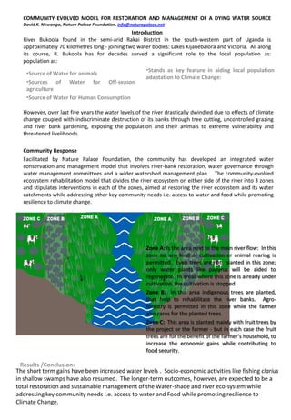
ecosystem rehabilitation model that divides the river ecosystem on either side of the river into 3 zones
and stipulates interventions in each of the zones, aimed at restoring the river ecosystem and its water
catchments while addressing other key community needs i.e. access to water and food while promoting
resilience to climate change.
Zone A: Is the area next to the main river flow: In this
zone no any kind of cultivation or animal rearing is
permitted. Even trees are not planted in this zone;
only water plants like papyrus will be aided to
regenerate. In areas where this zone is already under
cultivation, the cultivation is stopped.
Zone B: In this area indigenous trees are planted,
that help to rehabilitate the river banks. Agro-
forestry is permitted in this zone while the farmer
also cares for the planted trees.
Zone C: This area is planted mainly with fruit trees by
the project or the farmer - but in each case the fruit
trees are for the benefit of the farmer’s household, to
increase the economic gains while contributing to
food security.
Results /Conclusion:
The short term gains have been increased water levels . Socio-economic activities like fishing clarius
in shallow swamps have also resumed. The longer-term outcomes, however, are expected to be a
total restoration and sustainable management of the Water-shade and river eco-system while
addressing key community needs i.e. access to water and Food while promoting resilience to
Climate Change.