
Recommended
More Related Content
Recently uploaded
Recently uploaded (20)
Featured
Featured (20)
Geoscape Market Snapshot of the New Orleans DMA
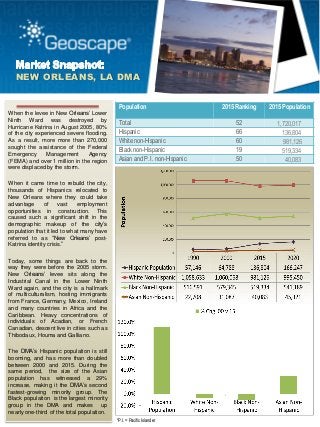
- 1. NEW ORLEANS, LA DMA When the levee in New Orleans’ Lower Ninth Ward was destroyed by Hurricane Katrina in August 2005, 80% of the city experienced severe flooding. As a result, more more than 270,000 sought the assistance of the Federal Emergency Management Agency (FEMA) and over 1 million in the region were displaced by the storm. When it came time to rebuild the city, thousands of Hispanics relocated to New Orleans where they could take advantage of vast employment opportunities in construction. This caused such a significant shift in the demographic makeup of the city’s population that it led to what many have referred to as “New Orleans’ post- Katrina identity crisis.” Today, some things are back to the way they were before the 2005 storm. New Orleans’ levee sits along the Industrial Canal in the Lower Ninth Ward again, and the city is a hallmark of multiculturalism, hosting immigrants from France, Germany, Mexico, Ireland and many countries in Africa and the Caribbean. Heavy concentrations of individuals of Acadian, or French Canadian, descent live in cities such as Thibodaux, Houma and Galliano. The DMA’s Hispanic population is still booming, and has more than doubled between 2000 and 2015. During the same period, the size of the Asian population has witnessed a 29% increase, making it the DMA’s second fastest-growing minority group. The Black population is the largest minority group in the DMA and makes up nearly one-third of the total population. Population 2015 Ranking 2015 Population Total 52 1,720,017 Hispanic 66 136,804 White non-Hispanic 60 981,126 Black non-Hispanic 19 519,334 Asian and P. I. non-Hispanic 50 40,083 *P.I. = Pacific Islander
- 2. NEW ORLEANS, LA DMA 12% 18% 37% 20% 13% Percent Black Households by SES Level Socioeconomic Status A Socioeconomic Status B Socioeconomic Status C Socioeconomic Status D Socioeconomic Status E Nearly 40% of Black households are classified as SES C and have an annual income between $30,000 and $75,000. ZIP Code Pop. Count: Acadian/Cajun Ancestry 70301 835 70364 800 70345 780 70394 521 70373 512 70363 375 70374 332 70360 294 70094 283 70072 263 70344 254 70354 246 70123 205 70433 190 70068 182 70065 170 70003 157 70357 151 70377 151 70001 145 Top 20 ZIP Codes by Acadian/Cajun Ancestry 3% 64% 31% 1% Hispanic White non-Hispanic Black non-Hispanic Asian and Pacific Islander non-Hispanic Today, nearly one-third of the total population is Black non-Hispanic; however, between 2000 and 2015 the growth rate of this segment has decreased over 10%.
- 3. NEW ORLEANS, LA DMA P. 888.211.9353 | E. geoscape@geoscape.com | URL. www.geoscape.com Source: Geoscape American Marketscape DataStream™ and/or Consumer Spending Dynamix™ Series 2015 The Designated Market Area (DMA) boundaries are defined by Nielsen. Socio-Economic Status (SES) is a Geoscape proprietary Culture Code® that comprises a blend of income, education, occupation and housing characteristics. SES helps identify consumer purchasing power and preferences. Households are grouped into common segments as an A-E index or percentile ranking (values 1-100) by ZIP Code, Census Tract or Block Group. "A" and "100" are the highest levels of socioeconomic status while "E" and "1" are lowest levels. A concentration of Black households with an annual income between $50,000 and $120,000 is located in ZIP code 70355 within Gheens, Louisiana.
- 4. NEW ORLEANS, LA DMA This Market Snapshot is produced by Geoscape using the Geoscape Intelligence System (GIS) and the American Marketscape DataStream™ Series 2015 and Consumer Spending Dynamix™ Series 2015. For a FREE test drive of GIS, point your browser to: http://gis.geoscape.com/testdrive/ Copyright 2015 © All rights reserved. Reproduction rights are granted provided the material is reproduced in its entirety and sourced to Geoscape and the American Marketscape DataStream, Series 2015 P. 888.211.9353 | E. geoscape@geoscape.com | URL. www.geoscape.com Source: Geoscape American Marketscape DataStream™ and/or Consumer Spending Dynamix™ Series 2015 The Designated Market Area (DMA) boundaries are defined by Nielsen. The heaviest concentrations of individuals of Acadian descent are located in cities such as Thibodaux, Raceland, Houma and Galliano.