Popham Beach Erosion
•
2 likes•904 views

Erosion has transformed Popham beach; dunes have vanished and trees are uprooted.

Recommended
More Related Content
More from mainenaturediary
More from mainenaturediary (20)
Recently uploaded
Recently uploaded (20)
Popham Beach Erosion
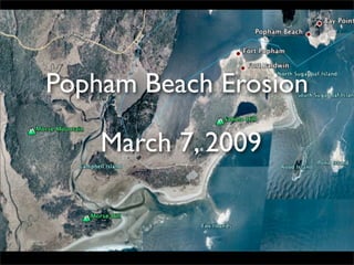
- 1. Popham Beach Erosion March 7, 2009
- 2. Dune/Bluff eroded away Morse River Fox Island Erosion: Today was a gorgeous, sunshiny day with temperatures in the high 40’s. We decided to visit Popham Beach State Park for a nice walk on the sand. This is our favorite beach and we were shocked at its transformation since we had last visited it in 2007. In this Google Earth photo (from about 8 years ago) you can see the southward facing line of trees followed by dune/bluff grasses and then the white sand beach. Well...the dune/bluff area (under the arrow) has completely eroded away on the west side of the parking lot toward Morse River. The river now cuts across the beach area and flows between Popham Beach and Fox Island. The pine forest is slowly toppling.
- 3. Path to the beach...We were shocked as we walked to the beach because this view used to be all beach bluff, rugosa rose bushes, and dune grasses. There was always an air of anticipation as we peered over the bluff to the beach.
- 4. Beach Scene: This view looks south, across the beach toward the Gulf of Maine, at low tide. This really hasn’t changed much over the years as it is still a great expanse of sand.
- 5. Looking West: Note the fallen Pitch Pine trees all along the bluff. The erosion is greatest here.
- 6. Bluff Erosion: Bluff erosion can be much more dramatic that beach erosion. The pitch pine (Pinus rigida) forest has been growing here for at least 50 years, and the leading edge is falling onto the beach.
- 7. Dramatic Bluff Erosion: It was amazing to see the sand pulled out from underneath the mat of dune grass.
- 8. Exposed Roots: The roots no longer have anything to hold onto and the trees topple onto the beach.
- 9. Pitch Pine Cones and Needles: These pine trees grow on sandy barrens, and are common in the southern part of the state. Note the rough bark. The needles are in clusters of three.
- 10. View looking toward the southeast: We walked to the western edge of the beach toward Morse River.You can see a bit of the river cutting across the sand. This entire area is covered by the ocean at high tide, which only leaves a thin strip of sand to walk on.
- 11. Morse River and the edge of Morse Hill: The river flows toward the beach and is banked by Morse HIll and Morse Mountain on the right. Nobody knows what the future will bring, but the river has been known to change its course in the past. In fact, it caused similar erosion events to Popham Beach in 1964, 1972, and 1987 when it “breached a sand bar at low tide. At high tide, the new river channel scoured away the dunes, bringing the river right to the pitch pine forest.” http://morningsentinel.mainetoday.com/news/local/4980255.html
- 12. Patterns in the sand: Sand patterns can tell a scientist a lot about the movement of water on the beach. I don’t know what this pattern means, but there is a good explanation of various sand patterns on the Maine Geological Survey web site.
- 13. Weathered Wood: Many dead trees get exposed to wind and water over the years.
- 14. The End ✴ Photos 3-14 are property of Laurie Haines. Please ask permission if you would like to use them in another venue besides this slide presentation. ✴ Photos 1 & 2 are property of Google Earth. ✴ http://mainenaturediary.com