SlideShare a Scribd company logo
1 of 10
Download to read offline
ViaMichelin                                                                     http://www.viamichelin.fr/web/ItineraryPrint


              Itinéraire imprimé le14/04/2010


                     Départ :          71200 Saint-Sernin-du-Bois    Temps : 05h56
                     Etape A :         42300 Roanne                  Distance : 289 km
                                                                     Coût total : 30.13 EUR
                     Arrivée :         07440 Alboussière


                                           Votre feuille de route
                             Départ : Saint-Sernin-du-Bois, Centre


                             Sortir de Saint-Sernin-du-Bois                            2 km

                                                                                              2 km 00h04
                             Traverser Les Vernizeaux                              0.9 km

1 sur 10                                                                                                   14/04/2010 18:44
ViaMichelin                                                                                http://www.viamichelin.fr/web/ItineraryPrint


                     Traverser Le Creusot                                                    6.5 km

                          Continuer sur : Rue Goujon                                         (0.4 km)
                          Continuer sur : D138 / Route de Saint-Sernin                       (1.5 km)
                              Succession de virages sur 0.3 km                                          3.5 km 00h08

                          Prendre D138 / Rue des Martyrs de la Libération                    (0.1 km)
                              Au rond-point, Place Charles de Gaulle, prendre la 2nde sortie (0.1 km)
                          Continuer sur : D984 / Avenue François Mitterrand
                             Au rond-point, prendre la 3ème sortie Continuer sur : Allée     (0.9 km)
                          Jean Perrin
                          Prendre Allée Gustave Eiffel                                       (0.6 km)
                              Prendre à droite : Boulevard de l'Industrie                    (0.2 km)

                              Prendre à gauche : Rue Baptiste Marcet                         (0.2 km)
                              Prendre à gauche : Rue des Acacias                             (0.3 km)

                              Prendre à gauche : D28 / Rue Albert 1er                        (0.6 km)
                          Continuer sur : D28                                                (1.5 km)
                          Sortie de Le Creusot
                                                                                                        9.5 km 00h24
              D28    Continuer sur : D28                                                      0.4 km

                                                                                                        9.5 km 00h24
                     Traverser Torcy                                                         3 km

                          Continuer sur : D28                                                (0.7 km)
                              Au rond-point, prendre la 1ère sortie Continuer sur : N80      (0.7 km)
                              Prendre à gauche : Route du Centre                             (0.6 km)
                              Virage à droite                                                           11 km 00h26

                          Continuer sur : Route du Centre                                    (0.8 km)
                          Sortie de Torcy
                                                                                                        13 km 00h28
                     Continuer sur : Route du Centre                                           2.5 km

                                                                                                        15 km 00h31
                     Au rond-point, prendre la 2nde sortie                                       4 km

                                                                                                        19 km 00h35
                     Prendre à droite : N70 / E607 en direction de :                             3 km
              N70                      MONTCEAU
                                        MOULINS
              E607                   BLANZY-CENTRE


                              Prendre sortie en direction de :                                          21 km 00h37

                              MONTCEAU-LES ALOUETTES


2 sur 10                                                                                                               14/04/2010 18:44
ViaMichelin                                                                                http://www.viamichelin.fr/web/ItineraryPrint


                                                                                                        22 km 00h38
                     Traverser Blanzy                                                        0.6 km

                          Continuer tout droit                                               (0.4 km)
                          Continuer sur : Avenue du Maréchal Leclerc                         (0.2 km)
                          Sortie de Blanzy
                                                                                                        23 km 00h39
                     Traverser Montceau-les-Mines                                            5 km

                          Continuer sur : Avenue du Maréchal Leclerc                         (1.3 km)
                              Prendre à gauche : D974 / Quai Jules Chagot                    (1.4 km)

                          Prendre D974                                                       (2 km)
                          Sortie de Montceau-les-Mines
                                                                                                        28 km 00h51

              D974   Continuer sur : D974                                                      0.8 km

                              Succession de virages sur 0.8 km                                          28 km 00h51
                                                                                                        29 km 00h51
                     Traverser Saint-Vallier                                                0.8 km

                          Continuer sur : D974                                              (0.5 km)
                          Continuer tout droit                                              (<0.1 km)
                              Au rond-point, prendre la 1ère sortie Continuer sur : D235    (0.3 km)

                          Sortie de Saint-Vallier
                                                                                                        29 km 00h52
              N70    Prendre à gauche : N70 / E607 en direction de :                           25 km
                                             N70
              E607
                                         ROANNE
                                         MOULINS
                                          VICHY
                                      CIRY-LE-NOBLE
                                     PARAY-LE-MONIAL


                          Traversée de Ciry-le-Noble                                                    32 km 00h55
                                                                                                        55 km 01h12
                     Continuer sur : N79 / E607 / E62                                            4 km
              N79
                              Prendre sortie en direction de :                                          59 km 01h14
              E607
                                        SAINT YAN
                                 VITRY-EN-CHAROLLAIS
                                 PARAY-LE-MONIAL-SUD

                                                                                                        59 km 01h15
                     A Vitry-en-Charollais, Au rond-point, prendre la 4ème sortie en direction 0.4 km
                     de :
                                         D979
                                  CHALON-SUR-SAÔNE
                                 MONTCEAU-LES-MINES
                                        SAINT-YAN
                            VITRY-EN-CHAROLLAIS-LE-BOURG
                                 PARAY-LE-MONIAL-SUD
                              ZONE INDUSTRIELLE LE MONT


                                                                                                        59 km 01h15
              D979   Au rond-point, prendre la 3ème sortie Continuer sur : D979                1.1 km


3 sur 10                                                                                                              14/04/2010 18:44
ViaMichelin                                                                              http://www.viamichelin.fr/web/ItineraryPrint


                                                                                                      60 km 01h16
                     Traverser Paray-le-Monial                                             3 km

                         Continuer sur : D979                                              (1.4 km)
                             Prendre à droite : D352BIS / Route de Saint-Yan               (1.4 km)

                         Sortie de Paray-le-Monial
                                                                                                      63 km 01h22
                     Prendre D352BIS                                                         7.5 km

                                                                                                      71 km 01h29
              D982   Continuer sur : D982                                                    12 km

                                                                                                      83 km 01h39
                     Tourner à gauche                                                        0.1 km

                                                                                                      83 km 01h39
                     Traverser Marcigny                                                   3.5 km

                         Continuer sur : Rue des Abergeries                               (1.4 km)
                             Prendre à droite : Rue du Général de Gaulle                  (0.1 km)
                             Prendre à droite : D989 / Rue du 8 Mai 1945                  (<0.1 km)

                         Prendre D989                                                     (0.1 km)
                             Prendre à gauche : Rue de Précy                              (0.1 km)

                             Prendre à gauche : Rue des Remparts                          (<0.1 km)
                             Prendre à droite : Rue de Borchamp                           (1.4 km)

                             Prendre à gauche : D982                                      (<0.1 km)
                         Sortie de Marcigny
                                                                                                      86 km 01h45
              D982   Continuer sur : D982                                                    9.5 km

                            RADAR : D982 borne km 29.3 (90 km/h), au niveau de Saint-                 89 km 01h47
                         Martin-du-Lac.
                                                                                                      96 km 01h54
              D482   Continuer sur : D482                                                   15 km

                         Traversée de Briennon                                                       96 km   01h54
                            RADAR : D482 borne km 6.4 (50 km/h), au niveau de Pouilly-               101 km 02h00
                         sous-Charlieu.
                                                                                                     111 km 02h10
                     Entrer dans Roanne                                                  4 km

                         Continuer sur : Rue de Charlieu                                 (3.5 km)
                         Continuer sur : Avenue de Lyon                                  (0.1 km)
                             Prendre à gauche : Rue Alexandre Roche                      (0.2 km)

                         Prendre Place Georges Clemenceau                                (<0.1 km)
                         Continuer sur : Place du Maréchal de Lattre de Tassigny         (0.1 km)
                         Continuer sur : Rue du Château                                  (<0.1 km)
                             Prendre à gauche : Rue des Aqueducs                         (0.1 km)

                             Prendre à gauche : Rue de Cadore                            (0.1 km)
                                                                                                     115 km 02h20


4 sur 10                                                                                                             14/04/2010 18:44
ViaMichelin                                                                                 http://www.viamichelin.fr/web/ItineraryPrint


                      Etape A : Roanne, Centre

                                                                                                        115 km 02h20
                      Sortir de Roanne                                                       1.3 km

                           Prendre Rue Roger Salengro                                        (0.5 km)
                               Prendre à droite : Avenue de Lyon                             (0.4 km)

                               Au rond-point, prendre la 3ème sortie Continuer sur : D504    (0.5 km)

                           Sortie de Roanne
                                                                                                        116 km 02h24
                      A Le Coteau, Prendre Avenue de la Libération                              3 km

                                                                                                        119 km 02h28
              D207    Prendre D207                                                              4 km

                           Traversée de Parigny                                                         120 km 02h29
                                                                                                        123 km 02h33
                      Traverser L'Hôpital-sur-Rhins                                          0.9 km

                           Continuer sur : D207                                              (0.7 km)
                           Prendre D907                                                      (0.2 km)
                           Sortie de L'Hôpital-sur-Rhins
                                                                                                        124 km 02h34
              D907    Continuer sur : D907                                                     0.7 km

                               Virage à droite                                                          125 km 02h35

                                                                                                        125 km 02h35
                      Au rond-point, prendre la 2nde sortie Continuer sur : N82 en direction de
                      :                                                                         16 km
              N82
                                               N82
                                           A72
                                      SAINT-ETIENNE
                                    CLERMONT-FERRAND
                                         NEULISE


                               Virage à droite                                                          138 km 02h44

                                                                                                        141 km 02h46
              D1082   Continuer sur : D1082 en direction de :                                   4 km
                                             BALBIGNY
                                              FEURS


                           Traversée de Balbigny                                                        143 km 02h47
                                                                                                        145 km 02h51
                      Continuer tout droit                                                   <0.1 km

                                                                                                        145 km 02h51
              D1082   Au rond-point, prendre la 2nde sortie Continuer sur : D1082 en direction 7.5 km
                      de :
                                            N82
                                       SAINT-ETIENNE
                                           FEURS


                           Traversée de Épercieux-Saint-Paul                                            147 km 02h53


5 sur 10                                                                                                               14/04/2010 18:44
ViaMichelin                                                                                 http://www.viamichelin.fr/web/ItineraryPrint


                                                                                                           152 km 02h58
                      A Feurs, Prendre à gauche : Rue du 8 Mai                                    0.5 km

                                                                                                           153 km 02h58
              D89     Prendre à droite : D89 / Place du Forum                                     0.1 km

                                                                                                           153 km 02h59
                      Continuer tout droit                                                       <0.1 km

                                                                                                           153 km 02h59
                      Au rond-point, prendre la 2nde sortie Continuer sur : Rue Philibert         0.2 km
                      Mottin en direction de :
                                           LYON
                                        PANISSIÈRES
                                        L'ARBRESLE


                                                                                                           153 km 02h59

                      Prendre à droite : Rue de Verdun en direction de :                           1 km
                                       SAINT-ETIENNE


                                                                                                           154 km 03h01
              D1082   Prendre D1082 / Route de Saint-Etienne                                      0.6 km

                                                                                                           155 km 03h01
                      Continuer tout droit                                                       <0.1 km

                                                                                                           155 km 03h01
              D1082   Au rond-point, prendre la 2nde sortie Continuer sur : D1082 / Route de      0.5 km
                      Saint-Etienne en direction de :
                                           N82
                                      SAINT-ETIENNE
                                          LYON
                                   MONTROND-LES-BAINS


                                                                                                           155 km 03h02

                      Continuer tout droit                                                       <0.1 km

                                                                                                           155 km 03h02
              D1082   Au rond-point, prendre la 2nde sortie Continuer sur : D1082 en direction    20 km
                      de :
                                           N82
                                      SAINT-ETIENNE
                                          LYON
                                   MONTROND-LES-BAINS


                           Traversée de Montrond-les-Bains                                                 163 km 03h08
                               RADAR : N82 borne km 45.5 (90 km/h), au niveau de Cuzieu.                   170 km 03h17
                                                                                                           175 km 03h23

                      A Veauche, Continuer tout droit                                            <0.1 km

                                                                                                           175 km 03h23
              D1082   Au rond-point, prendre la 2nde sortie Continuer sur : D1082 en direction 1.8 km
                      de :
                                             N82
                                             A72


6 sur 10                                                                                                                  14/04/2010 18:44
ViaMichelin                                                                                  http://www.viamichelin.fr/web/ItineraryPrint


                                     SAINT-ETIENNE
                                  ANDRÉZIEUX-BOUTHÉON
                                         BOUTHÉON
                                     LA FOUILLOUSE


                           Traversée de Andrézieux-Bouthéon                                                 176 km 03h24
                                                                                                            177 km 03h25
                      Continuer tout droit                                                        0.1 km

                                                                                                            177 km 03h25
              D1082   Au rond-point, prendre la 3ème sortie Continuer sur : D1082 / Avenue        0.7 km
                      Jean Mermoz en direction de :
                                      LA FOUILLOUSE
                                          BOUTHÉON
                               ZONE INDUSTRIELLE LA PLAINE
                                   SERVICE DES MINES


                                                                                                            178 km 03h26

                      Continuer tout droit                                                       <0.1 km

                                                                                                            178 km 03h26
              D1082   Au rond-point, prendre la 2nde sortie Continuer sur : D1082                 0.8 km

                               Virage à droite                                                              179 km 03h27
                                                                                                            179 km 03h27
                      Continuer tout droit                                                       <0.1 km

                                                                                                            179 km 03h27
              D1082   Au rond-point, prendre la 3ème sortie Continuer sur : D1082 en direction      2 km
                      de :
                                             D1082
                                       SAINT-ETIENNE
                                       LA FOUILLOUSE


                           Traversée de La Fouillouse                                                       180 km 03h28
                                                                                                            181 km 03h29

                      Continuer tout droit                                                       <0.1 km

                                                                                                            181 km 03h30
              D1082   Au rond-point, prendre la 2nde sortie Continuer sur : D1082 en direction 5.5 km
                      de :
                                       LA FOUILLOUSE
                                       SAINT-ETIENNE


                                                                                                            187 km 03h35

                      Traverser Saint-Priest-en-Jarez                                            2 km

                           Prendre Avenue Pierre Mendès France                                   (1.9 km)
                               Tourner à droite                                                  (0.1 km)
                           Sortie de Saint-Priest-en-Jarez
                                                                                                            189 km 03h39
                      Continuer tout droit                                                       <0.1 km

                                                                                                            189 km 03h39
                      A Saint-Étienne, Prendre Avenue de Verdun                                   0.5 km


7 sur 10                                                                                                                   14/04/2010 18:44
ViaMichelin                                                                       http://www.viamichelin.fr/web/ItineraryPrint


                                                                                              189 km 03h40
                      Continuer sur : Rue Bergson                                     1 km

                                                                                              190 km 03h42
                      Continuer sur : Boulevard du Lieutenant Maurice Knoblauch      0.2 km

                                                                                              190 km 03h43
                      Continuer sur : Place du Maréchal Foch                         0.1 km

                                                                                              190 km 03h43
                      Prendre à droite : Boulevard Louis Lumière                     0.1 km

                                                                                              190 km 03h44
                      Prendre à gauche : Boulevard Albert Ier                        0.4 km

                                                                                              191 km 03h45
                      Continuer sur : Boulevard Augustin Thierry                     0.1 km

                                                                                              191 km 03h45
                      Prendre à gauche : Boulevard Alfred de Musset                  0.6 km

                                                                                              192 km 03h47
                      Prendre Boulevard Frédo Krumnow                                0.2 km

                                                                                              192 km 03h47
                      Prendre Boulevard Pierre Mendès France                         0.7 km

                                                                                              193 km 03h49
                      Prendre Boulevard Martin Bernard                               0.8 km

                                                                                              193 km 03h52
                      Prendre Boulevard Robert Maurice                             <0.1 km

                                                                                              193 km 03h52
                      Prendre Boulevard Joseph Béthenod                              0.3 km

                                                                                              194 km 03h53
                      Continuer sur : Boulevard Daguerre                             0.4 km

                                                                                              194 km 03h54
                      Prendre à gauche : Rue Rémy Doutre                           <0.1 km

                                                                                              194 km 03h54
              D88     Prendre à droite : D88                                         1.1 km

                                                                                              195 km 03h57
                      Prendre à gauche : Boulevard Pasteur                           0.3 km

                                                                                              196 km 03h58
              D1082   Prendre à droite : D1082 / Rue Robespierre                     0.4 km

                                                                                              196 km 03h59
                      Continuer tout droit                                         <0.1 km


8 sur 10                                                                                                     14/04/2010 18:44
ViaMichelin                                                                                 http://www.viamichelin.fr/web/ItineraryPrint


                                                                                                           196 km 03h59
              D1082   Au rond-point, prendre la 2nde sortie Continuer sur : D1082 en direction
                      de :                                                                        31 km
                                           N82
                                         ANNONAY
                                         PLANFOY
                                  SAINT-GENEST-MALIFAUX
                                     BOURG-ARGENTAL


                               Succession de virages sur 3.5 km                                            197 km 04h01

                           Traversée de Planfoy                                                            201 km 04h05
                               Succession de virages sur 0.6 km                                            203 km 04h07

                               Succession de virages sur 0.3 km                                            207 km 04h11

                               Succession de virages sur 0.5 km                                            210 km 04h13

                               Succession de virages sur 3.5 km                                            211 km 04h15
                               Descente dangereuse sur 7.5 km                                              213 km 04h17

                               RADAR : D1082 borne km 92.5 (90 km/h), au niveau de La                      216 km 04h19
                           Versanne.
                               Succession de virages sur 3.5 km                                            216 km 04h19

                           Vous roulez depuis environ 2 heures, pensez à faire une pause.
                               Succession de virages sur 1.6 km                                            223 km 04h29

                               Descente dangereuse sur 0.8 km                                              226 km 04h31
                                                                                                           227 km 04h32

              D820    Continuer sur : D820                                                         3 km

                           Traversée de Saint-Marcel-lès-Annonay                                           228 km 04h33
                                                                                                           230 km 04h35
              D206    Prendre à droite : D206 en direction de :                                    3 km
                                             D206
                                          ANNONAY


                               Succession de virages sur 1.2 km                                            231 km 04h36
                                                                                                           233 km 04h38
                      Traverser Annonay                                                      5.5 km

                           Continuer sur : D206                                              (1.2 km)
                               Au rond-point, Avenue Jean Jaurès, prendre la 3ème sortie     (0.6 km)
                           Continuer sur : D206A / Avenue de Backnang
                           Continuer sur : D206A / Viaduc Daniel Aimé                        (<0.1 km)
                               Au rond-point, Rue du Québec, prendre la 1ère sortie          (0.1 km)
                           Continuer sur : D370 / Rue du Québec
                           Continuer sur : D370                                              (3 km)
                           Sortie de Annonay
                                                                                                           238 km 04h49
              D370    Continuer sur : D370                                                        5.5 km

                               Virage à droite                                                             238 km 04h49
                                                                                                           243 km 04h55
                      Traverser Talencieux                                                       1.5 km


9 sur 10                                                                                                                  14/04/2010 18:44
ViaMichelin                                                                                 http://www.viamichelin.fr/web/ItineraryPrint


                          Continuer sur : D370                                               (1.2 km)
                              Prendre à gauche : D370B                                       (0.3 km)

                          Sortie de Talencieux
                                                                                                        245 km 04h58
              D370B   Prendre D370B                                                             3 km

                              Succession de virages sur 2.5 km                                          245 km 04h58

                              Descente dangereuse sur 2.5 km                                            245 km 04h58

                                                                                                        248 km 05h02
                      A Cance, continuer                                                    0.2 km

                          Continuer sur : D370B                                             (<0.1 km)
                              Prendre à droite : D86                                        (0.1 km)

                                                                                                        248 km 05h02
               D86    Prendre D86                                                              16 km

                              Succession de virages sur 0.2 km                                          251 km 05h06

                              Succession de virages                                                     253 km 05h08
                                                                                                        264 km 05h21
                      Traverser Tournon-sur-Rhône                                           4 km

                          Continuer sur : D86                                               (1.6 km)
                              Prendre à droite : D219 / Place Stéphane Mallarmé             (<0.1 km)

                          Prendre D219                                                      (1.6 km)
                              Au rond-point, prendre la 2nde sortie Continuer sur : D86 /   (0.8 km)
                          Avenue de Nîmes
                          Sortie de Tournon-sur-Rhône
                                                                                                        268 km 05h30
               D86    Continuer sur : D86                                                      0.5 km

                              Succession de virages sur 20 km                                           268 km 05h30
                                                                                                        269 km 05h31
                      A Mauves, continuer                                                   0.2 km

                          Prendre D386                                                      (<0.1 km)
                              Prendre à droite : D219                                       (0.2 km)
                                                                                                        269 km 05h31
              D219    Prendre D219
                                                                                               20 km
                                                                                                        289 km 05h56
                      Entrer dans Alboussière                                                  0.2 km

                                                                                                        289 km 05h56
                      Arrivée : Alboussière, Centre

                                                                                                        289 km 05h56


10 sur 10                                                                                                              14/04/2010 18:44

More Related Content

Featured

2024 State of Marketing Report – by Hubspot
2024 State of Marketing Report – by Hubspot2024 State of Marketing Report – by Hubspot
2024 State of Marketing Report – by HubspotMarius Sescu
 
Everything You Need To Know About ChatGPT
Everything You Need To Know About ChatGPTEverything You Need To Know About ChatGPT
Everything You Need To Know About ChatGPTExpeed Software
 
Product Design Trends in 2024 | Teenage Engineerings
Product Design Trends in 2024 | Teenage EngineeringsProduct Design Trends in 2024 | Teenage Engineerings
Product Design Trends in 2024 | Teenage EngineeringsPixeldarts
 
How Race, Age and Gender Shape Attitudes Towards Mental Health
How Race, Age and Gender Shape Attitudes Towards Mental HealthHow Race, Age and Gender Shape Attitudes Towards Mental Health
How Race, Age and Gender Shape Attitudes Towards Mental HealthThinkNow
 
AI Trends in Creative Operations 2024 by Artwork Flow.pdf
AI Trends in Creative Operations 2024 by Artwork Flow.pdfAI Trends in Creative Operations 2024 by Artwork Flow.pdf
AI Trends in Creative Operations 2024 by Artwork Flow.pdfmarketingartwork
 
PEPSICO Presentation to CAGNY Conference Feb 2024
PEPSICO Presentation to CAGNY Conference Feb 2024PEPSICO Presentation to CAGNY Conference Feb 2024
PEPSICO Presentation to CAGNY Conference Feb 2024Neil Kimberley
 
Content Methodology: A Best Practices Report (Webinar)
Content Methodology: A Best Practices Report (Webinar)Content Methodology: A Best Practices Report (Webinar)
Content Methodology: A Best Practices Report (Webinar)contently
 
How to Prepare For a Successful Job Search for 2024
How to Prepare For a Successful Job Search for 2024How to Prepare For a Successful Job Search for 2024
How to Prepare For a Successful Job Search for 2024Albert Qian
 
Social Media Marketing Trends 2024 // The Global Indie Insights
Social Media Marketing Trends 2024 // The Global Indie InsightsSocial Media Marketing Trends 2024 // The Global Indie Insights
Social Media Marketing Trends 2024 // The Global Indie InsightsKurio // The Social Media Age(ncy)
 
Trends In Paid Search: Navigating The Digital Landscape In 2024
Trends In Paid Search: Navigating The Digital Landscape In 2024Trends In Paid Search: Navigating The Digital Landscape In 2024
Trends In Paid Search: Navigating The Digital Landscape In 2024Search Engine Journal
 
5 Public speaking tips from TED - Visualized summary
5 Public speaking tips from TED - Visualized summary5 Public speaking tips from TED - Visualized summary
5 Public speaking tips from TED - Visualized summarySpeakerHub
 
ChatGPT and the Future of Work - Clark Boyd
ChatGPT and the Future of Work - Clark Boyd ChatGPT and the Future of Work - Clark Boyd
ChatGPT and the Future of Work - Clark Boyd Clark Boyd
 
Getting into the tech field. what next
Getting into the tech field. what next Getting into the tech field. what next
Getting into the tech field. what next Tessa Mero
 
Google's Just Not That Into You: Understanding Core Updates & Search Intent
Google's Just Not That Into You: Understanding Core Updates & Search IntentGoogle's Just Not That Into You: Understanding Core Updates & Search Intent
Google's Just Not That Into You: Understanding Core Updates & Search IntentLily Ray
 
Time Management & Productivity - Best Practices
Time Management & Productivity -  Best PracticesTime Management & Productivity -  Best Practices
Time Management & Productivity - Best PracticesVit Horky
 
The six step guide to practical project management
The six step guide to practical project managementThe six step guide to practical project management
The six step guide to practical project managementMindGenius
 
Beginners Guide to TikTok for Search - Rachel Pearson - We are Tilt __ Bright...
Beginners Guide to TikTok for Search - Rachel Pearson - We are Tilt __ Bright...Beginners Guide to TikTok for Search - Rachel Pearson - We are Tilt __ Bright...
Beginners Guide to TikTok for Search - Rachel Pearson - We are Tilt __ Bright...RachelPearson36
 

Featured (20)

2024 State of Marketing Report – by Hubspot
2024 State of Marketing Report – by Hubspot2024 State of Marketing Report – by Hubspot
2024 State of Marketing Report – by Hubspot
 
Everything You Need To Know About ChatGPT
Everything You Need To Know About ChatGPTEverything You Need To Know About ChatGPT
Everything You Need To Know About ChatGPT
 
Product Design Trends in 2024 | Teenage Engineerings
Product Design Trends in 2024 | Teenage EngineeringsProduct Design Trends in 2024 | Teenage Engineerings
Product Design Trends in 2024 | Teenage Engineerings
 
How Race, Age and Gender Shape Attitudes Towards Mental Health
How Race, Age and Gender Shape Attitudes Towards Mental HealthHow Race, Age and Gender Shape Attitudes Towards Mental Health
How Race, Age and Gender Shape Attitudes Towards Mental Health
 
AI Trends in Creative Operations 2024 by Artwork Flow.pdf
AI Trends in Creative Operations 2024 by Artwork Flow.pdfAI Trends in Creative Operations 2024 by Artwork Flow.pdf
AI Trends in Creative Operations 2024 by Artwork Flow.pdf
 
Skeleton Culture Code
Skeleton Culture CodeSkeleton Culture Code
Skeleton Culture Code
 
PEPSICO Presentation to CAGNY Conference Feb 2024
PEPSICO Presentation to CAGNY Conference Feb 2024PEPSICO Presentation to CAGNY Conference Feb 2024
PEPSICO Presentation to CAGNY Conference Feb 2024
 
Content Methodology: A Best Practices Report (Webinar)
Content Methodology: A Best Practices Report (Webinar)Content Methodology: A Best Practices Report (Webinar)
Content Methodology: A Best Practices Report (Webinar)
 
How to Prepare For a Successful Job Search for 2024
How to Prepare For a Successful Job Search for 2024How to Prepare For a Successful Job Search for 2024
How to Prepare For a Successful Job Search for 2024
 
Social Media Marketing Trends 2024 // The Global Indie Insights
Social Media Marketing Trends 2024 // The Global Indie InsightsSocial Media Marketing Trends 2024 // The Global Indie Insights
Social Media Marketing Trends 2024 // The Global Indie Insights
 
Trends In Paid Search: Navigating The Digital Landscape In 2024
Trends In Paid Search: Navigating The Digital Landscape In 2024Trends In Paid Search: Navigating The Digital Landscape In 2024
Trends In Paid Search: Navigating The Digital Landscape In 2024
 
5 Public speaking tips from TED - Visualized summary
5 Public speaking tips from TED - Visualized summary5 Public speaking tips from TED - Visualized summary
5 Public speaking tips from TED - Visualized summary
 
ChatGPT and the Future of Work - Clark Boyd
ChatGPT and the Future of Work - Clark Boyd ChatGPT and the Future of Work - Clark Boyd
ChatGPT and the Future of Work - Clark Boyd
 
Getting into the tech field. what next
Getting into the tech field. what next Getting into the tech field. what next
Getting into the tech field. what next
 
Google's Just Not That Into You: Understanding Core Updates & Search Intent
Google's Just Not That Into You: Understanding Core Updates & Search IntentGoogle's Just Not That Into You: Understanding Core Updates & Search Intent
Google's Just Not That Into You: Understanding Core Updates & Search Intent
 
How to have difficult conversations
How to have difficult conversations How to have difficult conversations
How to have difficult conversations
 
Introduction to Data Science
Introduction to Data ScienceIntroduction to Data Science
Introduction to Data Science
 
Time Management & Productivity - Best Practices
Time Management & Productivity -  Best PracticesTime Management & Productivity -  Best Practices
Time Management & Productivity - Best Practices
 
The six step guide to practical project management
The six step guide to practical project managementThe six step guide to practical project management
The six step guide to practical project management
 
Beginners Guide to TikTok for Search - Rachel Pearson - We are Tilt __ Bright...
Beginners Guide to TikTok for Search - Rachel Pearson - We are Tilt __ Bright...Beginners Guide to TikTok for Search - Rachel Pearson - We are Tilt __ Bright...
Beginners Guide to TikTok for Search - Rachel Pearson - We are Tilt __ Bright...
 

St sernin du bois alboussière

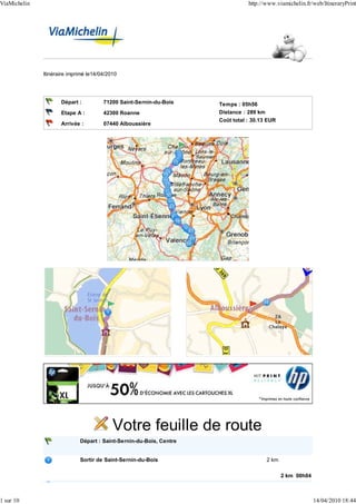
  • 1. ViaMichelin http://www.viamichelin.fr/web/ItineraryPrint Itinéraire imprimé le14/04/2010 Départ : 71200 Saint-Sernin-du-Bois Temps : 05h56 Etape A : 42300 Roanne Distance : 289 km Coût total : 30.13 EUR Arrivée : 07440 Alboussière Votre feuille de route Départ : Saint-Sernin-du-Bois, Centre Sortir de Saint-Sernin-du-Bois 2 km 2 km 00h04 Traverser Les Vernizeaux 0.9 km 1 sur 10 14/04/2010 18:44
  • 2. ViaMichelin http://www.viamichelin.fr/web/ItineraryPrint Traverser Le Creusot 6.5 km Continuer sur : Rue Goujon (0.4 km) Continuer sur : D138 / Route de Saint-Sernin (1.5 km) Succession de virages sur 0.3 km 3.5 km 00h08 Prendre D138 / Rue des Martyrs de la Libération (0.1 km) Au rond-point, Place Charles de Gaulle, prendre la 2nde sortie (0.1 km) Continuer sur : D984 / Avenue François Mitterrand Au rond-point, prendre la 3ème sortie Continuer sur : Allée (0.9 km) Jean Perrin Prendre Allée Gustave Eiffel (0.6 km) Prendre à droite : Boulevard de l'Industrie (0.2 km) Prendre à gauche : Rue Baptiste Marcet (0.2 km) Prendre à gauche : Rue des Acacias (0.3 km) Prendre à gauche : D28 / Rue Albert 1er (0.6 km) Continuer sur : D28 (1.5 km) Sortie de Le Creusot 9.5 km 00h24 D28 Continuer sur : D28 0.4 km 9.5 km 00h24 Traverser Torcy 3 km Continuer sur : D28 (0.7 km) Au rond-point, prendre la 1ère sortie Continuer sur : N80 (0.7 km) Prendre à gauche : Route du Centre (0.6 km) Virage à droite 11 km 00h26 Continuer sur : Route du Centre (0.8 km) Sortie de Torcy 13 km 00h28 Continuer sur : Route du Centre 2.5 km 15 km 00h31 Au rond-point, prendre la 2nde sortie 4 km 19 km 00h35 Prendre à droite : N70 / E607 en direction de : 3 km N70 MONTCEAU MOULINS E607 BLANZY-CENTRE Prendre sortie en direction de : 21 km 00h37 MONTCEAU-LES ALOUETTES 2 sur 10 14/04/2010 18:44
  • 3. ViaMichelin http://www.viamichelin.fr/web/ItineraryPrint 22 km 00h38 Traverser Blanzy 0.6 km Continuer tout droit (0.4 km) Continuer sur : Avenue du Maréchal Leclerc (0.2 km) Sortie de Blanzy 23 km 00h39 Traverser Montceau-les-Mines 5 km Continuer sur : Avenue du Maréchal Leclerc (1.3 km) Prendre à gauche : D974 / Quai Jules Chagot (1.4 km) Prendre D974 (2 km) Sortie de Montceau-les-Mines 28 km 00h51 D974 Continuer sur : D974 0.8 km Succession de virages sur 0.8 km 28 km 00h51 29 km 00h51 Traverser Saint-Vallier 0.8 km Continuer sur : D974 (0.5 km) Continuer tout droit (<0.1 km) Au rond-point, prendre la 1ère sortie Continuer sur : D235 (0.3 km) Sortie de Saint-Vallier 29 km 00h52 N70 Prendre à gauche : N70 / E607 en direction de : 25 km N70 E607 ROANNE MOULINS VICHY CIRY-LE-NOBLE PARAY-LE-MONIAL Traversée de Ciry-le-Noble 32 km 00h55 55 km 01h12 Continuer sur : N79 / E607 / E62 4 km N79 Prendre sortie en direction de : 59 km 01h14 E607 SAINT YAN VITRY-EN-CHAROLLAIS PARAY-LE-MONIAL-SUD 59 km 01h15 A Vitry-en-Charollais, Au rond-point, prendre la 4ème sortie en direction 0.4 km de : D979 CHALON-SUR-SAÔNE MONTCEAU-LES-MINES SAINT-YAN VITRY-EN-CHAROLLAIS-LE-BOURG PARAY-LE-MONIAL-SUD ZONE INDUSTRIELLE LE MONT 59 km 01h15 D979 Au rond-point, prendre la 3ème sortie Continuer sur : D979 1.1 km 3 sur 10 14/04/2010 18:44
  • 4. ViaMichelin http://www.viamichelin.fr/web/ItineraryPrint 60 km 01h16 Traverser Paray-le-Monial 3 km Continuer sur : D979 (1.4 km) Prendre à droite : D352BIS / Route de Saint-Yan (1.4 km) Sortie de Paray-le-Monial 63 km 01h22 Prendre D352BIS 7.5 km 71 km 01h29 D982 Continuer sur : D982 12 km 83 km 01h39 Tourner à gauche 0.1 km 83 km 01h39 Traverser Marcigny 3.5 km Continuer sur : Rue des Abergeries (1.4 km) Prendre à droite : Rue du Général de Gaulle (0.1 km) Prendre à droite : D989 / Rue du 8 Mai 1945 (<0.1 km) Prendre D989 (0.1 km) Prendre à gauche : Rue de Précy (0.1 km) Prendre à gauche : Rue des Remparts (<0.1 km) Prendre à droite : Rue de Borchamp (1.4 km) Prendre à gauche : D982 (<0.1 km) Sortie de Marcigny 86 km 01h45 D982 Continuer sur : D982 9.5 km RADAR : D982 borne km 29.3 (90 km/h), au niveau de Saint- 89 km 01h47 Martin-du-Lac. 96 km 01h54 D482 Continuer sur : D482 15 km Traversée de Briennon 96 km 01h54 RADAR : D482 borne km 6.4 (50 km/h), au niveau de Pouilly- 101 km 02h00 sous-Charlieu. 111 km 02h10 Entrer dans Roanne 4 km Continuer sur : Rue de Charlieu (3.5 km) Continuer sur : Avenue de Lyon (0.1 km) Prendre à gauche : Rue Alexandre Roche (0.2 km) Prendre Place Georges Clemenceau (<0.1 km) Continuer sur : Place du Maréchal de Lattre de Tassigny (0.1 km) Continuer sur : Rue du Château (<0.1 km) Prendre à gauche : Rue des Aqueducs (0.1 km) Prendre à gauche : Rue de Cadore (0.1 km) 115 km 02h20 4 sur 10 14/04/2010 18:44
  • 5. ViaMichelin http://www.viamichelin.fr/web/ItineraryPrint Etape A : Roanne, Centre 115 km 02h20 Sortir de Roanne 1.3 km Prendre Rue Roger Salengro (0.5 km) Prendre à droite : Avenue de Lyon (0.4 km) Au rond-point, prendre la 3ème sortie Continuer sur : D504 (0.5 km) Sortie de Roanne 116 km 02h24 A Le Coteau, Prendre Avenue de la Libération 3 km 119 km 02h28 D207 Prendre D207 4 km Traversée de Parigny 120 km 02h29 123 km 02h33 Traverser L'Hôpital-sur-Rhins 0.9 km Continuer sur : D207 (0.7 km) Prendre D907 (0.2 km) Sortie de L'Hôpital-sur-Rhins 124 km 02h34 D907 Continuer sur : D907 0.7 km Virage à droite 125 km 02h35 125 km 02h35 Au rond-point, prendre la 2nde sortie Continuer sur : N82 en direction de : 16 km N82 N82 A72 SAINT-ETIENNE CLERMONT-FERRAND NEULISE Virage à droite 138 km 02h44 141 km 02h46 D1082 Continuer sur : D1082 en direction de : 4 km BALBIGNY FEURS Traversée de Balbigny 143 km 02h47 145 km 02h51 Continuer tout droit <0.1 km 145 km 02h51 D1082 Au rond-point, prendre la 2nde sortie Continuer sur : D1082 en direction 7.5 km de : N82 SAINT-ETIENNE FEURS Traversée de Épercieux-Saint-Paul 147 km 02h53 5 sur 10 14/04/2010 18:44
  • 6. ViaMichelin http://www.viamichelin.fr/web/ItineraryPrint 152 km 02h58 A Feurs, Prendre à gauche : Rue du 8 Mai 0.5 km 153 km 02h58 D89 Prendre à droite : D89 / Place du Forum 0.1 km 153 km 02h59 Continuer tout droit <0.1 km 153 km 02h59 Au rond-point, prendre la 2nde sortie Continuer sur : Rue Philibert 0.2 km Mottin en direction de : LYON PANISSIÈRES L'ARBRESLE 153 km 02h59 Prendre à droite : Rue de Verdun en direction de : 1 km SAINT-ETIENNE 154 km 03h01 D1082 Prendre D1082 / Route de Saint-Etienne 0.6 km 155 km 03h01 Continuer tout droit <0.1 km 155 km 03h01 D1082 Au rond-point, prendre la 2nde sortie Continuer sur : D1082 / Route de 0.5 km Saint-Etienne en direction de : N82 SAINT-ETIENNE LYON MONTROND-LES-BAINS 155 km 03h02 Continuer tout droit <0.1 km 155 km 03h02 D1082 Au rond-point, prendre la 2nde sortie Continuer sur : D1082 en direction 20 km de : N82 SAINT-ETIENNE LYON MONTROND-LES-BAINS Traversée de Montrond-les-Bains 163 km 03h08 RADAR : N82 borne km 45.5 (90 km/h), au niveau de Cuzieu. 170 km 03h17 175 km 03h23 A Veauche, Continuer tout droit <0.1 km 175 km 03h23 D1082 Au rond-point, prendre la 2nde sortie Continuer sur : D1082 en direction 1.8 km de : N82 A72 6 sur 10 14/04/2010 18:44
  • 7. ViaMichelin http://www.viamichelin.fr/web/ItineraryPrint SAINT-ETIENNE ANDRÉZIEUX-BOUTHÉON BOUTHÉON LA FOUILLOUSE Traversée de Andrézieux-Bouthéon 176 km 03h24 177 km 03h25 Continuer tout droit 0.1 km 177 km 03h25 D1082 Au rond-point, prendre la 3ème sortie Continuer sur : D1082 / Avenue 0.7 km Jean Mermoz en direction de : LA FOUILLOUSE BOUTHÉON ZONE INDUSTRIELLE LA PLAINE SERVICE DES MINES 178 km 03h26 Continuer tout droit <0.1 km 178 km 03h26 D1082 Au rond-point, prendre la 2nde sortie Continuer sur : D1082 0.8 km Virage à droite 179 km 03h27 179 km 03h27 Continuer tout droit <0.1 km 179 km 03h27 D1082 Au rond-point, prendre la 3ème sortie Continuer sur : D1082 en direction 2 km de : D1082 SAINT-ETIENNE LA FOUILLOUSE Traversée de La Fouillouse 180 km 03h28 181 km 03h29 Continuer tout droit <0.1 km 181 km 03h30 D1082 Au rond-point, prendre la 2nde sortie Continuer sur : D1082 en direction 5.5 km de : LA FOUILLOUSE SAINT-ETIENNE 187 km 03h35 Traverser Saint-Priest-en-Jarez 2 km Prendre Avenue Pierre Mendès France (1.9 km) Tourner à droite (0.1 km) Sortie de Saint-Priest-en-Jarez 189 km 03h39 Continuer tout droit <0.1 km 189 km 03h39 A Saint-Étienne, Prendre Avenue de Verdun 0.5 km 7 sur 10 14/04/2010 18:44
  • 8. ViaMichelin http://www.viamichelin.fr/web/ItineraryPrint 189 km 03h40 Continuer sur : Rue Bergson 1 km 190 km 03h42 Continuer sur : Boulevard du Lieutenant Maurice Knoblauch 0.2 km 190 km 03h43 Continuer sur : Place du Maréchal Foch 0.1 km 190 km 03h43 Prendre à droite : Boulevard Louis Lumière 0.1 km 190 km 03h44 Prendre à gauche : Boulevard Albert Ier 0.4 km 191 km 03h45 Continuer sur : Boulevard Augustin Thierry 0.1 km 191 km 03h45 Prendre à gauche : Boulevard Alfred de Musset 0.6 km 192 km 03h47 Prendre Boulevard Frédo Krumnow 0.2 km 192 km 03h47 Prendre Boulevard Pierre Mendès France 0.7 km 193 km 03h49 Prendre Boulevard Martin Bernard 0.8 km 193 km 03h52 Prendre Boulevard Robert Maurice <0.1 km 193 km 03h52 Prendre Boulevard Joseph Béthenod 0.3 km 194 km 03h53 Continuer sur : Boulevard Daguerre 0.4 km 194 km 03h54 Prendre à gauche : Rue Rémy Doutre <0.1 km 194 km 03h54 D88 Prendre à droite : D88 1.1 km 195 km 03h57 Prendre à gauche : Boulevard Pasteur 0.3 km 196 km 03h58 D1082 Prendre à droite : D1082 / Rue Robespierre 0.4 km 196 km 03h59 Continuer tout droit <0.1 km 8 sur 10 14/04/2010 18:44
  • 9. ViaMichelin http://www.viamichelin.fr/web/ItineraryPrint 196 km 03h59 D1082 Au rond-point, prendre la 2nde sortie Continuer sur : D1082 en direction de : 31 km N82 ANNONAY PLANFOY SAINT-GENEST-MALIFAUX BOURG-ARGENTAL Succession de virages sur 3.5 km 197 km 04h01 Traversée de Planfoy 201 km 04h05 Succession de virages sur 0.6 km 203 km 04h07 Succession de virages sur 0.3 km 207 km 04h11 Succession de virages sur 0.5 km 210 km 04h13 Succession de virages sur 3.5 km 211 km 04h15 Descente dangereuse sur 7.5 km 213 km 04h17 RADAR : D1082 borne km 92.5 (90 km/h), au niveau de La 216 km 04h19 Versanne. Succession de virages sur 3.5 km 216 km 04h19 Vous roulez depuis environ 2 heures, pensez à faire une pause. Succession de virages sur 1.6 km 223 km 04h29 Descente dangereuse sur 0.8 km 226 km 04h31 227 km 04h32 D820 Continuer sur : D820 3 km Traversée de Saint-Marcel-lès-Annonay 228 km 04h33 230 km 04h35 D206 Prendre à droite : D206 en direction de : 3 km D206 ANNONAY Succession de virages sur 1.2 km 231 km 04h36 233 km 04h38 Traverser Annonay 5.5 km Continuer sur : D206 (1.2 km) Au rond-point, Avenue Jean Jaurès, prendre la 3ème sortie (0.6 km) Continuer sur : D206A / Avenue de Backnang Continuer sur : D206A / Viaduc Daniel Aimé (<0.1 km) Au rond-point, Rue du Québec, prendre la 1ère sortie (0.1 km) Continuer sur : D370 / Rue du Québec Continuer sur : D370 (3 km) Sortie de Annonay 238 km 04h49 D370 Continuer sur : D370 5.5 km Virage à droite 238 km 04h49 243 km 04h55 Traverser Talencieux 1.5 km 9 sur 10 14/04/2010 18:44
  • 10. ViaMichelin http://www.viamichelin.fr/web/ItineraryPrint Continuer sur : D370 (1.2 km) Prendre à gauche : D370B (0.3 km) Sortie de Talencieux 245 km 04h58 D370B Prendre D370B 3 km Succession de virages sur 2.5 km 245 km 04h58 Descente dangereuse sur 2.5 km 245 km 04h58 248 km 05h02 A Cance, continuer 0.2 km Continuer sur : D370B (<0.1 km) Prendre à droite : D86 (0.1 km) 248 km 05h02 D86 Prendre D86 16 km Succession de virages sur 0.2 km 251 km 05h06 Succession de virages 253 km 05h08 264 km 05h21 Traverser Tournon-sur-Rhône 4 km Continuer sur : D86 (1.6 km) Prendre à droite : D219 / Place Stéphane Mallarmé (<0.1 km) Prendre D219 (1.6 km) Au rond-point, prendre la 2nde sortie Continuer sur : D86 / (0.8 km) Avenue de Nîmes Sortie de Tournon-sur-Rhône 268 km 05h30 D86 Continuer sur : D86 0.5 km Succession de virages sur 20 km 268 km 05h30 269 km 05h31 A Mauves, continuer 0.2 km Prendre D386 (<0.1 km) Prendre à droite : D219 (0.2 km) 269 km 05h31 D219 Prendre D219 20 km 289 km 05h56 Entrer dans Alboussière 0.2 km 289 km 05h56 Arrivée : Alboussière, Centre 289 km 05h56 10 sur 10 14/04/2010 18:44