More Related Content
Similar to Summary of a remote sensing experiment
Similar to Summary of a remote sensing experiment (20)
Summary of a remote sensing experiment
- 1. Geomatica® in Action!
A comparison of atmospheric correction
methods for temporal change analysis
using Landsat data
Chris Czerwinski - Graduate Student, Carleton University, Ottawa, Canada
Scope:
This project was intended to compare a number of atmospheric correction
methods for the purpose of developing an inter-annual time-series of
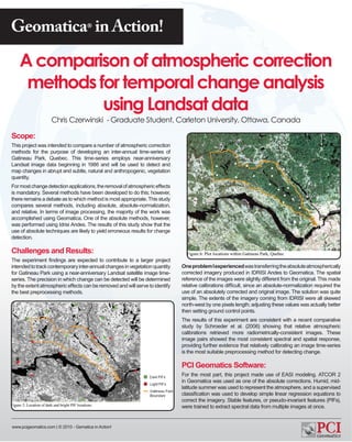
Gatineau Park, Quebec. This time-series employs near-anniversary
Landsat image data beginning in 1986 and will be used to detect and
map changes in abrupt and subtle, natural and anthropogenic, vegetation
quantity.
For most change detection applications, the removal of atmospheric effects
is mandatory. Several methods have been developed to do this; however,
there remains a debate as to which method is most appropriate. This study
compares several methods, including absolute, absolute-normalization,
and relative. In terms of image processing, the majority of the work was
accomplished using Geomatica. One of the absolute methods, however,
was performed using Idrisi Andes. The results of this study show that the
use of absolute techniques are likely to yield erroneous results for change
detection.
Challenges and Results:
The experiment findings are expected to contribute to a larger project
intended to track contemporary inter-annual changes in vegetation quantity One problem I experienced was transferring the absolute atmospherically
for Gatineau Park using a near-anniversary Landsat satellite image time- corrected imagery produced in IDRISI Andes to Geomatica. The spatial
series. The precision in which change can be detected will be determined reference of the images were slightly different from the original. This made
by the extent atmospheric effects can be removed and will serve to identify relative calibrations difficult, since an absolute-normalization required the
the best preprocessing methods. use of an absolutely corrected and original image. The solution was quite
simple. The extents of the imagery coming from IDRISI were all skewed
north-west by one pixels length; adjusting these values was actually better
then setting ground control points.
The results of this experiment are consistent with a recent comparative
study by Schroeder et al. (2006) showing that relative atmospheric
calibrations retrieved more radiometrically-consistent images. These
image pairs showed the most consistent spectral and spatial response,
providing further evidence that relatively calibrating an image time-series
is the most suitable preprocessing method for detecting change.
PCI Geomatics Software:
For the most part, this project made use of EASI modeling. ATCOR 2
in Geomatica was used as one of the absolute corrections. Humid, mid-
latitude summer was used to represent the atmosphere, and a supervised
classification was used to develop simple linear regression equations to
correct the imagery. Stable features, or pseudo-invariant features (PIFs),
were trained to extract spectral data from multiple images at once.
www.pcigeomatics.com | © 2010 - Gematica in Action!