Introduction to Basketball-PowerPoint Presentation
Training route 9
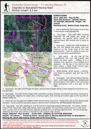
1. Kokoda Challenge - Training Route 9
Clagiraba to Beaudesert-Nerang Road
Section Length: 5.5 km
DIRECTIONS
Start UBD Ref: Map 35-N9
Start GPS Position: (AGD66 datum)
56 526205E 6901870N Height: 90
metres
Starting Point: Belliss Road, Clagiraba
1. Follow Belliss Rd 300 metres north to the
T-intersection with Clagiraba Rd.
2. Turn here: Turn right after crossing
Clagiraba Rd and follow the verge of
Clagiraba Rd gently uphill (east) for
approximately 300 metres until it starts to
steepen.
3. Turn here: Locate the rough footpad on
the left just before the power pole and
continue up the rough edge of the road
embankment. There is a gate to cross just
after the start of this embankment.
4. Turn here: At the top of the
embankment hill, turn left (north) and
follow the track uphill. Initially, it is a
footpad, then becomes more eroded as it
steepens. At the top of the first hill, the
track passes a Gold Coast Council sign,
before a short downhill section.
5. After another uphill section, a barbed-
wire fence is reached near the top of Mt
Nathan.
6. Turn here: Turn left and follow the foot
track north-west along the barbed-wire
fence for about 150 metres, then arrive at a
track intersection with a wire gate on the
right.
7. Turn here: Go right and through the gate, and proceed straight ahead a short distance towards the two
mango trees.
8. Turn here: Turn left at the mango trees and follow a grassy laneway (sometimes becomes overgrown)
north along the ridgeline for about 1km, crossing a gate, then arriving at another gate at the top end of
Nathan Valley Rd.
9. Continue over the gate onto Nathan Valley Rd and follow it downhill. Please take care on the narrow road
shoulder. Continue all the way down (about 1.8km) to the T-intersection with Beaudesert-Nerang Rd.
10. Turn here: Turn left, heading in a north direction beside Beaudesert-Nerang Rd. For safety, please
keep off the road itself. After 700 metres, finish just before The Oval Drive where there is a clear area
near a power pole on the left, directly opposite a gated entry to Nerang National Park. On the Challenge
weekend, this clear area will be a checkpoint with support crew access.
Finish UBD Ref: Map 26-B16 Finish GPS: (AGD66) 56 527470E 6905185N
Height: 70 metres Finishing Point: Access gate to Nerang National Park on Beaudesert-
Nerang Rd, about 200 metres south-east of The Oval Drive.
The Kokoda Challenge values the natural environment and aims for all our activities to have a minimal
impact. Please ensure you practise minimal impact bushwalking doing nothing and leaving nothing that
shows where you have been.
This map and directions are kindly provided by the Gold Coast Bushwalkers Club and are
accurate only at the time of writing. Thankyou.