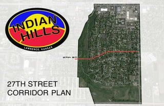
27th St. Corridor Plan Promotes Safety and Sustainability
•
0 likes•252 views

This document provides a 3-phase plan to implement traffic calming measures along 27th Street in the Indian Hills neighborhood of Lawrence, Kansas. Phase 1 involves striping the road to create the impression of a narrower street. Phase 2 addresses high-accident intersections through devices like traffic circles, a raised crosswalk, and a roundabout. Phase 3 focuses on education and enhancement with signs, neighborhood speed watch, and public art to sustain calm traffic long-term. The overall goal is to create a safe, sustainable corridor for all users in accordance with the community's vision and sustainability goals.

Recommended
Recommended
More Related Content
Similar to 27th St. Corridor Plan Promotes Safety and Sustainability
Similar to 27th St. Corridor Plan Promotes Safety and Sustainability (20)
27th St. Corridor Plan Promotes Safety and Sustainability
- 2. Lawrence, Kansas Indian Hills 27th St. Corridor Plan 2 This page is intentionally left blank
- 3. Indian Hills 27th St. Corridor Plan Lawrence, Kansas 3 TABLE OF CONTENTS Section 1: Introduction.................................................. Executive Summary.............................................. Community Input................................................... Activity Since 2013............................................... Moving Forward.................................................... Section 2: Sustainability Goals........................................ Vision Statement ................................................. Sustainability and the 3 E’s.................................. Section 3: Corridor Action Plan..................................... Vicinity Map.......................................................... Exisiting Conditions............................................... Project Overview................................................... Phase 1................................................................ Phase 2................................................................ Phase 3................................................................ Section 4: Implementation............................................. Section 5: Appendix...................................................... 27th Graphics....................................................... Harvard Rd. Study................................................ Resources and Citations............................................... Created By: Trey Maevers December 19, 2014 5 6 7 8 9 11 12 13 15 16 17 18 19 20-24 25 27 31 32-33 34-35 37
- 4. Lawrence, Kansas Indian Hills 27th St. Corridor Plan 4 This page is intentionally left blank
- 5. Indian Hills 27th St. Corridor Plan Lawrence, Kansas 5 Section 1: Introduction
- 6. Lawrence, Kansas Indian Hills 27th St. Corridor Plan 6 Section 1: Introduction EXECUTIVE SUMMARY The Indian Hills 27th St. Corridor Plan is intended to continue the vision of 27th St. as a sustainable, safe community road. For this vision to become real, the public needs to continue and complete the planning process by deciding on final traffic-calming plans to be presented to the City of Lawrence. This Corridor Plan initiates the discussion on the engineering, enhancement, education and enforcement techniques for traffic calming along 27th street in the Indian Hills Neighborhood in Lawrence, KS. 27th street is a collector road that connects the Indian Hills residential area to Louisiana and Iowa streets which are minor and major arterials, respectively. Furthermore, this Plan will recommend some traffic devices and how their function, form and use for volume and speed management will benefit the community. This Plan will also be integral in maintaining safety for drivers, pedestrians, bicyclists and motorists along this stretch of road. This Plan considered multiple studies that were performed by the ITE for traffic calming on collector streets. ITE is the international educational and scientific association of transportation engineers who are responsible for meeting mobility and safety needs (ITE.org). The Institute of Transportation Engineers (ITE) defines traffic calming as “the combination of mainly physical measures that accomplish the goal to reduce the negative effects of motor vehicle use, alter driver behavior and improve conditions for non-motorized street users” (Lockwood, 1997). Many organizations and governments facilitate traffic calming with the three “E’s”, engineering, education and enforcement. The main objective of traffic calming is not solely creating stopping actions, but steady, moderate, predictable, and safe speeds. With the combination of these 3 E’s and the Goals set forth in this Plan, the community and the City of Lawrence can develop the best Course of Action to develop a safe and sustainable 27th Street in the Indian Hills Neighborhood. Source: openstreetsmap.org Source: GoogleEarth
- 7. Indian Hills 27th St. Corridor Plan Lawrence, Kansas 7Section 1: Introduction COMMUNITY INPUT In 2013 the Indian Hills Neighborhood Association (INHA) created a Neighborhood Plan. In this Plan, the neighborhood residents were asked to rate the neighborhood facilities and services on a scale of 1 to 5, 1 being “poor” and 5 “excellent”. The result for "Traffic Controls" was 2.74 or "Fair". This demonstrates that traffic control is not rated as an outstanding service. It is quite the contrary as it rated the third lowest in this survey. Section 3.1 of the Plan outlines the “top 20 list” for the vision of the neighborhood and the traffic speed and noise along 27th St. is a principal issue to be addressed. This was a result of multiple negative comments for traffic control in general and issues specific to 27th St. Section 4.1.C of the Plan outlines five strategies to mitigate this issue. Another portion of the input gave an opportunity for residents to voice their opinion on many items, including traffic control. On this lists, there is an apparent trend of heavy volumeand speed on 27th, sometimes late at night which brings unwanted noise. Also, another common theme is the intersection of 27th St. and Louisiana which denotes that this intersection should be a high priority in any future plans. Source: IHNA Neighborhood Plan, 2013
- 8. Lawrence, Kansas Indian Hills 27th St. Corridor Plan 8 Section 1: Introduction ACTIVITY SINCE PLAN IN 2013? After all of the community input in the Neighborhood Plan, 27th St. traffic calming was addressed by the City of Lawence. The City conducted a preliminary study to see if 27th St. met the criteria per the the Traffic Calming Policy. This study had to determine if 27th St. met any one of the following conditions: the 85th percentile speed of traffic is 5 mph or greater over the speed limit, or the 24-hour two-way traffic volume is greater than 3,000, or cut-through traffic comprises more than 50% of the traffic during the peak hour of the day, or more than 50% of the frontage of the roadway consists of residential lots with the houses facing the roadway in question, or where no single condition is satisfied, but where any two of A, B, C or D above are satisfied to the extent of 80 percent or more of the stated values. (City of Lawrence, 2014) It was determined that the speed and volume criteria were met (See Appendix “C” and “D”). After the study, the issue came before the City and later approved by Lawrence’s Traffic Safety Commission on December 23, 2012 and the City Commission on January 22, 2013. The 27th St. traffic calming project was put on a compiled list of other streets to be ranked for receiving traffic calming devices. Lawrence’s Traffic Calming Project Priority Ranking System was adopted along with the Traffic Calming Policy on August 23, 2005. After the initial submission for traffic calming measures, 27th St. was within the top ten streets to receive funding for the implementation of traffic devices. During late 2013 and early 2014, 27th St. was declared at the top of the list. Source: lawrenceks.org/public_works/traffic
- 9. Indian Hills 27th St. Corridor Plan Lawrence, Kansas 9Section 1: Introduction MOVING FOWARD The Traffic Calming Policy states, “After a project is approved and funded by the City Commission, traffic calming devices will only be constructed at a location if 70% or more of the property owners within 300 feet measured along the centerline of the street in each direction approve of the installation or if directed by the City Commission. The individual, group or neighborhood making the request shall be responsible for obtaining the property owners’ and residents’ approval in writing and submitting it to the city.” This is important to keep in mind when the decision is made of which devices are being used and where they are being installed. The Traffic Engineering Department will suggest the device based on a traffic study and the expert knowledge of all the aforementioned devices and techniques in this review. Traffic Engineering will not rely on pre-set community approval ratings, but rather will strive to help the impacted community reach general agreement on the nature of the problem and the proposed solution. This Corridor Plan is a document that will help the Community and theCitytoprogressfromthe“Planning”stagetothe“Decision-Making”stage. 27th St. Corridor Action Plan Source: lawrenceks.org/public_works/traffic
- 10. Lawrence, Kansas Indian Hills 27th St. Corridor Plan 10 This page is intentionally left blank
- 11. Indian Hills 27th St. Corridor Plan Lawrence, Kansas 11 Section 2: Sustainability Goals
- 12. Lawrence, Kansas Indian Hills 27th St. Corridor Plan 12 Section 3: Sustainability Goals VISION STATEMENT We, the residents of Indian Hills envision 27th St to be a street: •Where people feel safe and comfortable walking, riding a bicycle, driving a vehicle and where the street is a pleasant public place; •That exempli ies responsible neighborhood steward ship that results in an enjoyable street for all; •That preserves qualities that people value most about living in a neighborhood for families and to raise those families in a clean, attractive community with ageless appeal. This vision exemplifies the importance of healthy neighborhood action and the value of safety and a high quality of life. This vision is the guide for this Plan to enhance the quality of the neighborhood as a place to live, work and play through the actions taken on 27th St. The core goal is to have a safe, attractive and sustainable 27th St. corridor in the Indian Hills community that is meaningful over the long-term for neighbors and travelers. Sustainability is the overarching goal for this Plan and it is considered to be at the intersection of these Core Values: Equity, Economy, and Environment. Equity in this context is the state of complete physical, mental and social well-being of residents and people who enjoy this community. A key theme is the degree to which the neighborhood provides for all groups- young and old, rich and poor. The ecological footprint of cities worldwide has increased and continues to grow, so it is up to local neighborhoods to advocate responsibility for the health of the global climate and ecosystem. Finally, local neighborhoodsshouldsee this corridor as an economic opportunity . The revitalization as a healthy and sustainable neighborhood can only be achieved if there is a local will and energy. Part of that energy comes form the vitality of the local economy, investing in people and places, as well as effective partnerships between community, voluntary, public and private sector organizations.
- 13. Indian Hills 27th St. Corridor Plan Lawrence, Kansas Section 3: Sustainability Goals 13 SUSTAINABILITY AND THE 3E’s ECONOMY ENVIRONMENT EQUITY ENGINEERING EDUCATION ENFORCEMENT Below are the sustainable goals and how the 3 E’s of traffic calming can facilitate the success of the 27th Street Corridor Plan. They provide short and long-term visions and serve as the foundation of the plan. Require appropriate and attractive design standards for traffic calming devices which will increase property values throughout the neighborhood. Explore and recruit volunteers in the community and other organizations to help with less intensive work to reduce costs and increase the speed of project delivery. Use this opportunity to educate the volunteers about the value of safe and sustainable roads for the community. Explore enforcement-type financing options to facilitate the funding for the project (e.g. vehicle mileage road user fees, user fees, fuel taxes, etc.) Plant street trees, shrubs and open space to help enforce slower traffic speeds. Work closely with the Police Department to ensure all traffic laws are enforced and propose an increased awareness of crashes in the area. Promote and market the importance of environmentally-friendly elements in the devices (e.g. the use of bioswales and rain gardens to enhance stormwater quality) Collaborate with the Safe Routes to School Program at Broken Arrow Elementary School about the changes along 27th St. Also, promote safety to the driver’s along 27th St. with the use of creative, community-centered signage. Implement the concept of a complete, functional and interconnected public alternative transportation network that is accessible for all people of all abilities, including equal considerations for the disabled and elderly. Design traffic calming devices considering environmental impacts including but not limited to, storm-water drainage, underground utilities, sanitation and other features that impact the ecological system.
- 14. Lawrence, Kansas Indian Hills 27th St. Corridor Plan 14 This page is intentionally left blank
- 15. Indian Hills 27th St. Corridor Plan Lawrence, Kansas 15 Section 3: Corridor Action Plan
- 16. Lawrence, Kansas Indian Hills 27th St. Corridor Plan 16 Section 3: Corridor Action Plan
- 17. Indian Hills 27th St. Corridor Plan Lawrence, Kansas 17Section 3: Corridor Action Plan EXISTING CONDITIONS Problem areas by Priority according to IHNA Neighborhood Plan: 27th St. and Louisiana Intersection: This intersection is infamous for automobile accidents of cars pulling onto Louisiana from 27th St, see Appendix “A” of a diagram from the Lawrence Police Department. Naismith Trail Crossing: Naismith Park/Creek runs along the western edge of Indian Hills. There is a bike/pedestrian trail that runs throughout the park and crosses 27th St on the western edge of the corridor study area. Currently, there is a marked crosswalk cutting across 27th through existing curb-cuts. This is a highly-dangerous crossing for this trail. 27th St. and Missouri Intersection: The unique, oval shape and location of this intersection creates a dangerous situation for all. This intersection's shape contributes to strange traffic maneuvers and behaviors. 27th St. and Alabama Intersection: A traditional 4-way stop, but with the amount of traffic along both roads this intersection becomes cumbersome to get through, especially during high-volume hours. 1 2 3 4 1 2 3 4
- 18. Lawrence, Kansas Indian Hills 27th St. Corridor Plan 18 Section 3: Corridor Action Plan PROJECT OVERVIEW This Plan's recommendation is divided into three (3) phases. The first phase focuses on installing a device that is quick and doesn’t interrupt the following phases. The second phase addresses the obvious problem areas. Lastly, the third phase will focus on the sustainment of traffic calming along this portion of 27th St. PHASE 1: In current economic times and local budgets, the most economical way is the best way. The first suggestion to address speeding is to consider traffic-calming striping. Striping is a viable, low-cost alternative to traditional traffic calming techniques. PHASE 2: The second phase addresses the main problem areas along this portion of 27th St. and without interrupting the intention of the bike-lane striping. The second phase consists of traffic circles in the intersections of Missouri and Alabama streets, a raised crosswalk for the Naismith Trail crossing and roundabout at the intersection of Louisiana and 27th St. This intersection is infamous for automobile accidents of cars pulling onto Louisiana from 27th St, see Appendix “A” of a diagram from the Lawrence Police Department. These methods have proven successful on another project similar to 27th St. (See Appendix “E” for the Harvard Rd. traffic calming project) PHASE 3: The third phase will consist more of the education and enhancement features. This will effectively help with sustaining calm traffic along this portion of 27th. This method consist of signs to promote the community, neighborhood speed watch and public art on the road. *All average costs and speed reductions: See Appendix “F” Phase 1: Striping/Bike Lanes Phase 2: Engineering devices Phase 3: Signs, Public Art, Neighborhood Speed Watch Source: giacalonephotos.files.wordpress.com Source: humpal.org Source: 3.bp.blogspot.com Source: alexandriava.gov Source: vral.com
- 19. Indian Hills 27th St. Corridor Plan Lawrence, Kansas 19Section 3: Corridor Action Plan PHASE 1: Striping/Bike Lane 27th St. from Iowa to Louisiania The best application for striping is when there is a long, wide residential street where speeding is a problem. It works by creating an impression of a narrow roadway. •Pros: may reduce speeds; may increase pedestrian and bicyclist safety; less costly option to install; easy to implement and change if required in the future; •Cons: relies on self-enforcing behavior; some limitations in speed reduction; less effective when speeds are already low. Average Speed Reduction: 1-7mph Average Costs: $500-$1,000 per 500 feet 27th St. lacks any striping, including middle dividers. The simply act of striping not only will increases safety by providing lines for drivers, but this will give more room for cyclists and a buffer for pedestrians. The new striping will be for this whole stretch of 27th St. Before After
- 20. Lawrence, Kansas Indian Hills 27th St. Corridor Plan 20 Section 3: Corridor Action Plan The installation of a raised crosswalk will drastically improve this crossing for the safety of anybody enjoying the trail. This area also has potential to become a central point for park-goers to rest and relax while on the trail. Pros: Moderate costs considerations; effective at slowing vehicles; easy for pedestrians and bicyclists to navigate; and can cause some diversion of excess traffic volumes Cons: improper driving can cause vehicle damage; difficult to remove; can impede large vehicles including emergency vehicles; and may have questionable aesthetics. Average Speed Reduction: 6-8mph Average Costs: $2,500 Before After PHASE 2: Engineering Measures Naismith Raised Crosswalk and Signage
- 21. Indian Hills 27th St. Corridor Plan Lawrence, Kansas 21Section 3: Corridor Action Plan This is a prime place to apply a traffic circle, due to many factors meeting traffic circle criteria: •Location with a history of accidents; •Intersection where queues need to be minimized; •Intersection with irregular geometry; •Place where lower cost traffic control is desired Pros: reduces speeds up to 4-6mph; improves safety; improves aesthetics; can calm two streets at once; minimizes traffic stacking; breaks up sight lines on long roadways Cons: can be more difficult for large vehicles to navigate, especially emergency vehicles; requires greater amount of right-of-way; must be maintained; costly to implement; may affect pedestrians and bicyclists; and can confuse drivers Average Speed Reduction: 4-6 mph Average Costs: $10-000-$50,000 Before After PHASE 2: Engineering Measures 27th/Missouri Traffic Circle and Curb Extension
- 22. Lawrence, Kansas Indian Hills 27th St. Corridor Plan 22 Section 3: Corridor Action Plan Pros: Moderate costs considerations; effective at slowing vehicles; easy for pedestrians and bicycles to navigate; and can cause some diversion of excess traffic volumes Cons: improper driving can cause vehicle damage; difficult to remove; can impede large vehicles including emergency vehicles; and may have questionable aesthetics. Average Speed Reduction: 6-8mph Average Costs: $2,500 Sidewalks on both sides of 27th is a high priority. Lawrence’s Comprehensive Plan (Horizon 2020) instructs the City to, “Provide sidewalks on one side of local street/roads (public and private) and both sides of collector and arterial street/roads.” (Horizon 2020, 5-31, Policy 4.7) Before After PHASE 2: Engineering Measures Raised Crosswalk and Sidewalks The installation of a raised crosswalk at this location will again slow traffic down before and after Louisiana. This location is important for pedestrians due to the close vicinity of Broken Arrow Elementary School.
- 23. Indian Hills 27th St. Corridor Plan Lawrence, Kansas 23Section 3: Corridor Action Plan The importance of this roundabout is not just about the community’s complaints about traffic on and off of Louisiana, but this will actually help the flow of traffic for Broken Arrow during peak hours, when cars get backed up from dropping and picking up kids at school. This roundabout will also compliment the existing tunnel and crossing guards. •Pros: Improves safety; improves aesthetics; can calm two streets at once; minimizes traffic stacking; breaks up sight lines on long roadways •Cons: can be more difficult for large vehicles to navigate, especially emergency vehicles; require greater amount of right-of-way; must be maintained; costly to implement; may affect pedestrians and bicyclists; and can confuse drivers. Average Speed Reduction: 4-6mph Average Costs: 20,000-100,000+ (depends on right- of-way costs, development fees, etc.) Before After PHASE 2: Engineering Measures 27th/Louisiana Roundabout
- 24. Lawrence, Kansas Indian Hills 27th St. Corridor Plan 24 Section 3: Corridor Action Plan In recent years it has become increasingly clear that effective traffic calming must also incorporate enhancement of the streetscape. This includes design and landscaping features that not only improve the aesthetics and livability of a neighborhood but increase the effectiveness of many of the previous engineering devices. This is accomplished by creating visual breaks in the streetscape and reducing the “raceway” appearance of wide, residential streets. (Congress for New Urbanism, 2014) Enhancements can include planting shrubs or trees along the roadway, installing public art or banners, constructing decorative pavement markers or materials, installing lighting, introducing or altering on-street parking, etc. A low-cost and quick approach is to use the eight (8) telephone poles (located below) and attaching a pre-determined Neighborhood banners. This will create a visual cue that drivers are entering in a neighborhood. Neighborhood Signs Community Street Art PHASE 3: Signs and Community Art Multiple locations Source: streetfilms.org
- 25. Indian Hills 27th St. Corridor Plan Lawrence, Kansas 25 PHASE 3: Neighborhood Speed Watch Multiple locations Targeted police enforcement in areas where traffic volumes are great, where speeds are high, where the probability for serious accidents is present, or where complaints have been made can lead to dramatic, but often short-term reductions in speeds or volumes. In response some communities implemented a speed watch program that would lend residents radar guns and have them record the speeds, makes, models, and license plate numbers of all vehicles clocked speeding through their neighborhood. The police department then sends warning letters to the owners of offending vehicles, reminding them of the posted speed limit and the neighborhood’s concern for safety. (Ewing, 1999,117) The best application for this is when residents’ interest is high and they are willing to take time and energy to follow the procedures given to them by local law enforcement. •Pros: low cost; easy to manage and perform the activity; better relationship with local law enforcement agencies; opportunity to education kids about safe driving and why there is a need for traffic calming •Cons: time-consuming activity; lack of volunteers during hours when speeding is at its worst; lack of resident interest Average Costs: Varies among rates and duration of usage for radar and other signage and/or equipment used. Source: informationliberation.com Source: http://mytowncrier.ca/
- 26. Lawrence, Kansas Indian Hills 27th St. Corridor Plan 26 This page is intentionally left blank
- 27. Indian Hills 27th St. Corridor Plan Lawrence, Kansas 27 Section 4: Implementation
- 28. Lawrence, Kansas Indian Hills 27th St. Corridor Plan 28 This page is intentionally left blank
- 29. Indian Hills 27th St. Corridor Plan Lawrence, Kansas 29Section 4: Implementation IMPLEMENTATION The Traffic Calming Policy states, “After a project is approved and funded by the City Commission, traffic calming devices will only be constructed at a location if 70% or more of the property owners within 300 feet measured along the centerline of the street in each direction approve of the installation or if directed by the City Commission. The individual, group or neighborhood making the request shall be responsible for obtaining the property owners’ and residents’ approval in writing and submitting it to the city.” This is important to keep in mind when the decision is made of which devices are being suggested and where. The Traffic Engineering Department will suggest the devices based on the traffic study and their expert knowledge of all the aforementioned devices and techniques in this Plan. Ultimately, Traffic Engineering and the City of Lawrence wants the best for the neighborhoods in these scenarios. The Policy allows a partial democratic process with the people directly impacted within the 300 feet. This facilitates the general agreement among neigbhors on the nature of the problem and the proposed solution. If the residents along this corridor agree that: there is a problem; the proposed solutions in this Plan are the most appropriate; and their concerns have been addressed and mitigated as well as possible by everyone “in charge” on the list above, the City will then take this suggestion to the Neighborhood Association. From then if 70% of those residents within that boundary approve the device will be installed (if funded). The main purpose of this Plan is to show how and why the community should request these changes for the corridor and, ultimately, the neighborhood. Source: lawrenceks.org/public_works/traffic Source: IHNA Neighborhood Plan, 2013
- 30. Lawrence, Kansas Indian Hills 27th St. Corridor Plan 30 This page is intentionally left blank
- 31. Indian Hills 27th St. Corridor Plan Lawrence, Kansas 31 Section 5: Appendix
- 32. Lawrence, Kansas Indian Hills 27th St. Corridor Plan 32 Section 5: Appendix APPENDIX “A” 1 3 1 1 1 3 2 1 1 3 1 IowaSt W 27th St RidgeCt LouisianaSt MissouriSt W 26th St AlabamaSt ArkansasSt JasuDr W 29th Ter W 25th St W 27th Ter OusdahlRd W 24th St W 29th St OhioSt RedbudLn CedarwoodAve Iowa(frontage)St W 28th St BelleHavenDr Kent Ter BelleCrestDr KansasSt W 28th Ter IowaSt(frontage) MurphyDr Utah St MaineCt W 25th Ct Manor Ter W 28th Pl W 29th Pl Saratoga Pl W 24th St BelleHavenDr W 25th St AlabamaSt W 24th St W 29th St RedbudLn W 27th Ter W 28th St W 28th Ter { Reported Crashes 2003-2005 APPENDIX “B” Source: City of Lawrence, KS, Police Department, police.lawrenceks.org Source: City of Lawrence, KS, Police Department, police.lawrenceks.org
- 33. Indian Hills 27th St. Corridor Plan Lawrence, Kansas 33Section 5: Appendix APPENDIX “C” Eastbound: 35.8mph Westbound: 38.4mph Eastbound: 35.6mph Westbound: 35.9mph W 27th St MissouriSt W 28th St ArkansasSt W 26th St W 27th Ter W 29th Ct W 28th Ct ManorTer W 27th Ter 6850 5500 5325 4300 4170 IowaSt W 27th St RidgeCt LouisianaSt MissouriSt W 26th St AlabamaSt ArkansasSt JasuDr W 29th Ter W 27th Ter W 25th St OusdahlRd W 24th St W 29th St RedbudLn CedarwoodAve Iowa(frontage)St W 28th St BelleHavenDr Kent Ter BelleCrestDr W 28th Ter IowaSt(frontage) MaineCt Utah St W 25th Ct W 29th Ct ManorTer W 28th Pl W 29th Pl Saratoga Pl OusdahlRd BelleHavenDr AlabamaSt W 24th St W 25th St W 29th St RedbudLn W 27th Ter W 28th St W 28th Ter { APPENDIX “D” Source: ksdot.orgSource: City of Lawrence, KS, Traffic Engineering
- 34. Lawrence, Kansas Indian Hills 27th St. Corridor Plan 34 Section 5: Appendix APPENDIX “E” Traffic Circle at the intersection of Harvard Rd. and Manchester Roundabout at Harvard Rd. and Mulberry Speed cushion just west of the intersection of Harvard Rd and Eldridge St. Roundabout of Harvard Rd and Monterey Way, Lawrence, Kansas (ALL IMAGES ARE FROM GOOGLE EARTH)
- 35. Indian Hills 27th St. Corridor Plan Lawrence, Kansas 35Section 5: Appendix APPENDIX “E” cont’d 960' 900' 625' 800' 895' 945' 46094609 46054605 46044604 821 Justin Street 821 Justin Street 42014201 42054205 1029 Eldridge 1029 Eldridge 1116 Andover 1116 Andover 1117 Prescott 1117 Prescott 40254025 40214021 Harvard Rd WakarusaDr MontereyWay PrescottDr W 12th St Go ldfield St EldridgeSt Inverness Dr Easy St AndoverSt MoundridgeDr FolksRd Vantuyl Dr WagonWheelRd W heatState St Hearthside Dr Broadway Dr EasyCt HaciendaLn W 7th St Ti mberline C t W 7th St W 12th St 0 500 1,000 1,500 2,000250 Feet Traffic Calming Circle Speed Cushion Harvard Road Traffic Calming Plan Source: City of Lawrence, KS, Traffic Engineering
- 36. Lawrence, Kansas Indian Hills 27th St. Corridor Plan 36 Section 5: Appendix APPENDIX “F” Source: Kahn, 2011
- 37. Indian Hills 27th St. Corridor Plan Lawrence, Kansas 37Section 5: Appendix Works Cited: Appleyard, Donald. “Livable Streets.” Los Angeles: University of California P, 1981. City of Lawrence Traffic Calming Policy, lawrenceks.org/public_works/traffic Complete Streets. “Welcome to the National Complete Streets Coalition.” Smart Growth America. N.p., n.d. Web. 04 Nov. 2014. Complete Streets Policy. City of Lawrence. Adopted March 27, 2012 Congress for New Urbanism. “Traffic Calming.” TRANSPORTATION TECH SHEET (n.d.): n. pag. Web. 28 Nov. 2014. Ewing, Reid. Traffic Calming: State of Practice. Washington, D.C.: ITE, 1999. Print. Ewing, Reid, PE. Traffic Calming Liability Issues. Rep. N.p., 01 Oct. 2014. Web. 2003 Horizon 2020. Comprehensive Plan of City of Lawrence. Adopted 1998, Amended May 16, 2014. Kahn, Robert, PE, and Allison Kahn Goedecke, MBA. “ITE Journal/September 2011.” Roadway Striping as a Traf- fic Calming Option (2011): n. pag. Web. <http://www.ite.org/membersonly/itejournal/pdf/2011/JB11IA30.pdf> Lawrence, “City of Lawrence, Kansas.” Traffic Calming Policy · City of Lawrence, Kansas. N.p., 23 Aug. 2005. Web. <http://www.lawrenceks.org/boards/traffic-safety-commission/traffic-calming-policy> Lawrence, LAWRENCE COMPLETE STREETS POLICY (n.d.): n. pag. 27 Mar. 2012. Web. <http://www.lawrenceks.org/assets/pds/planning/documents/CSPolicy.pdf> Lockwood, “ITE Traffic Calming Definition,” ITE Journal, Vol. 67, July 1997, pp. 22–24 Litman, Todd. Traffic Calming Costs, Benefits and Equity Impacts, VTPI. 1999. Web www.vtpi.org/calming.pdf “Streetfilms | Traffic Calming.” Streetfilms Traffic Calming Category. N.p., 9 May 2011. Web. 15 Oct. 2014. Reid Ewing, Steven Brown and Aaron Hoyt (2005), “Traffic Calming Practice Revisited,” ITE Journal, Vol. 75, No. 11 (www.ite.org), November 2005, pp. 22-28 Transportation 2040. Douglas County Metropolitan-Transportation Plan. Adopted March 21, 2013 Pictures Cited: All aerial photographs: GoogleEarth and OpenStreetMaps.org PAGE 6: Indian Hills: http://www.remax-midstates.com/lawrence/realestatehomesforsale/indian-hills-law rence-ks PAGE 7: Indian Hills Neighborhood Association Neighborhood Plan, 2013 PAGE 8-9: City of Lawrence Traffic Calming Policy, lawrenceks.org/public_works/traffic PAGE 18: Speed Hump: http://www.humpal.org/sites/humpal.org/files/files/images/SR2S/DolbeerST_af ter_640x480.jpg Traffic Circle: http://3.bp.blogspot.com/-klpO675W1nA/T5c6pmXxWbI/AAAAAAAABRE/JVcHb vrzB1Q/s1600/Figure+10.png Striping: http://alexandriava.gov/uploadedImages/localmotion/info/Stulz%20Rd%20Concept.jpg Sign (1): http://www.wral.com/news/local/story/5814998/ Sign (2) http://giacalonephotos.files.wordpress.com/2011/10/welcomebanner-schurch.jpg PAGE 24: Intersection: http://www.streetfilms.org/wp-content/uploads/2007/05/interesection-repair-3.jpg PAGE 25: Neighborhood Speed Watch: http://www.informationliberation.com/files/bild121212121212e.jpg