Map Skills Test
•Download as DOC, PDF•
4 likes•18,192 views

The document appears to be a geography test on map skills for students in Year 7 at the International School of Toulouse. It contains 35 multiple choice and short answer questions testing students' abilities to interpret map symbols, use scales, calculate distances, find grid references, identify locations, and describe terrain features using contour lines. Students are instructed to refer to a laminated map of Cambridge and surrounding areas as they complete the test.

Recommended
More Related Content
What's hot
What's hot (20)
Viewers also liked
Similar to Map Skills Test
Similar to Map Skills Test (18)
More from geographypods
More from geographypods (20)
Recently uploaded
Recently uploaded (20)
Map Skills Test
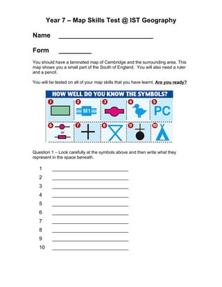
- 1. Year 7 – Map Skills Test @ IST Geography Name __________________________ Form _________ You should have a laminated map of Cambridge and the surrounding area. This map shows you a small part of the South of England. You will also need a ruler and a pencil. You will be tested on all of your map skills that you have learnt. Are you ready? Question 1 – Look carefully at the symbols above and then write what they represent in the space beneath. 1 ___________________________ 2 ___________________________ 3 ___________________________ 4 ___________________________ 5 ___________________________ 6 ___________________________ 7 ___________________________ 8 ___________________________ 9 ___________________________ 10 ___________________________
- 2. Question 11 Look at the scale line on the map of Cambridge. How many centimeters represents 1KM on the line? Answer ___________________________ Question 12 How many centimeters would 3.5KM measure on the scale line? Answer ___________________________ Question 13 One KM is how many metres? Answer ___________________________ Question 14 15,000 metres is how many KM? Answer ___________________________ Question 15 What is the straight line distance between Rowley’s Hill (42 49) and the school (48 49)? Answer ___________________________ Question 16 What is the straight line distance between the church in Foxton (41 48) and the church in Newton (43 49)? Answer ___________________________ Question 17 What is the straight line distance between the Public Phone (46 48) and the Public House (48 49)? Answer ___________________________
- 3. Question 18 Give the four figure grid reference of the bus station in the centre of Cambridge. Answer ___________________________ Question 19 Give the four figure grid reference for junction 11 of the M1 (Clue, there could be more than one!) Answer ___________________________ Question 20 Which town would you find in 46 52? Answer ___________________________ Question 21 What mode of transport would you find in 48 58? Answer ___________________________ Question 22 Name the farm in 42 57 Answer ___________________________ Question 23 How many churches in 44 58? Answer ___________________________ Question 24 What would you find here: 442 507? Answer ___________________________ Question 25 What feature at 462 573? Answer ___________________________
- 4. Question 26 Could you make a phone call at 467 482? Answer ___________________________ Question 27 Which direction would you travel from Barton (40 55) to Trumpington Hall (44 55)? Answer ___________________________ Question 28 Which direction would you travel from Great Shelford (47 52) to Grantchester (42 55)? Answer ___________________________ Question 29 Which direction would you travel from Newton (44 49) to Foxton (41 48) Answer ___________________________ Question 30 You are driving your car down to see your best friend Gaelle. You leave the motorway at Junction 11 (43 53) and want to visit her home which is Charity Farm (41 51). Write out the quickest route that you would take including directions, roads and features that you may pass on route. Try to write about five things here for 5 marks. ________________________________________________________________ ________________________________________________________________ ________________________________________________________________ ________________________________________________________________ ________________________________________________________________ ________________________________________________________________ ________________________________________________________________ ________________________________________________________________ ________________________________________________________________
- 5. Question 31 Name two different ways of showing height on maps: Answer 1 ___________________________ Answer 2 ___________________________ Question 32 How high is the highest land in 40 51? Answer ___________________________ Question 33 Describe the relief of the land in 43 56 in less than five words. Answer _____________________________________________________ Question 34 Complete the sentence below: The closer the __________ lines the __________________ the relief. The further apart the ___________ lines, the ________________ the relief. Question 35 Look closely at the contour mountain on the right. Label the following things in the correct place on the diagram: 1. Summit 2. A gentler slope 3. The steepest slope B 4. A valley 5. An area of land about 65 metres in height. 6. If you travelled from A – B would you be going uphill or A downhill? Answer __________________