Trip to PAKISTAN (part 2)
•
7 likes•1,861 views

find the link to download this presentation on my blog : http://nubiagroup-powerpoint-collection.blogspot.com/

Recommended
More Related Content
Viewers also liked
Viewers also liked (20)
Similar to Trip to PAKISTAN (part 2)
Similar to Trip to PAKISTAN (part 2) (12)
More from Nubia **
More from Nubia ** (20)
Recently uploaded
Recently uploaded (20)
Trip to PAKISTAN (part 2)
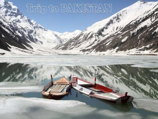
- 24. Yes ! There is a house there
- 27. indus. One of the survivors of the flooding of bridges
- 29. Kashmir is the northwestern region of the Indian subcontinent. Until the mid-19th century, the term Kashmir geographically denoted only the valley between the Great Himalayas and the Pir Panjal mountain range. Today Kashmir denotes a larger area that includes the Indian-administered state of Jammu and Kashmir (the Kashmir valley, Jammu and Ladakh), the Pakistani-administered Gilgit-Baltistan and the Azad Kashmir provinces, and the Chinese-administered regions of Aksai Chin and Trans-Karakoram Tract.
- 30. Indian military on the Siachen glacier.
- 33. Nanga Parbat, the first eight-Himalayas
- 34. View from the Karakorum Highway
- 35. In Tarishinge cloudy and windy. In the background shestitysyachniki Hongra (or Chongryon)
- 39. Hotel Nanga Parbat behind the peaks Chongra
- 45. village school. Since there is no light and warm enough instruction in the street. The boys are dressed almost identically
- 46. School uniform standard - white pants, blue dress, white shawl
- 47. Gradually the weather worsens, the sky is delaying low cloud. This Nanga Parbat's fault. Massif it sticks out over the plateau and "clings" All the clouds are possible. Yes, and the temperature difference in the Indus valley and the top turns a neighborhood in the eight-atmospheric boiler. Using still good weather, people harvest. Hay harvesting and drying of grain by women. By the evening begins to noticeably colder. Have to wear sweaters. At this altitude (3500 meters) already appears a little shortness of breath, and that cold air is not the studio's throat, hiding their mouths.
- 49. Porters
- 50. Rupalsky slope of Nanga Parbat, the height of the mountains 8,129 meters height from the foot of the wall more than 4 km
- 51. This is indeed the King of the mountains (another name for mountain Diamir and translated)!
- 52. End of the World. Batsinsky bottom of the glacier, Nanga Parbat is now behind
- 55. Descended to the glacier
- 56. Beautiful View
- 57. House in the village
- 60. Peaks Shaigiri and Lala
- 61. Nanga Parbat is the ninth highest mountain on Earth and among the eight-thousanders with a summit elevation of 8,126 meters (26,660 ft). Nanga Parbat translates to "Naked Mountain" in English; parbat deriving from the Sanskrit word parvata meaning "mountain, rock", and nanga from the Sanskrit nagna meaning "naked". Known as the "Killer Mountain", Nanga Parbat was one of the deadliest of the eight-thousanders for climbers in the first half of the twentieth century; since that time it has been less so, though still an extremely serious climb. It is also an immense, dramatic peak that rises far above its surrounding terrain. Nanga Parbat forms the western anchor of the Himalayan Range and is the westernmost eight-thousander. It lies just south of the Indus River in the Astore District of Gilgit-Baltistan in Pakistan administered Kashmir. Not far to the north is the western end of the Karakoram range.
- 62. River Jhelum (it Gidaspov). Here the Macedonian army defeated the Indians along this river lay our way to Nanga Parbat The top of Nanga Parbat by Diamirskoy Valley .
- 63. Nanga Parbat - "Naked Mountain". At the top of a slope so steep that the snow does not stick. On the last meters climbers have to deal with climbing
- 64. Apical teeth
- 65. The top of Nanga Parbat is hidden in the mist
- 66. Photos from the archive R. Messner
- 67. At the top of Nanga Parbat (8,126 meters). Avtosemki . Photos from the archive R. Messner
- 68. Samandar Khan against the backdrop of Nanga Parbat. Photos made after the pass
- 69. the base camp Mazeno - 4050 meters
- 70. Front end of the valley Rupalskoy
- 73. A presentation by Nubia [email_address] http://nubiagroup-powerpoint-collection.blogspot.com/ http://groups.yahoo.com/group/Nubia_group_Powerpoint_Collection/