Jual GPS Geodetic Horizon Kronos 300 RTK L1L2L5 Call Budi 082119953499

HUBUNGI KAMI : PT.MINDS INDO SURVEY, DISTRIBUTOR ALAT UKUR SURVEY DAN PEMETAAN, KOMP/RUKO. MEGA KALIMALANG KAV. 8 JLN KH NOER ALI NO. 11,PEKAYON JAYA BEKASI, TLP : 02195099644/ HP : 082119953499 / 087886144398 PIN BB : 237FC845, Klik Web : www.mindsindosurvey.com PENGIRIMAN GRATIS UNTUK WILAYAH DKI Menjual Alat-Alat Untuk Survey Pemetaan, Infrastruktur, Kontraktor, Telekomunikasi, Pertambangan, Geologist, Exploration, Mining, Dirling, Kelautan, Militer, Migas, Pembangunan Pembangunan, Pengelolahan Lahan Lahan Perhutanan Dan Perkebunan Kelapa Sawit. RUANG LINGKUP KEGIATAN PENJUALAN, SERVICE / PERBAIKAN DAN PENYEWAAN ALAT-ALAT UKUR PENJUALAN : • Alat Ukur - Total Station - Altimeter - Theodolite - Digital Planimeter - Levels - Walking Measure - GPS Geodetic - Digital Level / Smart Tool - Compass - Phantograph - Clinometer - Tandem / Clino - Compass • Accessories : - Tripod - Prisma - Rambu Ukur - Meteran - Jalon - Binocular PENYEWAAN : - Total Station - Automatic Level - Theodolite MEREK ALAT UKUR YANG TERSEDIA : - MINDS - SPECTRA - NIKON - SUUNTO - GARMIN - LEICA - HORIZON SERVICE / PERBAIKAN DAN KALIBRASI MACAM-MACAM ALAT UKUR HARGA MENARIK / COMPETITIVE Catatan : Price List akan dikirim sesuai permintaan

Recommended
Recommended
More Related Content
Viewers also liked
Viewers also liked (8)
More from Budi anto
More from Budi anto (20)
Recently uploaded
Recently uploaded (20)
Jual GPS Geodetic Horizon Kronos 300 RTK L1L2L5 Call Budi 082119953499
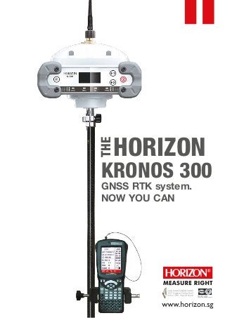
- 1. HORIZON THE KRONOS 300 GNSS RTK system. NOW YOU CAN
- 2. The Kronos 300 is a GNSS receiver that allows you to do more, a HORIZON GNSS product which continues with the tradition of performance excellence shown by the Kronos 200 GNSS system. It now features a more robust and rugged housing, within which resides a faster and more powerful BD970 board built on the proven Maxwell 6 technology. Like the Kronos 200, the Kronos 300 also features an in-built GSM/GPRS module, as well as an in-built UHF transmitter module for a complete communication interface. The UHF module has been upgraded to a power-switchable type, which would allow a transmission range of beyond 8km independently. The completely new Kronos 300 housing now features an illuminated display LED screen, which would let you check on various operation and satellite statuses during operation. It has also been designed to be very rugged and robust, providing safety contingencies for accidental drops from a height of 2metres onto concrete during operation. The waterproofing capability of the Kronos 300 is rated at IP67. Working in the rain (if necessary) would not present any problems. The Kronos 300 has also been fitted with two in-built batteries, with a total capacity of 8800mAH. This would allow you to operate the receiver up to 20hrs when fully charged. You can now do more with the Kronos 300. Yes you can. KRONOS 300 GNSS SYSTEM FEATURES AT A GLANCE: Featuring the Upgraded Trimble Maxwell 6 Technology BD970 Motherboard. An amply proven technology, now made better. Inbuilt GPRS/GSM Module, for a complete and versatile communication interface. UHF Transmitting Antenna- All Direction Antenna (100W, gain 7.5dBI) for extended transmission range. Inbuilt Twin Batteries With a total capacity of 8800mAh, the receiver is capable for operations of up to 20 hours Inbuilt Radio Transmitter The 0.5-2W (switchable) UHF radio module allows coverage of beyond 6km under optimal conditions. Advanced OLED With 1.53’OLED, mode settings and operation status can be easily accessed during operation Outstanding Waterproof Capability IP67 Standard and allows for water immersion of up to 1metre. New and Extremely Rugged Housing Designed and built to withstand a 2m drop onto concrete or other hard surfaces. –
- 3. KRONOS 300 GNSS SYSTEM TECHNICAL SPECIFICATIONS Internal Memory Number of Channels Satellite signals tracked GPS: GLONASS: SBAS: GALILEO: COMPASS: QZSS: Initialization time: Signal recapture: RTK signal initialization: Velocity Accuracy Acceleration Maximum Operating Limits Velocity Altitude Up to 50 Hz raw measurement & position outputs. Very low noise GNSS carrier phase measurements with <1 mm precision in a 1 Hz bandwidth GSM/GPRS bands supported PACKET DATA SERVICE OF GPRS INTERNAL RADIO 4G (15 static days with frequency of 1 Hz) 220 Simultaneous L1 C/A, L2E, L2C, L5 Simultaneous L1 C/A, L1 P, L2 C/A (GLONASS M Only), L2 P Simultaneous L1 C/A, L5 Simultaneous L1 BOC, E5A, E5B, E5AltBOC1 B1,B2 L1 C/A, L1 SAIF,L2C, L5 PERFORMANCE SPECIFICATION PROCESSORS CONNECTION DEVICES 45 sec 1 sec 20 sec Horizontal-0.007 m/s Vertical 0.020m/s 11 g 515m/s 18,000 m Proven low elevation tracking technology. Trimble BD970 main board, GSM/GPRS module: SIEMENS MC75i Maximum rate of transmission 85.6 kbit/s. Single band operation at 800 MHz, Dual band operation at 900 MHz and 1800 MHz, Tri-band operation at 800 MHz, 900 MHz, 1800 MHz. CLASS 10 Embedded TCP/IP protocol suite that supports multiple links and provides ACK answer and large-capacity cache. Connectors I/O: 9-pins serial port (baud rate up to 115.200kbps) Multicable with USB interfaces for connecting with PC. 2.4GHz Bluetooth device class II Maximum range of 50m. Integrated Radio Receiver/Transmitter 0.5-2W selectable 410-430MHZ,430-450MHZ,450-470MHZ Optional ( default 0.5W,450-470MHz) UHF Range(varies with terrain/temperature, and power selected): >4km – 8km With External Radio(optional):25W, UHF Range(varies with terrain/temperature):8-10km typical, 15-20km optimal
- 4. GSM/GPRS MODEM External cellphone support for GPRS/GSM (2G default,3G Optional), Module for network RTK (CORS) Operations, VRS ( optional) Network RTK (via CORS) range varies w/ temperature/GPRS Date rate): 20-50km SERIAL PROTOCOLS Reference outputs Navigation outputs: RECEIVER ACCURACY Static horizontal accuracy Static vertical accuracy Fixed RTK horizontal accuracy Fixed RTK vertical accuracy Code Differential GNSS Positioning ( Horizontal) Code Differential GNSS Positioning ( Vertical) SBAS differential positioning accuracy Working time PHYSICAL SPECIFICATIONS: Weight Humidity CMR+, CMRx, RTCM 2.1, RTCM 2.3, RTCM 3.0, RTCM 3.1. ASCII (NMEA-0183 GSV), AVR, RMC, HDT, VGK, VHD, ROT, GGK, GSA, ZDA, VTG, GST, PJT, PJK, BPQ, GLL, GRS, GBS, GSOF. POWER SUPPLY (12-15V DC EXTERNAL POWER INPUT) Operational temperature 3mm ± 1ppm (RMS). 5mm ± 1ppm (RMS). 8mm ± 1ppm (RMS). 15mm ± 1ppm (RMS). 25cm ± 1ppm (RMS). 50cm ± 1ppm (RMS). <5m 3DRMS Stand Alone RTK positioning accuracy 1.5m (CEP). Rechargeable, 7.2V, 8800mAh Lithium-Ion Size Typically 18-20 hours for built-in battery (varies with operation mode and environmental factors) Storage temperature Waterproof/Dustproof Shock & Vibration resistance Dimensions (LxWxH) 165mm x 168mm x 122mm (6.5in x 6.6in x 4.8in) Weight 1.85kg (including inbuilt battery and radio module) - 45°C to 60°C (-49°F to 140°F) - 55°C to 85°C (-67°F to 185°F) Up to 100% IP67 2m drop against hard surface